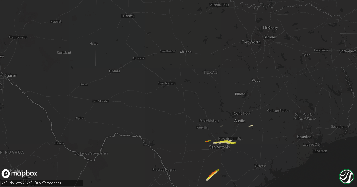
Hail Map in Texas on April 10, 2022
Get this storm
April 10 map
$229
one time, instant access
Download today. No call, no setup
Keep the $229
Bought the map and want the full workflow? Apply the entire $229 to a subscription within 7 days. None of it is wasted.
Every map, not just this one
This buys you this map. Subscription and you get every map we run, in the markets you choose from a few cities to whole states to nationwide. Plus real-time alerts the moment a storm fires.
Contact data
Name, contact info, occupancy, even credit band for addresses in the footprint. You go from where it hit to who to call.
Become the source they trust
Unlimited branding weather history reports on demand. You already have the documented answer ready for the property owner, and you are the one who showed up with it.
Property data and RoofTrace estimates
Pull up any address you have got, its value and the exact code rules for that jurisdiction, straight from One Click Code. Then RoofTrace estimates the squares, pitch, and roof value, priced the way you price.
Storm reports in Texas
Texas
| Date | Description |
|---|---|
| 04/10/20226:38 AM CDT | At 1138 PM CDT, a severe thunderstorm was located near Lakehills, or 13 miles southeast of Bandera, moving east at 35 mph. HAZARD...60 mph wind gusts and quarter size hail. SOURCE...Radar indicated. IMPACT...Hail damage to vehicles is expected. Expect wind damage to roofs, siding, and trees. Locations impacted include... San Antonio, Helotes, Fair Oaks Ranch, Shavano Park, Cross Mountain, Lakehills, Cliff, Leon Springs, Bandera Falls, The Dominion, Mico, Government Canyon State Natural Area, Castle Hills, Grey Forest, San Geronimo, Fiesta Texas, Scenic Oaks, and Lake Medina Shores. |
| 04/10/20226:35 AM CDT | At 1134 PM CDT, a severe thunderstorm was located over McQueeney, or near New Braunfels, moving east at 40 mph. HAZARD...60 mph wind gusts and quarter size hail. SOURCE...Public. IMPACT...Hail damage to vehicles is expected. Expect wind damage to roofs, siding, and trees. Locations impacted include... New Braunfels, Schertz, Seguin, Cibolo, Luling, McQueeney, Marion, Kingsbury, Santa Clara, New Berlin, Staples, Zuehl, Fentress, Geronimo, Zorn, Nolte, Zipp, Stairtown, Belmont, and Freiheit. |
| 04/10/20225:48 AM CDT | At 1047 PM CDT, a severe thunderstorm was located over Leon Valley, or near San Antonio, moving east at 40 mph. HAZARD...60 mph wind gusts and quarter size hail. SOURCE...Radar indicated. IMPACT...Hail damage to vehicles is expected. Expect wind damage to roofs, siding, and trees. Locations impacted include... San Antonio, New Braunfels, Schertz, Seguin, Cibolo, Universal City, Live Oak, Selma, San Antonio Int Airport, Randolph AFB, Leon Valley, Helotes, Kirby, Alamo Heights, Windcrest, Terrell Hills, Bulverde, Garden Ridge, Shavano Park, and Hollywood Park. |
| 04/10/20223:32 AM CDT | At 831 PM CDT, a severe thunderstorm was located near Cross, or 12 miles north of Tilden, moving northeast at 45 mph. HAZARD...60 mph wind gusts and half dollar size hail. SOURCE...Radar indicated. IMPACT...Hail damage to vehicles is expected. Expect wind damage to roofs, siding, and trees. Locations impacted include... Pleasanton, Jourdanton, Christine, Campbellton, Coughran, Peggy, Graytown, McCoy, and Fashing. |
| 04/10/20223:06 AM CDT | At 806 PM CDT, a severe thunderstorm was located over Fowlerton, or 17 miles west of Tilden, moving northeast at 40 mph. HAZARD...60 mph wind gusts and quarter size hail. SOURCE...Radar indicated. IMPACT...Hail damage to vehicles is expected. Expect wind damage to roofs, siding, and trees. Locations impacted include... Tilden, Crowther, Cross, Zella and Fowlerton. |
| 04/10/20222:08 AM CDT | At 707 PM CDT, a severe thunderstorm was located near Callaghan, or near Encinal, moving east at 25 mph. HAZARD...60 mph wind gusts and quarter size hail. SOURCE...Radar indicated. IMPACT...Hail damage to vehicles is expected. Expect wind damage to roofs, siding, and trees. Locations impacted include... Encinal, Fort Ewell Site and Callaghan. This includes Interstate 35 between mile markers 26 and 38. |
| 04/09/202211:28 PM CDT | A local report indicates 1.00 inch wind near 2 NE CIBOLO |
| 04/09/202211:24 PM CDT | A local report indicates 1.00 inch wind near 1 NNE SCHERTZ |
| 04/09/202211:15 PM CDT | A local report indicates 1.00 inch wind near 3 WNW LIVE OAK |
| 04/09/202211:08 PM CDT | Public report relayed via social media of quarter size hail at the intersection of de zavala road and interstate 10. |
| 04/09/20228:15 PM CDT | A wind gust measured at 58 mph tore a 10 foot by 20 foot section of the roof off a house which damaged power lines resulting in a power outage. |
Cities Impacted by Hail Map on April 10, 2022
- Cleveland, OK
- Prue, OK
- Pawnee, OK
- Barnsdall, OK
- Hominy, OK
- Pawhuska, OK
- Morrison, OK
- Wynona, OK
- Fairfax, OK
- Ralston, OK
- Osage, OK
- Skiatook, OK
- Stockton, MO
- Tilden, TX
- Ash Grove, MO
- Everton, MO
- Willard, MO
- Brighton, MO
- Hillsboro, MO
- Fletcher, MO
- Blackwell, MO
- De Soto, MO
- Potosi, MO
- Richwoods, MO
- Sullivan, MO
- Bolivar, MO
- Buffalo, MO
- Half Way, MO
- Morrisville, MO
- Oronogo, MO
- Jasper, MO
- Asbury, MO
- Garber, OK
- Enid, OK
- Kremlin, OK
- Bastrop, TX
- San Marcos, TX
- Seguin, TX
- Marion, TX
- Fowlerton, TX
- Cotulla, TX
- Cibolo, TX
- Schertz, TX
- San Antonio, TX
- Hunter, OK
- Steelville, MO
- New Braunfels, TX
- McQueeney, TX
- Universal City, TX
- Helotes, TX
- Alma, MI
- Saint Louis, MI
- Delaware, OK
- Bois D Arc, MO
- Pleasant Hope, MO
- Elkland, MO
- Walnut Grove, MO
- Nowata, OK
- Bartlesville, OK
- Lenapah, OK
- Bourbon, MO
- Wheatland, MO
- Pittsburg, MO
- Weaubleau, MO
- Flemington, MO
- Humansville, MO
- Urbana, MO
- Polk, MO
- Louisburg, MO
- Hermitage, MO
- Sparta, IL
- Evansville, IL
- Baldwin, IL
- Pipe Creek, TX
- Festus, MO
- Fair Play, MO
- Ponca City, OK
- Rolla, MO
- Newburg, MO
- Osage Beach, MO
- Sunrise Beach, MO
- Jerico Springs, MO
- Lockwood, MO
- Arcola, MO
- Fairmont, OK
- Carthage, MO
- Diamond, MO
- Sarcoxie, MO
- Reeds, MO
- Webb City, MO
- Miller, MO
- Duenweg, MO
- Riverton, KS
- La Russell, MO
- Avilla, MO
- Golden City, MO
- Baxter Springs, KS
- Joplin, MO
- Columbus, KS
- Carterville, MO
- Galena, KS
- Long Lane, MO
- Lebanon, MO
- Windyville, MO
- Wheeler, MI
- Breckenridge, MI
- Sumner, MI
- Riverdale, MI
- Elwell, MI
- Greenfield, MO
- Frankford, MO
- Chetopa, KS
- Ramona, OK
- Pinckneyville, IL
- Collins, MO
- Prairie Du Rocher, IL
- Chelsea, MI
- Grass Lake, MI
- Cook Sta, MO
- Saint James, MO
- Perry, OK
- Fults, IL
- Red Bud, IL
- Tamaroa, IL
- Cadet, MO
- Dittmer, MO
- Holts Summit, MO
- Ochelata, OK
- Coulterville, IL
- Valmeyer, IL
- Cedar Creek, TX
- Nash, OK
- Carrier, OK
- Pond Creek, OK
- Dunnegan, MO
- Marissa, IL
- Modoc, IL
- Westphalia, MO
- Saint Thomas, MO
- Jefferson City, MO
- Weir, KS
- Pittsburg, KS
- Shidler, OK
- Converse, IN
- Amboy, IN
- Waynesville, MO
- Fort Leonard Wood, MO
- Cherryville, MO
- Davisville, MO
- Hermann, MO
- South Greenfield, MO
- Carl Junction, MO
- Welch, OK
- Jackson, MI
- Clarklake, MI
- Brooklyn, MI
- Burbank, OK
- Blanco, TX
- Edgar Springs, MO
- Claremore, OK
- Laredo, TX
- Charlotte, TX
- Jourdanton, TX
- Bandera, TX
- Mico, TX
- Springfield, MO
- Conway, MO
- Niangua, MO
- Grovespring, MO
- Herculaneum, MO
- Crystal City, MO


