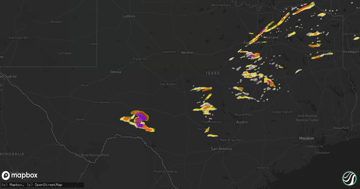
Hail Map in Texas on April 10, 2017
Get this storm
April 10 map
$229
one time, instant access
Download today. No call, no setup
Keep the $229
Bought the map and want the full workflow? Apply the entire $229 to a subscription within 7 days. None of it is wasted.
Every map, not just this one
This buys you this map. Subscription and you get every map we run, in the markets you choose from a few cities to whole states to nationwide. Plus real-time alerts the moment a storm fires.
Contact data
Name, contact info, occupancy, even credit band for addresses in the footprint. You go from where it hit to who to call.
Become the source they trust
Unlimited branding weather history reports on demand. You already have the documented answer ready for the property owner, and you are the one who showed up with it.
Property data and RoofTrace estimates
Pull up any address you have got, its value and the exact code rules for that jurisdiction, straight from One Click Code. Then RoofTrace estimates the squares, pitch, and roof value, priced the way you price.
Storm reports in Texas
Texas
| Date | Description |
|---|---|
| 04/10/20175:22 PM CDT | Quarter size hail reported via social media just north of clifton middle school |
| 04/10/20175:12 PM CDT | Golfball size hail reported in clifton at the high school |
| 04/10/20174:38 PM CDT | 1 inch hail reported in lakeside village reported by local fd via radio |
| 04/10/20174:16 PM CDT | A local report indicates 1.00 inch wind near 5 N RICHLAND SPRINGS |
| 04/10/20174:12 PM CDT | A local report indicates 1.00 inch wind near 5 NW RICHLAND SPRINGS |
| 04/10/20174:09 PM CDT | Quarter size hail reported in alvarado per social media |
| 04/10/20174:01 PM CDT | Golfball size hail reported 5 miles nw of grandview via spotter |
| 04/10/20173:30 PM CDT | Delayed report: half dollar size hail reported in cleburne via social media |
| 04/10/20173:22 PM CDT | Half dollar size hail reported in cleburne by em |
| 04/10/20173:20 PM CDT | Via social media... Half dollar to ping pong size |
| 04/10/20173:19 PM CDT | Amateur radio spotter reported quarter size hail |
| 04/10/20173:12 PM CDT | Golfball to baseball size hail reported near walls hospital at henderson and hwy 67 in cleburne |
| 04/10/20173:09 PM CDT | Quarter size hail reported in cleburne |
| 04/10/20173:07 PM CDT | 1 inch hail lake cleburne |
| 04/10/20173:04 PM CDT | 4 miles wnw of allen tx |
| 04/10/20172:54 PM CDT | Quarter size hail reported in frisco; rolater rd |
| 04/10/201710:43 AM CDT | 2 recreational vehicles were overturned |
| 04/10/20174:30 AM CDT | Quarter sized hail reported 5 miles north of boerne. |
| 04/10/20174:22 AM CDT | Hail slightly larger than quarters reported by boerne police department along interstate 10 just nw of boerne. Time estimated from radar. |
| 04/10/20174:09 AM CDT | Near the intersection of 190 and 195 |
| 04/10/20173:28 AM CDT | A local report indicates 1.00 inch wind near NORTH RICHLAND HILLS |
| 04/10/20173:12 AM CDT | A local report indicates 1.00 inch wind near FORT WORTH |
| 04/10/20173:00 AM CDT | A local report indicates 1.00 inch wind near 3 W FORT WORTH |
| 04/10/20173:00 AM CDT | Quarter size hail for 3 minutes in river oaks |
| 04/10/20172:58 AM CDT | Nickel to quarter size hail near camp bowie and i-30 |
| 04/10/20172:35 AM CDT | Near western center and i-35 |
| 04/10/20172:10 AM CDT | A local report indicates 1.50 inch wind near GRANBURY |
| 04/10/201712:41 AM CDT | Hail reported 2 mi wsw of prosper |
| 04/10/201712:40 AM CDT | Golfball size hail reported in frisco |
| 04/10/201712:35 AM CDT | Saturated soils combined with wind speeds of 45 mph uprooted several trees in the city of tyler. |
| 04/10/201712:26 AM CDT | Golfball hail reported 3 mi e of little elm |
| 04/10/201712:24 AM CDT | 2 inch hail reported in west frisco |
| 04/10/201712:23 AM CDT | Quarter size hail reported 1 mi ne of dodd city |
| 04/10/201712:22 AM CDT | Golfball size hail reported in frisco |
| 04/10/201712:15 AM CDT | Golfball size hail reported in hackberry |
| 04/10/201712:11 AM CDT | Flower mound... Golfball size hail reported |
| 04/10/201712:01 AM CDT | Half dollar size hail reported in flower mound |
| 04/09/201711:55 PM CDT | A local report indicates 1.00 inch wind near LOYAL VALLEY |
| 04/09/201711:54 PM CDT | Fire station 5 in flower mound reports quarter size hail for the last 10 min |
| 04/09/201711:52 PM CDT | Quarter size hail reported in lewisville |
| 04/09/201711:51 PM CDT | Nickel size hail reported in flower mound |
| 04/09/201711:45 PM CDT | Quarter size hail being reported in mildred and eureka |
| 04/09/201711:45 PM CDT | Delayed report: quater size hail in southlake |
| 04/09/201711:30 PM CDT | Powerlines blocking the road at fm 1860 and koehne road between riesel and mart |
| 04/09/201711:30 PM CDT | Reports of 60+ mph winds in thornton... Hwy 14 and fm 1246 |
| 04/09/201711:25 PM CDT | Golfball size hail in thorton... Hwy 14 and fm 1246 |
| 04/09/201711:00 PM CDT | Delayed report: 1 inch hail reported at wx station in fort hood |
| 04/09/201710:50 PM CDT | Tennis ball hail reported in the city of mart |
| 04/09/201710:43 PM CDT | Roof of unknown building on the side of batttle lake road |
| 04/09/201710:30 PM CDT | Social media report of 1 inch hail in mckinney |
| 04/09/201710:12 PM CDT | Near the county line on fm2083 |
| 04/09/20179:15 PM CDT | Hail fell until 10 pm. Hail busted windows on two vehicles and a residence. The large hail killed 12 lambs. |
| 04/09/20179:05 PM CDT | A local report indicates 1.50 inch wind near 6 E MASON |
| 04/09/20179:00 PM CDT | Widespread trees down across county. |
| 04/09/20179:00 PM CDT | Quarter size hail reported in leroy |
| 04/09/20178:41 PM CDT | Golfball size hail reported 5 mi wnw of china spring |
| 04/09/20178:39 PM CDT | Kytx reports large tree down on county road 26 in far eastern smith county. |
| 04/09/20178:31 PM CDT | Spotter reporting quarter size hail 4 mi ssw of aquilla |
| 04/09/20178:05 PM CDT | Public reports hail via ketk facebook in south kilgore. |
| 04/09/20177:46 PM CDT | 8 inch diameter tree limbs in cayote |
| 04/09/20177:35 PM CDT | Ef1 tornado damage consisted of several trees that were snapped and uprooted and some minor shingle damage occurred to one home. The most concentrated damage was found |
| 04/09/20177:34 PM CDT | Golfball size hail on fm 906e approx 2 mi of fm 195 near the community of novice... 16 mi ne of paris |
| 04/09/20177:25 PM CDT | Golfball size hail reported 5 mi n of paris near hwy 271 |
| 04/09/20177:17 PM CDT | Golfball size hail reported on county road 2210. |
| 04/09/20177:10 PM CDT | Ef 1 tornado damage consisted of several uprooted trees along a narrow path. |
All States Impacted by Hail Map on April 10, 2017
Cities Impacted by Hail Map on April 10, 2017
- Granbury, TX
- Stephenville, TX
- Leslie, MO
- Saint Charles, MO
- Washington, MO
- Defiance, MO
- Augusta, MO
- Marthasville, MO
- Saint Joseph, IL
- Urbana, IL
- Saint Jacob, IL
- Troy, IL
- Collinsville, IL
- Hillview, IL
- Roodhouse, IL
- Winchester, IL
- Flanagan, IL
- El Paso, IL
- Bunker Hill, IL
- Mount Olive, IL
- Walshville, IL
- Litchfield, IL
- Staunton, IL
- Leesburg, TX
- Pittsburg, TX
- Hillsboro, IL
- Irving, IL
- Butler, IL
- Big Sandy, TX
- Blue Ridge, TX
- Whitney, TX
- Grandview, TX
- Cleburne, TX
- Alvarado, TX
- Keene, TX
- Godley, TX
- Art, TX
- Mason, TX
- Valley Spring, TX
- Pontotoc, TX
- Ennis, TX
- Ozona, TX
- East Peoria, IL
- Peoria, IL
- Mapleton, IL
- Creve Coeur, IL
- Washington, IL
- Spencerville, OK
- Rattan, OK
- Rio Vista, TX
- Llano, TX
- Castell, TX
- La Porte, IN
- Union Mills, IN
- Lemont, IL
- Ashdown, AR
- Mckinney, TX
- Little Elm, TX
- Princeton, TX
- Hurst, TX
- North Richland Hills, TX
- Windom, TX
- Grapevine, TX
- Flower Mound, TX
- Randolph, TX
- Keller, TX
- Allen, TX
- Fort Worth, TX
- Trenton, TX
- Lewisville, TX
- Leonard, TX
- Colleyville, TX
- Frisco, TX
- Haltom City, TX
- Southlake, TX
- Dodd City, TX
- Prosper, TX
- Bonham, TX
- Bedford, TX
- Lake Dallas, TX
- Plano, TX
- The Colony, TX
- Naval Air Station Jrb, TX
- Mount Calm, TX
- Brookston, IN
- Kemp, TX
- Westfield, IL
- Charleston, IL
- Thornton, TX
- Mart, TX
- Newman, IL
- Hume, IL
- Boerne, TX
- Itasca, TX
- Maypearl, TX
- Ladonia, TX
- Wolfe City, TX
- Sheridan, IN
- Clarksville, TX
- Avery, TX
- Annona, TX
- De Kalb, TX
- Chase, MI
- Idlewild, MI
- Addieville, IL
- Argyle, WI
- South Wayne, WI
- Browntown, WI
- Monroe, WI
- Danville, IL
- Collison, IL
- Fithian, IL
- Valley Mills, TX
- Newark, IL
- Plainfield, IL
- Oswego, IL
- Yorkville, IL
- Dryden, TX
- Comstock, TX
- Elm Mott, TX
- Axtell, TX
- West, TX
- Boswell, IN
- Oxford, IN
- Cuba, IL
- Canton, IL
- Blum, TX
- Riesel, TX
- Waco, TX
- Groesbeck, TX
- Prairie Hill, TX
- Kosse, TX
- Cameron, TX
- Mchenry, IL
- Del Rio, TX
- Longview, TX
- Kilgore, TX
- Lafayette, IN
- Richmond, IL
- Jewett, TX
- Monticello, WI
- Albany, WI
- Joliet, IL
- Kingston, IL
- Wills Point, TX
- White Cloud, MI
- Big Rapids, MI
- Delphi, IN
- Westpoint, IN
- Rossville, IN
- Clifton, TX
- Gatesville, TX
- Jonesboro, TX
- Nolanville, TX
- Belton, TX
- Harker Heights, TX
- Hanna City, IL
- Glasford, IL
- Anna, TX
- Meridian, TX
- Powderly, TX
- Paris, TX
- Comfort, TX
- Center Point, TX
- Kerrville, TX
- Arthur City, TX
- Sumner, TX
- Gilmer, TX
- Hughes Springs, TX
- Blooming Grove, TX
- Barry, TX
- San Saba, TX
- China Spring, TX
- Aquilla, TX
- Trivoli, IL
- Grant, OK
- Fredericksburg, TX
- Iredell, TX
- Lone Oak, TX
- Cumby, TX
- Cotton Valley, LA
- Brashear, TX
- Point, TX
- Quinlan, TX
- Greenville, TX
- Overton, TX
- Arp, TX
- Tyler, TX
- Franklin, TX
- Honey Grove, TX
- Pearl, IL
- Milford, TX
- Hillsboro, TX
- Mertens, TX
- Beecher City, IL
- Altamont, IL
- Cutler, IN
- Crown Point, IN
- Valparaiso, IN
- Hebron, IN
- Rochelle, TX
- Fredonia, TX
- Junction, TX
- London, TX
- Pontiac, IL
- West Lafayette, IN
- Piper City, IL
- Cullom, IL
- Petty, TX
- Sawyer, OK
- Fort Towson, OK
- Hugo, OK
- Joshua, TX
- Killeen, TX
- Daingerfield, TX
- Richland Springs, TX
- Bridgeview, IL
- Hickory Hills, IL
- Justice, IL
- Willow Springs, IL
- Milford, IL
- Cissna Park, IL
- Marshall, IL
- Paris, IL
- Bluff Dale, TX
- Virden, IL
- Modesto, IL
- Palmyra, IL
- Girard, IL
- Merritt, MI
- Sulphur Springs, TX
- Sigel, IL
- Neoga, IL
- Smithfield, IL
- Grafton, IL
- Brussels, IL
- Bluffs, IL
- Griggsville, IL
- Meredosia, IL
- Attica, IN
- Flora, IN
- Bringhurst, IN
- Bagwell, TX
- Brookston, TX
- Detroit, TX
- Blossom, TX
- Steelville, MO
- Davisville, MO
- Lohn, TX
- Morgan, TX
- Kopperl, TX
- Rossville, IL
- Alvin, IL
- Williamsport, IN
- Henning, IL
- Haworth, OK
- Fort Hood, TX
- Kempner, TX
- Copperas Cove, TX
- Woodway, TX
- Crawford, TX
- Mount Morris, IL
- Oregon, IL
- Polo, IL
- Dixon, IL
- Montezuma, IN
- Rockville, IN
- Round Lake, IL
- Ingleside, IL
- Lake Villa, IL
- Fox Lake, IL
- Italy, TX
- Odell, IL
- Chenoa, IL
- Corsicana, TX
- Farmington, IL
- Fairview, IL
- Gerald, MO
- East Jordan, MI
- Ellsworth, MI
- Moweaqua, IL
- Suttons Bay, MI
- Northport, MI
- Lake Leelanau, MI
- Leland, MI
- Gurnee, IL
- Grayslake, IL
- Libertyville, IL
- Waukegan, IL
- Franklin, IL
- Waverly, IL
- Aledo, TX
- Wilmot, WI
- Antioch, IL
- Burlington, WI
- Salem, WI
- Twin Lakes, WI
- Trevor, WI
- Spring Grove, IL
- Hawkins, TX
- Winnsboro, TX
- Royal, IL
- Loami, IL
- Salem, MO
- London Mills, IL
- Prairie City, IL
- Bushnell, IL
- Macomb, IL
- Avon, IL
- Ellisville, IL
- Ramsey, IL
- Temple, TX
- Eureka, IL
- Graymont, IL
- Bingham, IL
- Hico, TX
- Beaverville, IL
- Papineau, IL
- Martinton, IL
- Saint Anne, IL
- Potomac, IL
- Ogden, IL
- Armstrong, IL
- Penfield, IL
- Wadsworth, IL
- Scroggins, TX
- Mount Pleasant, TX
- Pipe Creek, TX
- Melvin, TX
- Frankston, TX
- Palestine, TX
- Tennessee Colony, TX
- Montalba, TX
- Homer Glen, IL
- Monticello, IN
- Chalmers, IN
- Effingham, IL
- Teutopolis, IL
- Lake Creek, TX
- Enloe, TX
- Cooper, TX
- Wright City, OK
- Valliant, OK
- White Hall, IL
- Eldred, IL
- Kinmundy, IL
- Alma, IL
- Coffeen, IL
- Wanatah, IN
- Cherryville, MO
- Omaha, TX
- Gladewater, TX
- Dousman, WI
- Oconomowoc, WI
- Sullivan, WI
- Sterling, IL
- Lone Star, TX
- Avinger, TX
- Toledo, IL
- Montrose, IL
- Harrison, MI
- Potosi, MO
- Cayuga, IN
- Hillsdale, IN
- Bloomingdale, IN
- Kingman, IN
- Chicago Ridge, IL
- Oak Lawn, IL
- Alsip, IL
- Palos Heights, IL
- Worth, IL
- Celina, TX
- Arlington, TX
- Monee, IL
- Roanoke, TX
- Ringwood, IL
- Wonder Lake, IL
- Russellville, IN
- Adair, IL
- Peoria Heights, IL
- Marietta, IL
- Pekin, IL
- Gridley, IL
- Table Grove, IL
- Secor, IL
- Roanoke, IL
- Metamora, IL
- Minonk, IL
- Saunemin, IL
- Norris, IL
- Benson, IL
- Morton, IL
- Leroy, MI
- Tustin, MI
- Evart, MI
- Farina, IL
- Saint Peter, IL
- Mason, IL
- Cranfills Gap, TX
- Burlington, TX
- Plain Dealing, LA
- Rogers, TX
- Golden Eagle, IL
- Scott, AR
- Marlin, TX
- Murrayville, IL
- Clare, MI
- Brady, TX
- Byron, IL
- Waxahachie, TX
- Vandalia, IL
- Crawfordsville, IN
- Abbott, TX
- Buckholts, TX
- Leaf River, IL
- Plano, IL
- Lott, TX
- Rosebud, TX
- Kenosha, WI
- Casey, IL
- Covington, TX
- Camden, IN
- Logansport, IN
- Nashville, AR
- McCaskill, AR
- Coolidge, TX
- Wheatley, AR
- North Liberty, IN
- Willowbrook, IL
- Gratiot, WI
- Coppell, TX
- Irving, TX
- Chatsworth, IL
- Telephone, TX
- Ivanhoe, TX
- University Park, IL
- Richton Park, IL
- Minden, LA
- Hallsville, TX
- Marshall, TX
- Chana, IL
- Shipman, IL
- Palatine, IL
- Terre Haute, IN
- Emerson, AR
- Fennville, MI
- Dallas, TX
- Carrollton, TX
- Martinsville, IL
- Sarepta, LA
- Westville, IN
- Frankfort, IN
- Grand Prairie, TX
- Prescott, AR
- Lowell, IN
- Saint Peters, MO
- Rankin, IL
- Cowden, IL
- Fillmore, IL
- Forrest, IL
- Dennison, IL
- West Terre Haute, IN
- Arcola, IL
- Barrington, IL
- Hoffman Estates, IL
- Deerfield, IL
- Lincolnshire, IL
- Wheeling, IL
- Arlington Heights, IL
- Buffalo Grove, IL
- Crystal Lake, IL
- Woodstock, IL
- Camargo, IL
- Oakland, IL
- Tuscola, IL
- Hindsboro, IL
- Shorewood, IL
- Bethany, IL
- Hope, AR
- Lake Saint Louis, MO
- O'Fallon, MO
- Woodridge, IL
- Bolingbrook, IL
- Seneca, IL
- Romeoville, IL
- Sheridan, IL
- Henderson, TX
- Tatum, TX
- Whitehouse, TX
- Roscommon, MI
- Kirklin, IN
- Justin, TX
- Rhome, TX
- Haslet, TX
- Farmersville, TX
- Nevada, TX
- Ravenna, TX
- Winona, TX
- Lometa, TX
- Lampasas, TX
- Gladwin, MI
- Zapata, TX
- Chicago, IL
- Mount Vernon, TX
- Gifford, IL
- Stewardson, IL
- Little River Academy, TX
- Briggs, TX
- Otterbein, IN
- Rainbow, TX
- Glen Rose, TX
- Rolling Prairie, IN
- Reagan, TX
- Houghton Lake, MI
- Dieterich, IL
- Shelbyville, IL
- Assumption, IL
- Cookville, TX
- Doole, TX
- Shongaloo, LA
- Haynesville, LA
- Waterloo, IL
- Zion, IL
- Island Lake, IL
- Foreman, AR
- Edwardsville, IL
- Doss, TX
- Pickton, TX
- Hewitt, TX
- Rockford, IL
- Marshall, IN
- Mayville, MI
- Commerce, TX
- Vernon, IL
- Shobonier, IL
- Union, IL
- Marengo, IL
- Wheeler, IL
- Jewett, IL
- Hart, MI
- Montague, MI
- Shelby, MI
- New Era, MI
- Batavia, IL
- Aurora, IL
- Sugar Grove, IL
- North Aurora, IL
- Geneva, IL
- Elburn, IL
- Hinckley, IL
- Big Rock, IL
- Franksville, WI
- Harvard, IL
- Garden Prairie, IL
- Sturtevant, WI
- Hebron, IL
- Kansasville, WI
- Racine, WI
- Genoa City, WI
- Silver Lake, WI
- Union Grove, WI
- Lockport, IL
- Palos Hills, IL
- Palos Park, IL
- Crest Hill, IL
- Minooka, IL
- Evergreen Park, IL
- Orland Park, IL
- Hometown, IL
- Hammond, IN
- Chatham, IL
- Springfield, IL
- New Berlin, IL
- Dow, IL
- Jerseyville, IL
- Venus, TX
- Melissa, TX
- Van Alstyne, TX
- Streetman, TX
- Newark, TX
- Oakwood, IL
- La Crosse, IN
- Kouts, IN
- Hanna, IN
- Battle Ground, IN


