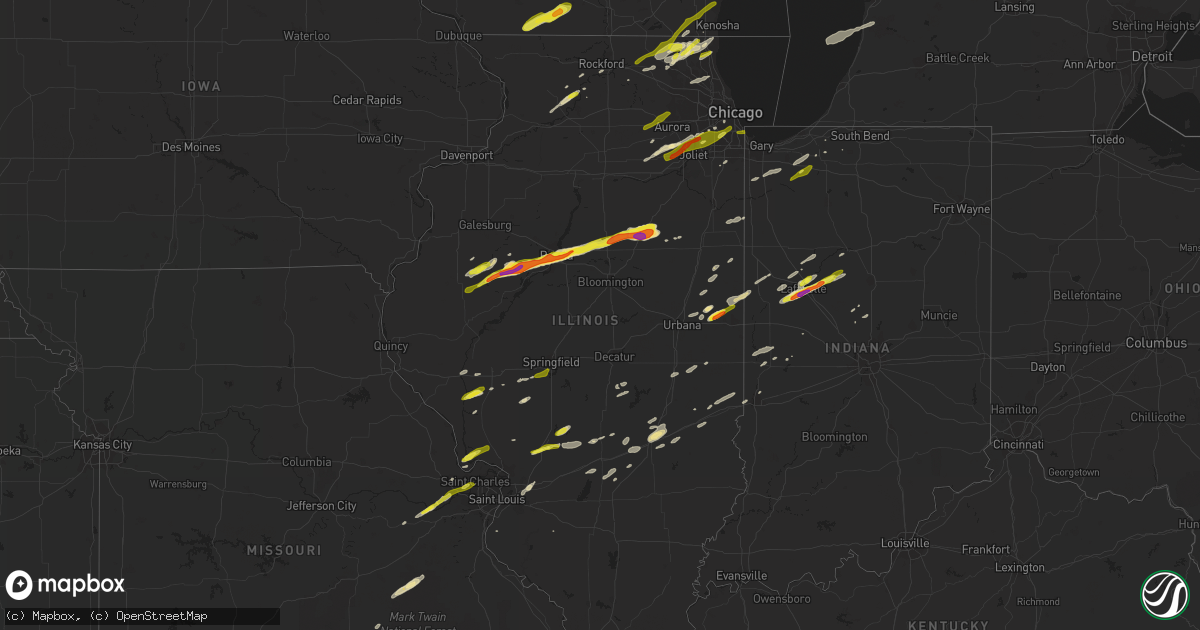
Hail Map in Illinois on April 10, 2017
Get this storm
April 10 map
$229
one time, instant access
Download today. No call, no setup
Keep the $229
Bought the map and want the full workflow? Apply the entire $229 to a subscription within 7 days. None of it is wasted.
Every map, not just this one
This buys you this map. Subscription and you get every map we run, in the markets you choose from a few cities to whole states to nationwide. Plus real-time alerts the moment a storm fires.
Contact data
Name, contact info, occupancy, even credit band for addresses in the footprint. You go from where it hit to who to call.
Become the source they trust
Unlimited branding weather history reports on demand. You already have the documented answer ready for the property owner, and you are the one who showed up with it.
Property data and RoofTrace estimates
Pull up any address you have got, its value and the exact code rules for that jurisdiction, straight from One Click Code. Then RoofTrace estimates the squares, pitch, and roof value, priced the way you price.
Storm reports in Illinois
Illinois
| Date | Description |
|---|---|
| 04/10/20176:30 PM CDT | Largest hail 1 inch...average 0.5 inch. |
| 04/10/20174:41 PM CDT | A local report indicates 1.00 inch wind near MCHENRY |
| 04/10/20174:39 PM CDT | A local report indicates 2.00 inch wind near PONTIAC |
| 04/10/20174:23 PM CDT | Report via social media |
| 04/10/20174:20 PM CDT | A local report indicates 1.00 inch wind near 5 N EL PASO |
| 04/10/20174:10 PM CDT | A local report indicates 1.25 inch wind near 4 NE ISLAND LAKE |
| 04/10/20173:52 PM CDT | A local report indicates 1.75 inch wind near WASHINGTON |
| 04/10/20173:45 PM CDT | Delayed report. |
| 04/10/20173:42 PM CDT | A local report indicates 1.75 inch wind near EAST PEORIA |
| 04/10/20173:39 PM CDT | A local report indicates 1.00 inch wind near PEORIA |
| 04/10/20173:35 PM CDT | Delayed report. |
| 04/10/20173:30 PM CDT | Delayed report. |
| 04/10/20173:20 PM CDT | A local report indicates 1.75 inch wind near 1 N PEORIA INTERNATIONA |
| 04/10/20173:11 PM CDT | Delayed report. |
| 04/10/20173:10 PM CDT | A local report indicates 2.00 inch wind near CANTON |
| 04/10/20173:10 PM CDT | A local report indicates 1.00 inch wind near ANTIOCH |
| 04/10/20173:10 PM CDT | A local report indicates 1.75 inch wind near 1 NE NORRIS |
| 04/10/20173:06 PM CDT | A local report indicates 1.00 inch wind near CANTON |
| 04/10/20173:04 PM CDT | A local report indicates 1.75 inch wind near CANTON |
| 04/10/20173:00 PM CDT | A local report indicates 2.50 inch wind near CANTON |
| 04/10/20172:49 PM CDT | A local report indicates 1.00 inch wind near 2 N CUBA |
| 04/10/20171:18 PM CDT | Reported by social media. |
| 04/10/20171:00 PM CDT | Lots of hail damage.person was not present when the hail fell so the hail was probably larger. Screens on the home were shredded and damage also to the homes siding. |
| 04/10/201712:55 PM CDT | Penny to quarter size. Caton farm rd near rt 59. |
| 04/10/201712:51 PM CDT | A local report indicates 1.75 inch wind near 3 N MINOOKA |
| 04/10/20177:50 AM CDT | Time estimated by radar. |
| 04/10/20177:40 AM CDT | Time estimated by radar. |
| 04/10/20177:35 AM CDT | Delayed report. |
| 04/09/20177:55 PM CDT | Lasted 3 to 4 minutes followed by heavy rain. Scattered hail still on ground at 9:20 am. No damage. |
| 04/09/20177:35 PM CDT | Delayed report. |
| 04/09/20177:06 PM CDT | A local report indicates 1.00 inch wind near TROY |
All States Impacted by Hail Map on April 10, 2017
Cities Impacted by Hail Map on April 10, 2017
- Granbury, TX
- Stephenville, TX
- Leslie, MO
- Saint Charles, MO
- Washington, MO
- Defiance, MO
- Augusta, MO
- Marthasville, MO
- Saint Joseph, IL
- Urbana, IL
- Saint Jacob, IL
- Troy, IL
- Collinsville, IL
- Hillview, IL
- Roodhouse, IL
- Winchester, IL
- Flanagan, IL
- El Paso, IL
- Bunker Hill, IL
- Mount Olive, IL
- Walshville, IL
- Litchfield, IL
- Staunton, IL
- Leesburg, TX
- Pittsburg, TX
- Hillsboro, IL
- Irving, IL
- Butler, IL
- Big Sandy, TX
- Blue Ridge, TX
- Whitney, TX
- Grandview, TX
- Cleburne, TX
- Alvarado, TX
- Keene, TX
- Godley, TX
- Art, TX
- Mason, TX
- Valley Spring, TX
- Pontotoc, TX
- Ennis, TX
- Ozona, TX
- East Peoria, IL
- Peoria, IL
- Mapleton, IL
- Creve Coeur, IL
- Washington, IL
- Spencerville, OK
- Rattan, OK
- Rio Vista, TX
- Llano, TX
- Castell, TX
- La Porte, IN
- Union Mills, IN
- Lemont, IL
- Ashdown, AR
- Mckinney, TX
- Little Elm, TX
- Princeton, TX
- Hurst, TX
- North Richland Hills, TX
- Windom, TX
- Grapevine, TX
- Flower Mound, TX
- Randolph, TX
- Keller, TX
- Allen, TX
- Fort Worth, TX
- Trenton, TX
- Lewisville, TX
- Leonard, TX
- Colleyville, TX
- Frisco, TX
- Haltom City, TX
- Southlake, TX
- Dodd City, TX
- Prosper, TX
- Bonham, TX
- Bedford, TX
- Lake Dallas, TX
- Plano, TX
- The Colony, TX
- Naval Air Station Jrb, TX
- Mount Calm, TX
- Brookston, IN
- Kemp, TX
- Westfield, IL
- Charleston, IL
- Thornton, TX
- Mart, TX
- Newman, IL
- Hume, IL
- Boerne, TX
- Itasca, TX
- Maypearl, TX
- Ladonia, TX
- Wolfe City, TX
- Sheridan, IN
- Clarksville, TX
- Avery, TX
- Annona, TX
- De Kalb, TX
- Chase, MI
- Idlewild, MI
- Addieville, IL
- Argyle, WI
- South Wayne, WI
- Browntown, WI
- Monroe, WI
- Danville, IL
- Collison, IL
- Fithian, IL
- Valley Mills, TX
- Newark, IL
- Plainfield, IL
- Oswego, IL
- Yorkville, IL
- Dryden, TX
- Comstock, TX
- Elm Mott, TX
- Axtell, TX
- West, TX
- Boswell, IN
- Oxford, IN
- Cuba, IL
- Canton, IL
- Blum, TX
- Riesel, TX
- Waco, TX
- Groesbeck, TX
- Prairie Hill, TX
- Kosse, TX
- Cameron, TX
- Mchenry, IL
- Del Rio, TX
- Longview, TX
- Kilgore, TX
- Lafayette, IN
- Richmond, IL
- Jewett, TX
- Monticello, WI
- Albany, WI
- Joliet, IL
- Kingston, IL
- Wills Point, TX
- White Cloud, MI
- Big Rapids, MI
- Delphi, IN
- Westpoint, IN
- Rossville, IN
- Clifton, TX
- Gatesville, TX
- Jonesboro, TX
- Nolanville, TX
- Belton, TX
- Harker Heights, TX
- Hanna City, IL
- Glasford, IL
- Anna, TX
- Meridian, TX
- Powderly, TX
- Paris, TX
- Comfort, TX
- Center Point, TX
- Kerrville, TX
- Arthur City, TX
- Sumner, TX
- Gilmer, TX
- Hughes Springs, TX
- Blooming Grove, TX
- Barry, TX
- San Saba, TX
- China Spring, TX
- Aquilla, TX
- Trivoli, IL
- Grant, OK
- Fredericksburg, TX
- Iredell, TX
- Lone Oak, TX
- Cumby, TX
- Cotton Valley, LA
- Brashear, TX
- Point, TX
- Quinlan, TX
- Greenville, TX
- Overton, TX
- Arp, TX
- Tyler, TX
- Franklin, TX
- Honey Grove, TX
- Pearl, IL
- Milford, TX
- Hillsboro, TX
- Mertens, TX
- Beecher City, IL
- Altamont, IL
- Cutler, IN
- Crown Point, IN
- Valparaiso, IN
- Hebron, IN
- Rochelle, TX
- Fredonia, TX
- Junction, TX
- London, TX
- Pontiac, IL
- West Lafayette, IN
- Piper City, IL
- Cullom, IL
- Petty, TX
- Sawyer, OK
- Fort Towson, OK
- Hugo, OK
- Joshua, TX
- Killeen, TX
- Daingerfield, TX
- Richland Springs, TX
- Bridgeview, IL
- Hickory Hills, IL
- Justice, IL
- Willow Springs, IL
- Milford, IL
- Cissna Park, IL
- Marshall, IL
- Paris, IL
- Bluff Dale, TX
- Virden, IL
- Modesto, IL
- Palmyra, IL
- Girard, IL
- Merritt, MI
- Sulphur Springs, TX
- Sigel, IL
- Neoga, IL
- Smithfield, IL
- Grafton, IL
- Brussels, IL
- Bluffs, IL
- Griggsville, IL
- Meredosia, IL
- Attica, IN
- Flora, IN
- Bringhurst, IN
- Bagwell, TX
- Brookston, TX
- Detroit, TX
- Blossom, TX
- Steelville, MO
- Davisville, MO
- Lohn, TX
- Morgan, TX
- Kopperl, TX
- Rossville, IL
- Alvin, IL
- Williamsport, IN
- Henning, IL
- Haworth, OK
- Fort Hood, TX
- Kempner, TX
- Copperas Cove, TX
- Woodway, TX
- Crawford, TX
- Mount Morris, IL
- Oregon, IL
- Polo, IL
- Dixon, IL
- Montezuma, IN
- Rockville, IN
- Round Lake, IL
- Ingleside, IL
- Lake Villa, IL
- Fox Lake, IL
- Italy, TX
- Odell, IL
- Chenoa, IL
- Corsicana, TX
- Farmington, IL
- Fairview, IL
- Gerald, MO
- East Jordan, MI
- Ellsworth, MI
- Moweaqua, IL
- Suttons Bay, MI
- Northport, MI
- Lake Leelanau, MI
- Leland, MI
- Gurnee, IL
- Grayslake, IL
- Libertyville, IL
- Waukegan, IL
- Franklin, IL
- Waverly, IL
- Aledo, TX
- Wilmot, WI
- Antioch, IL
- Burlington, WI
- Salem, WI
- Twin Lakes, WI
- Trevor, WI
- Spring Grove, IL
- Hawkins, TX
- Winnsboro, TX
- Royal, IL
- Loami, IL
- Salem, MO
- London Mills, IL
- Prairie City, IL
- Bushnell, IL
- Macomb, IL
- Avon, IL
- Ellisville, IL
- Ramsey, IL
- Temple, TX
- Eureka, IL
- Graymont, IL
- Bingham, IL
- Hico, TX
- Beaverville, IL
- Papineau, IL
- Martinton, IL
- Saint Anne, IL
- Potomac, IL
- Ogden, IL
- Armstrong, IL
- Penfield, IL
- Wadsworth, IL
- Scroggins, TX
- Mount Pleasant, TX
- Pipe Creek, TX
- Melvin, TX
- Frankston, TX
- Palestine, TX
- Tennessee Colony, TX
- Montalba, TX
- Homer Glen, IL
- Monticello, IN
- Chalmers, IN
- Effingham, IL
- Teutopolis, IL
- Lake Creek, TX
- Enloe, TX
- Cooper, TX
- Wright City, OK
- Valliant, OK
- White Hall, IL
- Eldred, IL
- Kinmundy, IL
- Alma, IL
- Coffeen, IL
- Wanatah, IN
- Cherryville, MO
- Omaha, TX
- Gladewater, TX
- Dousman, WI
- Oconomowoc, WI
- Sullivan, WI
- Sterling, IL
- Lone Star, TX
- Avinger, TX
- Toledo, IL
- Montrose, IL
- Harrison, MI
- Potosi, MO
- Cayuga, IN
- Hillsdale, IN
- Bloomingdale, IN
- Kingman, IN
- Chicago Ridge, IL
- Oak Lawn, IL
- Alsip, IL
- Palos Heights, IL
- Worth, IL
- Celina, TX
- Arlington, TX
- Monee, IL
- Roanoke, TX
- Ringwood, IL
- Wonder Lake, IL
- Russellville, IN
- Adair, IL
- Peoria Heights, IL
- Marietta, IL
- Pekin, IL
- Gridley, IL
- Table Grove, IL
- Secor, IL
- Roanoke, IL
- Metamora, IL
- Minonk, IL
- Saunemin, IL
- Norris, IL
- Benson, IL
- Morton, IL
- Leroy, MI
- Tustin, MI
- Evart, MI
- Farina, IL
- Saint Peter, IL
- Mason, IL
- Cranfills Gap, TX
- Burlington, TX
- Plain Dealing, LA
- Rogers, TX
- Golden Eagle, IL
- Scott, AR
- Marlin, TX
- Murrayville, IL
- Clare, MI
- Brady, TX
- Byron, IL
- Waxahachie, TX
- Vandalia, IL
- Crawfordsville, IN
- Abbott, TX
- Buckholts, TX
- Leaf River, IL
- Plano, IL
- Lott, TX
- Rosebud, TX
- Kenosha, WI
- Casey, IL
- Covington, TX
- Camden, IN
- Logansport, IN
- Nashville, AR
- McCaskill, AR
- Coolidge, TX
- Wheatley, AR
- North Liberty, IN
- Willowbrook, IL
- Gratiot, WI
- Coppell, TX
- Irving, TX
- Chatsworth, IL
- Telephone, TX
- Ivanhoe, TX
- University Park, IL
- Richton Park, IL
- Minden, LA
- Hallsville, TX
- Marshall, TX
- Chana, IL
- Shipman, IL
- Palatine, IL
- Terre Haute, IN
- Emerson, AR
- Fennville, MI
- Dallas, TX
- Carrollton, TX
- Martinsville, IL
- Sarepta, LA
- Westville, IN
- Frankfort, IN
- Grand Prairie, TX
- Prescott, AR
- Lowell, IN
- Saint Peters, MO
- Rankin, IL
- Cowden, IL
- Fillmore, IL
- Forrest, IL
- Dennison, IL
- West Terre Haute, IN
- Arcola, IL
- Barrington, IL
- Hoffman Estates, IL
- Deerfield, IL
- Lincolnshire, IL
- Wheeling, IL
- Arlington Heights, IL
- Buffalo Grove, IL
- Crystal Lake, IL
- Woodstock, IL
- Camargo, IL
- Oakland, IL
- Tuscola, IL
- Hindsboro, IL
- Shorewood, IL
- Bethany, IL
- Hope, AR
- Lake Saint Louis, MO
- O'Fallon, MO
- Woodridge, IL
- Bolingbrook, IL
- Seneca, IL
- Romeoville, IL
- Sheridan, IL
- Henderson, TX
- Tatum, TX
- Whitehouse, TX
- Roscommon, MI
- Kirklin, IN
- Justin, TX
- Rhome, TX
- Haslet, TX
- Farmersville, TX
- Nevada, TX
- Ravenna, TX
- Winona, TX
- Lometa, TX
- Lampasas, TX
- Gladwin, MI
- Zapata, TX
- Chicago, IL
- Mount Vernon, TX
- Gifford, IL
- Stewardson, IL
- Little River Academy, TX
- Briggs, TX
- Otterbein, IN
- Rainbow, TX
- Glen Rose, TX
- Rolling Prairie, IN
- Reagan, TX
- Houghton Lake, MI
- Dieterich, IL
- Shelbyville, IL
- Assumption, IL
- Cookville, TX
- Doole, TX
- Shongaloo, LA
- Haynesville, LA
- Waterloo, IL
- Zion, IL
- Island Lake, IL
- Foreman, AR
- Edwardsville, IL
- Doss, TX
- Pickton, TX
- Hewitt, TX
- Rockford, IL
- Marshall, IN
- Mayville, MI
- Commerce, TX
- Vernon, IL
- Shobonier, IL
- Union, IL
- Marengo, IL
- Wheeler, IL
- Jewett, IL
- Hart, MI
- Montague, MI
- Shelby, MI
- New Era, MI
- Batavia, IL
- Aurora, IL
- Sugar Grove, IL
- North Aurora, IL
- Geneva, IL
- Elburn, IL
- Hinckley, IL
- Big Rock, IL
- Franksville, WI
- Harvard, IL
- Garden Prairie, IL
- Sturtevant, WI
- Hebron, IL
- Kansasville, WI
- Racine, WI
- Genoa City, WI
- Silver Lake, WI
- Union Grove, WI
- Lockport, IL
- Palos Hills, IL
- Palos Park, IL
- Crest Hill, IL
- Minooka, IL
- Evergreen Park, IL
- Orland Park, IL
- Hometown, IL
- Hammond, IN
- Chatham, IL
- Springfield, IL
- New Berlin, IL
- Dow, IL
- Jerseyville, IL
- Venus, TX
- Melissa, TX
- Van Alstyne, TX
- Streetman, TX
- Newark, TX
- Oakwood, IL
- La Crosse, IN
- Kouts, IN
- Hanna, IN
- Battle Ground, IN


