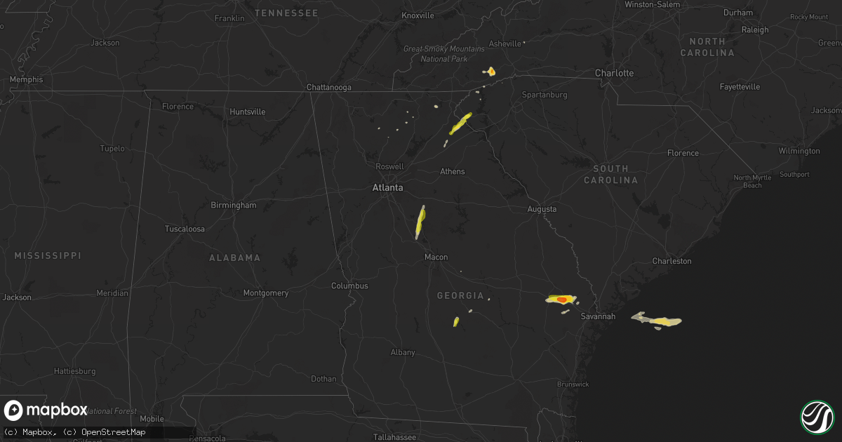
Hail Map on April 9, 2019
Get this storm
April 9 map
$229
one time, instant access
Download today. No call, no setup
Keep the $229
Bought the map and want the full workflow? Apply the entire $229 to a subscription within 7 days. None of it is wasted.
Every map, not just this one
This buys you this map. Subscription and you get every map we run, in the markets you choose from a few cities to whole states to nationwide. Plus real-time alerts the moment a storm fires.
Contact data
Name, contact info, occupancy, even credit band for addresses in the footprint. You go from where it hit to who to call.
Become the source they trust
Unlimited branding weather history reports on demand. You already have the documented answer ready for the property owner, and you are the one who showed up with it.
Property data and RoofTrace estimates
Pull up any address you have got, its value and the exact code rules for that jurisdiction, straight from One Click Code. Then RoofTrace estimates the squares, pitch, and roof value, priced the way you price.
States Impacted by Hail Map on April 9, 2019
Storm reports
Florida
| Date | Description |
|---|---|
| 04/09/20192:25 PM CDT | Numerous trees down in seminole co... From oviedo to near mullet lake. Cross streets include forest trail and s. Lake jesup... Graham ave and hillcrest dr.... Howard av |
| 04/09/20197:21 AM CDT | At 1220 PM EDT, a severe thunderstorm was located over Homestead General Airport, moving east at 25 mph. HAZARD...60 mph wind gusts. SOURCE...Radar indicated. IMPACT...Expect damage to roofs, siding, and trees. Locations impacted include... Homestead, Coral Gables, South Miami, Homestead Miami Speedway and Black Point. |
| 04/08/201911:00 PM CDT | At 359 PM EDT, a severe thunderstorm was located over mainly rural areas of Volusia County, moving northeast at 35 mph. HAZARD...60 mph wind gusts and nickel size hail. SOURCE...Radar indicated. IMPACT...Expect damage to roofs, siding, and trees. Locations impacted include... Port Orange, New Smyrna Beach, Edgewater, Oak Hill and Ponce Inlet. |
| 04/08/201910:33 PM CDT | At 333 PM EDT, a severe thunderstorm was located near Geneva, moving northeast at 30 mph. HAZARD...60 mph wind gusts and quarter size hail. SOURCE...Radar indicated. IMPACT...Hail damage to vehicles is expected. Expect wind damage to roofs, siding, and trees. Locations impacted include... Deltona, Sanford, Oviedo, New Smyrna Beach and Oak Hill. |
New York
| Date | Description |
|---|---|
| 04/09/20191:42 PM CDT | Pine tree snapped on ruffner road |
| 04/09/20191:10 PM CDT | Tractor trailer blow over on i88 between exits 21 and 22. Emergency services were dispatched with no reports of injuries. |
| 04/08/20199:17 PM CDT | At 216 PM EDT, a severe thunderstorm was located over Central Bridge, or 9 miles northeast of Cobleskill, moving east at 50 mph. HAZARD...60 mph wind gusts and nickel size hail. SOURCE...Radar indicated. IMPACT...Expect damage to roofs, siding, and trees. Locations impacted include... Albany, Schenectady, Rotterdam, Scotia, Guilderland, Niskayuna, Duanesburg, Berne, Voorheesville, Altamont, Schoharie, Delanson, East Glenville, Alplaus, Central Bridge, New Scotland, Knox, Princetown, Carlisle and Esperance. |
South Carolina
| Date | Description |
|---|---|
| 04/09/201912:30 PM CDT | Up to quarter sized hail reported at chau ram county park. |
| 04/08/20197:17 PM CDT | Multiple trees reported down on sc 170 in the savannah national wildlife refuge by south carolina highway patrol. Time estimated by radar. |
North Carolina
| Date | Description |
|---|---|
| 04/09/20191:15 PM CDT | Public reported via social media larger than quarter size hail in brevard. |
Georgia
| Date | Description |
|---|---|
| 04/09/20195:55 PM CDT | A social media post from broadcast media shows golf ball size hail. |
| 04/09/20194:57 PM CDT | Quarter-sized hail was reported at the dollar general in abbeville. |
| 04/09/20194:55 PM CDT | Public reported a tree was downed on brantley street nw. |
| 04/09/20194:55 PM CDT | Public reported a tree down on marietta rd nw near dupont commons lane. |
| 04/09/201912:08 PM CDT | Up to quarter sized hail reported by spotter east of toccoa... Ga. |
| 04/09/201912:02 PM CDT | Up to 1 inch hail reported ese of toccoa... Ga. |
| 04/09/201911:30 AM CDT | Report of a tree blown down just ssw of pinefield crossroads |
| 04/09/201911:20 AM CDT | Reports of 2 trees down 2 mi sse of homer |
| 04/09/20199:15 AM CDT | Update: report of 15-20 large trees down with 2 powerlines powerlines also down near the intersection of hwy 36 and fincher rd due to very strong straight line winds. |
| 04/09/20199:15 AM CDT | Reports of multiple trees down on power lines in the stewart glen subdivision |
| 04/09/20198:52 AM CDT | Quarter-sized hail reported at the flovilla fire department |
| 04/09/20197:44 AM CDT | At 1243 PM EDT, a severe thunderstorm was located 8 miles south of Toccoa, or 8 miles west of Avalon, moving northeast at 25 mph. HAZARD...60 mph wind gusts and quarter size hail. SOURCE...Radar indicated. IMPACT...Minor hail damage to vehicles is expected. Expect wind damage to trees and power lines. Locations impacted include... Toccoa, Carnesville, Westminster, Lavonia, Gumlog, Martin, Avalon, Tugaloo State Park, Long Creek and Oakway. |
| 04/09/20197:19 AM CDT | At 1218 PM EDT, a severe thunderstorm was located over Banks Crossing, moving northeast at 25 mph. HAZARD...60 mph wind gusts and quarter size hail. SOURCE...Radar indicated. IMPACT...Hail damage to vehicles is expected. Expect wind damage to roofs, siding, and trees. Locations impacted include... Commerce, Homer, Maysville, Pinefield Crossroads, Hollingsworth and Banks Crossing. |
| 04/09/20195:15 AM CDT | At 1014 AM EDT, a severe thunderstorm was located over North Alcovy, moving north at 30 mph. HAZARD...60 mph wind gusts and quarter size hail. SOURCE...Radar indicated. IMPACT...Hail damage to vehicles is expected. Expect wind damage to roofs, siding, and trees. Locations impacted include... Covington, Social Circle, Oxford, Porterdale, Newborn, Mansfield, Stewart, Turtle Cove, Almon, Starrsville, Brick Store, Calvin, Eudora, North Alcovy and Rocky Plains. |
| 04/09/20194:45 AM CDT | At 945 AM EDT, a severe thunderstorm was located over Flovilla, or near Jackson, moving north at 30 mph. HAZARD...60 mph wind gusts and quarter size hail. SOURCE...Radar indicated. IMPACT...Hail damage to vehicles is expected. Expect wind damage to roofs, siding, and trees. Locations impacted include... Jackson, Monticello, Porterdale, Newborn, Flovilla, Mansfield, Stewart, Turtle Cove, Worthville, Berner, Calvin, Farrar, Blount, Eudora, North Alcovy, McElheneys Crossroads, Juliette, Indian Springs State Park, Fincherville and Stark. |
| 04/09/201912:56 AM CDT | At 556 PM EDT, a severe thunderstorm was located over Abbeville, moving northeast at 25 mph. HAZARD...60 mph wind gusts and quarter size hail. SOURCE...Radar indicated. IMPACT...Hail damage to vehicles is expected. Expect wind damage to roofs, siding, and trees. Locations impacted include... Eastman, Abbeville, Rhine, Chauncey, Union, Jay Bird Springs, Browning, Five Points, Godwinsville, Ocmulgee Banks and Achord. |
| 04/08/20198:27 PM CDT | At 127 PM EDT, a severe thunderstorm was located 5 miles south of Walhalla, or near Westminster, moving northeast at 25 mph. HAZARD...60 mph wind gusts and quarter size hail. SOURCE...Radar indicated. IMPACT...Minor hail damage to vehicles is expected. Expect wind damage to trees and power lines. Locations impacted include... Clemson, Seneca, Walhalla, Central, Westminster, Norris, Six Mile, Salem, Lake Keowee and Oakway. |
Cities Impacted by Hail Map on April 9, 2019
- Abbeville, GA
- Westminster, SC
- Eastanollee, GA
- Toccoa, GA
- Brooklet, GA
- Pembroke, GA
- Register, GA
- Claxton, GA
- Statesboro, GA
- Brevard, NC
- Geneva, FL
- Osteen, FL
- Oviedo, FL
- New Smyrna Beach, FL
- Ellabell, GA
- Covington, GA
- Forsyth, GA
- Monticello, GA
- Flovilla, GA
- Jackson, GA
- Dawsonville, GA
- Marble Hill, GA
- Howes Cave, NY
- Balsam Grove, NC
- Pisgah Forest, NC
- Commerce, GA
- Maysville, GA
- Homer, GA
- Guyton, GA
- Glenwood, GA
- Dahlonega, GA
- Ball Ground, GA
- Jasper, GA
- Esperance, NY
- Schoharie, NY
- Central Bridge, NY
- Suches, GA
- Lower Brule, SD
- Clarkesville, GA
- Talking Rock, GA
- Fort Stewart, GA
- Chauncey, GA
- Mansfield, GA
- Baldwin, GA
- Walhalla, SC
- Edgewater, FL