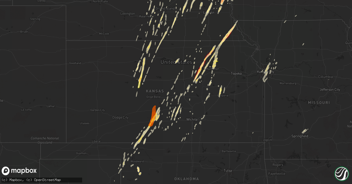
Hail Map in Kansas on April 9, 2013
Get this storm
April 9 map
$229
one time, instant access
Download today. No call, no setup
Keep the $229
Bought the map and want the full workflow? Apply the entire $229 to a subscription within 7 days. None of it is wasted.
Every map, not just this one
This buys you this map. Subscription and you get every map we run, in the markets you choose from a few cities to whole states to nationwide. Plus real-time alerts the moment a storm fires.
Contact data
Name, contact info, occupancy, even credit band for addresses in the footprint. You go from where it hit to who to call.
Become the source they trust
Unlimited branding weather history reports on demand. You already have the documented answer ready for the property owner, and you are the one who showed up with it.
Property data and RoofTrace estimates
Pull up any address you have got, its value and the exact code rules for that jurisdiction, straight from One Click Code. Then RoofTrace estimates the squares, pitch, and roof value, priced the way you price.
Storm reports in Kansas
Kansas
| Date | Description |
|---|---|
| 04/09/20136:00 PM CDT | Half dollar size hail. |
| 04/09/20136:00 PM CDT | Nickel to quarter size hail in westmoreland. |
| 04/09/20135:43 PM CDT | A local report indicates 1.00 inch wind near HAYS |
| 04/09/20135:38 PM CDT | A local report indicates 1.75 inch wind near 2 S HAYS |
| 04/09/20135:28 PM CDT | Lots of quarter size hail. |
| 04/09/20135:24 PM CDT | Only a few hail stones but they were around quarter size. |
| 04/09/20135:15 PM CDT | A local report indicates 1.00 inch wind near 3 WNW RANDOLPH |
| 04/09/20135:04 PM CDT | A local report indicates 1.00 inch wind near 5 N CATHERINE |
| 04/09/20134:46 PM CDT | Courtesy of social media photo. Time estimated based on radar. |
| 04/09/20134:42 PM CDT | A local report indicates 1.75 inch wind near 4 S WAKEFIELD |
| 04/09/20134:35 PM CDT | The hail was mostly dime to nickel size. |
| 04/09/20134:30 PM CDT | A local report indicates 1.00 inch wind near 7 N MOONLIGHT |
| 04/09/20134:20 PM CDT | A local report indicates 1.25 inch wind near 3 N ENTERPRISE |
| 04/09/20134:16 PM CDT | Along jeep road east of abilene...hail not quite as big as a golfball but larger than a quarter. |
| 04/09/20134:15 PM CDT | A local report indicates 1.00 inch wind near ESE ABILENE |
| 04/09/20132:45 PM CDT | Hail up to the size of ping pong balls fell around 245 pm and lasted for about 5 minutes |
| 04/08/201310:45 PM CDT | A local report indicates 1.00 inch wind near AMERICUS |
| 04/08/201310:41 PM CDT | A local report indicates 1.25 inch wind near AMERICUS |
| 04/08/201310:21 PM CDT | A local report indicates 1.00 inch wind near 6 E ABILENE |
| 04/08/20138:38 PM CDT | Courtesy of spotter network |
| 04/08/20138:12 PM CDT | A local report indicates 1.00 inch wind near 1 W LYONS |
| 04/08/20137:45 PM CDT | A local report indicates 1.00 inch wind near S STAFFORD |
| 04/08/20137:43 PM CDT | Law enforcement reported that the hail was 2 to 3 inches deep on the roads from stafford to the junction of highway 50 and highway 281. |
| 04/08/20137:40 PM CDT | A local report indicates 1.75 inch wind near 2 SSW IUKA |
| 04/08/20137:40 PM CDT | A local report indicates 1.00 inch wind near STAFFORD |
| 04/08/20137:15 PM CDT | A local report indicates 1.00 inch wind near 3 WNW COATS |
| 04/08/20137:11 PM CDT | A local report indicates 1.00 inch wind near 3 WNW COATS |
| 04/08/20137:08 PM CDT | A local report indicates 1.50 inch wind near 7 N PRATT |
All States Impacted by Hail Map on April 9, 2013
Cities Impacted by Hail Map on April 9, 2013
- Kansas City, MO
- Sterling, KS
- Olney, TX
- Westmoreland, KS
- Pawnee City, NE
- Table Rock, NE
- Humboldt, NE
- Fullerton, NE
- Genoa, NE
- Silver Creek, NE
- Missouri Valley, IA
- Randolph, KS
- Leonardville, KS
- Abilene, KS
- Throckmorton, TX
- Windthorst, TX
- Henrietta, TX
- Milton, KS
- Wakefield, KS
- Hutchinson, KS
- Partridge, KS
- Fort Calhoun, NE
- Blue Rapids, KS
- Pratt, KS
- Turon, KS
- Juniata, NE
- Hastings, NE
- Boys Town, NE
- Omaha, NE
- Gretna, NE
- Springfield, NE
- Woodston, KS
- Mabel, MN
- Cresco, IA
- Canton, MN
- Decorah, IA
- Harmony, MN
- Clay Center, KS
- Waterville, KS
- Riley, KS
- Chapman, KS
- Frankfort, KS
- Marysville, KS
- Home, KS
- Newcastle, TX
- Milford, NE
- Olsburg, KS
- Magnolia, IA
- Mondamin, IA
- Logan, IA
- Modale, IA
- Fair Grove, MO
- Strafford, MO
- Rush Center, KS
- Nekoma, KS
- Rotan, TX
- Shelton, NE
- Canton, KS
- Linwood, NE
- Humboldt, IA
- Manson, IA
- Gilmore City, IA
- Rockwell City, IA
- Clare, IA
- Palmer, IA
- Coldwater, KS
- Alva, OK
- Pender, NE
- Seward, NE
- Bee, NE
- Valparaiso, NE
- Garland, NE
- Dwight, NE
- Humphrey, NE
- Lindsay, NE
- Minden, NE
- Riverton, NE
- Campbell, NE
- Smith Center, KS
- Athol, KS
- Gaylord, KS
- Kensington, KS
- Cedar, KS
- Sioux City, IA
- Lawton, IA
- Sergeant Bluff, IA
- Benedict, NE
- Stromsburg, NE
- York, NE
- Iuka, KS
- Emerson, NE
- Allen, NE
- Wakefield, NE
- Vici, OK
- Liebenthal, KS
- La Crosse, KS
- Gibbon, NE
- Webb, IA
- Madison, NE
- Saint Edward, NE
- Monroe, NE
- Baileyville, KS
- Bloomington, NE
- Naponee, NE
- Murdock, NE
- Alvo, NE
- Elmwood, NE
- Stacyville, IA
- Little Cedar, IA
- Osage, IA
- Machesney Park, IL
- Roscoe, IL
- Rockford, IL
- Council Bluffs, IA
- Axtell, KS
- Excelsior Springs, MO
- Caldwell, KS
- Moorhead, IA
- Aurelia, IA
- Cherokee, IA
- Wahoo, NE
- Sioux Rapids, IA
- Greenville, IA
- McIntire, IA
- Leedey, OK
- Clyde, TX
- Hermleigh, TX
- Snyder, TX
- Dickens, IA
- Spencer, IA
- Bellevue, NE
- Carter Lake, IA
- Papillion, NE
- Wayne, NE
- Manhattan, KS
- Ute, IA
- Laverne, OK
- Shattuck, OK
- Kenesaw, NE
- Holstein, NE
- Bennington, NE
- Kennard, NE
- Concordia, KS
- Glasco, KS
- Beloit, KS
- Simpson, KS
- Red Cloud, NE
- Guide Rock, NE
- Blue Hill, NE
- Burr Oak, KS
- Lawrence, NE
- Esbon, KS
- Glenvil, NE
- Lebanon, KS
- Portis, KS
- Fairfield, NE
- Danbury, IA
- Holstein, IA
- Battle Creek, IA
- Enterprise, KS
- Stilwell, KS
- Grandview, MO
- Belton, MO
- Holliday, TX
- Longford, KS
- Preston, MN
- Lanesboro, MN
- Isabel, KS
- Medicine Lodge, KS
- Sawyer, KS
- Columbus, NE
- Ravenna, NE
- Saint George, KS
- Coats, KS
- Sun City, KS
- Stafford, KS
- Wilmore, KS
- North Bend, NE
- Scribner, NE
- Nickerson, KS
- Abbyville, KS
- Sharon, OK
- Superior, NE
- St John, KS
- Lincoln, NE
- Raymond, NE
- Ceresco, NE
- Davey, NE
- Chester, IA
- Saint Ansgar, IA
- Riceville, IA
- Le Roy, MN
- Hays, KS
- Agra, KS
- Phillipsburg, KS
- Glade, KS
- Solomon, KS
- Wellington, KS
- Junction City, KS
- Loup City, NE
- Americus, KS
- Council Grove, KS
- Allen, KS
- Cedar Bluffs, NE
- Ames, NE
- Malmo, NE
- Fremont, NE
- Hooper, NE
- Peru, NE
- Auburn, NE
- Du Bois, NE
- Brownville, NE
- Cedar Falls, IA
- Denver, IA
- Dike, IA
- Grundy Center, IA
- Janesville, IA
- Morse Bluff, NE
- Schuyler, NE
- David City, NE
- Dodge, NE
- Rogers, NE
- Camargo, OK
- Augusta, KS
- El Dorado, KS
- Little River, KS
- Buffalo, OK
- Beattie, KS
- Decatur, NE
- Onawa, IA
- Plainville, KS
- Neola, IA
- Crescent, IA
- Honey Creek, IA
- Rockville, NE
- Wood River, NE
- Soldier, IA
- Castana, IA
- Lake City, KS
- Waverly, NE
- Sutton, NE
- Saronville, NE
- Clay Center, NE
- Harvard, NE
- Freedom, OK
- Arlington, NE
- Blair, NE
- Charter Oak, IA
- Dunlap, IA
- Hallam, NE
- Crete, NE
- Houston, MN
- Caledonia, MN
- Gypsum, KS
- Kingman, KS
- South Hutchinson, KS
- Arlington, KS
- Pretty Prairie, KS
- Holland, IA
- New Hartford, IA
- Surprise, NE
- Utica, NE
- Rising City, NE
- Gresham, NE
- Ulysses, NE
- Bellwood, NE
- Roseland, NE
- Bladen, NE
- Carroll, NE
- Winside, NE
- Elmdale, KS
- Cedar Point, KS
- Cunningham, KS
- Marshfield, MO
- Springfield, MO
- North Sioux City, SD
- Hubbard, NE
- Jackson, NE
- Dakota City, NE
- South Sioux City, NE
- Shamrock, TX
- Wheeler, TX
- Albion, NE
- Ashland, NE
- Aurora, NE
- Edgar, NE
- McCune, KS
- Oswego, KS
- Dwight, KS
- White City, KS
- Milford, KS
- Abilene, TX
- Galva, IA
- Rose Hill, KS
- Douglass, KS
- Mayfield, KS
- Winslow, NE
- Craig, NE
- Herman, NE
- Archer, NE
- Central City, NE
- Palmer, NE
- Sibley, MO
- Orrick, MO
- Garner, IA
- Goodell, IA
- Trumbull, NE
- Doniphan, NE
- Bronte, TX
- Alton, KS
- Stanton, NE
- Waterbury, NE
- Norfolk, NE
- Pilger, NE
- Hoskins, NE
- Robert Lee, TX
- Winters, TX
- Wingate, TX
- Valley Center, KS
- Blackwell, TX
- Wilsey, KS
- Quimby, IA
- Laurel, NE
- Alta, IA
- Mcpherson, KS
- Higgins, TX
- Arnett, OK
- Mapleton, IA
- Dow City, IA
- Columbia, MO
- Hinton, IA
- Merrill, IA
- Wolbach, NE
- Comstock, NE
- Westerville, NE
- Broken Bow, NE
- Ansley, NE
- Kearney, MO
- Liberty, MO
- Sweetwater, TX
- Roby, TX
- Sylvia, KS
- Raymond, KS
- Hope, KS
- Belle Plaine, KS
- Mulvane, KS
- Tuscola, TX
- Ovalo, TX
- Cedar Rapids, NE
- Catharine, KS
- Natoma, KS
- Linn, KS
- McCracken, KS
- Le Mars, IA
- Rushford, MN
- Peterson, MN
- Spring Grove, MN
- Sargent, NE
- Burwell, NE
- Zenda, KS
- Attica, KS
- Oakland, NE
- West Point, NE
- Aurora, KS
- Fontana, WI
- Lake Geneva, WI
- Walworth, WI
- O'Brien, TX
- Old Glory, TX
- Seymour, TX
- Thurston, NE
- Goldfield, IA
- Ackley, IA
- Iowa Falls, IA
- Haven, KS
- Burrton, KS
- Inman, KS
- Burchard, NE
- Alta Vista, KS
- La Vista, NE
- Emporia, KS
- Hokah, MN
- La Crescent, MN
- Lime Springs, IA
- Spring Valley, MN
- Stratford, IA
- Marquette, NE
- Funk, NE
- Kearney, NE
- Ellis, KS
- Hampton, NE
- Bruno, NE
- Prague, NE
- Waco, NE
- Burdick, KS
- La Crosse, WI
- Boone, IA
- Stockton, KS
- Kirwin, KS
- Scotland, TX
- Salina, KS
- Brookville, KS
- Ruthven, IA
- Nickerson, NE
- Victoria, KS
- Greenleaf, KS
- Washington, KS
- Blythedale, MO
- Caledonia, IL
- Winnebago, IL
- Poplar Grove, IL
- Loves Park, IL
- Leawood, KS
- Prairie Village, KS
- Kansas City, KS
- Overland Park, KS
- Lyons, KS
- Bradshaw, NE
- Henderson, NE
- Assaria, KS
- Buhler, KS
- Stanhope, IA
- Pilot Mound, IA
- Deweese, NE
- Ayrshire, IA
- Elkhorn, NE
- De Witt, NE
- Clatonia, NE
- Fort Dodge, IA
- Ayr, NE
- Alda, NE
- Grand Island, NE
- Allerton, IA
- Plattsburg, MO
- Cheney, KS
- Readlyn, IA
- Kingsley, IA
- Turney, MO
- Lathrop, MO
- Platte Center, NE
- Creston, NE
- Osborne, KS
- Elma, IA
- Peterson, IA
- Linn Grove, IA
- Florence, KS
- Primrose, NE
- Lindsborg, KS
- Galva, KS
- Canadian, TX
- Briscoe, TX
- Morrowville, KS
- Ellsworth, KS
- Kanopolis, KS
- Geneseo, KS
- Tripoli, IA
- Durham, OK
- Inavale, NE
- Palmyra, NE
- Louisville, NE
- Taopi, MN
- Remsen, IA
- Admire, KS
- Newman Grove, NE
- Paradise, KS
- Nelson, NE
- Schoenchen, KS
- Cairo, NE
- Dannebrog, NE
- May, OK
- McCool Junction, NE
- Tescott, KS
- Sumner, IA
- Reinbeck, IA
- Waverly, IA
- Parkersburg, IA
- Waterloo, IA
- Gorham, KS
- Badger, IA
- Protection, KS
- Jansen, NE
- Beatrice, NE
- Plymouth, NE
- Woodbine, IA
- Pisgah, IA
- Roscoe, TX
- Clyde, KS
- Ponca, NE
- Sedgwick, KS
- Purdin, MO
- Linneus, MO
- Independence, MO
- Denton, NE
- Early, IA
- Odebolt, IA
- Arthur, IA
- Shelby, NE
- Osceola, NE
- Woodson, TX
- Minneapolis, KS
- Plattsmouth, NE
- Murdock, KS
- Kanawha, IA
- Martell, NE
- Fargo, OK
- Haviland, KS
- Seneca, KS
- Durham, KS
- Wilber, NE
- Strong City, KS
- Mount Hope, KS
- Saint Libory, NE
- Abie, NE
- Lipscomb, TX
- Woodbine, KS
- Lawson, MO
- Rayville, MO
- Harvard, IL
- Sharon, WI
- Capron, IL
- Alma, NE
- Vincent, IA
- Windom, KS
- Rock Port, MO
- Vermillion, KS
- Watson, MO
- Nashville, KS
- Marcus, IA
- Derby, KS
- Lyons, NE
- Clifton, KS
- Morganville, KS
- Greeley, NE
- Hollenberg, KS
- Thor, IA
- Follett, TX
- Hazard, NE
- Spivey, KS
- Colon, NE
- Ithaca, NE
- Mead, NE
- Diller, NE
- Ida Grove, IA
- Aspermont, TX
- Bellevue, TX
- Jacksboro, TX
- Loving, TX
- Electra, TX
- Grandfield, OK
- Iowa Park, TX
- Livermore, IA
- Rutland, IA
- Dunkerton, IA
- Schleswig, IA
- Ricketts, IA
- Ostrander, MN
- Adams, MN
- Byers, KS
- Macksville, KS


