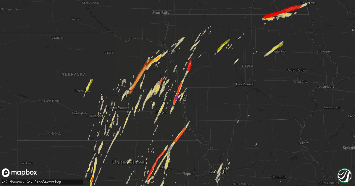
Hail Map on April 9, 2013
Get this storm
April 9 map
$229
one time, instant access
Download today. No call, no setup
Keep the $229
Bought the map and want the full workflow? Apply the entire $229 to a subscription within 7 days. None of it is wasted.
Every map, not just this one
This buys you this map. Subscription and you get every map we run, in the markets you choose from a few cities to whole states to nationwide. Plus real-time alerts the moment a storm fires.
Contact data
Name, contact info, occupancy, even credit band for addresses in the footprint. You go from where it hit to who to call.
Become the source they trust
Unlimited branding weather history reports on demand. You already have the documented answer ready for the property owner, and you are the one who showed up with it.
Property data and RoofTrace estimates
Pull up any address you have got, its value and the exact code rules for that jurisdiction, straight from One Click Code. Then RoofTrace estimates the squares, pitch, and roof value, priced the way you price.
States Impacted by Hail Map on April 9, 2013
Storm reports
Illinois
| Date | Description |
|---|---|
| 04/09/20136:40 AM CDT | Multiple semis either jackknifed or flipped onto their side along interstate 39 in southeast ogle county. Southbound lanes are closed. Time is estimated based on radar |
| 04/09/20136:10 AM CDT | A local report indicates 67 MPH wind near 2 SSE ROCK FALLS |
Kansas
| Date | Description |
|---|---|
| 04/09/20136:00 PM CDT | Nickel to quarter size hail in westmoreland. |
| 04/09/20136:00 PM CDT | Half dollar size hail. |
| 04/09/20135:43 PM CDT | A local report indicates 1.00 inch wind near HAYS |
| 04/09/20135:38 PM CDT | A local report indicates 1.75 inch wind near 2 S HAYS |
| 04/09/20135:28 PM CDT | Lots of quarter size hail. |
| 04/09/20135:24 PM CDT | Only a few hail stones but they were around quarter size. |
| 04/09/20135:15 PM CDT | A local report indicates 1.00 inch wind near 3 WNW RANDOLPH |
| 04/09/20135:04 PM CDT | A local report indicates 1.00 inch wind near 5 N CATHERINE |
| 04/09/20134:46 PM CDT | Courtesy of social media photo. Time estimated based on radar. |
| 04/09/20134:42 PM CDT | A local report indicates 1.75 inch wind near 4 S WAKEFIELD |
| 04/09/20134:35 PM CDT | The hail was mostly dime to nickel size. |
| 04/09/20134:30 PM CDT | A local report indicates 1.00 inch wind near 7 N MOONLIGHT |
| 04/09/20134:20 PM CDT | A local report indicates 1.25 inch wind near 3 N ENTERPRISE |
| 04/09/20134:16 PM CDT | Along jeep road east of abilene...hail not quite as big as a golfball but larger than a quarter. |
| 04/09/20134:15 PM CDT | A local report indicates 1.00 inch wind near ESE ABILENE |
| 04/09/20132:45 PM CDT | Hail up to the size of ping pong balls fell around 245 pm and lasted for about 5 minutes |
| 04/08/201310:45 PM CDT | A local report indicates 1.00 inch wind near AMERICUS |
| 04/08/201310:41 PM CDT | A local report indicates 1.25 inch wind near AMERICUS |
| 04/08/201310:21 PM CDT | A local report indicates 1.00 inch wind near 6 E ABILENE |
| 04/08/20138:38 PM CDT | Courtesy of spotter network |
| 04/08/20138:12 PM CDT | A local report indicates 1.00 inch wind near 1 W LYONS |
| 04/08/20137:45 PM CDT | A local report indicates 1.00 inch wind near S STAFFORD |
| 04/08/20137:43 PM CDT | Law enforcement reported that the hail was 2 to 3 inches deep on the roads from stafford to the junction of highway 50 and highway 281. |
| 04/08/20137:40 PM CDT | A local report indicates 1.75 inch wind near 2 SSW IUKA |
| 04/08/20137:40 PM CDT | A local report indicates 1.00 inch wind near STAFFORD |
| 04/08/20137:15 PM CDT | A local report indicates 1.00 inch wind near 3 WNW COATS |
| 04/08/20137:11 PM CDT | A local report indicates 1.00 inch wind near 3 WNW COATS |
| 04/08/20137:08 PM CDT | A local report indicates 1.50 inch wind near 7 N PRATT |
Wisconsin
| Date | Description |
|---|---|
| 04/08/20139:35 PM CDT | A local report indicates 1.00 inch wind near 3 SSE LA CROSSE |
| 04/08/20139:35 PM CDT | A local report indicates 1.00 inch wind near 1 SSW LA CROSSE |
| 04/08/20139:27 PM CDT | A local report indicates 1.00 inch wind near 1 SE LA CROSSE |
Minnesota
| Date | Description |
|---|---|
| 04/08/20139:00 PM CDT | A local report indicates 1.00 inch wind near 3 SE HOUSTON |
| 04/08/20138:42 PM CDT | A local report indicates 1.25 inch wind near HARMONY |
| 04/08/20138:32 PM CDT | A local report indicates 1.00 inch wind near 2 ESE HUTTON |
| 04/08/20138:28 PM CDT | Ping pong size hail |
Iowa
| Date | Description |
|---|---|
| 04/09/20135:53 PM CDT | A local report indicates 1.00 inch wind near HUMBOLDT |
| 04/09/20135:46 PM CDT | Quarter size hail along highway 3 |
| 04/09/20135:42 PM CDT | Hail covering the ground. Up to quarter size. |
| 04/09/20135:15 PM CDT | Hail covering the ground. Largest up to quarters. Lasted for two to three minutes. |
| 04/09/20134:40 PM CDT | A local report indicates 1.00 inch wind near HINTON |
| 04/09/20139:40 AM CDT | Relayed by kcrg tv |
| 04/09/20139:19 AM CDT | Time estimated from radar. |
| 04/09/20137:58 AM CDT | Hail the size of a quarter to half dollar. |
| 04/08/20139:20 PM CDT | A local report indicates 2.00 inch wind near 2 S CHARTER OAK |
| 04/08/20139:15 PM CDT | Large pine tree blown over onto to valley avenue |
| 04/08/20139:12 PM CDT | A local report indicates 68 MPH wind near CRESCO |
| 04/08/20139:12 PM CDT | Both a pickup and a semi was blown over. Both vehicles were hauling an empty cattle trailer. |
| 04/08/20139:11 PM CDT | Garage roof blown off |
| 04/08/20139:05 PM CDT | Storage shed blown over |
| 04/08/20138:55 PM CDT | A local report indicates 1.00 inch wind near MAGNOLIA |
| 04/08/20138:02 PM CDT | A local report indicates 1.00 inch wind near 3 N BURT |
| 04/08/20137:59 PM CDT | Farm barn...or outbuilding...destroyed |
| 04/08/20137:45 PM CDT | Power line down |
| 04/08/20137:45 PM CDT | Ping pong size hail |
| 04/08/20137:36 PM CDT | Pea to quarter size |
| 04/08/20137:36 PM CDT | Gof ball size hail |
| 04/08/20137:15 PM CDT | Delayed report from last night. Athletic equipment shed and baseball field dugout at laurens-marathon school destroyed. At least four trees and multiple large branches |
| 04/08/20137:14 PM CDT | Shed blown over |
Nebraska
| Date | Description |
|---|---|
| 04/09/20136:55 PM CDT | A local report indicates 1.00 inch wind near 3 NNW NORTH BEND |
| 04/09/20136:51 PM CDT | A local report indicates 1.25 inch wind near HUMBOLDT |
| 04/09/20136:50 PM CDT | Windows broken in police car. |
| 04/09/20136:50 PM CDT | A local report indicates 1.75 inch wind near 3 W HUMBOLDT |
| 04/09/20136:48 PM CDT | A local report indicates 1.00 inch wind near 1 W HUMBOLDT |
| 04/09/20136:32 PM CDT | A local report indicates 1.00 inch wind near VALPARAISO |
| 04/09/20136:30 PM CDT | Did damage to house siding. |
| 04/09/20136:24 PM CDT | A local report indicates 1.25 inch wind near 3 N LINCOLN |
| 04/09/20135:45 PM CDT | Mostly nickel size with a few quarters. |
| 04/09/20134:45 PM CDT | A local report indicates 1.00 inch wind near CARROLL |
| 04/09/20133:47 PM CDT | A local report indicates 1.00 inch wind near WAYNE |
| 04/09/20133:46 PM CDT | A local report indicates 1.00 inch wind near WAYNE |
| 04/09/20133:45 PM CDT | A local report indicates 1.75 inch wind near WAKEFIELD |
| 04/09/20133:38 PM CDT | A local report indicates 1.50 inch wind near WAYNE |
| 04/09/20133:10 PM CDT | A local report indicates 1.00 inch wind near CEDAR RAPIDS |
| 04/09/20133:00 PM CDT | A local report indicates 1.00 inch wind near MADISON |
| 04/09/20132:45 PM CDT | A local report indicates 1.00 inch wind near 4 E SARGENT |
| 04/09/20132:44 PM CDT | A local report indicates 1.25 inch wind near CORNLEA |
| 04/09/20132:28 PM CDT | Mostly pea size...but severe quarter size stones as well. Ground covered. |
| 04/09/20132:26 PM CDT | A local report indicates 1.00 inch wind near 1 S WEISSERT |
| 04/09/20132:10 PM CDT | Pea size to quarter size hail. Hail completely covering ground. |
| 04/08/20138:43 PM CDT | A local report indicates 1.75 inch wind near FORT CALHOUN |
| 04/08/20138:40 PM CDT | 120th and center |
| 04/08/20138:38 PM CDT | 114th and fort |
| 04/08/20138:30 PM CDT | Mostly quarter size to golfball size...but some up to tennis ball size. The largest hail was soft on the outside edges. Near 108th street and rainwood road. |
| 04/08/20138:30 PM CDT | 132 and dodge |
| 04/08/20138:27 PM CDT | 120th and maple in omaha |
| 04/08/20138:27 PM CDT | A local report indicates 1.00 inch wind near 1 N BOYS TOWN |
| 04/08/20138:26 PM CDT | 168th and q. |
| 04/08/20138:26 PM CDT | 150th and binney |
| 04/08/20138:25 PM CDT | 176th and q street |
| 04/08/20138:25 PM CDT | 150th and giles. |
| 04/08/20138:25 PM CDT | 132 and dodge...cars dented with hail covering the ground |
| 04/08/20138:24 PM CDT | 177th and center. |
| 04/08/20138:24 PM CDT | 144th and center |
| 04/08/20138:23 PM CDT | A local report indicates 2.00 inch wind near 10 SW OMAHA |
| 04/08/20138:22 PM CDT | 156th and f. |
| 04/08/20138:20 PM CDT | Hail accumulated to 2 inches...hail ranged from 1-2 inches |
| 04/08/20138:20 PM CDT | Near 161st and harrison. |
| 04/08/20138:19 PM CDT | A local report indicates 1.25 inch wind near 10 SW OMAHA |
| 04/08/20138:17 PM CDT | A local report indicates 1.50 inch wind near 4 E GRETNA |
| 04/08/20137:15 PM CDT | A local report indicates 1.00 inch wind near 3 E AUBURN |
Missouri
| Date | Description |
|---|---|
| 04/08/201310:22 PM CDT | Nickel to quarter size |
Texas
| Date | Description |
|---|---|
| 04/09/20136:57 PM CDT | Sheriff office reported golf ball size hail. |
| 04/09/20136:42 PM CDT | Still upto golfball sized hail |
| 04/09/20136:42 PM CDT | Golf ball size hail still falling. |
| 04/09/20136:40 PM CDT | Us 380 and highway 22 to haskell throckmorton countyline |
| 04/09/20136:40 PM CDT | Us 380 and highway 22 to haskell and throckmorton county line |
| 04/09/20135:40 PM CDT | A local report indicates 1.00 inch wind near 3 N RED SPRINGS |
| 04/09/20132:55 AM CDT | Dime to quarter size hail |
| 04/08/201311:55 PM CDT | A local report indicates 1.00 inch wind near BENJAMIN |
| 04/08/20139:35 PM CDT | A local report indicates 1.00 inch wind near KAMAY |
| 04/08/20139:29 PM CDT | A local report indicates 1.00 inch wind near 5 SW DEER CREEK |
| 04/08/20138:29 PM CDT | A local report indicates 1.00 inch wind near BLUEGROVE |
| 04/08/20138:21 PM CDT | A local report indicates 2.00 inch wind near 3 E WINDTHORST |
| 04/08/20138:20 PM CDT | A local report indicates 1.00 inch wind near 1 W DEER CREEK |
| 04/08/20138:17 PM CDT | A local report indicates 2.00 inch wind near ELBERT |
| 04/08/20138:09 PM CDT | A local report indicates 1.00 inch wind near WINDTHORST |
| 04/08/20138:07 PM CDT | A local report indicates 1.75 inch wind near 4 S WINDTHORST |
| 04/08/20137:33 PM CDT | A local report indicates 2.75 inch wind near 14 SSW ARCHER CITY |
| 04/08/20137:31 PM CDT | Golfball hail in olney |
| 04/08/20137:30 PM CDT | Tennis ball sized hail reported in olney |
| 04/08/20137:28 PM CDT | Ping pong ball size hail 4wsw olney |
| 04/08/20137:25 PM CDT | Golfball hail 3.5wsw olney |
| 04/08/20137:25 PM CDT | Golfball hail at the olney airport |
| 04/08/20137:24 PM CDT | Walnut hail 6s of megargel covering most of the ground |
| 04/08/20137:11 PM CDT | A local report indicates 2.00 inch wind near 1 E ELBERT |
Oklahoma
| Date | Description |
|---|---|
| 04/09/201312:56 AM CDT | A local report indicates 1.00 inch wind near 5 N MEDICINE PARK |
| 04/09/201312:00 AM CDT | A local report indicates 1.00 inch wind near 12 NNW OKARCHE |
| 04/08/201310:05 PM CDT | A local report indicates 1.25 inch wind near GRANDFIELD |
| 04/08/201310:01 PM CDT | A local report indicates 1.00 inch wind near GRANDFIELD |
| 04/08/20139:52 PM CDT | A local report indicates 1.75 inch wind near 6 SW GRANDFIELD |
| 04/08/20138:23 PM CDT | Also freezing rain. |
| 04/08/20138:21 PM CDT | A local report indicates 1.75 inch wind near VICI |
Cities Impacted by Hail Map on April 9, 2013
- Kansas City, MO
- Sterling, KS
- Olney, TX
- Westmoreland, KS
- Pawnee City, NE
- Table Rock, NE
- Humboldt, NE
- Fullerton, NE
- Genoa, NE
- Silver Creek, NE
- Missouri Valley, IA
- Randolph, KS
- Leonardville, KS
- Abilene, KS
- Throckmorton, TX
- Windthorst, TX
- Henrietta, TX
- Milton, KS
- Wakefield, KS
- Hutchinson, KS
- Partridge, KS
- Fort Calhoun, NE
- Blue Rapids, KS
- Pratt, KS
- Turon, KS
- Juniata, NE
- Hastings, NE
- Boys Town, NE
- Omaha, NE
- Gretna, NE
- Springfield, NE
- Woodston, KS
- Mabel, MN
- Cresco, IA
- Canton, MN
- Decorah, IA
- Harmony, MN
- Clay Center, KS
- Waterville, KS
- Riley, KS
- Chapman, KS
- Frankfort, KS
- Marysville, KS
- Home, KS
- Newcastle, TX
- Milford, NE
- Olsburg, KS
- Magnolia, IA
- Mondamin, IA
- Logan, IA
- Modale, IA
- Fair Grove, MO
- Strafford, MO
- Rush Center, KS
- Nekoma, KS
- Rotan, TX
- Shelton, NE
- Canton, KS
- Linwood, NE
- Humboldt, IA
- Manson, IA
- Gilmore City, IA
- Rockwell City, IA
- Clare, IA
- Palmer, IA
- Coldwater, KS
- Alva, OK
- Pender, NE
- Seward, NE
- Bee, NE
- Valparaiso, NE
- Garland, NE
- Dwight, NE
- Humphrey, NE
- Lindsay, NE
- Minden, NE
- Riverton, NE
- Campbell, NE
- Smith Center, KS
- Athol, KS
- Gaylord, KS
- Kensington, KS
- Cedar, KS
- Sioux City, IA
- Lawton, IA
- Sergeant Bluff, IA
- Benedict, NE
- Stromsburg, NE
- York, NE
- Iuka, KS
- Emerson, NE
- Allen, NE
- Wakefield, NE
- Vici, OK
- Liebenthal, KS
- La Crosse, KS
- Gibbon, NE
- Webb, IA
- Madison, NE
- Saint Edward, NE
- Monroe, NE
- Baileyville, KS
- Bloomington, NE
- Naponee, NE
- Murdock, NE
- Alvo, NE
- Elmwood, NE
- Stacyville, IA
- Little Cedar, IA
- Osage, IA
- Machesney Park, IL
- Roscoe, IL
- Rockford, IL
- Council Bluffs, IA
- Axtell, KS
- Excelsior Springs, MO
- Caldwell, KS
- Moorhead, IA
- Aurelia, IA
- Cherokee, IA
- Wahoo, NE
- Sioux Rapids, IA
- Greenville, IA
- McIntire, IA
- Leedey, OK
- Clyde, TX
- Hermleigh, TX
- Snyder, TX
- Dickens, IA
- Spencer, IA
- Bellevue, NE
- Carter Lake, IA
- Papillion, NE
- Wayne, NE
- Manhattan, KS
- Ute, IA
- Laverne, OK
- Shattuck, OK
- Kenesaw, NE
- Holstein, NE
- Bennington, NE
- Kennard, NE
- Concordia, KS
- Glasco, KS
- Beloit, KS
- Simpson, KS
- Red Cloud, NE
- Guide Rock, NE
- Blue Hill, NE
- Burr Oak, KS
- Lawrence, NE
- Esbon, KS
- Glenvil, NE
- Lebanon, KS
- Portis, KS
- Fairfield, NE
- Danbury, IA
- Holstein, IA
- Battle Creek, IA
- Enterprise, KS
- Stilwell, KS
- Grandview, MO
- Belton, MO
- Holliday, TX
- Longford, KS
- Preston, MN
- Lanesboro, MN
- Isabel, KS
- Medicine Lodge, KS
- Sawyer, KS
- Columbus, NE
- Ravenna, NE
- Saint George, KS
- Coats, KS
- Sun City, KS
- Stafford, KS
- Wilmore, KS
- North Bend, NE
- Scribner, NE
- Nickerson, KS
- Abbyville, KS
- Sharon, OK
- Superior, NE
- St John, KS
- Lincoln, NE
- Raymond, NE
- Ceresco, NE
- Davey, NE
- Chester, IA
- Saint Ansgar, IA
- Riceville, IA
- Le Roy, MN
- Hays, KS
- Agra, KS
- Phillipsburg, KS
- Glade, KS
- Solomon, KS
- Wellington, KS
- Junction City, KS
- Loup City, NE
- Americus, KS
- Council Grove, KS
- Allen, KS
- Cedar Bluffs, NE
- Ames, NE
- Malmo, NE
- Fremont, NE
- Hooper, NE
- Peru, NE
- Auburn, NE
- Du Bois, NE
- Brownville, NE
- Cedar Falls, IA
- Denver, IA
- Dike, IA
- Grundy Center, IA
- Janesville, IA
- Morse Bluff, NE
- Schuyler, NE
- David City, NE
- Dodge, NE
- Rogers, NE
- Camargo, OK
- Augusta, KS
- El Dorado, KS
- Little River, KS
- Buffalo, OK
- Beattie, KS
- Decatur, NE
- Onawa, IA
- Plainville, KS
- Neola, IA
- Crescent, IA
- Honey Creek, IA
- Rockville, NE
- Wood River, NE
- Soldier, IA
- Castana, IA
- Lake City, KS
- Waverly, NE
- Sutton, NE
- Saronville, NE
- Clay Center, NE
- Harvard, NE
- Freedom, OK
- Arlington, NE
- Blair, NE
- Charter Oak, IA
- Dunlap, IA
- Hallam, NE
- Crete, NE
- Houston, MN
- Caledonia, MN
- Gypsum, KS
- Kingman, KS
- South Hutchinson, KS
- Arlington, KS
- Pretty Prairie, KS
- Holland, IA
- New Hartford, IA
- Surprise, NE
- Utica, NE
- Rising City, NE
- Gresham, NE
- Ulysses, NE
- Bellwood, NE
- Roseland, NE
- Bladen, NE
- Carroll, NE
- Winside, NE
- Elmdale, KS
- Cedar Point, KS
- Cunningham, KS
- Marshfield, MO
- Springfield, MO
- North Sioux City, SD
- Hubbard, NE
- Jackson, NE
- Dakota City, NE
- South Sioux City, NE
- Shamrock, TX
- Wheeler, TX
- Albion, NE
- Ashland, NE
- Aurora, NE
- Edgar, NE
- McCune, KS
- Oswego, KS
- Dwight, KS
- White City, KS
- Milford, KS
- Abilene, TX
- Galva, IA
- Rose Hill, KS
- Douglass, KS
- Mayfield, KS
- Winslow, NE
- Craig, NE
- Herman, NE
- Archer, NE
- Central City, NE
- Palmer, NE
- Sibley, MO
- Orrick, MO
- Garner, IA
- Goodell, IA
- Trumbull, NE
- Doniphan, NE
- Bronte, TX
- Alton, KS
- Stanton, NE
- Waterbury, NE
- Norfolk, NE
- Pilger, NE
- Hoskins, NE
- Robert Lee, TX
- Winters, TX
- Wingate, TX
- Valley Center, KS
- Blackwell, TX
- Wilsey, KS
- Quimby, IA
- Laurel, NE
- Alta, IA
- Mcpherson, KS
- Higgins, TX
- Arnett, OK
- Mapleton, IA
- Dow City, IA
- Columbia, MO
- Hinton, IA
- Merrill, IA
- Wolbach, NE
- Comstock, NE
- Westerville, NE
- Broken Bow, NE
- Ansley, NE
- Kearney, MO
- Liberty, MO
- Sweetwater, TX
- Roby, TX
- Sylvia, KS
- Raymond, KS
- Hope, KS
- Belle Plaine, KS
- Mulvane, KS
- Tuscola, TX
- Ovalo, TX
- Cedar Rapids, NE
- Catharine, KS
- Natoma, KS
- Linn, KS
- McCracken, KS
- Le Mars, IA
- Rushford, MN
- Peterson, MN
- Spring Grove, MN
- Sargent, NE
- Burwell, NE
- Zenda, KS
- Attica, KS
- Oakland, NE
- West Point, NE
- Aurora, KS
- Fontana, WI
- Lake Geneva, WI
- Walworth, WI
- O'Brien, TX
- Old Glory, TX
- Seymour, TX
- Thurston, NE
- Goldfield, IA
- Ackley, IA
- Iowa Falls, IA
- Haven, KS
- Burrton, KS
- Inman, KS
- Burchard, NE
- Alta Vista, KS
- La Vista, NE
- Emporia, KS
- Hokah, MN
- La Crescent, MN
- Lime Springs, IA
- Spring Valley, MN
- Stratford, IA
- Marquette, NE
- Funk, NE
- Kearney, NE
- Ellis, KS
- Hampton, NE
- Bruno, NE
- Prague, NE
- Waco, NE
- Burdick, KS
- La Crosse, WI
- Boone, IA
- Stockton, KS
- Kirwin, KS
- Scotland, TX
- Salina, KS
- Brookville, KS
- Ruthven, IA
- Nickerson, NE
- Victoria, KS
- Greenleaf, KS
- Washington, KS
- Blythedale, MO
- Caledonia, IL
- Winnebago, IL
- Poplar Grove, IL
- Loves Park, IL
- Leawood, KS
- Prairie Village, KS
- Kansas City, KS
- Overland Park, KS
- Lyons, KS
- Bradshaw, NE
- Henderson, NE
- Assaria, KS
- Buhler, KS
- Stanhope, IA
- Pilot Mound, IA
- Deweese, NE
- Ayrshire, IA
- Elkhorn, NE
- De Witt, NE
- Clatonia, NE
- Fort Dodge, IA
- Ayr, NE
- Alda, NE
- Grand Island, NE
- Allerton, IA
- Plattsburg, MO
- Cheney, KS
- Readlyn, IA
- Kingsley, IA
- Turney, MO
- Lathrop, MO
- Platte Center, NE
- Creston, NE
- Osborne, KS
- Elma, IA
- Peterson, IA
- Linn Grove, IA
- Florence, KS
- Primrose, NE
- Lindsborg, KS
- Galva, KS
- Canadian, TX
- Briscoe, TX
- Morrowville, KS
- Ellsworth, KS
- Kanopolis, KS
- Geneseo, KS
- Tripoli, IA
- Durham, OK
- Inavale, NE
- Palmyra, NE
- Louisville, NE
- Taopi, MN
- Remsen, IA
- Admire, KS
- Newman Grove, NE
- Paradise, KS
- Nelson, NE
- Schoenchen, KS
- Cairo, NE
- Dannebrog, NE
- May, OK
- McCool Junction, NE
- Tescott, KS
- Sumner, IA
- Reinbeck, IA
- Waverly, IA
- Parkersburg, IA
- Waterloo, IA
- Gorham, KS
- Badger, IA
- Protection, KS
- Jansen, NE
- Beatrice, NE
- Plymouth, NE
- Woodbine, IA
- Pisgah, IA
- Roscoe, TX
- Clyde, KS
- Ponca, NE
- Sedgwick, KS
- Purdin, MO
- Linneus, MO
- Independence, MO
- Denton, NE
- Early, IA
- Odebolt, IA
- Arthur, IA
- Shelby, NE
- Osceola, NE
- Woodson, TX
- Minneapolis, KS
- Plattsmouth, NE
- Murdock, KS
- Kanawha, IA
- Martell, NE
- Fargo, OK
- Haviland, KS
- Seneca, KS
- Durham, KS
- Wilber, NE
- Strong City, KS
- Mount Hope, KS
- Saint Libory, NE
- Abie, NE
- Lipscomb, TX
- Woodbine, KS
- Lawson, MO
- Rayville, MO
- Harvard, IL
- Sharon, WI
- Capron, IL
- Alma, NE
- Vincent, IA
- Windom, KS
- Rock Port, MO
- Vermillion, KS
- Watson, MO
- Nashville, KS
- Marcus, IA
- Derby, KS
- Lyons, NE
- Clifton, KS
- Morganville, KS
- Greeley, NE
- Hollenberg, KS
- Thor, IA
- Follett, TX
- Hazard, NE
- Spivey, KS
- Colon, NE
- Ithaca, NE
- Mead, NE
- Diller, NE
- Ida Grove, IA
- Aspermont, TX
- Bellevue, TX
- Jacksboro, TX
- Loving, TX
- Electra, TX
- Grandfield, OK
- Iowa Park, TX
- Livermore, IA
- Rutland, IA
- Dunkerton, IA
- Schleswig, IA
- Ricketts, IA
- Ostrander, MN
- Adams, MN
- Byers, KS
- Macksville, KS