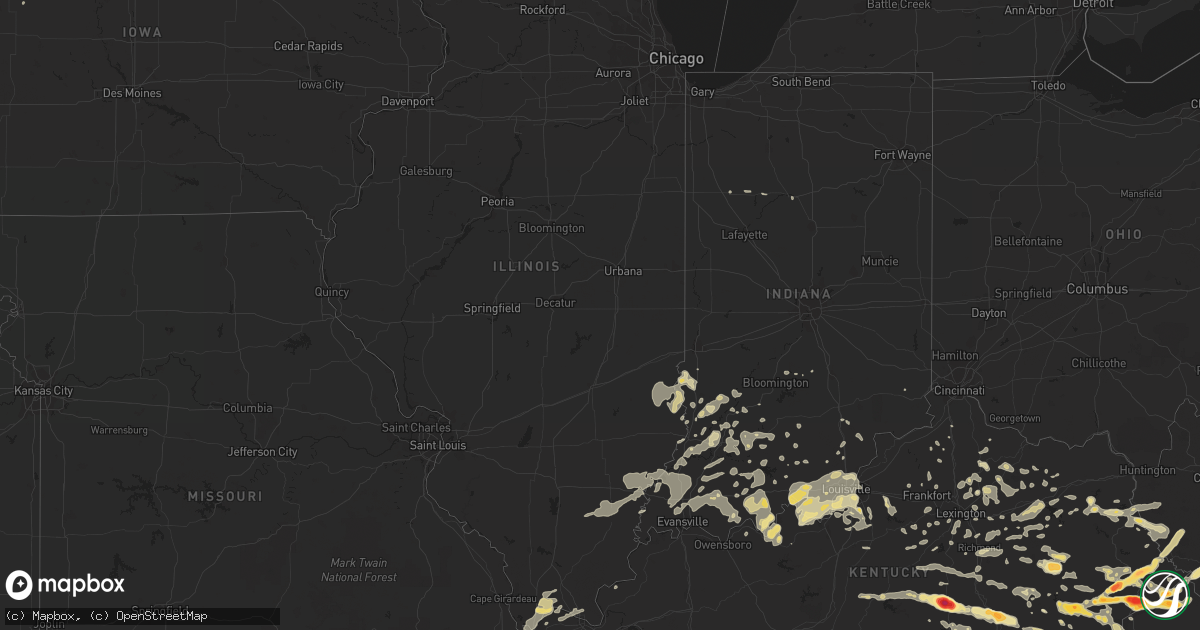
Hail Map in Kentucky on April 9, 2011
Get this storm
April 9 map
$229
one time, instant access
Download today. No call, no setup
Keep the $229
Bought the map and want the full workflow? Apply the entire $229 to a subscription within 7 days. None of it is wasted.
Every map, not just this one
This buys you this map. Subscription and you get every map we run, in the markets you choose from a few cities to whole states to nationwide. Plus real-time alerts the moment a storm fires.
Contact data
Name, contact info, occupancy, even credit band for addresses in the footprint. You go from where it hit to who to call.
Become the source they trust
Unlimited branding weather history reports on demand. You already have the documented answer ready for the property owner, and you are the one who showed up with it.
Property data and RoofTrace estimates
Pull up any address you have got, its value and the exact code rules for that jurisdiction, straight from One Click Code. Then RoofTrace estimates the squares, pitch, and roof value, priced the way you price.
Storm reports in Kentucky
Kentucky
| Date | Description |
|---|---|
| 04/09/20114:30 PM CDT | Large tree across road at coon creek fire department. |
| 04/09/20114:20 PM CDT | A local report indicates 1.75 inch wind near WOOTON |
| 04/09/20112:58 PM CDT | Trees down blocking the road at dry fork of greasy. |
| 04/09/20112:58 PM CDT | *** 2 inj *** trailer blown over with people inside. |
| 04/09/20112:58 PM CDT | Trees blown down onto residence along road creek rd |
| 04/09/20112:55 PM CDT | Observed on sugar camp branch road. |
| 04/09/20112:50 PM CDT | Large tree down across 195 |
| 04/09/20112:48 PM CDT | Tree down across ratliff creek road |
| 04/09/20112:48 PM CDT | Several reports of trees down across the area. 1 tree down just past lookout school. Another at the mouth of powells cr. |
| 04/09/20112:45 PM CDT | A local report indicates 1.50 inch wind near WALLINS CREEK |
| 04/09/20112:40 PM CDT | From harlan awos. |
| 04/09/20112:30 PM CDT | Trees down...roofs blown off including a small supermarket...billboards down...power lines down and numerous windows blown out of downtown businesses. |
| 04/09/20112:25 PM CDT | Trees down on powerlines along stinking creek road. |
| 04/09/20112:22 PM CDT | Trees down on coon creek. |
| 04/09/20112:20 PM CDT | A local report indicates 1.75 inch wind near LONDON |
| 04/09/20112:20 PM CDT | Trees down near the intersection of highway 550 and fourmile hollow road |
| 04/09/20112:16 PM CDT | Trees down on second fork. |
| 04/09/20112:12 PM CDT | Trees down on dryhill road. |
| 04/09/20112:10 PM CDT | Magoffin county em reports a trailer was blown over off of rt 3334 near hwy 1081. |
| 04/09/20112:07 PM CDT | A local report indicates 1.75 inch wind near CORBIN |
| 04/09/20112:00 PM CDT | Magoffin em reports a trailer was blown over off of rt 3334 near 1081 |
| 04/09/20112:00 PM CDT | A local report indicates 1.00 inch wind near CORBIN |
| 04/09/20111:53 PM CDT | A local report indicates 1.75 inch wind near 2 W JACKSON |
| 04/09/20111:50 PM CDT | A local report indicates 1.00 inch wind near BUSH |
| 04/09/20111:47 PM CDT | Part of a roof was stripped from a home in island city. Also reported pea sized hail. |
| 04/09/20111:47 PM CDT | Part of a roof was stripped from a home in island city. Also reported pea sized hail. |
| 04/09/20111:43 PM CDT | A local report indicates 1.75 inch wind near LONDON |
| 04/09/20111:37 PM CDT | Trees down and debris in roadway were reported on ky1081 between mile markers 8 and 9. |
| 04/09/20111:34 PM CDT | A local report indicates 1.75 inch wind near LONDON |
| 04/09/20111:31 PM CDT | Trees down and debris in the roadway were reported on ky 2019 between mile markers 1 and 5. |
| 04/09/20111:30 PM CDT | A local report indicates 1.00 inch wind near WILLIAMSON |
| 04/09/20111:30 PM CDT | Roof damage to a home on jackson county high school road. |
| 04/09/20111:27 PM CDT | Trees and debris in the roadway were reported on ky 2022 between mile markers 0 and 2. |
| 04/09/20111:20 PM CDT | A local report indicates 1.00 inch wind near 4 S SOMERSET |
| 04/09/20111:20 PM CDT | Numerous trees blown down across 844. Largest was a willow tree approx 20 inches in diameter. |
| 04/09/20111:17 PM CDT | A local report indicates 4.00 inch wind near 1 S EUBANK |
| 04/09/20111:15 PM CDT | Trees down in oak grove community. |
| 04/09/20111:13 PM CDT | A local report indicates 1.75 inch wind near EUBANK |
| 04/09/20111:12 PM CDT | A local report indicates 1.75 inch wind near META |
| 04/09/20111:10 PM CDT | Structure damage to mobile homes...barn and house on chapels branch. |
| 04/09/20111:08 PM CDT | Most hail the size of pennies and nickels. |
| 04/09/20111:08 PM CDT | Car windows and home windows broken. |
| 04/09/20111:05 PM CDT | A local report indicates 1.00 inch wind near 2 ESE PHELPS |
| 04/09/20111:05 PM CDT | Storm survey confirmed an ef0 tornado that touched down near county road 2027. Estimated max winds 80 to 85 mph. |
| 04/09/20111:04 PM CDT | Roof blown off of a house on hizer hill road |
| 04/09/20111:03 PM CDT | A local report indicates 1.00 inch wind near BEREA |
| 04/09/20111:00 PM CDT | Storm survey confirmed an ef0 tornado that touched down near highway 715 in the daniel boone national forest. The tornado crossed highway 715 and entered wolfe county. |
| 04/09/20111:00 PM CDT | Several vehicles damaged by hail at the state police post. |
| 04/09/20111:00 PM CDT | Multiple trees uprooted on corner ridge road |
| 04/09/20111:00 PM CDT | A local report indicates 2.75 inch wind near EUBANK |
| 04/09/201112:56 PM CDT | A local report indicates 1.75 inch wind near PIKEVILLE |
| 04/09/201112:52 PM CDT | A local report indicates 2.75 inch wind near VIRGIE |
| 04/09/201112:52 PM CDT | Several large tree branches blocking east bound left lane of the mountain parkway near mile marker 28 |
| 04/09/201112:50 PM CDT | Trees down. |
| 04/09/201112:50 PM CDT | Power lines down. |
| 04/09/201112:50 PM CDT | Power lines down. |
| 04/09/201112:48 PM CDT | Utility poles snapped off near the middle school. |
| 04/09/201112:47 PM CDT | Tress down just south of the city along with power lines. |
| 04/09/201112:45 PM CDT | A local report indicates 1.00 inch wind near 8 S LOUISA |
| 04/09/201112:42 PM CDT | A local report indicates 1.00 inch wind near LIBERTY |
| 04/09/201112:40 PM CDT | Some power lines down. |
| 04/09/201112:35 PM CDT | A local report indicates 2.75 inch wind near KITE |
| 04/09/201112:30 PM CDT | A local report indicates 1.75 inch wind near LITTCARR |
| 04/09/201112:20 PM CDT | Trees reported down. |
| 04/09/201112:15 PM CDT | A local report indicates 1.00 inch wind near 4 W CAMPBELLSVILLE |
| 04/09/201112:08 PM CDT | Tree limbs and poles down. |
| 04/09/201112:00 PM CDT | A local report indicates 1.00 inch wind near SALT LICK |
| 04/09/201111:49 AM CDT | Trees down. |
| 04/09/201111:47 AM CDT | Shop building roof blown off also tree top blown down. |
| 04/09/201111:14 AM CDT | A local report indicates 1.00 inch wind near SALT LICK |
| 04/09/201110:56 AM CDT | A local report indicates 1.00 inch wind near LAWRENCEBURG |
| 04/09/201110:52 AM CDT | Unconfirmed tornado damage. Several trees down and structures damaged. Many roads blocked by trees. |
| 04/09/201110:46 AM CDT | Numerous trees reported down across county. |
| 04/09/201110:43 AM CDT | Tree and power lines dow in sulphur. |
| 04/09/201110:41 AM CDT | Some trees down across the county. |
| 04/09/201110:40 AM CDT | Trees and power lines down. |
| 04/09/201110:40 AM CDT | Trees reported down just north of the city. |
| 04/09/201110:38 AM CDT | Tree reported down on a house. |
| 04/09/201110:27 AM CDT | A local report indicates 1.00 inch wind near JEFFERSONTOWN |
| 04/09/201110:24 AM CDT | Numerous power lines down across the city. |
| 04/09/201110:22 AM CDT | Building damage at blankenbaker and electron drive |
| 04/09/201110:19 AM CDT | Tress down along dixie highway. |
| 04/09/201110:17 AM CDT | Large tree blocking rollington rd as well as power lines down |
| 04/09/201110:15 AM CDT | Large pole down hikes point. |
| 04/09/201110:12 AM CDT | A local report indicates 1.00 inch wind near 2 N OKOLONA |
| 04/09/201110:07 AM CDT | Hail fell between 1107 and 1122 am |
| 04/09/20118:41 AM CDT | A local report indicates 1.00 inch wind near 2 SE MOUTHCARD |
All States Impacted by Hail Map on April 9, 2011
Cities Impacted by Hail Map on April 9, 2011
- Bancroft, IA
- Mabel, MN
- Walnut Grove, MN
- Hindman, KY
- Littcarr, KY
- Mallie, KY
- Pittsville, WI
- Vesper, WI
- Newland, NC
- Battle Creek, NE
- Norfolk, NE
- Whitesburg, KY
- Cornettsville, KY
- Premium, KY
- Letcher, KY
- Blackey, KY
- Roxana, KY
- Hallie, KY
- Surgoinsville, TN
- Church Hill, TN
- Gate City, VA
- Rogersville, TN
- Thorn Hill, TN
- Mooresburg, TN
- Le Mars, IA
- Merrill, IA
- Chrisney, IN
- Grandview, IN
- Richland Center, WI
- Rodney, MI
- Barryton, MI
- Mecosta, MI
- Jonesville, KY
- Dry Ridge, KY
- Laconia, IN
- Elizabeth, IN
- Saint Ansgar, IA
- Leland, IA
- Glenville, MN
- Ventura, IA
- Austin, MN
- Titonka, IA
- Stacyville, IA
- Hayward, MN
- Garner, IA
- Woden, IA
- Kensett, IA
- Thompson, IA
- Fenton, IA
- Osage, IA
- Clear Lake, IA
- Mason City, IA
- Lake Mills, IA
- Hanlontown, IA
- Lyle, MN
- Burt, IA
- Plymouth, IA
- Carpenter, IA
- Joice, IA
- Grafton, IA
- Forest City, IA
- Algona, IA
- Whittemore, IA
- Manly, IA
- Albert Lea, MN
- Lone Rock, IA
- Northwood, IA
- Buffalo Center, IA
- Fertile, IA
- Emmons, MN
- Jasper, IN
- Richmond, KY
- Winchester, KY
- Waco, KY
- Eastover, SC
- Turner, MI
- Au Gres, MI
- Tawas City, MI
- Russell, MN
- Balaton, MN
- Harrison, MI
- Mount Olivet, KY
- Carlisle, KY
- Ewing, KY
- Flag Pond, TN
- Shelburn, IN
- Farmersburg, IN
- Fairbanks, IN
- Sullivan, IN
- Holstein, IA
- Lawrenceville, IL
- Bridgeport, IL
- Tracy, MN
- New Market, TN
- Lugoff, SC
- Andrews, SC
- Paris, KY
- Dahlgren, IL
- Macedonia, IL
- Belle Rive, IL
- Flat Rock, IL
- Mount Airy, NC
- Gaffney, SC
- Lebanon Junction, KY
- Lake Wilson, MN
- Manton, MI
- Harrietta, MI
- Irons, MI
- Falmouth, MI
- Wellston, MI
- Luther, MI
- Cadillac, MI
- Boon, MI
- Lake City, MI
- McBain, MI
- Tustin, MI
- Dante, SD
- Wagner, SD
- Avon, SD
- Buckhorn, KY
- Oneida, KY
- Wesley, IA
- Burnsville, NC
- Mars Hill, NC
- Loris, SC
- Hickory, NC
- Ages Brookside, KY
- Evarts, KY
- Saint Charles, VA
- Pennington Gap, VA
- Cranks, KY
- Kenvir, KY
- Baxter, KY
- Cawood, KY
- Boone, NC
- Deep Gap, NC
- Todd, NC
- Millers Creek, NC
- Fleetwood, NC
- West Jefferson, NC
- Purlear, NC
- Emmetsburg, IA
- Cylinder, IA
- Sargeant, MN
- Pine River, WI
- Weyauwega, WI
- Waupaca, WI
- Kings Mountain, KY
- Waynesburg, KY
- Yosemite, KY
- Eubank, KY
- Bethelridge, KY
- Science Hill, KY
- Somerset, KY
- Harpers Ferry, IA
- Lewis, KS
- Larned, KS
- Hudson, KS
- Belpre, KS
- St John, KS
- Haviland, KS
- Macksville, KS
- Catron, MO
- Greenup, IL
- Hart, MI
- Rutherfordton, NC
- Mitchell, IN
- Shoals, IN
- Negaunee, MI
- Ishpeming, MI
- Gwinn, MI
- Fort Mill, SC
- Mooresboro, NC
- Ellenboro, NC
- Shelby, NC
- Forest City, NC
- Kite, KY
- Pine Top, KY
- Rushford, MN
- Genoa, WV
- Tyner, KY
- Booneville, KY
- Sextons Creek, KY
- West Bend, IA
- Albion, IL
- Canton, NC
- Fairfield, IL
- New Hampton, IA
- Vincennes, IN
- Rose Hill, VA
- Owingsville, KY
- Hillsboro, KY
- Georgetown, SC
- Cleveland, VA
- Honaker, VA
- Lebanon, VA
- Ridgeway, SC
- Camden, SC
- Wallace, SC
- Bishopville, SC
- Schuyler, NE
- Trade, TN
- Mountain City, TN
- Zionville, NC
- Marshall, NC
- Tyler, MN
- Golden Gate, IL
- Palmer, IA
- Chapmanville, WV
- Holden, WV
- Dingess, WV
- Delbarton, WV
- Mesick, MI
- Blacksburg, SC
- Three Lakes, WI
- Schaller, IA
- Pelzer, SC
- Spruce Pine, NC
- Sumter, SC
- Wedgefield, SC
- Dalzell, SC
- Shaw Afb, SC
- Beaverton, MI
- Gladwin, MI
- Marion, NC
- Bakersville, NC
- Flandreau, SD
- Ruthton, MN
- Elkton, SD
- Pipestone, MN
- Glade Spring, VA
- Land O'Lakes, WI
- Afton, TN
- Bulls Gap, TN
- Whitesburg, TN
- Telford, TN
- Limestone, TN
- Sneedville, TN
- Tazewell, TN
- Eidson, TN
- Jonesborough, TN
- Chuckey, TN
- Greeneville, TN
- Mosheim, TN
- Lancaster, SC
- Catawba, SC
- Saint Stephen, SC
- Pineville, SC
- Bonneau, SC
- Rembrandt, IA
- Sioux Rapids, IA
- Linn Grove, IA
- Amboy, MN
- Vernon Center, MN
- Garden City, MN
- Liberty, KY
- London, KY
- Seymour, WI
- Sharon, SC
- Hickory Grove, SC
- Manchester, KY
- Warbranch, KY
- Beverly, KY
- Helton, KY
- Hubbard, NE
- Homer, NE
- Kimper, KY
- Bevinsville, KY
- Belfry, KY
- Wayland, KY
- McDowell, KY
- Teaberry, KY
- Topmost, KY
- Canada, KY
- Pippa Passes, KY
- Raccoon, KY
- Raven, KY
- Grethel, KY
- Beaver, KY
- Sidney, KY
- Pikeville, KY
- Hi Hat, KY
- Dema, KY
- Harold, KY
- Whiting, IA
- Hornick, IA
- Smithland, IA
- Bode, IA
- Ottosen, IA
- Jefferson, SD
- Ponca, NE
- Watersmeet, MI
- Hazard, KY
- Viper, KY
- Vicco, KY
- Jeff, KY
- Busy, KY
- Hyden, KY
- Wooton, KY
- Green Bay, WI
- Pulaski, WI
- Salem, SD
- Riceville, IA
- Lime Springs, IA
- Elma, IA
- Mallard, IA
- Rolfe, IA
- Nashville, IN
- Hartsville, SC
- Clay City, KY
- Rising City, NE
- David City, NE
- Bluefield, VA
- Westfield, IA
- Akron, IA
- Plainville, IN
- Washington, IN
- Worthington, MN
- Garfield, KY
- Howells, NE
- Clarkson, NE
- Rock Hill, SC
- Meadowview, VA
- Bellwood, NE
- Shelby, NE
- Manistee, MI
- Gillett Grove, IA
- Dickens, IA
- Webb, IA
- Greenville, IA
- Heath Springs, SC
- Strawberry Plains, TN
- Knoxville, TN
- Sevierville, TN
- Kodak, TN
- Storm Lake, IA
- Alta, IA
- Montrose, SD
- Cynthiana, KY
- Sloan, IA
- Salix, IA
- Colman, SD
- Stephensport, KY
- Correctionville, IA
- Pierson, IA
- Wayne, NE
- Wakefield, NE
- Madison Lake, MN
- Jasper, MN
- Loogootee, IN
- Manning, SC
- Phelps, WI
- Marshall, MN
- Chilhowie, VA
- Abingdon, VA
- Saltville, VA
- Emerson, NE
- Isonville, KY
- Sandy Hook, KY
- Fries, VA
- Derby, IN
- Cannelton, IN
- Rome, IN
- Walthill, NE
- Newman Grove, NE
- Madison, NE
- Lindsay, NE
- Saint Edward, NE
- Albion, NE
- Darlington, SC
- Florence, SC
- Corydon, IN
- Virgie, KY
- Ashcamp, KY
- Shelby Gap, KY
- Jenkins, KY
- Hellier, KY
- Elkhorn City, KY
- Waterville, MN
- Belmont, NC
- Clover, SC
- Gastonia, NC
- Lynchburg, SC
- Olanta, SC
- Timmonsville, SC
- Lamar, SC
- South Williamson, KY
- Lenore, WV
- Williamson, WV
- Sassafras, KY
- Bentley, MI
- Sterling, MI
- Kilkenny, MN
- Montgomery, MN
- Conover, WI
- Varney, KY
- Prestonsburg, KY
- Hueysville, KY
- Garner, KY
- Forest Hills, KY
- Gunlock, KY
- Lackey, KY
- Garrett, KY
- Eastern, KY
- Mousie, KY
- Langley, KY
- Marcus, IA
- Kingsley, IA
- Washta, IA
- Elk Point, SD
- Cushing, IA
- Anthon, IA
- Danbury, IA
- Battle Creek, IA
- Jackson, KY
- Casar, NC
- Lawndale, NC
- Sandborn, IN
- Carlisle, IN
- Cyclone, WV
- Clear Fork, WV
- Coal Mountain, WV
- Oceana, WV
- White Pine, TN
- Morristown, TN
- Newport, TN
- Waxhaw, NC
- Charlotte, NC
- Cherokee, IA
- Quimby, IA
- Aurelia, IA
- Cherryville, NC
- Dell Rapids, SD
- Garretson, SD
- Baltic, SD
- Colton, SD
- Rembert, SC
- Liberty Hill, SC
- Rhodes, MI
- Alger, MI
- Grundy, VA
- Big Rock, VA
- Mouthcard, KY
- Lick Creek, KY
- Steele, KY
- Marion, MI
- Lanesville, IN
- Mayesville, SC
- Louisa, KY
- Pocahontas, IA
- Havelock, IA
- Laurens, IA
- Albert City, IA
- Meriden, IA
- Peterson, IA
- Cleghorn, IA
- Cairo, IL
- Mounds, IL
- Mound City, IL
- Carmi, IL
- Enfield, IL
- Breeden, WV
- Kermit, WV
- New Franken, WI
- Luxemburg, WI
- Del Rio, TN
- Early, IA
- Nemaha, IA
- Valdese, NC
- Morganton, NC
- Bridgewater, SD
- Emery, SD
- Canistota, SD
- Lu Verne, IA
- Hemingway, SC
- Johnsonville, SC
- Cresco, IA
- Ridgeway, IA
- Galva, IA
- Floyds Knobs, IN
- New Albany, IN
- Sellersburg, IN
- Madison, SD
- Chester, SD
- Spencer, SD
- Wayne City, IL
- Hardinsburg, KY
- Heidrick, KY
- Flat Lick, KY
- Walker, KY
- Corbin, KY
- Girdler, KY
- Barbourville, KY
- Bimble, KY
- Hinkle, KY
- Cannon, KY
- Gray, KY
- Keavy, KY
- Nebo, NC
- Old Fort, NC
- Roan Mountain, TN
- Trent, SD
- Mauckport, IN
- Louisville, KY
- Brandenburg, KY
- New Richland, MN
- Waseca, MN
- Lake Crystal, MN
- Clinton, TN
- Briceville, TN
- Rocky Top, TN
- Lanesboro, MN
- York, SC
- Park Falls, WI
- Prospect, KY
- Clarksville, IN
- Jeffersonville, IN
- Georgetown, IN
- Borden, IN
- Memphis, IN
- Charlestown, IN
- Ullin, IL
- Olmsted, IL
- Grand Chain, IL
- Alexandria, SD
- Parkston, SD
- Ethan, SD
- Dale, IN
- Huntingburg, IN
- Great Falls, SC
- Fort Lawn, SC
- Britt, IA
- Mount Carmel, IL
- Candler, NC
- Thompsonville, MI
- Lakota, IA
- Golconda, IL
- Ferguson, KY
- Moores Hill, IN
- Unionville, IN
- Bloomington, IN
- Morgan, MN
- Clements, MN
- Redwood Falls, MN
- Claudville, VA
- Huntsville, TN
- Cedar Bluff, VA
- Long Lake, WI
- Johnson City, TN
- Kingsport, TN
- Fall Branch, TN
- New Lisbon, WI
- Shepherdsville, KY
- Faribault, MN
- Kingstree, SC
- Waterbury, NE
- Salvisa, KY
- Versailles, KY
- Mapleton, IA
- Lake City, IA
- Pound, VA
- Marion, VA
- Ararat, VA
- Butternut, WI
- Fairfax, MN
- Sleepy Eye, MN
- West Liberty, KY
- Wellington, KY
- Morehead, KY
- Frankfort, KY
- Owenton, KY
- Brillion, WI
- Pineville, NC
- Boyceville, WI
- Boyd, MN
- Clarkfield, MN
- Bancroft, NE
- Rosalie, NE
- Tomah, WI
- Kings Mountain, NC
- Dallas, NC
- Bessemer City, NC
- Saint Croix, IN
- Hawesville, KY
- Saint Meinrad, IN
- Branchville, IN
- Cloverport, KY
- Ferdinand, IN
- Evanston, IN
- Birdseye, IN
- Lamar, IN
- Tell City, IN
- Troy, IN
- Leopold, IN
- Bristow, IN
- Santa Claus, IN
- Taylorsville, KY
- Mount Washington, KY
- Annapolis, IL
- Robinson, IL
- Stoy, IL
- Hutsonville, IL
- Hayesville, NC
- Rabun Gap, GA
- Blackwater, VA
- Duffield, VA
- Flora, IL
- Hustonville, KY
- Stanford, KY
- Vancleve, KY
- Beattyville, KY
- Campton, KY
- Troutdale, VA
- Sugar Grove, VA
- Elk Creek, VA
- Bostic, NC
- Pierce, NE
- Tennyson, IN
- Greensburg, KS
- Pekin, IN
- Pender, NE
- Omer, MI
- West Branch, MI
- Standish, MI
- Twining, MI
- Finchville, KY
- Shelbyville, KY
- Cherokee, NC
- Cosby, TN
- Tripp, SD
- Delmont, SD
- Ekron, KY
- Payneville, KY
- Ramsey, IN
- Battletown, KY
- Fairdale, KY
- Brooks, KY
- Guston, KY
- New Middletown, IN
- Depauw, IN
- Central, IN
- Leavenworth, IN
- Lucan, MN
- Lamberton, MN
- Wabasso, MN
- Jefferson, SC
- Kershaw, SC
- Paoli, IN
- La Crescent, MN
- Houston, MN
- Yolyn, WV
- Burnt Prairie, IL
- Mill Shoals, IL
- Lynd, MN
- Henryville, IN
- Sims, IL
- Geff, IL
- Eagle River, WI
- Moville, IA
- Piedmont, SC
- Castlewood, VA
- Racine, MN
- Fort Gay, WV
- Crum, WV
- Wilsondale, WV
- Inez, KY
- East Lynn, WV
- Egan, SD
- Seneca, SC
- West Union, SC
- McBee, SC
- Pilgrim, KY
- Janesville, MN
- Clay City, IL
- Mount Erie, IL
- West Salem, IL
- Celestine, IN
- Dubois, IN
- Schnellville, IN
- Climbing Hill, IA
- Plover, IA
- Castana, IA
- Arthur, IA
- Newell, IA
- Hinton, IA
- Larrabee, IA
- Odebolt, IA
- Fonda, IA
- Rodney, IA
- Remsen, IA
- Oto, IA
- Varina, IA
- Sac City, IA
- Lawton, IA
- Curlew, IA
- Truesdale, IA
- Ida Grove, IA
- Houghton Lake, MI
- Milan, MN
- Appleton, MN
- Madison, MN
- East Bernstadt, KY
- Mount Vernon, KY
- North Spring, WV
- Panther, WV
- Hanover, WV
- Baisden, WV
- Mohawk, WV
- Gilbert, WV
- Wharncliffe, WV
- Holland, MN
- Woodstock, MN
- Partridge, KY
- Eolia, KY
- Bybee, TN
- Jeffersonville, KY
- Cramerton, NC
- Evart, MI
- Burnside, KY
- Winside, NE
- Hoskins, NE
- Heiskell, TN
- Scandinavia, WI
- Coloma, WI
- Westfield, WI
- Oyens, IA
- Orlando, KY
- McKee, KY
- McLeansboro, IL
- Norris City, IL
- Bicknell, IN
- Ragsdale, IN
- New Liberty, KY
- Jefferson City, TN
- Dandridge, TN
- Ricetown, KY
- Keenes, IL
- Richburg, SC
- Blackstock, SC
- Winnsboro, SC
- Orleans, IN
- Campbellsburg, IN
- Connelly Springs, NC
- Galax, VA
- Sioux City, IA
- Allen, NE
- Stanton, NE
- South Sioux City, NE
- Meadow Grove, NE
- Wisner, NE
- North Sioux City, SD
- Carroll, NE
- Jackson, NE
- Concord, NE
- Thurston, NE
- Winnebago, NE
- Dakota City, NE
- Liberty, SC
- Easley, SC
- Alexander, NC
- Patrick, SC
- Society Hill, SC
- Irvine, KY
- Clintonville, WI
- Bear Creek, WI
- Black Creek, WI
- Shiocton, WI
- Pamplico, SC
- Effingham, SC
- Coward, SC
- Warrens, WI
- Bethune, SC
- Presho, SD
- Lake, MI
- Clare, MI
- Cassatt, SC
- Lincolnton, NC
- Cheraw, SC
- Kevil, KY
- Harts, WV
- Kinsley, KS
- Owensville, IN
- Fort Branch, IN
- Hortonville, WI
- New London, WI
- Brewster, MN
- Mount Croghan, SC
- Pageland, SC
- Monroe, NC
- Drexel, NC
- Willow Hill, IL
- Oblong, IL
- Grand Meadow, MN
- Dexter, MN
- Denmark, WI
- Barnardsville, NC
- Wallingford, KY
- Mapleton, MN
- Saint James, MN
- Dawson, MN
- Nashua, IA
- Ionia, IA
- West York, IL
- Campbellsville, KY
- Pemberton, MN
- Bandy, VA
- Pounding Mill, VA
- Tazewell, VA
- North Tazewell, VA
- Rinard, IL
- Cisne, IL
- Johnsonville, IL
- Renville, MN
- Wickliffe, KY
- Mantorville, MN
- Kasson, MN
- Mount Vernon, IL
- Scranton, SC
- Rockford, IA
- Le Roy, MN
- Dakota, MN
- Grover, NC
- La Center, KY
- Villa Ridge, IL
- Karnak, IL
- Cypress, IL
- Hartington, NE
- Windom, MN
- Amherstdale, WV
- French Lick, IN
- Rutledge, TN
- Sparta, WI
- Swaledale, IA
- Mills River, NC
- Horse Shoe, NC
- Phelps, KY
- Wells, MN
- Slayton, MN
- Garvin, MN
- Holcombe, WI
- Bancroft, WI
- Onawa, IA
- Decatur, NE
- Madelia, MN
- Truman, MN
- Winnebago, MN
- Good Thunder, MN
- Orchard, IA
- Charles City, IA
- Barnum, IA
- Fort Dodge, IA
- Saint Helen, MI
- Bitely, MI
- Rose Creek, MN
- Jonesville, VA
- Kyles Ford, TN
- Mozelle, KY
- Stinnett, KY
- Paris Crossing, IN
- Deputy, IN
- Austin, IN
- Mendota, VA
- Bristol, VA
- Chavies, KY
- Lost Creek, KY
- Whick, KY
- Lawler, IA
- Salt Lick, KY
- Olympia, KY
- Weeksbury, KY
- Haysi, VA
- Vansant, VA
- Oakwood, VA
- Clintwood, VA
- Kingsley, MI
- Fife Lake, MI
- Woodlawn, VA
- Parrottsville, TN
- Barnhill, IL
- Gresham, SC
- Brethren, MI
- Olive Hill, KY
- Hampton, TN
- Pathfork, KY
- Kettle Island, KY
- Stoney Fork, KY
- Miracle, KY
- Pineville, KY
- Wallins Creek, KY
- Arjay, KY
- Coldiron, KY
- Harlan, KY
- Hulen, KY
- Ewing, VA
- Wentworth, SD
- Chester, SC
- Nora Springs, IA
- Rudd, IA
- Suamico, WI
- Lewisport, KY
- Holmen, WI
- Barlow, KY
- Marion, IL
- Pittsburg, IL
- Thompsonville, IL
- Alcolu, SC
- Corwith, IA
- Kanawha, IA
- Renwick, IA
- Livermore, IA
- Greensburg, KY
- Dunlow, WV
- Preston, MN
- Unicoi, TN
- Green Mountain, NC
- Powell, TN
- Andersonville, TN
- Rogers, NE
- Linwood, NE
- Palestine, IL
- Merom, IN
- Bear Lake, MI
- Arcadia, MI
- Peterson, MN
- Elk Park, NC
- Lexington, KY
- Lyons, IN
- Linton, IN
- Switz City, IN
- Hudson, NC
- Lenoir, NC
- Granite Falls, NC
- Buncombe, IL
- Randolph, NE
- Ayrshire, IA
- Ruthven, IA
- Caledonia, MN
- Combs, KY
- Drift, KY
- Martin, KY
- Redfox, KY
- Banner, KY
- Robinson Creek, KY
- Shelbiana, KY
- Thousandsticks, KY
- Printer, KY
- Stanville, KY
- Dana, KY
- Betsy Layne, KY
- Carrie, KY
- Isom, KY
- Deane, KY
- Norton, VA
- David, KY
- Scuddy, KY
- Leburn, KY
- Appalachia, VA
- Wise, VA
- Jeremiah, KY
- Tram, KY
- Ivel, KY
- Minnie, KY
- Logan, WV
- Happy, KY
- Rural Retreat, VA
- Crockett, VA
- Marion, KY
- Adrian, MN
- Matthews, NC
- Union Mills, NC
- Moncks Corner, SC
- Wisconsin Rapids, WI
- Bloomfield, IN
- Newberry, IN
- Twin Lakes, MN
- Lake City, SC
- Gilmore City, IA
- Lansing, NC
- Edgerton, MN
- Brooksville, KY
- Berry, KY
- Falmouth, KY
- Ranger, WV
- Kaleva, MI
- Onekama, MI
- Buckley, MI
- Beulah, MI
- Benzonia, MI
- Frankfort, MI
- Copemish, MI
- Grawn, MI
- Interlochen, MI
- Mankato, MN
- Erwin, TN
- Lyons, KS
- Lynnville, IN
- Boonville, IN
- Broughton, IL
- Bledsoe, KY
- Laurel Bloomery, TN
- Damascus, VA
- Rudolph, WI
- Loyall, KY
- Bertrand, MO
- East Prairie, MO
- Nicholasville, KY
- Branch, MI
- New Ulm, MN
- Blue Earth, MN
- Chandler, MN
- Centerville, SD
- Peachland, NC
- Franklin, MN
- Sumner, IL
- Winona, MN
- Owatonna, MN
- Traverse City, MI
- South Boardman, MI
- Nineveh, IN
- Minocqua, WI
- Davin, WV
- Hayfield, MN
- Grayville, IL
- Browns, IL
- English, IN
- Weaverville, NC
- Stromsburg, NE
- Hardinsburg, IN
- Blaine, KY
- Adams, KY
- Decorah, IA
- Casey, IL
- Shelby, MI
- Big Laurel, KY
- Boston, KY
- Bardstown, KY
- New Haven, KY
- Coleridge, NE
- Danbury, WI
- Elk Horn, KY
- Columbia, KY
- Summersville, KY
- Walhalla, SC
- Central, SC
- Salem, SC
- Six Mile, SC
- Norris, SC
- Regina, KY
- Hurley, VA
- Breaks, VA
- Belcher, KY
- Thornfield, MO
- Theodosia, MO
- Laurens, SC
- Gibbon, MN
- Iuka, IL
- Alta Vista, IA
- Colwell, IA
- Floyd, IA
- Scalf, KY
- Nancy, KY
- Lewisville, MN
- Manawa, WI
- Gable, SC
- Huger, SC
- Cordesville, SC
- New Zion, SC
- Marshville, NC
- Wingate, NC
- Collettsville, NC
- Amherst, WI
- Webbville, KY
- Martha, KY
- Sadieville, KY
- Georgetown, KY
- Saint Francisville, IL
- Bulan, KY
- Maribel, WI
- Mishicot, WI
- Lawrenceburg, KY
- West Concord, MN
- Claremont, MN
- Spindale, NC
- Edgemoor, SC
- Smyrna, SC
- Lake Lure, NC
- West Union, IL
- Martinsville, IL
- Marshall, IL
- Cades, SC
- Nesmith, SC
- Caryville, TN
- Laurel Springs, NC
- Bean Station, TN
- Dodgeville, WI
- Columbus, NE
- Goodell, IA
- Thornton, IA
- Klemme, IA
- Meservey, IA
- Fountain, MN
- Patoka, IN
- Hazleton, IN
- Decker, IN
- Fremont, WI
- McGrady, NC
- Hays, NC
- Two Rivers, WI
- Reynolds, IN
- Monticello, IN
- New Harmony, IN
- Eckerty, IN
- Saint Anthony, IN
- Oaktown, IN
- Clayhole, KY
- Black Mountain, NC
- Underwood, IN
- Scottsburg, IN
- Waukon, IA
- Cannelburg, IN
- Montgomery, IN
- Hot Springs, NC
- Rapid River, MI
- Echo, MN
- Matthews, MO
- New Madrid, MO
- Hardwick, MN
- Blue River, WI
- Bear Branch, KY
- Clearfield, KY
- Thurmond, NC
- Wynot, NE
- Little Cedar, IA
- Sherrill, IA
- Dalton, WI
- Sharpsburg, KY
- Flemingsburg, KY
- Crothersville, IN
- Vincent, KY
- Hope, KY
- Mount Sterling, KY
- Means, KY
- Frenchburg, KY
- Lac Du Flambeau, WI
- Turbeville, SC
- Sheffield, IA
- Rockwell, IA
- Greeleyville, SC
- Elliott, SC
- Salters, SC
- Utica, MN
- Lewiston, MN
- Monticello, KY
- Bronston, KY
- Helenwood, TN
- Robbins, TN
- Odon, IN
- Pimento, IN
- Leroy, MI
- Keokee, VA
- Dayhoit, KY
- Grays Knob, KY
- Gulston, KY
- Mary Alice, KY
- Coalgood, KY
- Chaplin, KY
- Willisburg, KY
- Worthington, IN
- Lexington, IN
- Crittenden, KY
- Lake Benton, MN
- Sergeant Bluff, IA
- Lake View, IA
- Graettinger, IA
- Adams, MN
- Bronson, IA
- Marathon, IA
- Spencer, IA
- Wall Lake, IA
- Charter Oak, IA
- Scarville, IA
- Mount Carmel, TN
- Oakland, NE
- Westville, SC
- Blenheim, SC
- Latta, SC
- Armstrong, IA
- Edwardsport, IN
- Idaville, IN
- Burnettsville, IN
- Stendal, IN
- Evansville, IN
- Rockport, IN
- Chandler, IN
- Gentryville, IN
- Oakland City, IN
- Elberfeld, IN
- Parkers Lake, KY
- Dryden, VA
- Monroe City, IN
- Wheatland, IN
- Free Soil, MI
- Denniston, KY
- Toledo, IL
- Leigh, NE
- Melvin, IA
- Sheldon, WI
- Welcome, MN
- Clarion, IA
- Eagle Grove, IA
- Taswell, IN
- Macy, NE
- Casco, WI
- Milroy, MN
- Creston, NC
- Canby, MN
- Porter, MN
- Petersburg, IN
- Otwell, IN
- North Middletown, KY
- Ogdensburg, WI
- Ary, KY
- Rowdy, KY
- Emmalena, KY
- Krypton, KY
- Bonnyman, KY
- Ruby, SC
- Chesterfield, SC
- Metropolis, IL
- Bennettsville, SC
- Elgin, SC
- McAdenville, NC
- Crouse, NC
- Pinewood, SC
- McConnells, SC
- Lowell, NC
- Vale, NC
- Jamestown, SC
- Dongola, IL
- Vienna, IL
- Dunnell, MN
- Stollings, WV
- Lyburn, WV
- Mount Eden, KY
- Simpsonville, KY
- Waddy, KY
- Harmony, MN
- Canton, MN
- Clyde, NC
- Leicester, NC
- Fountain Inn, SC
- Honea Path, SC
- Simon, WV
- Blountville, TN
- Piney Flats, TN
- Craig, NE
- Tekamah, NE
- Ravenna, KY
- Stanton, KY
- Butler, TN
- Rushmore, MN
- Ivanhoe, VA
- Kewaunee, WI
- Dodge Center, MN
- Wautoma, WI
- Wild Rose, WI
- Hewett, WV
- Danville, WV
- Gays Creek, KY
- Logansport, IN
- Ludington, MI
- Cleveland, MN
- Le Center, MN
- Spring Valley, MN
- Lake Andes, SD
- Ivanhoe, MN
- Redgranite, WI
- Ferguson, NC
- Lowmansville, KY
- Kiahsville, WV
- Warfield, KY
- Lovely, KY
- Ulysses, KY
- Nichols, SC
- Xenia, IL
- Necedah, WI
- Nekoosa, WI
- Reed City, MI
- West Paducah, KY
- Elysian, MN
- Butterfield, MN
- Odin, MN
- Montevideo, MN
- Manson, IA
- Pomeroy, IA
- Bluford, IL
- Alexander, IA
- Latimer, IA
- Fancy Gap, VA
- Plover, WI
- Belview, MN
- Pentwater, MI
- Bingham Lake, MN
- West Baden Springs, IN
- Ellsworth, WI
- Charleston, MO
- Eagle Lake, MN
- Le Sueur, MN
- Fedscreek, KY
- Greenleaf, WI
- Reedsville, WI
- Springville, IN
- Sandgap, KY
- Livingston, KY
- Eastman, WI
- Ferryville, WI
- Mindoro, WI
- Onalaska, WI
- New Salisbury, IN
- Crandall, IN
- Greenville, IN
- Glenview, KY
- Coxs Creek, KY
- Milltown, IN
- Masonic Home, KY
- Clermont, KY
- West Point, KY
- Allardt, TN
- Appleton, WI
- Nickelsville, VA
- Independence, VA
- Oronoco, MN
- Pine Island, MN
- Hilbert, WI
- Freeport, MN
- Fairmont, MN
- Glade Valley, NC
- Oshkosh, WI
- Port Edwards, WI
- Iaeger, WV
- Ikes Fork, WV
- Almond, WI
- Ellery, IL
- Bruce, SD
- Lancaster, KY
- Brodhead, KY
- Danville, KY
- Crab Orchard, KY
- Berea, KY
- Junction City, KY
- Parksville, KY
- Tannersville, VA
- Thebes, IL
- Miller City, IL
- Yeaddiss, KY
- Bonduel, WI
- Stevens Point, WI
- Harrodsburg, KY
- Argonne, WI
- Hendersonville, NC
- Vermillion, SD
- Little Suamico, WI
- Albany, MN
- Cumberland, KY
- Banner Elk, NC
- Watauga, TN
- Elizabethton, TN
- Sacred Heart, MN
- Neenah, WI
- Lakefield, MN
- Okabena, MN
- Bim, WV
- Hartford, SD
- Vesta, MN
- Humboldt, SD
- Crooks, SD
- Currie, MN
- Seaforth, MN
- Walkerville, MI
- Glen Fork, WV
- Ravencliff, WV
- Boscobel, WI
- Harrogate, TN
- Marion, SC
- Slade, KY
- Wykoff, MN
- Ostrander, MN
- Winslow, IN
- Velpen, IN
- Mountain Lake, MN
- Baldwin, MI
- Poseyville, IN
- Griffin, IN
- Bellmont, IL
- Wadesville, IN
- Haubstadt, IN
- Princeton, IN
- Springerton, IL
- Cynthiana, IN
- Francisco, IN
- Crossville, IL
- Bagdad, KY
- Twilight, WV
- Newton, IL
- Bangor, WI
- Minnesota Lake, MN
- Greene, IA
- Saint Peter, MN
- Pawleys Island, SC
- Merrillan, WI
- Omaha, IL
- Eldorado, IL
- Big Creek, WV
- Hayward, WI
- Kaukauna, WI
- Saint Paul, VA
- Bedford, IN
- Williams, IN
- Medora, IN
- Alpha, MN
- Ellsworth, MN
- Mackville, KY
- Springfield, KY
- Soldiers Grove, WI
- Patrick Springs, VA
- Stuart, VA
- Shady Valley, TN
- Lennox, SD
- Wolcott, IN
- Williamstown, KY
- Neillsville, WI
- Wilson, WI
- Fredericksburg, IN
- Salem, IN
- Yale, IL


