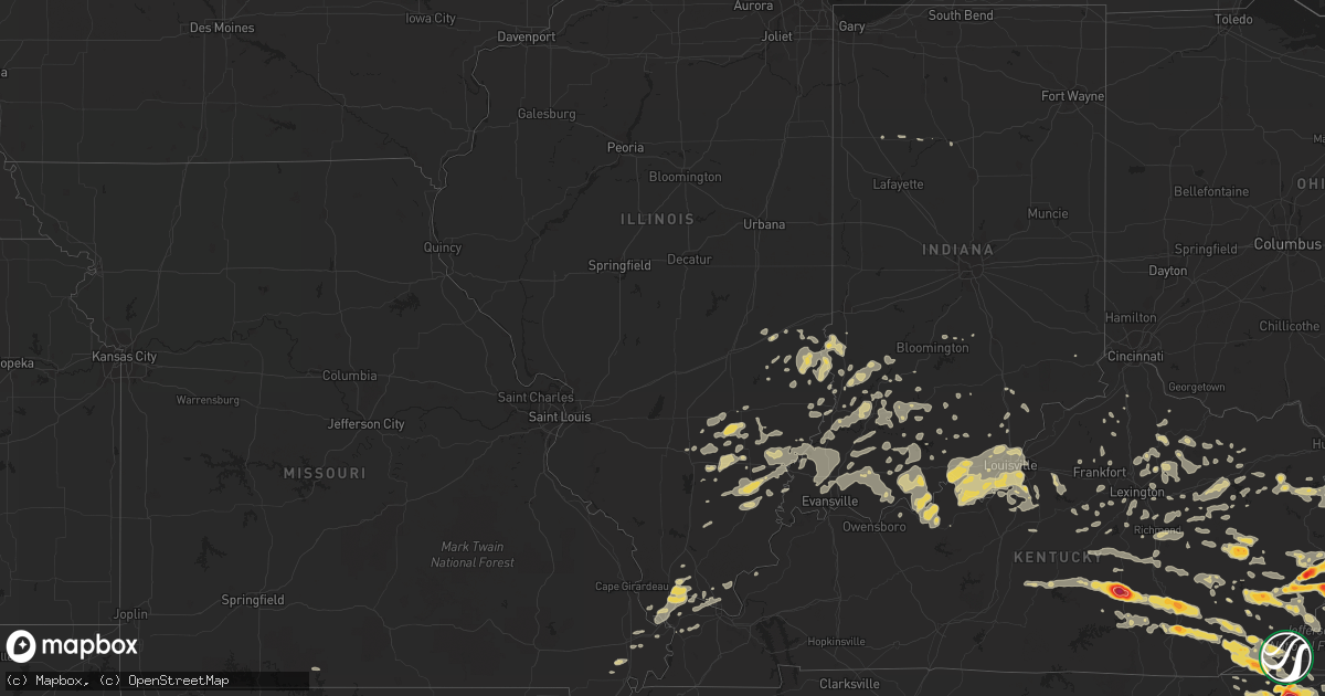
Hail Map on April 9, 2011
Get this storm
April 9 map
$229
one time, instant access
Download today. No call, no setup
Keep the $229
Bought the map and want the full workflow? Apply the entire $229 to a subscription within 7 days. None of it is wasted.
Every map, not just this one
This buys you this map. Subscription and you get every map we run, in the markets you choose from a few cities to whole states to nationwide. Plus real-time alerts the moment a storm fires.
Contact data
Name, contact info, occupancy, even credit band for addresses in the footprint. You go from where it hit to who to call.
Become the source they trust
Unlimited branding weather history reports on demand. You already have the documented answer ready for the property owner, and you are the one who showed up with it.
Property data and RoofTrace estimates
Pull up any address you have got, its value and the exact code rules for that jurisdiction, straight from One Click Code. Then RoofTrace estimates the squares, pitch, and roof value, priced the way you price.
States Impacted by Hail Map on April 9, 2011
Storm reports
Illinois
| Date | Description |
|---|---|
| 04/09/20117:35 AM CDT | A local report indicates 1.00 inch wind near HUTSONVILLE |
South Carolina
| Date | Description |
|---|---|
| 04/09/20116:55 PM CDT | Half dollar size hail |
| 04/09/20116:53 PM CDT | Quarter size hail covering the ground. |
| 04/09/20116:48 PM CDT | Local farmer reported hail damage to strawberry fields and peaches knocked off trees |
| 04/09/20116:45 PM CDT | Golf ball size hail reported at the mini mart in bethune. Windshield broke on a car. |
| 04/09/20116:40 PM CDT | Storm chaser and meteorologist reported 1.50 inch hail in the town of kershaw. |
| 04/09/20116:39 PM CDT | A local report indicates 1.00 inch wind near 6 NW HARTSVILLE |
| 04/09/20116:35 PM CDT | Half dollar size hail covering ground |
| 04/09/20116:25 PM CDT | Mcbee police department reported golf ball size hail in mcbee. |
| 04/09/20116:19 PM CDT | County emergency manager reported trees down along musket road. |
| 04/09/20116:15 PM CDT | A local report indicates 1.25 inch wind near LANCASTER |
| 04/09/20116:15 PM CDT | Spotter reports metal roof peeled off a horse stall and multiple trees down |
| 04/09/20116:10 PM CDT | County em measured golf ball sized hail with dents covering his vehicle and others. |
| 04/09/20116:07 PM CDT | Spotter reports golf ball sized hail in lancaster |
| 04/09/20116:02 PM CDT | Harmony church rd near edgemoor |
| 04/09/20116:00 PM CDT | Public reported hail up to golf ball size at the ez quick mart. |
| 04/09/20115:58 PM CDT | A local report indicates 2.00 inch wind near PLEASANT VALLEY |
| 04/09/20115:53 PM CDT | A local report indicates 1.25 inch wind near LANCASTER |
| 04/09/20115:50 PM CDT | On walnut street in rock hill. |
| 04/09/20115:35 PM CDT | Second round of hail at hw-55 and s kingsbury rd. |
| 04/09/20115:30 PM CDT | A local report indicates 1.00 inch wind near LANCASTER |
| 04/09/20115:27 PM CDT | Public reported 1.50 inch hail that covered the ground at the express mart. |
| 04/09/20115:15 PM CDT | Hail measuring 2.00 inches reported at andrew jackson state park. |
| 04/09/20115:15 PM CDT | Golf ball size hail covering the ground reported at the m and r mini mart. |
| 04/09/20115:15 PM CDT | Lancaster ema reported 3 separate episodes of hail. Golf ball sized hail occurred 615-630 pm. 1.5 to 2.0 inch hail occurred 710-720 pm. Pea to marble sized occurred 730 |
| 04/09/20115:15 PM CDT | Ham radio operator reported tennis ball size hail 1 mile south of the intersection of state route 5 and state route 75 near van wyck. |
| 04/09/20115:15 PM CDT | A local report indicates 1.75 inch wind near KINGS MOUNTAIN STATE PA |
| 04/09/20115:11 PM CDT | A local report indicates 1.00 inch wind near 4 E HICKORY TAVERN |
| 04/09/20115:09 PM CDT | Hail reported...bigger than quarter sized but smaller than golfball sized...at indian land amoco. Also...several cars with broken windshields. |
| 04/09/20115:05 PM CDT | A local report indicates 1.00 inch wind near 3 NE HICKORY TAVERN |
| 04/09/20115:00 PM CDT | A local report indicates 1.75 inch wind near CATAWBA |
| 04/09/20115:00 PM CDT | A local report indicates 1.75 inch wind near ROCK HILL |
| 04/09/20114:58 PM CDT | I-77 exit 77 |
| 04/09/20114:58 PM CDT | A local report indicates 2.00 inch wind near FORT MILL |
| 04/09/20114:52 PM CDT | A local report indicates 1.75 inch wind near TEGA CAY |
| 04/09/20114:47 PM CDT | Hw-55 and south kingsbury rd |
| 04/09/20114:42 PM CDT | A local report indicates 1.00 inch wind near PELZER |
| 04/09/20114:33 PM CDT | A local report indicates 2.00 inch wind near CLOVER |
| 04/09/20114:30 PM CDT | Numerous hailstones of this size reported |
| 04/09/20114:18 PM CDT | At east church road and hw-8. |
| 04/09/20114:10 PM CDT | A local report indicates 1.00 inch wind near LIBERTY |
| 04/09/20114:10 PM CDT | A local report indicates 1.75 inch wind near 4 SSE EASLEY |
| 04/09/20114:05 PM CDT | A local report indicates 1.75 inch wind near 1 ENE NORRIS |
| 04/09/20113:38 PM CDT | Quarter size hail |
| 04/09/201112:45 AM CDT | At society hill police department...corrected |
| 04/08/201111:44 PM CDT | A local report indicates 1.00 inch wind near 1 S WALLACE |
| 04/08/201110:30 PM CDT | Quarter to half dollar size hail reported by a skywarn spotter. The hail completely covered the ground. |
| 04/08/201110:28 PM CDT | Golfball size hail reported by skywarn spotter. East of bonneau. |
| 04/08/201110:28 PM CDT | Golfball size hail fell for 10 to 15 minutes in the macedonia area. |
| 04/08/201110:25 PM CDT | Trees down between bonneau and saint stephen. |
| 04/08/201110:25 PM CDT | Fire department personnel reports golf ball size hail between saint stephen and bonneau. |
| 04/08/201110:25 PM CDT | Quarter to half dollar size hail reported near bonneau. |
| 04/08/201110:20 PM CDT | Golfball to tennis ball size hail reported near russellville. |
| 04/08/201110:12 PM CDT | Quarter to golfball size hail reported in pineville. |
| 04/08/201110:05 PM CDT | A local report indicates 64 MPH wind near 14 WNW SAINT STEPHEN |
| 04/08/20119:56 PM CDT | Public reported nickel to quarter size hail at suttons landing on lake wateree. |
| 04/08/20119:30 PM CDT | A local report indicates 1.25 inch wind near 4 ESE CHESTER |
| 04/08/20119:30 PM CDT | Public reported half dollar size hail up to golf ball size hail that covered the deck at his house near exit 92 on interstate 20. |
| 04/08/20119:25 PM CDT | A local report indicates 1.50 inch wind near CHESTER |
| 04/08/20119:25 PM CDT | A local report indicates 1.75 inch wind near LUGOFF |
| 04/08/20119:15 PM CDT | Public report of 2 inch hail near shaw afb |
| 04/08/20119:14 PM CDT | Cocorahs observer reports golf ball hail near usc sumter campus. |
| 04/08/20119:12 PM CDT | Spotter reported hail ranging from quarter size up to golf ball size and covering the ground in sumter. |
| 04/08/20119:11 PM CDT | Event occurred at 1011 pm 04/09/2011 |
| 04/08/20119:10 PM CDT | Public reported hail up to tennis ball size near shaw air force base. |
| 04/08/20119:10 PM CDT | Public reported 3.0 inch hail near sumter. |
| 04/08/20119:10 PM CDT | Public reported hail from golf ball to hen egg size near shaw air force base. |
| 04/08/20119:05 PM CDT | Nws co-op observer reports golf ball hail in longtown sc |
| 04/08/20119:04 PM CDT | Sheriff dispatch reported quarter size hail near broad street and cherryvale drive. |
| 04/08/20119:00 PM CDT | Public reported hail that lasted 10 minutes and covered the ground. The hail began as penny size and increased up to just larger than a golf ball before ending. |
| 04/08/20118:55 PM CDT | Spotter reports golf ball hail near lake wateree |
| 04/08/20118:50 PM CDT | A local report indicates 1.00 inch wind near MURRELLS INLET |
| 04/08/20118:47 PM CDT | Golf ball size hail reported by public near camden. |
| 04/08/20118:41 PM CDT | Sheriff dispatch reported hail between golf ball and baseball size in camden. Reports of several vehicles damaged along with trees down. |
| 04/08/20118:40 PM CDT | Large limbs down. |
| 04/08/20118:40 PM CDT | Storm chaser reported 2 inch hail in camden |
| 04/08/20118:30 PM CDT | A local report indicates 1.50 inch wind near 6 SE GAFFNEY |
| 04/08/20118:23 PM CDT | A local report indicates 1.00 inch wind near 2 ENE CHESTER |
| 04/08/20118:17 PM CDT | Sheriff dispatch reported hail between golf ball and baseball size in camden. Reports of several vehicles damaged along with trees down. |
| 04/08/20118:17 PM CDT | A local report indicates 1.00 inch wind near 4 NNW CHESTER |
| 04/08/20118:17 PM CDT | Golf ball size hail reported for 5 minutes at the river deck store on lake wateree. Hail damaged the canopy at the store and covered the ground. |
| 04/08/20118:15 PM CDT | Golf ball size hail reported in liberty hill. |
| 04/08/20118:06 PM CDT | A local report indicates 1.00 inch wind near 1 SW CADES |
| 04/08/20118:05 PM CDT | Public reported golf ball size hail near highway 200 and lloyd reid road. |
| 04/08/20117:59 PM CDT | Tree on road at the intersection of indian brach rd and lamar hwy |
| 04/08/20117:52 PM CDT | Tree in road at the intersection of indian brach rd and mciver rd |
| 04/08/20117:45 PM CDT | Quarter to ping pong ball sized hail. |
| 04/08/20117:43 PM CDT | Sheriff dispatch reported quarter size hail just north of turbeville. |
| 04/08/20117:43 PM CDT | Damage to roof in grassy pond area |
| 04/08/20117:40 PM CDT | Large tree down on a truck near the lynches river bridge on friendfield road. |
| 04/08/20117:38 PM CDT | A local report indicates 1.75 inch wind near GAFFNEY |
| 04/08/20117:30 PM CDT | Near the intersection of old mill road and ross mill road. |
| 04/08/20117:30 PM CDT | A local report indicates 1.75 inch wind near GAFFNEY |
| 04/08/20117:24 PM CDT | A local report indicates 1.75 inch wind near 4 WNW FLORENCE |
| 04/08/20117:20 PM CDT | A local report indicates 1.75 inch wind near YORK |
| 04/08/20117:15 PM CDT | A local report indicates 2.00 inch wind near LAMAR |
| 04/08/20117:14 PM CDT | A local report indicates 1.75 inch wind near CLOVER |
| 04/08/20117:08 PM CDT | Hail covering ground |
| 04/08/20117:08 PM CDT | The emergency manager reported golf ball size hail covering the ground on highway 15 at the lynches river bridge. |
| 04/08/20117:05 PM CDT | Baseball size hail on lake robinson. Public report relayed by media. |
| 04/08/20117:02 PM CDT | A local report indicates 1.75 inch wind near 4 WSW HARTSVILLE |
| 04/08/20117:01 PM CDT | A local report indicates 1.00 inch wind near 7 WNW HARTSVILLE |
| 04/08/20117:00 PM CDT | *** 2 inj *** tree down on a car near lake robinson |
| 04/08/20117:00 PM CDT | Tree in roadway at the intersection of ashland road and old camden rd. |
| 04/08/20117:00 PM CDT | 9 power poles down and tops out of pine trees near hwy 15 and snow hill road |
Iowa
| Date | Description |
|---|---|
| 04/09/20116:50 PM CDT | Golfball hail also reported. Report by woodbury co sheriff. Relayed by fsd. |
| 04/09/20116:49 PM CDT | Marble to quarter size hail |
| 04/09/20116:46 PM CDT | A local report indicates 1.00 inch wind near SALIX |
| 04/09/20116:43 PM CDT | A local report indicates 1.50 inch wind near 4 NE WHITING |
| 04/09/20116:40 PM CDT | At the junction of 290th ave and k45 |
| 04/09/20116:36 PM CDT | A local report indicates 1.25 inch wind near 1 NNW WHITING |
| 04/09/20116:33 PM CDT | A local report indicates 1.00 inch wind near 1 SE WHITING |
| 04/09/20116:32 PM CDT | A local report indicates 1.00 inch wind near 1 NNW WHITING |
| 04/09/20116:20 PM CDT | Tornado near mapleton |
| 04/09/20116:17 PM CDT | A local report indicates 1.75 inch wind near 2 S MAPLETON |
| 04/09/201110:08 AM CDT | Golfball to baseball size hail north of merrill. |
| 04/09/201112:25 AM CDT | A local report indicates 1.00 inch wind near 4 ESE BRONSON |
| 04/09/201112:21 AM CDT | A local report indicates 1.00 inch wind near BANCROFT |
| 04/09/201112:19 AM CDT | A local report indicates 1.00 inch wind near ONAWA |
| 04/09/201112:10 AM CDT | A local report indicates 1.00 inch wind near 1 ESE LONE ROCK |
| 04/08/201111:32 PM CDT | Funnel cloud also reported at this location |
| 04/08/201111:31 PM CDT | Covering approximately half of the ground |
| 04/08/201111:30 PM CDT | Nickel to quarter sized hail. |
| 04/08/201111:22 PM CDT | A local report indicates a tornado near 1 N BRADGATE |
| 04/08/201111:22 PM CDT | A local report indicates a tornado near 2 N BODE |
| 04/08/201111:20 PM CDT | A local report indicates 2.00 inch wind near ST. ANSGAR |
| 04/08/201111:16 PM CDT | Two hog confinement buildings destroyed. |
| 04/08/201111:04 PM CDT | A local report indicates 1.50 inch wind near LINN GROVE |
| 04/08/201110:54 PM CDT | Pea to golf ball size hail |
| 04/08/201110:52 PM CDT | Power surges |
| 04/08/201110:46 PM CDT | Multiple roofs ripped off homes...extensive house damage...and large trees down |
| 04/08/201110:39 PM CDT | Grain bin blown over and power lines blown down. |
| 04/08/201110:35 PM CDT | Public reported baseball size hail and urban flooding |
| 04/08/201110:17 PM CDT | Large wedge tornado in progress. |
| 04/08/201110:17 PM CDT | Amateur radio had similar report. |
| 04/08/201110:16 PM CDT | Also reported damaged siding and shutters on house. |
| 04/08/201110:15 PM CDT | 3.5 inch hail measured |
| 04/08/201110:15 PM CDT | Golfball to baseball size hail |
| 04/08/201110:13 PM CDT | A local report indicates 2.00 inch wind near LE MARS |
| 04/08/201110:09 PM CDT | A local report indicates 1.50 inch wind near 1 NW POCAHONTAS |
| 04/08/201110:08 PM CDT | Golfball to baseball size hail north of merrill. |
| 04/08/201110:04 PM CDT | A local report indicates 1.75 inch wind near TRUESDALE |
| 04/08/201110:03 PM CDT | A local report indicates 1.00 inch wind near 2 ESE LAURENS |
| 04/08/20119:55 PM CDT | Location approximate. Near varina toward the pocahontas/buena vista county line. |
| 04/08/20119:52 PM CDT | A local report indicates a tornado near 2 N FONDA |
| 04/08/20119:46 PM CDT | Two tornadoes reported by chasers 7w of storm lake relayed by media |
| 04/08/20119:30 PM CDT | Power lines down...house damaged. Gas leaking. Likely tornado damage. |
| 04/08/20119:14 PM CDT | Relayed from spotter network |
| 04/08/20119:09 PM CDT | Large wedge tornado |
| 04/08/20119:08 PM CDT | Windshield broken |
| 04/08/20119:05 PM CDT | Major damage reported in nemaha...possibly from tornado. Time approximate. |
| 04/08/20119:03 PM CDT | Trained spotter reports large wedge tornado on the ground. |
| 04/08/20119:03 PM CDT | Large tornado on the ground. Damage unknown. |
| 04/08/20118:58 PM CDT | Large wedge tornado just north of the intersection of highways 20 and 71. |
| 04/08/20118:57 PM CDT | Public reported a morton building destroyed. |
| 04/08/20118:48 PM CDT | Trees and power lines down |
| 04/08/20118:48 PM CDT | Major damage to buildings in town. Commercial and residential. Large trees down. Time estimated. No injuries reported in early as of yet. |
| 04/08/20118:48 PM CDT | A local report indicates 1.25 inch wind near EARLY |
| 04/08/20118:48 PM CDT | Around a dozen foot diameter trees down and/or uprooted near the vicinity of highway 20 and county road m43. Multiple power poles down. |
| 04/08/20118:45 PM CDT | A local report indicates 1.00 inch wind near 2 S GALVA |
| 04/08/20118:44 PM CDT | A local report indicates a tornado near 2 SW EARLY |
| 04/08/20118:43 PM CDT | A local report indicates a tornado near 2 NE ODEBOLT |
| 04/08/20118:41 PM CDT | A local report indicates 1.75 inch wind near WNW EARLY |
| 04/08/20118:38 PM CDT | Lot of debris...power outages |
| 04/08/20118:25 PM CDT | Unconfirmed location of tornado report...secondhand report |
| 04/08/20118:23 PM CDT | A local report indicates a tornado near 3 NW WALL LAKE |
| 04/08/20118:20 PM CDT | Stove pipe shaped tornado reported by storm chaser |
| 04/08/20118:19 PM CDT | A local report indicates 1.00 inch wind near 5 N ARTHUR |
| 04/08/20118:10 PM CDT | A local report indicates 1.00 inch wind near 2 SE PIERSON |
| 04/08/20117:57 PM CDT | A local report indicates 1.50 inch wind near IDA GROVE |
| 04/08/20117:33 PM CDT | A local report indicates 1.50 inch wind near 3 W BATTLE CREEK |
| 04/08/20117:33 PM CDT | Power lines down. |
| 04/08/20117:29 PM CDT | Pea to quarter size |
| 04/08/20117:27 PM CDT | A local report indicates a tornado near 2 E MAPLETON |
| 04/08/20117:21 PM CDT | Tornado near mapleton |
| 04/08/20117:17 PM CDT | A local report indicates 1.75 inch wind near 2 S MAPLETON |
| 04/08/20117:00 PM CDT | A local report indicates 1.25 inch wind near SMITHLAND |
Wisconsin
| Date | Description |
|---|---|
| 04/09/20115:45 PM CDT | Quarter to half dollar size hail was covering the ground |
Kansas
| Date | Description |
|---|---|
| 04/08/20118:56 PM CDT | A local report indicates 1.00 inch wind near 5 SSW FREDERICK |
| 04/08/20118:46 PM CDT | A local report indicates 1.50 inch wind near 6 E ELLINWOOD |
| 04/08/20118:45 PM CDT | Winds estimated around 50 mph |
| 04/08/20118:36 PM CDT | Report relayed by dispatch. |
| 04/08/20118:35 PM CDT | A local report indicates 1.50 inch wind near 7 SE ELLINWOOD |
| 04/08/20118:34 PM CDT | A local report indicates 1.25 inch wind near 6 S ELLINWOOD |
| 04/08/20118:22 PM CDT | Penny to golfball size hail was covering the road. |
| 04/08/20118:22 PM CDT | A local report indicates 1.50 inch wind near 3 ESE SEWARD |
| 04/08/20118:20 PM CDT | A local report indicates 1.25 inch wind near 5 NW HUDSON |
| 04/08/20118:05 PM CDT | A local report indicates 1.00 inch wind near 6 N DILLWYN |
| 04/08/20117:44 PM CDT | Hail covered the ground with the largest up to 1 inch in diameter. |
Kentucky
| Date | Description |
|---|---|
| 04/09/20114:30 PM CDT | Large tree across road at coon creek fire department. |
| 04/09/20114:20 PM CDT | A local report indicates 1.75 inch wind near WOOTON |
| 04/09/20112:58 PM CDT | Trees down blocking the road at dry fork of greasy. |
| 04/09/20112:58 PM CDT | Trees blown down onto residence along road creek rd |
| 04/09/20112:58 PM CDT | *** 2 inj *** trailer blown over with people inside. |
| 04/09/20112:55 PM CDT | Observed on sugar camp branch road. |
| 04/09/20112:50 PM CDT | Large tree down across 195 |
| 04/09/20112:48 PM CDT | Tree down across ratliff creek road |
| 04/09/20112:48 PM CDT | Several reports of trees down across the area. 1 tree down just past lookout school. Another at the mouth of powells cr. |
| 04/09/20112:45 PM CDT | A local report indicates 1.50 inch wind near WALLINS CREEK |
| 04/09/20112:40 PM CDT | From harlan awos. |
| 04/09/20112:30 PM CDT | Trees down...roofs blown off including a small supermarket...billboards down...power lines down and numerous windows blown out of downtown businesses. |
| 04/09/20112:25 PM CDT | Trees down on powerlines along stinking creek road. |
| 04/09/20112:22 PM CDT | Trees down on coon creek. |
| 04/09/20112:20 PM CDT | Trees down near the intersection of highway 550 and fourmile hollow road |
| 04/09/20112:20 PM CDT | A local report indicates 1.75 inch wind near LONDON |
| 04/09/20112:16 PM CDT | Trees down on second fork. |
| 04/09/20112:12 PM CDT | Trees down on dryhill road. |
| 04/09/20112:10 PM CDT | Magoffin county em reports a trailer was blown over off of rt 3334 near hwy 1081. |
| 04/09/20112:07 PM CDT | A local report indicates 1.75 inch wind near CORBIN |
| 04/09/20112:00 PM CDT | Magoffin em reports a trailer was blown over off of rt 3334 near 1081 |
| 04/09/20112:00 PM CDT | A local report indicates 1.00 inch wind near CORBIN |
| 04/09/20111:53 PM CDT | A local report indicates 1.75 inch wind near 2 W JACKSON |
| 04/09/20111:50 PM CDT | A local report indicates 1.00 inch wind near BUSH |
| 04/09/20111:47 PM CDT | Part of a roof was stripped from a home in island city. Also reported pea sized hail. |
| 04/09/20111:47 PM CDT | Part of a roof was stripped from a home in island city. Also reported pea sized hail. |
| 04/09/20111:43 PM CDT | A local report indicates 1.75 inch wind near LONDON |
| 04/09/20111:37 PM CDT | Trees down and debris in roadway were reported on ky1081 between mile markers 8 and 9. |
| 04/09/20111:34 PM CDT | A local report indicates 1.75 inch wind near LONDON |
| 04/09/20111:31 PM CDT | Trees down and debris in the roadway were reported on ky 2019 between mile markers 1 and 5. |
| 04/09/20111:30 PM CDT | Roof damage to a home on jackson county high school road. |
| 04/09/20111:30 PM CDT | A local report indicates 1.00 inch wind near WILLIAMSON |
| 04/09/20111:27 PM CDT | Trees and debris in the roadway were reported on ky 2022 between mile markers 0 and 2. |
| 04/09/20111:20 PM CDT | Numerous trees blown down across 844. Largest was a willow tree approx 20 inches in diameter. |
| 04/09/20111:20 PM CDT | A local report indicates 1.00 inch wind near 4 S SOMERSET |
| 04/09/20111:17 PM CDT | A local report indicates 4.00 inch wind near 1 S EUBANK |
| 04/09/20111:15 PM CDT | Trees down in oak grove community. |
| 04/09/20111:13 PM CDT | A local report indicates 1.75 inch wind near EUBANK |
| 04/09/20111:12 PM CDT | A local report indicates 1.75 inch wind near META |
| 04/09/20111:10 PM CDT | Structure damage to mobile homes...barn and house on chapels branch. |
| 04/09/20111:08 PM CDT | Most hail the size of pennies and nickels. |
| 04/09/20111:08 PM CDT | Car windows and home windows broken. |
| 04/09/20111:05 PM CDT | Storm survey confirmed an ef0 tornado that touched down near county road 2027. Estimated max winds 80 to 85 mph. |
| 04/09/20111:05 PM CDT | A local report indicates 1.00 inch wind near 2 ESE PHELPS |
| 04/09/20111:04 PM CDT | Roof blown off of a house on hizer hill road |
| 04/09/20111:03 PM CDT | A local report indicates 1.00 inch wind near BEREA |
| 04/09/20111:00 PM CDT | Storm survey confirmed an ef0 tornado that touched down near highway 715 in the daniel boone national forest. The tornado crossed highway 715 and entered wolfe county. |
| 04/09/20111:00 PM CDT | Several vehicles damaged by hail at the state police post. |
| 04/09/20111:00 PM CDT | A local report indicates 2.75 inch wind near EUBANK |
| 04/09/20111:00 PM CDT | Multiple trees uprooted on corner ridge road |
| 04/09/201112:56 PM CDT | A local report indicates 1.75 inch wind near PIKEVILLE |
| 04/09/201112:52 PM CDT | Several large tree branches blocking east bound left lane of the mountain parkway near mile marker 28 |
| 04/09/201112:52 PM CDT | A local report indicates 2.75 inch wind near VIRGIE |
| 04/09/201112:50 PM CDT | Power lines down. |
| 04/09/201112:50 PM CDT | Power lines down. |
| 04/09/201112:50 PM CDT | Trees down. |
| 04/09/201112:48 PM CDT | Utility poles snapped off near the middle school. |
| 04/09/201112:47 PM CDT | Tress down just south of the city along with power lines. |
| 04/09/201112:45 PM CDT | A local report indicates 1.00 inch wind near 8 S LOUISA |
| 04/09/201112:42 PM CDT | A local report indicates 1.00 inch wind near LIBERTY |
| 04/09/201112:40 PM CDT | Some power lines down. |
| 04/09/201112:35 PM CDT | A local report indicates 2.75 inch wind near KITE |
| 04/09/201112:30 PM CDT | A local report indicates 1.75 inch wind near LITTCARR |
| 04/09/201112:20 PM CDT | Trees reported down. |
| 04/09/201112:15 PM CDT | A local report indicates 1.00 inch wind near 4 W CAMPBELLSVILLE |
| 04/09/201112:08 PM CDT | Tree limbs and poles down. |
| 04/09/201112:00 PM CDT | A local report indicates 1.00 inch wind near SALT LICK |
| 04/09/201111:49 AM CDT | Trees down. |
| 04/09/201111:47 AM CDT | Shop building roof blown off also tree top blown down. |
| 04/09/201111:14 AM CDT | A local report indicates 1.00 inch wind near SALT LICK |
| 04/09/201110:56 AM CDT | A local report indicates 1.00 inch wind near LAWRENCEBURG |
| 04/09/201110:52 AM CDT | Unconfirmed tornado damage. Several trees down and structures damaged. Many roads blocked by trees. |
| 04/09/201110:46 AM CDT | Numerous trees reported down across county. |
| 04/09/201110:43 AM CDT | Tree and power lines dow in sulphur. |
| 04/09/201110:41 AM CDT | Some trees down across the county. |
| 04/09/201110:40 AM CDT | Trees reported down just north of the city. |
| 04/09/201110:40 AM CDT | Trees and power lines down. |
| 04/09/201110:38 AM CDT | Tree reported down on a house. |
| 04/09/201110:27 AM CDT | A local report indicates 1.00 inch wind near JEFFERSONTOWN |
| 04/09/201110:24 AM CDT | Numerous power lines down across the city. |
| 04/09/201110:22 AM CDT | Building damage at blankenbaker and electron drive |
| 04/09/201110:19 AM CDT | Tress down along dixie highway. |
| 04/09/201110:17 AM CDT | Large tree blocking rollington rd as well as power lines down |
| 04/09/201110:15 AM CDT | Large pole down hikes point. |
| 04/09/201110:12 AM CDT | A local report indicates 1.00 inch wind near 2 N OKOLONA |
| 04/09/201110:07 AM CDT | Hail fell between 1107 and 1122 am |
| 04/09/20118:41 AM CDT | A local report indicates 1.00 inch wind near 2 SE MOUTHCARD |
Colorado
| Date | Description |
|---|---|
| 04/09/20114:31 PM CDT | Tad asos |
Indiana
| Date | Description |
|---|---|
| 04/09/201110:29 AM CDT | Numerous trees down across the county. |
| 04/09/201110:07 AM CDT | Downed trees blocking graybrook lane |
| 04/09/201110:03 AM CDT | Numerous trees and power lines down across the area. |
| 04/09/201110:00 AM CDT | Trees reported down. |
| 04/09/20119:44 AM CDT | Report from northern mitchell. |
| 04/09/20119:44 AM CDT | Wet microburst...estimated 100 mph winds. Barn destroyed. |
| 04/09/20119:38 AM CDT | Barn destroyed |
| 04/09/20119:37 AM CDT | Wet microburst with estimated 95 mph winds from marengo to three miles northeast of marengo |
| 04/09/20119:30 AM CDT | Some trees down |
| 04/09/20119:05 AM CDT | A local report indicates 1.00 inch wind near IRELAND |
| 04/09/20118:51 AM CDT | Tree down on house in blue jeans center. |
| 04/09/20117:55 AM CDT | A local report indicates 1.00 inch wind near 4 WSW FARMERSBURG |
| 04/09/20117:31 AM CDT | A local report indicates 1.00 inch wind near OAKTOWN |
Nebraska
| Date | Description |
|---|---|
| 04/09/20116:38 PM CDT | A local report indicates 1.00 inch wind near 2 W NEWMAN GROVE |
| 04/09/20116:36 PM CDT | A local report indicates 1.75 inch wind near 4 W NEWMAN GROVE |
| 04/09/20116:21 PM CDT | Up to half dollar size hail on benjamin ave. Via nance county em. |
| 04/09/20116:20 PM CDT | A local report indicates 1.75 inch wind near NORFOLK |
| 04/09/20116:19 PM CDT | A local report indicates 1.00 inch wind near 6 W CARROLL |
| 04/09/20116:13 PM CDT | A local report indicates 1.75 inch wind near MADISON |
| 04/08/20118:45 PM CDT | A local report indicates 1.25 inch wind near 4 SSW HUBBARD |
| 04/08/20118:41 PM CDT | A local report indicates 1.00 inch wind near 3 E HUBBARD |
| 04/08/20118:03 PM CDT | A local report indicates 1.25 inch wind near 5 S WAKEFIELD |
| 04/08/20117:38 PM CDT | A local report indicates 1.00 inch wind near 1 E WINSIDE |
| 04/08/20117:34 PM CDT | A local report indicates 3.00 inch wind near NORFOLK |
| 04/08/20117:33 PM CDT | A local report indicates 1.75 inch wind near 7 S CLARKSON |
| 04/08/20117:28 PM CDT | A local report indicates 1.75 inch wind near 2 N HARTINGTON |
| 04/08/20117:27 PM CDT | A local report indicates 1.00 inch wind near 4 E BELLWOOD |
| 04/08/20117:23 PM CDT | A local report indicates 3.00 inch wind near NORFOLK |
| 04/08/20117:22 PM CDT | A local report indicates 1.75 inch wind near HARTINGTON |
| 04/08/20117:21 PM CDT | Up to half dollar size hail on benjamin ave. Via nance county em. |
| 04/08/20117:20 PM CDT | A local report indicates 1.75 inch wind near NORFOLK |
| 04/08/20117:19 PM CDT | A local report indicates 1.00 inch wind near 6 W CARROLL |
| 04/08/20117:16 PM CDT | A local report indicates 1.00 inch wind near 4 N WINSIDE |
| 04/08/20117:13 PM CDT | A local report indicates 1.75 inch wind near 5 SW NORFOLK |
| 04/08/20117:10 PM CDT | Relayed by stanton co |
North Carolina
| Date | Description |
|---|---|
| 04/09/20116:59 PM CDT | Large limbs down and vinyl siding blown off a residence |
| 04/09/20116:54 PM CDT | A local report indicates 1.25 inch wind near 5 SSE SHELBY |
| 04/09/20116:52 PM CDT | Golf ball size hail reported on sweetwater dr. |
| 04/09/20116:50 PM CDT | A local report indicates 1.25 inch wind near SHELBY |
| 04/09/20116:47 PM CDT | A local report indicates 1.00 inch wind near CONCORD |
| 04/09/20116:42 PM CDT | Hw-226 ferndale |
| 04/09/20116:33 PM CDT | A local report indicates 1.00 inch wind near OLD FORT |
| 04/09/20116:30 PM CDT | A local report indicates 1.00 inch wind near 3 SW CASAR |
| 04/09/20116:30 PM CDT | A local report indicates 1.00 inch wind near MATTHEWS |
| 04/09/20116:20 PM CDT | Hail quarter to half dollar near laurel ridge. |
| 04/09/20116:20 PM CDT | Quarter hail. Tree down on craggy gardens road. |
| 04/09/20116:20 PM CDT | I-77/i-485 area |
| 04/09/20116:15 PM CDT | Spotter reports metal roof peeled off a horse stall and multiple trees down |
| 04/09/20116:12 PM CDT | A local report indicates 1.50 inch wind near WALNUT |
| 04/09/20116:10 PM CDT | A local report indicates 2.00 inch wind near MORGANTON |
| 04/09/20116:10 PM CDT | Large limbs down from wind in downtown charlotte. |
| 04/09/20116:10 PM CDT | A local report indicates 1.75 inch wind near MARION |
| 04/09/20116:06 PM CDT | A local report indicates 1.50 inch wind near 3 SE MARION |
| 04/09/20116:03 PM CDT | Cocorahs report |
| 04/09/20116:03 PM CDT | Cocorahs observer |
| 04/09/20116:02 PM CDT | A local report indicates 1.00 inch wind near 6 S MONROE |
| 04/09/20116:00 PM CDT | Cocorahs observer reported half dollar size hail. |
| 04/09/20115:50 PM CDT | A local report indicates 1.00 inch wind near MARS HILL |
| 04/09/20115:49 PM CDT | Hw-279 and puetts chapel rd |
| 04/09/20115:48 PM CDT | A local report indicates 1.75 inch wind near 5 WNW FAUST |
| 04/09/20115:41 PM CDT | One tree down near the intersection of south fork road and southside road. |
| 04/09/20115:40 PM CDT | A local report indicates 1.75 inch wind near VALDESE |
| 04/09/20115:40 PM CDT | Tree on a house in lincolnton. |
| 04/09/20115:30 PM CDT | A local report indicates 1.75 inch wind near WAXHAW |
| 04/09/20115:30 PM CDT | A local report indicates 1.00 inch wind near BURNSVILLE |
| 04/09/20115:30 PM CDT | Many large limbs down. |
| 04/09/20115:15 PM CDT | A local report indicates 1.50 inch wind near MORGANTON |
| 04/09/20115:15 PM CDT | On south sterling street in morganton. |
| 04/09/20115:15 PM CDT | A local report indicates 1.50 inch wind near 6 S WAXHAW |
| 04/09/20115:10 PM CDT | A local report indicates 1.75 inch wind near MORGANTON |
| 04/09/20115:10 PM CDT | A local report indicates 1.00 inch wind near GASTONIA |
| 04/09/20115:10 PM CDT | On old shelby road. |
| 04/09/20115:10 PM CDT | A local report indicates 1.25 inch wind near 2 NW MORGANTON |
| 04/09/20115:04 PM CDT | Near reese street and bartlett street. |
| 04/09/20115:01 PM CDT | Quarter size hail at cleveland county hospital. |
| 04/09/20115:00 PM CDT | A local report indicates 2.00 inch wind near 2 S CHARLOTTE |
| 04/09/20114:55 PM CDT | Along hw-321 just outside of dallas. |
| 04/09/20114:45 PM CDT | Hw 274 and holland memorial church rd |
| 04/09/20114:38 PM CDT | A local report indicates 1.75 inch wind near 2 E LAKE WYLIE |
| 04/09/20114:38 PM CDT | Hail reported on woodvale drive in cherryville. |
| 04/09/20114:35 PM CDT | A local report indicates 1.75 inch wind near BAKERSVILLE |
| 04/09/20114:32 PM CDT | Cocorahs observer |
| 04/09/20114:30 PM CDT | A local report indicates 1.75 inch wind near GASTONIA |
| 04/09/20114:28 PM CDT | A local report indicates 1.00 inch wind near 4 SE GASTONIA |
| 04/09/20114:26 PM CDT | A local report indicates 1.75 inch wind near RUTHERFORDTON |
| 04/09/20114:20 PM CDT | Hail up to the size of baseballs damaged multiple planes at the gastonia airport. |
| 04/09/20114:20 PM CDT | A local report indicates 1.00 inch wind near DALLAS |
| 04/09/20114:18 PM CDT | A local report indicates 1.75 inch wind near CROWDERS |
| 04/09/20114:10 PM CDT | A local report indicates 2.75 inch wind near BESSEMER CITY |
| 04/09/20114:09 PM CDT | A local report indicates 1.00 inch wind near KINGS MOUNTAIN |
| 04/09/20114:05 PM CDT | A local report indicates 1.75 inch wind near CHERRYVILLE |
| 04/09/20114:00 PM CDT | A local report indicates 1.75 inch wind near 3 NE SHELBY |
| 04/09/20113:59 PM CDT | A local report indicates 1.75 inch wind near 5 S CHERRYVILLE |
| 04/09/20113:53 PM CDT | Fallston vfd |
| 04/09/20113:52 PM CDT | *** 1 inj *** nws storm survey team determined that a ef0 tornado destroyed two mobile homes and downed numerous trees near shelby...injuring one person. Maximum wind s |
| 04/09/20113:49 PM CDT | 12 inch diameter tree down fallston and wallace grove rd |
| 04/09/20113:48 PM CDT | A local report indicates 1.00 inch wind near 4 SE LAWNDALE |
| 04/09/20113:35 PM CDT | A local report indicates 1.75 inch wind near 3 SW CASAR |
| 04/09/20113:30 PM CDT | A local report indicates 1.00 inch wind near 3 SW CASAR |
| 04/09/20113:01 PM CDT | Exit 86 on i-40 |
| 04/09/20113:00 PM CDT | Spotter reports pea to quarter sized hail currently falling. |
| 04/09/20112:50 PM CDT | A local report indicates 1.00 inch wind near MARION |
| 04/09/20112:50 PM CDT | Wfo rnk relayed report of egg sized hail at mile marker 81 on i-40. |
| 04/09/20112:40 PM CDT | County comms reports quarter sized hail |
| 04/09/20112:33 PM CDT | A local report indicates 1.75 inch wind near FLEETWOOD |
| 04/09/20111:55 PM CDT | Trees down at brown mtn beach campground. |
| 04/09/201112:47 PM CDT | Large limbs down. Pea size hail. |
| 04/09/201112:15 PM CDT | A local report indicates 1.00 inch wind near 2 W WEAVERVILLE |
| 04/09/201112:15 PM CDT | A local report indicates 1.00 inch wind near 2 W ASHEVILLE |
| 04/08/20118:25 PM CDT | A local report indicates 1.25 inch wind near 3 SW ELLENBORO |
| 04/08/20117:35 PM CDT | A local report indicates 1.00 inch wind near FOREST CITY |
| 04/08/20117:30 PM CDT | A local report indicates 1.75 inch wind near 2 SSW BOILING SPRINGS N |
| 04/08/20117:25 PM CDT | Powerlines down on broyles road. |
| 04/08/20117:16 PM CDT | A local report indicates 1.75 inch wind near 3 NE MARSHALL |
| 04/08/20117:13 PM CDT | Along hw-74 |
| 04/08/20117:00 PM CDT | Gutter damaged and car windshield smashed out |
Virginia
| Date | Description |
|---|---|
| 04/09/20113:50 PM CDT | Hwy 11 machine shed was blown over and hit cars...reported by dispatch. |
| 04/09/20113:27 PM CDT | Two commercial buildings partial roof/wall collapse and chimney collapse...reported by spotter. |
| 04/09/20113:25 PM CDT | Hail covered the ground. |
| 04/09/20113:20 PM CDT | Quarter size hail reported by dispatch. |
| 04/09/20113:13 PM CDT | Hail up to half dollar size on long branch road. |
| 04/09/20113:09 PM CDT | A local report indicates 1.75 inch wind near FRIES |
| 04/09/20113:01 PM CDT | A local report indicates 1.00 inch wind near FRIES |
| 04/09/20113:00 PM CDT | Golf ball size hail reported by dispatch. |
| 04/09/20113:00 PM CDT | Trees and powerlines down...roof ripped off of an abandoned building |
| 04/09/20112:38 PM CDT | Quarter size hail on horsepen road. |
| 04/09/20112:36 PM CDT | A local report indicates 1.00 inch wind near ELK CREEK |
| 04/09/20112:30 PM CDT | Near intersection of hwy 16 and i-81 |
| 04/09/20112:25 PM CDT | A local report indicates 1.00 inch wind near 5 SW MARION |
| 04/09/20112:20 PM CDT | Began falling 320 pm...still falling at 325 pm |
| 04/09/20112:15 PM CDT | A local report indicates 1.50 inch wind near 5 E CHILHOWIE |
| 04/09/20112:10 PM CDT | A local report indicates 1.00 inch wind near 3 ENE CHILHOWIE |
| 04/09/20112:01 PM CDT | Golf ball to baseball size hail in glade spring...reported by dispatch |
| 04/09/20112:00 PM CDT | Quarter size hail reported by dispatch. |
| 04/09/20111:45 PM CDT | A local report indicates 2.00 inch wind near GRUNDY |
| 04/09/20111:40 PM CDT | One tree down on us 58 reported by dispatch |
| 04/09/20111:35 PM CDT | Town of maxie |
West Virginia
| Date | Description |
|---|---|
| 04/09/20112:25 PM CDT | A local report indicates 1.75 inch wind near COAL MOUNTAIN |
| 04/09/20111:50 PM CDT | A local report indicates 1.75 inch wind near 5 SW LOGAN |
| 04/09/20111:30 PM CDT | A local report indicates 1.00 inch wind near 2 NE WILLIAMSON |
| 04/09/20111:15 PM CDT | A local report indicates 1.00 inch wind near GENOA |
Minnesota
| Date | Description |
|---|---|
| 04/09/20119:20 AM CDT | Dime to quarter size...covering the ground |
| 04/09/20118:45 AM CDT | A local report indicates 1.00 inch wind near 2 SSW CURRENT LAKE |
| 04/09/20118:45 AM CDT | Quarter to half dollar...this is corrected report |
| 04/09/20118:03 AM CDT | About five minutes duration |
| 04/09/201112:58 AM CDT | A local report indicates 1.25 inch wind near GLENVILLE |
| 04/08/201110:00 PM CDT | A local report indicates 1.00 inch wind near PIPESTONE |
| 04/08/20119:27 PM CDT | A local report indicates 1.50 inch wind near RUSSELL |
| 04/08/20119:03 PM CDT | A local report indicates 1.00 inch wind near PIPESTONE |
Michigan
| Date | Description |
|---|---|
| 04/09/20116:50 AM CDT | A local report indicates 1.00 inch wind near 6 E GLADWIN |
| 04/09/20116:30 AM CDT | A local report indicates 1.50 inch wind near GLADWIN |
| 04/09/20115:30 AM CDT | Numerous trees down and powerline damage from the south side of lake missaukee around goldenrod road...northeast toward south morey road at the intersection of m-55/m-6 |
| 04/09/20115:30 AM CDT | Damage path extends from the sw corner of lake missaukee traveling along the southern lakeshore to the se part of the lake. Numerous large trees down...some uprooted an |
| 04/09/20114:55 AM CDT | Manistee blacker airport |
| 04/09/20114:45 AM CDT | Estimated hail size. |
| 04/09/20114:40 AM CDT | Localized damage in a 1 square mile area on the north side of downtown manistee. Pole building destroyed...shingle damage and tree damage on monroe street. Roof and ove |
South Dakota
| Date | Description |
|---|---|
| 04/09/20116:50 PM CDT | A local report indicates 1.00 inch wind near 1 NW DANTE |
| 04/08/20119:00 PM CDT | Barn destroyed and some tree damage. |
| 04/08/20118:46 PM CDT | A local report indicates 1.50 inch wind near 3 S SALEM |
| 04/08/20118:44 PM CDT | A local report indicates 1.00 inch wind near 3 S SALEM |
| 04/08/20118:00 PM CDT | A local report indicates 1.00 inch wind near 6 E DIMOCK |
| 04/08/20117:50 PM CDT | A local report indicates 1.00 inch wind near WAKONDA |
| 04/08/20117:30 PM CDT | Hail fell for about 20 minutes. Largest hailstones were quarter size. |
Tennessee
| Date | Description |
|---|---|
| 04/09/20116:10 PM CDT | Ping pong ball size hail at hartford. Reported by spotter. |
| 04/09/20115:55 PM CDT | Several trees down in erwin and between erwin and flag pond. |
| 04/09/20115:45 PM CDT | Trees down county wide...reported by dispatch. |
| 04/09/20115:25 PM CDT | Quarter size hail reported by public. |
| 04/09/20115:10 PM CDT | Quarter size hail reported by spotter. |
| 04/09/20115:05 PM CDT | Golf ball size hail...reported by dispatch. |
| 04/09/20115:00 PM CDT | Ef-1 tornado occurred with max winds of 90 mph...a path length of three miles and a path width of 150 yards. Numerous trees were snapped and twisted and three barns wer |
| 04/09/20114:35 PM CDT | Two inch hail at sneedville and mulberry. Several trees down at kylesford. Reported by disatch. |
| 04/09/20114:30 PM CDT | Quarter to golf ball size hail near exit 122 in clinton...reported by dispatch. |
| 04/09/20114:30 PM CDT | Golf ball size hail reported by spotter. |
| 04/09/20114:20 PM CDT | Down trees and power lines near johnson city medical center. |
| 04/09/20113:48 PM CDT | Softball size hail reported by dispatch. |
| 04/09/20113:40 PM CDT | Numerous large trees down along head town and john france roads. Roof also blown off of a barn. |
| 04/08/20117:45 PM CDT | Few trees down in cosby...del rio and grassy fork...reported by dispatch. |
Cities Impacted by Hail Map on April 9, 2011
- Bancroft, IA
- Mabel, MN
- Walnut Grove, MN
- Hindman, KY
- Littcarr, KY
- Mallie, KY
- Pittsville, WI
- Vesper, WI
- Newland, NC
- Battle Creek, NE
- Norfolk, NE
- Whitesburg, KY
- Cornettsville, KY
- Premium, KY
- Letcher, KY
- Blackey, KY
- Roxana, KY
- Hallie, KY
- Surgoinsville, TN
- Church Hill, TN
- Gate City, VA
- Rogersville, TN
- Thorn Hill, TN
- Mooresburg, TN
- Le Mars, IA
- Merrill, IA
- Chrisney, IN
- Grandview, IN
- Richland Center, WI
- Rodney, MI
- Barryton, MI
- Mecosta, MI
- Jonesville, KY
- Dry Ridge, KY
- Laconia, IN
- Elizabeth, IN
- Saint Ansgar, IA
- Leland, IA
- Glenville, MN
- Ventura, IA
- Austin, MN
- Titonka, IA
- Stacyville, IA
- Hayward, MN
- Garner, IA
- Woden, IA
- Kensett, IA
- Thompson, IA
- Fenton, IA
- Osage, IA
- Clear Lake, IA
- Mason City, IA
- Lake Mills, IA
- Hanlontown, IA
- Lyle, MN
- Burt, IA
- Plymouth, IA
- Carpenter, IA
- Joice, IA
- Grafton, IA
- Forest City, IA
- Algona, IA
- Whittemore, IA
- Manly, IA
- Albert Lea, MN
- Lone Rock, IA
- Northwood, IA
- Buffalo Center, IA
- Fertile, IA
- Emmons, MN
- Jasper, IN
- Richmond, KY
- Winchester, KY
- Waco, KY
- Eastover, SC
- Turner, MI
- Au Gres, MI
- Tawas City, MI
- Russell, MN
- Balaton, MN
- Harrison, MI
- Mount Olivet, KY
- Carlisle, KY
- Ewing, KY
- Flag Pond, TN
- Shelburn, IN
- Farmersburg, IN
- Fairbanks, IN
- Sullivan, IN
- Holstein, IA
- Lawrenceville, IL
- Bridgeport, IL
- Tracy, MN
- New Market, TN
- Lugoff, SC
- Andrews, SC
- Paris, KY
- Dahlgren, IL
- Macedonia, IL
- Belle Rive, IL
- Flat Rock, IL
- Mount Airy, NC
- Gaffney, SC
- Lebanon Junction, KY
- Lake Wilson, MN
- Manton, MI
- Harrietta, MI
- Irons, MI
- Falmouth, MI
- Wellston, MI
- Luther, MI
- Cadillac, MI
- Boon, MI
- Lake City, MI
- McBain, MI
- Tustin, MI
- Dante, SD
- Wagner, SD
- Avon, SD
- Buckhorn, KY
- Oneida, KY
- Wesley, IA
- Burnsville, NC
- Mars Hill, NC
- Loris, SC
- Hickory, NC
- Ages Brookside, KY
- Evarts, KY
- Saint Charles, VA
- Pennington Gap, VA
- Cranks, KY
- Kenvir, KY
- Baxter, KY
- Cawood, KY
- Boone, NC
- Deep Gap, NC
- Todd, NC
- Millers Creek, NC
- Fleetwood, NC
- West Jefferson, NC
- Purlear, NC
- Emmetsburg, IA
- Cylinder, IA
- Sargeant, MN
- Pine River, WI
- Weyauwega, WI
- Waupaca, WI
- Kings Mountain, KY
- Waynesburg, KY
- Yosemite, KY
- Eubank, KY
- Bethelridge, KY
- Science Hill, KY
- Somerset, KY
- Harpers Ferry, IA
- Lewis, KS
- Larned, KS
- Hudson, KS
- Belpre, KS
- St John, KS
- Haviland, KS
- Macksville, KS
- Catron, MO
- Greenup, IL
- Hart, MI
- Rutherfordton, NC
- Mitchell, IN
- Shoals, IN
- Negaunee, MI
- Ishpeming, MI
- Gwinn, MI
- Fort Mill, SC
- Mooresboro, NC
- Ellenboro, NC
- Shelby, NC
- Forest City, NC
- Kite, KY
- Pine Top, KY
- Rushford, MN
- Genoa, WV
- Tyner, KY
- Booneville, KY
- Sextons Creek, KY
- West Bend, IA
- Albion, IL
- Canton, NC
- Fairfield, IL
- New Hampton, IA
- Vincennes, IN
- Rose Hill, VA
- Owingsville, KY
- Hillsboro, KY
- Georgetown, SC
- Cleveland, VA
- Honaker, VA
- Lebanon, VA
- Ridgeway, SC
- Camden, SC
- Wallace, SC
- Bishopville, SC
- Schuyler, NE
- Trade, TN
- Mountain City, TN
- Zionville, NC
- Marshall, NC
- Tyler, MN
- Golden Gate, IL
- Palmer, IA
- Chapmanville, WV
- Holden, WV
- Dingess, WV
- Delbarton, WV
- Mesick, MI
- Blacksburg, SC
- Three Lakes, WI
- Schaller, IA
- Pelzer, SC
- Spruce Pine, NC
- Sumter, SC
- Wedgefield, SC
- Dalzell, SC
- Shaw Afb, SC
- Beaverton, MI
- Gladwin, MI
- Marion, NC
- Bakersville, NC
- Flandreau, SD
- Ruthton, MN
- Elkton, SD
- Pipestone, MN
- Glade Spring, VA
- Land O'Lakes, WI
- Afton, TN
- Bulls Gap, TN
- Whitesburg, TN
- Telford, TN
- Limestone, TN
- Sneedville, TN
- Tazewell, TN
- Eidson, TN
- Jonesborough, TN
- Chuckey, TN
- Greeneville, TN
- Mosheim, TN
- Lancaster, SC
- Catawba, SC
- Saint Stephen, SC
- Pineville, SC
- Bonneau, SC
- Rembrandt, IA
- Sioux Rapids, IA
- Linn Grove, IA
- Amboy, MN
- Vernon Center, MN
- Garden City, MN
- Liberty, KY
- London, KY
- Seymour, WI
- Sharon, SC
- Hickory Grove, SC
- Manchester, KY
- Warbranch, KY
- Beverly, KY
- Helton, KY
- Hubbard, NE
- Homer, NE
- Kimper, KY
- Bevinsville, KY
- Belfry, KY
- Wayland, KY
- McDowell, KY
- Teaberry, KY
- Topmost, KY
- Canada, KY
- Pippa Passes, KY
- Raccoon, KY
- Raven, KY
- Grethel, KY
- Beaver, KY
- Sidney, KY
- Pikeville, KY
- Hi Hat, KY
- Dema, KY
- Harold, KY
- Whiting, IA
- Hornick, IA
- Smithland, IA
- Bode, IA
- Ottosen, IA
- Jefferson, SD
- Ponca, NE
- Watersmeet, MI
- Hazard, KY
- Viper, KY
- Vicco, KY
- Jeff, KY
- Busy, KY
- Hyden, KY
- Wooton, KY
- Green Bay, WI
- Pulaski, WI
- Salem, SD
- Riceville, IA
- Lime Springs, IA
- Elma, IA
- Mallard, IA
- Rolfe, IA
- Nashville, IN
- Hartsville, SC
- Clay City, KY
- Rising City, NE
- David City, NE
- Bluefield, VA
- Westfield, IA
- Akron, IA
- Plainville, IN
- Washington, IN
- Worthington, MN
- Garfield, KY
- Howells, NE
- Clarkson, NE
- Rock Hill, SC
- Meadowview, VA
- Bellwood, NE
- Shelby, NE
- Manistee, MI
- Gillett Grove, IA
- Dickens, IA
- Webb, IA
- Greenville, IA
- Heath Springs, SC
- Strawberry Plains, TN
- Knoxville, TN
- Sevierville, TN
- Kodak, TN
- Storm Lake, IA
- Alta, IA
- Montrose, SD
- Cynthiana, KY
- Sloan, IA
- Salix, IA
- Colman, SD
- Stephensport, KY
- Correctionville, IA
- Pierson, IA
- Wayne, NE
- Wakefield, NE
- Madison Lake, MN
- Jasper, MN
- Loogootee, IN
- Manning, SC
- Phelps, WI
- Marshall, MN
- Chilhowie, VA
- Abingdon, VA
- Saltville, VA
- Emerson, NE
- Isonville, KY
- Sandy Hook, KY
- Fries, VA
- Derby, IN
- Cannelton, IN
- Rome, IN
- Walthill, NE
- Newman Grove, NE
- Madison, NE
- Lindsay, NE
- Saint Edward, NE
- Albion, NE
- Darlington, SC
- Florence, SC
- Corydon, IN
- Virgie, KY
- Ashcamp, KY
- Shelby Gap, KY
- Jenkins, KY
- Hellier, KY
- Elkhorn City, KY
- Waterville, MN
- Belmont, NC
- Clover, SC
- Gastonia, NC
- Lynchburg, SC
- Olanta, SC
- Timmonsville, SC
- Lamar, SC
- South Williamson, KY
- Lenore, WV
- Williamson, WV
- Sassafras, KY
- Bentley, MI
- Sterling, MI
- Kilkenny, MN
- Montgomery, MN
- Conover, WI
- Varney, KY
- Prestonsburg, KY
- Hueysville, KY
- Garner, KY
- Forest Hills, KY
- Gunlock, KY
- Lackey, KY
- Garrett, KY
- Eastern, KY
- Mousie, KY
- Langley, KY
- Marcus, IA
- Kingsley, IA
- Washta, IA
- Elk Point, SD
- Cushing, IA
- Anthon, IA
- Danbury, IA
- Battle Creek, IA
- Jackson, KY
- Casar, NC
- Lawndale, NC
- Sandborn, IN
- Carlisle, IN
- Cyclone, WV
- Clear Fork, WV
- Coal Mountain, WV
- Oceana, WV
- White Pine, TN
- Morristown, TN
- Newport, TN
- Waxhaw, NC
- Charlotte, NC
- Cherokee, IA
- Quimby, IA
- Aurelia, IA
- Cherryville, NC
- Dell Rapids, SD
- Garretson, SD
- Baltic, SD
- Colton, SD
- Rembert, SC
- Liberty Hill, SC
- Rhodes, MI
- Alger, MI
- Grundy, VA
- Big Rock, VA
- Mouthcard, KY
- Lick Creek, KY
- Steele, KY
- Marion, MI
- Lanesville, IN
- Mayesville, SC
- Louisa, KY
- Pocahontas, IA
- Havelock, IA
- Laurens, IA
- Albert City, IA
- Meriden, IA
- Peterson, IA
- Cleghorn, IA
- Cairo, IL
- Mounds, IL
- Mound City, IL
- Carmi, IL
- Enfield, IL
- Breeden, WV
- Kermit, WV
- New Franken, WI
- Luxemburg, WI
- Del Rio, TN
- Early, IA
- Nemaha, IA
- Valdese, NC
- Morganton, NC
- Bridgewater, SD
- Emery, SD
- Canistota, SD
- Lu Verne, IA
- Hemingway, SC
- Johnsonville, SC
- Cresco, IA
- Ridgeway, IA
- Galva, IA
- Floyds Knobs, IN
- New Albany, IN
- Sellersburg, IN
- Madison, SD
- Chester, SD
- Spencer, SD
- Wayne City, IL
- Hardinsburg, KY
- Heidrick, KY
- Flat Lick, KY
- Walker, KY
- Corbin, KY
- Girdler, KY
- Barbourville, KY
- Bimble, KY
- Hinkle, KY
- Cannon, KY
- Gray, KY
- Keavy, KY
- Nebo, NC
- Old Fort, NC
- Roan Mountain, TN
- Trent, SD
- Mauckport, IN
- Louisville, KY
- Brandenburg, KY
- New Richland, MN
- Waseca, MN
- Lake Crystal, MN
- Clinton, TN
- Briceville, TN
- Rocky Top, TN
- Lanesboro, MN
- York, SC
- Park Falls, WI
- Prospect, KY
- Clarksville, IN
- Jeffersonville, IN
- Georgetown, IN
- Borden, IN
- Memphis, IN
- Charlestown, IN
- Ullin, IL
- Olmsted, IL
- Grand Chain, IL
- Alexandria, SD
- Parkston, SD
- Ethan, SD
- Dale, IN
- Huntingburg, IN
- Great Falls, SC
- Fort Lawn, SC
- Britt, IA
- Mount Carmel, IL
- Candler, NC
- Thompsonville, MI
- Lakota, IA
- Golconda, IL
- Ferguson, KY
- Moores Hill, IN
- Unionville, IN
- Bloomington, IN
- Morgan, MN
- Clements, MN
- Redwood Falls, MN
- Claudville, VA
- Huntsville, TN
- Cedar Bluff, VA
- Long Lake, WI
- Johnson City, TN
- Kingsport, TN
- Fall Branch, TN
- New Lisbon, WI
- Shepherdsville, KY
- Faribault, MN
- Kingstree, SC
- Waterbury, NE
- Salvisa, KY
- Versailles, KY
- Mapleton, IA
- Lake City, IA
- Pound, VA
- Marion, VA
- Ararat, VA
- Butternut, WI
- Fairfax, MN
- Sleepy Eye, MN
- West Liberty, KY
- Wellington, KY
- Morehead, KY
- Frankfort, KY
- Owenton, KY
- Brillion, WI
- Pineville, NC
- Boyceville, WI
- Boyd, MN
- Clarkfield, MN
- Bancroft, NE
- Rosalie, NE
- Tomah, WI
- Kings Mountain, NC
- Dallas, NC
- Bessemer City, NC
- Saint Croix, IN
- Hawesville, KY
- Saint Meinrad, IN
- Branchville, IN
- Cloverport, KY
- Ferdinand, IN
- Evanston, IN
- Birdseye, IN
- Lamar, IN
- Tell City, IN
- Troy, IN
- Leopold, IN
- Bristow, IN
- Santa Claus, IN
- Taylorsville, KY
- Mount Washington, KY
- Annapolis, IL
- Robinson, IL
- Stoy, IL
- Hutsonville, IL
- Hayesville, NC
- Rabun Gap, GA
- Blackwater, VA
- Duffield, VA
- Flora, IL
- Hustonville, KY
- Stanford, KY
- Vancleve, KY
- Beattyville, KY
- Campton, KY
- Troutdale, VA
- Sugar Grove, VA
- Elk Creek, VA
- Bostic, NC
- Pierce, NE
- Tennyson, IN
- Greensburg, KS
- Pekin, IN
- Pender, NE
- Omer, MI
- West Branch, MI
- Standish, MI
- Twining, MI
- Finchville, KY
- Shelbyville, KY
- Cherokee, NC
- Cosby, TN
- Tripp, SD
- Delmont, SD
- Ekron, KY
- Payneville, KY
- Ramsey, IN
- Battletown, KY
- Fairdale, KY
- Brooks, KY
- Guston, KY
- New Middletown, IN
- Depauw, IN
- Central, IN
- Leavenworth, IN
- Lucan, MN
- Lamberton, MN
- Wabasso, MN
- Jefferson, SC
- Kershaw, SC
- Paoli, IN
- La Crescent, MN
- Houston, MN
- Yolyn, WV
- Burnt Prairie, IL
- Mill Shoals, IL
- Lynd, MN
- Henryville, IN
- Sims, IL
- Geff, IL
- Eagle River, WI
- Moville, IA
- Piedmont, SC
- Castlewood, VA
- Racine, MN
- Fort Gay, WV
- Crum, WV
- Wilsondale, WV
- Inez, KY
- East Lynn, WV
- Egan, SD
- Seneca, SC
- West Union, SC
- McBee, SC
- Pilgrim, KY
- Janesville, MN
- Clay City, IL
- Mount Erie, IL
- West Salem, IL
- Celestine, IN
- Dubois, IN
- Schnellville, IN
- Climbing Hill, IA
- Plover, IA
- Castana, IA
- Arthur, IA
- Newell, IA
- Hinton, IA
- Larrabee, IA
- Odebolt, IA
- Fonda, IA
- Rodney, IA
- Remsen, IA
- Oto, IA
- Varina, IA
- Sac City, IA
- Lawton, IA
- Curlew, IA
- Truesdale, IA
- Ida Grove, IA
- Houghton Lake, MI
- Milan, MN
- Appleton, MN
- Madison, MN
- East Bernstadt, KY
- Mount Vernon, KY
- North Spring, WV
- Panther, WV
- Hanover, WV
- Baisden, WV
- Mohawk, WV
- Gilbert, WV
- Wharncliffe, WV
- Holland, MN
- Woodstock, MN
- Partridge, KY
- Eolia, KY
- Bybee, TN
- Jeffersonville, KY
- Cramerton, NC
- Evart, MI
- Burnside, KY
- Winside, NE
- Hoskins, NE
- Heiskell, TN
- Scandinavia, WI
- Coloma, WI
- Westfield, WI
- Oyens, IA
- Orlando, KY
- McKee, KY
- McLeansboro, IL
- Norris City, IL
- Bicknell, IN
- Ragsdale, IN
- New Liberty, KY
- Jefferson City, TN
- Dandridge, TN
- Ricetown, KY
- Keenes, IL
- Richburg, SC
- Blackstock, SC
- Winnsboro, SC
- Orleans, IN
- Campbellsburg, IN
- Connelly Springs, NC
- Galax, VA
- Sioux City, IA
- Allen, NE
- Stanton, NE
- South Sioux City, NE
- Meadow Grove, NE
- Wisner, NE
- North Sioux City, SD
- Carroll, NE
- Jackson, NE
- Concord, NE
- Thurston, NE
- Winnebago, NE
- Dakota City, NE
- Liberty, SC
- Easley, SC
- Alexander, NC
- Patrick, SC
- Society Hill, SC
- Irvine, KY
- Clintonville, WI
- Bear Creek, WI
- Black Creek, WI
- Shiocton, WI
- Pamplico, SC
- Effingham, SC
- Coward, SC
- Warrens, WI
- Bethune, SC
- Presho, SD
- Lake, MI
- Clare, MI
- Cassatt, SC
- Lincolnton, NC
- Cheraw, SC
- Kevil, KY
- Harts, WV
- Kinsley, KS
- Owensville, IN
- Fort Branch, IN
- Hortonville, WI
- New London, WI
- Brewster, MN
- Mount Croghan, SC
- Pageland, SC
- Monroe, NC
- Drexel, NC
- Willow Hill, IL
- Oblong, IL
- Grand Meadow, MN
- Dexter, MN
- Denmark, WI
- Barnardsville, NC
- Wallingford, KY
- Mapleton, MN
- Saint James, MN
- Dawson, MN
- Nashua, IA
- Ionia, IA
- West York, IL
- Campbellsville, KY
- Pemberton, MN
- Bandy, VA
- Pounding Mill, VA
- Tazewell, VA
- North Tazewell, VA
- Rinard, IL
- Cisne, IL
- Johnsonville, IL
- Renville, MN
- Wickliffe, KY
- Mantorville, MN
- Kasson, MN
- Mount Vernon, IL
- Scranton, SC
- Rockford, IA
- Le Roy, MN
- Dakota, MN
- Grover, NC
- La Center, KY
- Villa Ridge, IL
- Karnak, IL
- Cypress, IL
- Hartington, NE
- Windom, MN
- Amherstdale, WV
- French Lick, IN
- Rutledge, TN
- Sparta, WI
- Swaledale, IA
- Mills River, NC
- Horse Shoe, NC
- Phelps, KY
- Wells, MN
- Slayton, MN
- Garvin, MN
- Holcombe, WI
- Bancroft, WI
- Onawa, IA
- Decatur, NE
- Madelia, MN
- Truman, MN
- Winnebago, MN
- Good Thunder, MN
- Orchard, IA
- Charles City, IA
- Barnum, IA
- Fort Dodge, IA
- Saint Helen, MI
- Bitely, MI
- Rose Creek, MN
- Jonesville, VA
- Kyles Ford, TN
- Mozelle, KY
- Stinnett, KY
- Paris Crossing, IN
- Deputy, IN
- Austin, IN
- Mendota, VA
- Bristol, VA
- Chavies, KY
- Lost Creek, KY
- Whick, KY
- Lawler, IA
- Salt Lick, KY
- Olympia, KY
- Weeksbury, KY
- Haysi, VA
- Vansant, VA
- Oakwood, VA
- Clintwood, VA
- Kingsley, MI
- Fife Lake, MI
- Woodlawn, VA
- Parrottsville, TN
- Barnhill, IL
- Gresham, SC
- Brethren, MI
- Olive Hill, KY
- Hampton, TN
- Pathfork, KY
- Kettle Island, KY
- Stoney Fork, KY
- Miracle, KY
- Pineville, KY
- Wallins Creek, KY
- Arjay, KY
- Coldiron, KY
- Harlan, KY
- Hulen, KY
- Ewing, VA
- Wentworth, SD
- Chester, SC
- Nora Springs, IA
- Rudd, IA
- Suamico, WI
- Lewisport, KY
- Holmen, WI
- Barlow, KY
- Marion, IL
- Pittsburg, IL
- Thompsonville, IL
- Alcolu, SC
- Corwith, IA
- Kanawha, IA
- Renwick, IA
- Livermore, IA
- Greensburg, KY
- Dunlow, WV
- Preston, MN
- Unicoi, TN
- Green Mountain, NC
- Powell, TN
- Andersonville, TN
- Rogers, NE
- Linwood, NE
- Palestine, IL
- Merom, IN
- Bear Lake, MI
- Arcadia, MI
- Peterson, MN
- Elk Park, NC
- Lexington, KY
- Lyons, IN
- Linton, IN
- Switz City, IN
- Hudson, NC
- Lenoir, NC
- Granite Falls, NC
- Buncombe, IL
- Randolph, NE
- Ayrshire, IA
- Ruthven, IA
- Caledonia, MN
- Combs, KY
- Drift, KY
- Martin, KY
- Redfox, KY
- Banner, KY
- Robinson Creek, KY
- Shelbiana, KY
- Thousandsticks, KY
- Printer, KY
- Stanville, KY
- Dana, KY
- Betsy Layne, KY
- Carrie, KY
- Isom, KY
- Deane, KY
- Norton, VA
- David, KY
- Scuddy, KY
- Leburn, KY
- Appalachia, VA
- Wise, VA
- Jeremiah, KY
- Tram, KY
- Ivel, KY
- Minnie, KY
- Logan, WV
- Happy, KY
- Rural Retreat, VA
- Crockett, VA
- Marion, KY
- Adrian, MN
- Matthews, NC
- Union Mills, NC
- Moncks Corner, SC
- Wisconsin Rapids, WI
- Bloomfield, IN
- Newberry, IN
- Twin Lakes, MN
- Lake City, SC
- Gilmore City, IA
- Lansing, NC
- Edgerton, MN
- Brooksville, KY
- Berry, KY
- Falmouth, KY
- Ranger, WV
- Kaleva, MI
- Onekama, MI
- Buckley, MI
- Beulah, MI
- Benzonia, MI
- Frankfort, MI
- Copemish, MI
- Grawn, MI
- Interlochen, MI
- Mankato, MN
- Erwin, TN
- Lyons, KS
- Lynnville, IN
- Boonville, IN
- Broughton, IL
- Bledsoe, KY
- Laurel Bloomery, TN
- Damascus, VA
- Rudolph, WI
- Loyall, KY
- Bertrand, MO
- East Prairie, MO
- Nicholasville, KY
- Branch, MI
- New Ulm, MN
- Blue Earth, MN
- Chandler, MN
- Centerville, SD
- Peachland, NC
- Franklin, MN
- Sumner, IL
- Winona, MN
- Owatonna, MN
- Traverse City, MI
- South Boardman, MI
- Nineveh, IN
- Minocqua, WI
- Davin, WV
- Hayfield, MN
- Grayville, IL
- Browns, IL
- English, IN
- Weaverville, NC
- Stromsburg, NE
- Hardinsburg, IN
- Blaine, KY
- Adams, KY
- Decorah, IA
- Casey, IL
- Shelby, MI
- Big Laurel, KY
- Boston, KY
- Bardstown, KY
- New Haven, KY
- Coleridge, NE
- Danbury, WI
- Elk Horn, KY
- Columbia, KY
- Summersville, KY
- Walhalla, SC
- Central, SC
- Salem, SC
- Six Mile, SC
- Norris, SC
- Regina, KY
- Hurley, VA
- Breaks, VA
- Belcher, KY
- Thornfield, MO
- Theodosia, MO
- Laurens, SC
- Gibbon, MN
- Iuka, IL
- Alta Vista, IA
- Colwell, IA
- Floyd, IA
- Scalf, KY
- Nancy, KY
- Lewisville, MN
- Manawa, WI
- Gable, SC
- Huger, SC
- Cordesville, SC
- New Zion, SC
- Marshville, NC
- Wingate, NC
- Collettsville, NC
- Amherst, WI
- Webbville, KY
- Martha, KY
- Sadieville, KY
- Georgetown, KY
- Saint Francisville, IL
- Bulan, KY
- Maribel, WI
- Mishicot, WI
- Lawrenceburg, KY
- West Concord, MN
- Claremont, MN
- Spindale, NC
- Edgemoor, SC
- Smyrna, SC
- Lake Lure, NC
- West Union, IL
- Martinsville, IL
- Marshall, IL
- Cades, SC
- Nesmith, SC
- Caryville, TN
- Laurel Springs, NC
- Bean Station, TN
- Dodgeville, WI
- Columbus, NE
- Goodell, IA
- Thornton, IA
- Klemme, IA
- Meservey, IA
- Fountain, MN
- Patoka, IN
- Hazleton, IN
- Decker, IN
- Fremont, WI
- McGrady, NC
- Hays, NC
- Two Rivers, WI
- Reynolds, IN
- Monticello, IN
- New Harmony, IN
- Eckerty, IN
- Saint Anthony, IN
- Oaktown, IN
- Clayhole, KY
- Black Mountain, NC
- Underwood, IN
- Scottsburg, IN
- Waukon, IA
- Cannelburg, IN
- Montgomery, IN
- Hot Springs, NC
- Rapid River, MI
- Echo, MN
- Matthews, MO
- New Madrid, MO
- Hardwick, MN
- Blue River, WI
- Bear Branch, KY
- Clearfield, KY
- Thurmond, NC
- Wynot, NE
- Little Cedar, IA
- Sherrill, IA
- Dalton, WI
- Sharpsburg, KY
- Flemingsburg, KY
- Crothersville, IN
- Vincent, KY
- Hope, KY
- Mount Sterling, KY
- Means, KY
- Frenchburg, KY
- Lac Du Flambeau, WI
- Turbeville, SC
- Sheffield, IA
- Rockwell, IA
- Greeleyville, SC
- Elliott, SC
- Salters, SC
- Utica, MN
- Lewiston, MN
- Monticello, KY
- Bronston, KY
- Helenwood, TN
- Robbins, TN
- Odon, IN
- Pimento, IN
- Leroy, MI
- Keokee, VA
- Dayhoit, KY
- Grays Knob, KY
- Gulston, KY
- Mary Alice, KY
- Coalgood, KY
- Chaplin, KY
- Willisburg, KY
- Worthington, IN
- Lexington, IN
- Crittenden, KY
- Lake Benton, MN
- Sergeant Bluff, IA
- Lake View, IA
- Graettinger, IA
- Adams, MN
- Bronson, IA
- Marathon, IA
- Spencer, IA
- Wall Lake, IA
- Charter Oak, IA
- Scarville, IA
- Mount Carmel, TN
- Oakland, NE
- Westville, SC
- Blenheim, SC
- Latta, SC
- Armstrong, IA
- Edwardsport, IN
- Idaville, IN
- Burnettsville, IN
- Stendal, IN
- Evansville, IN
- Rockport, IN
- Chandler, IN
- Gentryville, IN
- Oakland City, IN
- Elberfeld, IN
- Parkers Lake, KY
- Dryden, VA
- Monroe City, IN
- Wheatland, IN
- Free Soil, MI
- Denniston, KY
- Toledo, IL
- Leigh, NE
- Melvin, IA
- Sheldon, WI
- Welcome, MN
- Clarion, IA
- Eagle Grove, IA
- Taswell, IN
- Macy, NE
- Casco, WI
- Milroy, MN
- Creston, NC
- Canby, MN
- Porter, MN
- Petersburg, IN
- Otwell, IN
- North Middletown, KY
- Ogdensburg, WI
- Ary, KY
- Rowdy, KY
- Emmalena, KY
- Krypton, KY
- Bonnyman, KY
- Ruby, SC
- Chesterfield, SC
- Metropolis, IL
- Bennettsville, SC
- Elgin, SC
- McAdenville, NC
- Crouse, NC
- Pinewood, SC
- McConnells, SC
- Lowell, NC
- Vale, NC
- Jamestown, SC
- Dongola, IL
- Vienna, IL
- Dunnell, MN
- Stollings, WV
- Lyburn, WV
- Mount Eden, KY
- Simpsonville, KY
- Waddy, KY
- Harmony, MN
- Canton, MN
- Clyde, NC
- Leicester, NC
- Fountain Inn, SC
- Honea Path, SC
- Simon, WV
- Blountville, TN
- Piney Flats, TN
- Craig, NE
- Tekamah, NE
- Ravenna, KY
- Stanton, KY
- Butler, TN
- Rushmore, MN
- Ivanhoe, VA
- Kewaunee, WI
- Dodge Center, MN
- Wautoma, WI
- Wild Rose, WI
- Hewett, WV
- Danville, WV
- Gays Creek, KY
- Logansport, IN
- Ludington, MI
- Cleveland, MN
- Le Center, MN
- Spring Valley, MN
- Lake Andes, SD
- Ivanhoe, MN
- Redgranite, WI
- Ferguson, NC
- Lowmansville, KY
- Kiahsville, WV
- Warfield, KY
- Lovely, KY
- Ulysses, KY
- Nichols, SC
- Xenia, IL
- Necedah, WI
- Nekoosa, WI
- Reed City, MI
- West Paducah, KY
- Elysian, MN
- Butterfield, MN
- Odin, MN
- Montevideo, MN
- Manson, IA
- Pomeroy, IA
- Bluford, IL
- Alexander, IA
- Latimer, IA
- Fancy Gap, VA
- Plover, WI
- Belview, MN
- Pentwater, MI
- Bingham Lake, MN
- West Baden Springs, IN
- Ellsworth, WI
- Charleston, MO
- Eagle Lake, MN
- Le Sueur, MN
- Fedscreek, KY
- Greenleaf, WI
- Reedsville, WI
- Springville, IN
- Sandgap, KY
- Livingston, KY
- Eastman, WI
- Ferryville, WI
- Mindoro, WI
- Onalaska, WI
- New Salisbury, IN
- Crandall, IN
- Greenville, IN
- Glenview, KY
- Coxs Creek, KY
- Milltown, IN
- Masonic Home, KY
- Clermont, KY
- West Point, KY
- Allardt, TN
- Appleton, WI
- Nickelsville, VA
- Independence, VA
- Oronoco, MN
- Pine Island, MN
- Hilbert, WI
- Freeport, MN
- Fairmont, MN
- Glade Valley, NC
- Oshkosh, WI
- Port Edwards, WI
- Iaeger, WV
- Ikes Fork, WV
- Almond, WI
- Ellery, IL
- Bruce, SD
- Lancaster, KY
- Brodhead, KY
- Danville, KY
- Crab Orchard, KY
- Berea, KY
- Junction City, KY
- Parksville, KY
- Tannersville, VA
- Thebes, IL
- Miller City, IL
- Yeaddiss, KY
- Bonduel, WI
- Stevens Point, WI
- Harrodsburg, KY
- Argonne, WI
- Hendersonville, NC
- Vermillion, SD
- Little Suamico, WI
- Albany, MN
- Cumberland, KY
- Banner Elk, NC
- Watauga, TN
- Elizabethton, TN
- Sacred Heart, MN
- Neenah, WI
- Lakefield, MN
- Okabena, MN
- Bim, WV
- Hartford, SD
- Vesta, MN
- Humboldt, SD
- Crooks, SD
- Currie, MN
- Seaforth, MN
- Walkerville, MI
- Glen Fork, WV
- Ravencliff, WV
- Boscobel, WI
- Harrogate, TN
- Marion, SC
- Slade, KY
- Wykoff, MN
- Ostrander, MN
- Winslow, IN
- Velpen, IN
- Mountain Lake, MN
- Baldwin, MI
- Poseyville, IN
- Griffin, IN
- Bellmont, IL
- Wadesville, IN
- Haubstadt, IN
- Princeton, IN
- Springerton, IL
- Cynthiana, IN
- Francisco, IN
- Crossville, IL
- Bagdad, KY
- Twilight, WV
- Newton, IL
- Bangor, WI
- Minnesota Lake, MN
- Greene, IA
- Saint Peter, MN
- Pawleys Island, SC
- Merrillan, WI
- Omaha, IL
- Eldorado, IL
- Big Creek, WV
- Hayward, WI
- Kaukauna, WI
- Saint Paul, VA
- Bedford, IN
- Williams, IN
- Medora, IN
- Alpha, MN
- Ellsworth, MN
- Mackville, KY
- Springfield, KY
- Soldiers Grove, WI
- Patrick Springs, VA
- Stuart, VA
- Shady Valley, TN
- Lennox, SD
- Wolcott, IN
- Williamstown, KY
- Neillsville, WI
- Wilson, WI
- Fredericksburg, IN
- Salem, IN
- Yale, IL