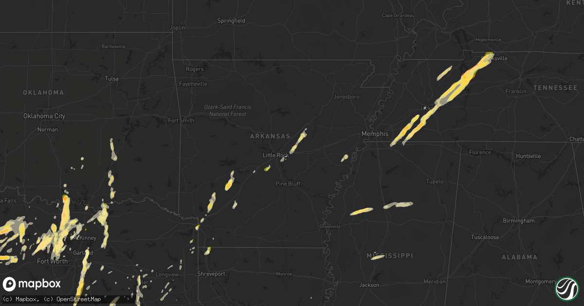
Hail Map in Arkansas on April 8, 2024
Get this storm
April 8 map
$229
one time, instant access
Download today. No call, no setup
Keep the $229
Bought the map and want the full workflow? Apply the entire $229 to a subscription within 7 days. None of it is wasted.
Every map, not just this one
This buys you this map. Subscription and you get every map we run, in the markets you choose from a few cities to whole states to nationwide. Plus real-time alerts the moment a storm fires.
Contact data
Name, contact info, occupancy, even credit band for addresses in the footprint. You go from where it hit to who to call.
Become the source they trust
Unlimited branding weather history reports on demand. You already have the documented answer ready for the property owner, and you are the one who showed up with it.
Property data and RoofTrace estimates
Pull up any address you have got, its value and the exact code rules for that jurisdiction, straight from One Click Code. Then RoofTrace estimates the squares, pitch, and roof value, priced the way you price.
Storm reports in Arkansas
Arkansas
| Date | Description |
|---|---|
| 04/08/20246:49 PM CDT | Report of quarter size hail near texarkana. |
| 04/08/20244:20 PM CDT | Roof removed from a home on hwy 1. |
| 04/08/20245:20 AM CDT | A tree with a waterlogged root system was uprooted onto a home in fouke by non-severe thunderstorm winds. No other damage was noted in the area. |
| 04/07/20248:33 PM CDT | Nws damage survey team determined 80-90 mph wind gusts due to microburst occurred. Several trees were uprooted and several homes were damaged. |
| 04/07/20248:30 PM CDT | Delayed report relayed by the clark county oem. |
| 04/07/20247:31 PM CDT | A local report indicates 1.00 inch wind near 4 SW Sardis |
| 04/07/20247:20 PM CDT | Tree down on hwy 332 south of 278. |
All States Impacted by Hail Map on April 8, 2024
Cities Impacted by Hail Map on April 8, 2024
- Doddsville, MS
- Ruleville, MS
- Schlater, MS
- Minter City, MS
- Philipp, MS
- Vaughan, MS
- Greenwood, MS
- Pickens, MS
- Holcomb, MS
- Goodman, MS
- Camden, MS
- Grenada, MS
- Coffeeville, MS
- Big Creek, MS
- Gore Springs, MS
- Calhoun City, MS
- Conroe, TX
- Vardaman, MS
- Derma, MS
- Hempstead, TX
- Willis, TX
- Chappell Hill, TX
- Bellville, TX
- Houston, MS
- Cleveland, TX
- Coldspring, TX
- New Waverly, TX
- Zavalla, TX
- Huntington, TX
- Waller, TX
- Navasota, TX
- Plantersville, TX
- Pointblank, TX
- San Augustine, TX
- Saint Joseph, LA
- Center, TX
- Montgomery, TX
- Grand Junction, TN
- Moscow, TN
- La Grange, TN
- Somerville, TN
- Hickory Valley, TN
- Whiteville, TN
- Bolivar, TN
- Nacogdoches, TX
- Toone, TN
- Rossville, TN
- Collierville, TN
- Marianna, AR
- Lexa, AR
- Byhalia, MS
- Medon, TN
- Jackson, TN
- Williston, TN
- Bremond, TX
- Pinson, TN
- Buffalo, TX
- Lamar, MS
- Elkhart, TX
- Oakwood, TX
- Oakland, TN
- Beech Bluff, TN
- Cameron, LA
- Mercer, TN
- Jacksonville, TX
- Fairfield, TX
- Kosse, TX
- Rusk, TX
- Palestine, TX
- Huron, TN
- Groesbeck, TX
- Thornton, TX
- Tennessee Colony, TX
- Hackberry, LA
- Teague, TX
- Lexington, TN
- Vivian, LA
- Plain Dealing, LA
- Hosston, LA
- Ida, LA
- Cedar Grove, TN
- Wildersville, TN
- Yuma, TN
- Bartlett, TX
- Bullard, TX
- Marshall, TX
- Brownsville, TN
- Westport, TN
- Buena Vista, TN
- Holladay, TN
- Huntingdon, TN
- Bruceton, TN
- Camden, TN
- Whitehouse, TX
- Athens, TX
- Flint, TX
- Montalba, TX
- Granger, TX
- Jefferson, TX
- Arp, TX
- Tyler, TX
- Bradley, AR
- Hollow Rock, TN
- Tahoka, TX
- Kerens, TX
- Eva, TN
- New Johnsonville, TN
- Waverly, TN
- Big Sandy, TN
- Post, TX
- Justiceburg, TX
- Coahoma, TX
- Hubbard, TX
- Lewisville, AR
- Dawson, TX
- Frost, TX
- Blooming Grove, TX
- Stewart, TN
- Atlanta, TX
- Tennessee Ridge, TN
- Queen City, TX
- Ira, TX
- Fluvanna, TX
- Trenton, TN
- Milan, TN
- Malone, TX
- Purdon, TX
- Humboldt, TN
- Texarkana, TX
- Texarkana, AR
- Eustace, TX
- Snyder, TX
- Barry, TX
- Italy, TX
- Ben Wheeler, TX
- Corsicana, TX
- Ennis, TX
- Bradford, TN
- Atwood, TN
- Erin, TN
- Cumberland City, TN
- Indian Mound, TN
- Palmyra, TN
- Dover, TN
- Woodlawn, TN
- Clarksville, TN
- Fulton, AR
- McKenzie, TN
- Gleason, TN
- Greenfield, TN
- Palmer, TX
- Rice, TX
- Prescott, AR
- Kaufman, TX
- Washington, AR
- Columbus, AR
- Ozan, AR
- Paris, TN
- Henry, TN
- Waxahachie, TX
- Ferris, TX
- Seagoville, TX
- Dallas, TX
- Okolona, AR
- Mesquite, TX
- Balch Springs, TX
- Forney, TX
- Amity, AR
- McCaskill, AR
- Gurdon, AR
- Lonoke, AR
- Hermleigh, TX
- Terrell, TX
- Cottage Grove, TN
- Lancaster, TX
- Sunnyvale, TX
- Jayton, TX
- Aspermont, TX
- Garland, TX
- Nashville, AR
- Murfreesboro, AR
- Rotan, TX
- Chandler, TX
- Rowlett, TX
- Rockwall, TX
- Benton, AR
- Bauxite, AR
- Carlisle, AR
- Puryear, TN
- Mexia, TX
- Caddo Mills, TX
- Quinlan, TX
- Greenville, TX
- Royse City, TX
- Bonnerdale, AR
- Bismarck, AR
- Pearcy, AR
- Ward, AR
- Austin, AR
- Searcy, AR
- Des Arc, AR
- Wylie, TX
- Sachse, TX
- Hamlin, TX
- Griffithville, AR
- Ralls, TX
- Lorenzo, TX
- Roby, TX
- Scott, AR
- McCaulley, TX
- Mabelvale, AR
- Sweetwater, TX
- Malvern, AR
- Wolfe City, TX
- Old Glory, TX
- Higginson, AR
- Celeste, TX
- Crosbyton, TX
- Rule, TX
- Stamford, TX
- Bedford, TX
- North Richland Hills, TX
- Hurst, TX
- Colleyville, TX
- Haskell, TX
- Southlake, TX
- Roanoke, TX
- Flower Mound, TX
- Argyle, TX
- Lewisville, TX
- Slaton, TX
- Keller, TX
- Bailey, TX
- Bonham, TX
- Leonard, TX
- Fort Worth, TX
- Ector, TX
- Denton, TX
- Mckinney, TX
- Celina, TX
- Dodd City, TX
- Ladonia, TX
- Haltom City, TX
- Grapevine, TX
- Batchelor, LA
- Saint Francisville, LA
- Ravenna, TX
- Ivanhoe, TX
- Telephone, TX
- Ponder, TX
- Justin, TX
- Decatur, TX
- Krum, TX
- Avoca, TX
- Weinert, TX
- Gunter, TX
- Haslet, TX
- Sanger, TX
- Valley View, TX
- Bennington, OK
- Frisco, TX
- Little Elm, TX
- Aubrey, TX
- Pilot Point, TX
- Hendrix, OK
- Laneville, TX
- Throckmorton, TX
- Rhome, TX
- Bokchito, OK
- Collinsville, TX
- Gainesville, TX
- Tioga, TX
- Boswell, OK
- Henderson, TX
- Denison, TX
- Moran, TX
- Breckenridge, TX
- Prosper, TX
- Hedley, TX
- Lelia Lake, TX
- Millsap, TX
- Weatherford, TX
- Newcastle, TX
- Liberty, MS
- Era, TX
- Whitesboro, TX
- Poolville, TX
- Quail, TX
- Graham, TX
- Olney, TX
- Loving, TX
- Caddo, TX
- Perrin, TX
- Mineral Wells, TX
- Lueders, TX
- Tatum, TX
- Muenster, TX
- Rosston, TX
- Van Alstyne, TX
- Whitt, TX
- Bryson, TX
- Atoka, OK
- Magnolia, MS
- Osyka, MS
- Caddo, OK
- Albany, TX
- Bridgeport, TX
- Jacksboro, TX
- Springtown, TX
- Marietta, OK
- Lane, OK
- Whitewright, TX
- Sherman, TX
- Tom Bean, TX
- Windthorst, TX
- Sunflower, MS
- Jermyn, TX
- Henrietta, TX
- Azle, TX
- Newark, TX
- Bells, TX
- Savoy, TX
- Boyd, TX
- Thackerville, OK
- Bowie, TX
- Strawn, TX
- Graford, TX
- Ardmore, OK
- Madill, OK
- Stringtown, OK
- Bellevue, TX
- Paradise, TX
- Chico, TX
- Woodson, TX
- Palo Pinto, TX
- Stonewall, OK
- Roff, OK
- Fitzhugh, OK
- Rochester, TX
- Kiowa, OK
- Pittsburg, OK
- Tishomingo, OK
- Nocona, TX
- Gordon, TX
- Ada, OK
- Sunset, TX
- Mill Creek, OK
- Wardville, OK
- Stuart, OK
- Mcalester, OK
- O'Brien, TX
- Sulphur, OK
- Lovington, NM
- Alvord, TX
- Tatum, NM
- Howe, TX
- Plains, TX
- Anna, TX
- Maljamar, NM
- Lake Dallas, TX
- Euless, TX
- Coppell, TX
- Carrollton, TX
- Whiteface, TX
- Andrews, TX
- Kemp, TX
- Fort Campbell, KY
- Seminole, TX
- Lufkin, TX
- Mabank, TX
- Canton, TX
- Wills Point, TX
- Hobbs, NM
- Eunice, NM
- Lamesa, TX
- Welch, TX
- Silverton, TX
- Bivins, TX
- Mineola, TX
- Winona, TX
- Lindale, TX
- Big Sandy, TX
- George West, TX
- Beeville, TX
- Gail, TX
- Odonnell, TX
- Frankston, TX
- Larue, TX
- Brownsboro, TX
- Wilson, TX
- Longview, TX
- Diana, TX
- Alto, TX
- Cushing, TX
- Gause, TX
- Cameron, TX
- Hearne, TX
- Jewett, TX
- Long Branch, TX
- Trenton, TX
- Randolph, TX
- Colbert, OK
- Cartwright, OK


