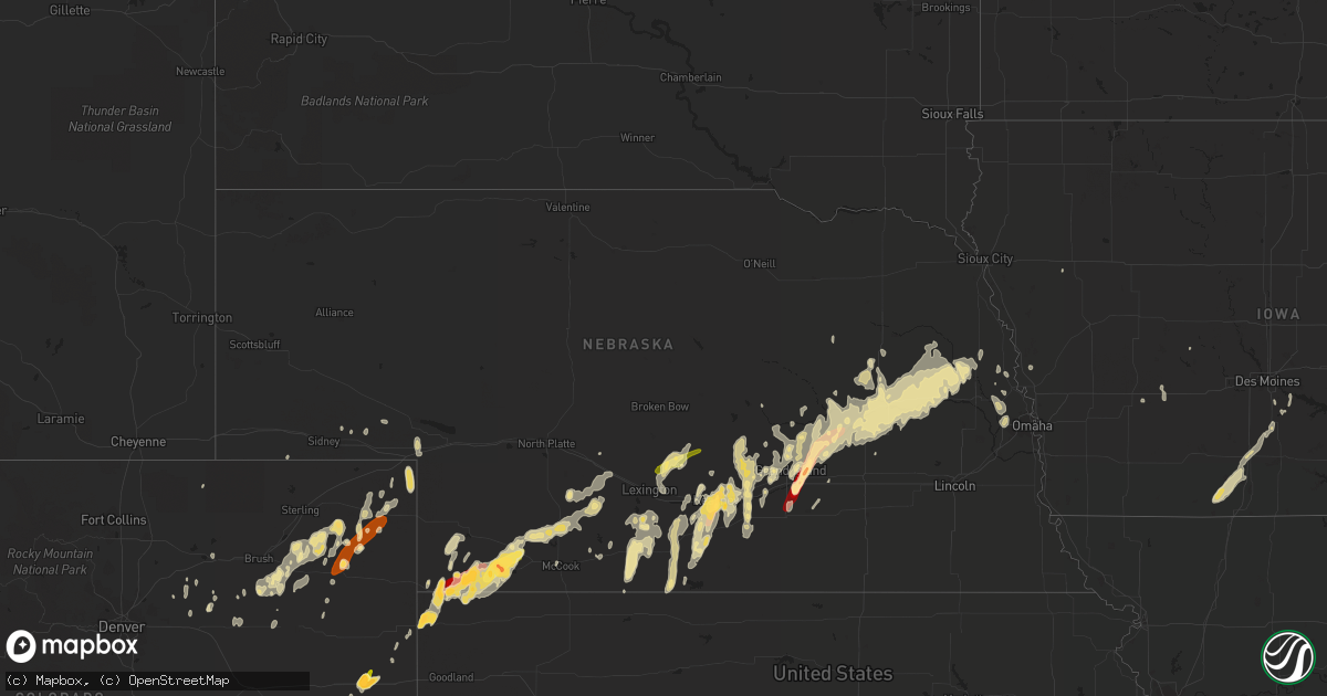
Hail Map in Nebraska on April 8, 2013
Get this storm
April 8 map
$229
one time, instant access
Download today. No call, no setup
Keep the $229
Bought the map and want the full workflow? Apply the entire $229 to a subscription within 7 days. None of it is wasted.
Every map, not just this one
This buys you this map. Subscription and you get every map we run, in the markets you choose from a few cities to whole states to nationwide. Plus real-time alerts the moment a storm fires.
Contact data
Name, contact info, occupancy, even credit band for addresses in the footprint. You go from where it hit to who to call.
Become the source they trust
Unlimited branding weather history reports on demand. You already have the documented answer ready for the property owner, and you are the one who showed up with it.
Property data and RoofTrace estimates
Pull up any address you have got, its value and the exact code rules for that jurisdiction, straight from One Click Code. Then RoofTrace estimates the squares, pitch, and roof value, priced the way you price.
Storm reports in Nebraska
Nebraska
| Date | Description |
|---|---|
| 04/08/20136:21 PM CDT | A local report indicates 59 MPH wind near BIG SPRINGS |
| 04/08/20134:55 AM CDT | A local report indicates 60 MPH wind near NORTH BEND |
| 04/08/20134:19 AM CDT | Quarter size hail as well as very heavy rain. |
| 04/08/20133:27 AM CDT | A local report indicates 1.75 inch wind near PHILLIPS |
| 04/08/20132:49 AM CDT | Covered the ground and lasted for about 5 minutes. |
| 04/08/20132:30 AM CDT | A local report indicates 1.00 inch wind near CENTRAL CITY |
| 04/08/20132:30 AM CDT | Power is out. |
| 04/08/20132:30 AM CDT | Hail covered the ground. |
| 04/08/20132:12 AM CDT | A local report indicates 64 MPH wind near 2 NE NORMAN |
| 04/08/20131:53 AM CDT | At the nws office |
| 04/08/20131:51 AM CDT | Nickel hail mixed with a few quarters. |
| 04/08/20131:49 AM CDT | A local report indicates 58 MPH wind near MCCOOK |
| 04/08/20131:40 AM CDT | A local report indicates 1.00 inch wind near KEARNEY |
| 04/08/20131:19 AM CDT | A local report indicates 1.75 inch wind near KEARNEY |
| 04/08/20131:18 AM CDT | A local report indicates 66 MPH wind near TRENTON |
| 04/08/20131:09 AM CDT | A local report indicates 1.75 inch wind near 6 W GILTNER |
| 04/08/20131:02 AM CDT | Lost power in part of town |
| 04/08/201312:58 AM CDT | Report relayed from the nebraska rainfall assessment and information network. |
| 04/08/201312:56 AM CDT | A lot of tree damage including trees blocking roadways. One outbuilding blown over and a moblie home completely destroyed. Damage at the dorms on the unk campus. Portio |
| 04/08/201312:54 AM CDT | From home weather station |
| 04/08/201312:50 AM CDT | Strong winds to 60 mph damaged two large outbuilding and large tree limbs down. |
| 04/08/201312:45 AM CDT | Estimated time strong winds associated with a thunderstorm blew calf feeders into the ditch. |
| 04/08/201312:40 AM CDT | Power poles and wires down along county road |
| 04/08/201312:40 AM CDT | Power poles and wires down along county road |
| 04/08/201312:40 AM CDT | Emergency manager reported a large metal outbuilding near 733 and q road was destroyed. Time estimated from radar. |
| 04/08/201312:35 AM CDT | Strong winds to 80 mph damaged a home...six buildings and destroyed to large silos. Several pivots were damaged or destroyed. Home owner estimated winds lasted 15 minut |
| 04/08/201312:35 AM CDT | A local report indicates 74 MPH wind near HOLDREGE AIRPORT |
| 04/08/201312:33 AM CDT | Strong winds to 70 mph destroyed two livestock shelters and a metal wind break. |
| 04/08/201312:30 AM CDT | Multiple reports of wind damage to power poles...grain bins and overturned center pivots. Damage occurred early this morning along and south of highway 23 between farna |
| 04/08/201312:30 AM CDT | Strong winds to 80 mph lasted around 15 minutes that destroyed a large pole barn and nine large grain bins. Large tree limbs were down and windows blown out of pickup t |
| 04/08/201312:30 AM CDT | Window blown out and garage door removed by wind |
| 04/08/201312:30 AM CDT | Strong winds to 80 mph took power lines down with 40 power poles snapped and 173 consumers impacted by power outage. |
| 04/08/201312:25 AM CDT | Law enforcement estimated 60 center irrigation pivots overturned or destroyed in an area over 48 square miles to the west and southwest of eustis. The damage extended f |
| 04/08/201312:25 AM CDT | Large metal building destroyed with tin debris from west through northeast of road 741...and tree line wind break damaged. |
| 04/08/201312:23 AM CDT | Quonset building vents damaged and irrigation pipe wrapped over framing. Several four inch or larger diameter tree limbs down. |
| 04/08/201312:20 AM CDT | Semi blown over by wind |
| 04/07/201311:15 PM CDT | Wind gusts estimated at 55 to 60 mph. |
| 04/07/201311:15 PM CDT | Pasture fences and gates blown down. Estimated wind speed of 60 mph. |
| 04/07/201311:06 PM CDT | No funnel visible to spotter. |
| 04/07/201310:52 PM CDT | A local report indicates 1.00 inch wind near 6 SE PALISADE |
| 04/07/201310:50 PM CDT | A local report indicates 1.00 inch wind near 4 S EDDYVILLE |
| 04/07/201310:22 PM CDT | A local report indicates 1.00 inch wind near 6 NNW STRATTON NE |
| 04/07/201310:12 PM CDT | Spotter measured 2 and 3/8 by 1 and 7/8 stones |
| 04/07/201310:04 PM CDT | A local report indicates 1.75 inch wind near STRATTON NE |
| 04/07/20139:45 PM CDT | Extensive damage to a farm and feed yard...including destroyed buildings...grain bins...cars and trucks. Power poles and large trees snapped. Debris hanging on power li |
| 04/07/20139:18 PM CDT | A local report indicates 1.75 inch wind near 3 NNE BENKELMAN |
| 04/07/20139:15 PM CDT | A local report indicates 1.75 inch wind near 2 W PARKS |
| 04/07/20139:09 PM CDT | A local report indicates 1.00 inch wind near BENKELMAN |
Cities Impacted by Hail Map on April 8, 2013
- Madison, NE
- Platte Center, NE
- Humphrey, NE
- Monroe, NE
- Lindsay, NE
- Benkelman, NE
- Parks, NE
- Swan, IA
- Hartford, IA
- Ackworth, IA
- Lena, IL
- Deer Trail, CO
- Grand Island, NE
- Imperial, NE
- Champion, NE
- Fleming, CO
- Schuyler, NE
- Dodge, NE
- Howells, NE
- Rogers, NE
- North Bend, NE
- Riverdale, NE
- Amherst, NE
- Elwood, NE
- Maxwell, NE
- Moorefield, NE
- Keystone, IA
- Belle Plaine, IA
- Luzerne, IA
- Chelsea, IA
- Central City, NE
- Clarks, NE
- Craigville, IN
- Geneva, IN
- Monroe, IN
- Bluffton, IN
- Decatur, IN
- Berne, IN
- Camden, IN
- Phillips, NE
- Sumner, NE
- Akron, CO
- Columbus, NE
- Shelby, NE
- Smithfield, NE
- Hordville, NE
- Scribner, NE
- Stromsburg, NE
- Oakland, NE
- Giltner, NE
- Chapman, NE
- Aurora, NE
- Bruno, NE
- Hooper, NE
- West Point, NE
- Osceola, NE
- Genoa, NE
- Doniphan, NE
- Saint Paul, NE
- Clarkson, NE
- Leigh, NE
- Fullerton, NE
- Marquette, NE
- Archer, NE
- Linwood, NE
- Bellwood, NE
- Saint Libory, NE
- Polk, NE
- Morse Bluff, NE
- Rising City, NE
- Palmer, NE
- Uehling, NE
- Duncan, NE
- Ames, NE
- David City, NE
- Snyder, NE
- Silver Creek, NE
- Big Springs, NE
- Brule, NE
- Wood River, NE
- Kearney, NE
- Haigler, NE
- Fowler, IN
- Kellerton, IA
- Van Wert, IA
- Grand River, IA
- Ellston, IA
- Osceola, IA
- Hayes Center, NE
- Maywood, NE
- Curtis, NE
- McCook, NE
- Funk, NE
- Poneto, IN
- Saint Francis, KS
- Bertrand, NE
- Lamoni, IA
- Murray, IA
- Mount Ayr, IA
- Julesburg, CO
- Axtell, NE
- Roggen, CO
- Oxford, NE
- Edison, NE
- Max, NE
- Trenton, NE
- Stratton, NE
- Palisade, NE
- Yuma, CO
- Elm Creek, NE
- Kennard, NE
- Blair, NE
- Herman, NE
- Cambridge, NE
- Bartley, NE
- Haxtun, CO
- Tilden, NE
- Petersburg, NE
- Bird City, KS
- Bethune, CO
- Stratton, CO
- Shelton, NE
- Thomson, IL
- Fulton, IL
- Clinton, IA
- Otis, CO
- Woodrow, CO
- Monmouth, IA
- Adair, IA
- Holyoke, CO
- Orleans, NE
- Atlanta, NE
- Holdrege, NE
- Loomis, NE
- Hartwick, IA
- Overton, NE
- Eddyville, NE
- Oconto, NE
- Miller, NE
- Mason City, NE
- Alda, NE
- Cairo, NE
- Byers, CO
- Craig, NE
- Lanark, IL
- Shannon, IL
- Arlington, NE
- Brush, CO
- Alma, NE
- Strasburg, CO
- Rockville, NE
- Ravenna, NE
- Indianola, IA
- Vona, CO
- Norton, KS
- Wilsonville, NE
- Minden, NE
- Gibbon, NE
- Sterling, CO
- Valley, NE
- Bennington, NE
- Washington, NE
- Elkhorn, NE
- Farnam, NE
- Cedar Rapids, IA
- New Virginia, IA
- Ovid, CO
- Arapahoe, NE
- Hendley, NE
- Beaver City, NE
- Omaha, NE
- Wray, CO
- Van Horne, IA
- Saint Edward, NE
- Gothenburg, NE
- Scotia, NE
- Heartwell, NE
- Kenesaw, NE
- Weldon, IA
- Brookston, IN
- Wilcox, NE
- Republican City, NE
- Anita, IA
- Atlantic, IA
- Blairstown, IA
- Elberon, IA
- Marengo, IA
- Elizabeth, IL
- Galena, IL
- Hanover, IL
- Keenesburg, CO
- Stockville, NE
- Lexington, NE
- Fremont, NE
- McDonald, KS
- Holbrook, NE
- Wisner, NE
- Stamford, NE
- Odessa, NE
- Wiggins, CO
- Warren, IN
- Walton, IN
- Galveston, IN
- Logansport, IN
- Lucas, IA
- Hampton, NE
- Solon, IA
- North Liberty, IA
- Long Island, KS
- Indianola, NE
- Liberty Center, IN
- Hastings, NE
- Trumbull, NE
- Eustis, NE
- Paoli, CO
- Lindon, CO
- Fairfax, IA
- Idalia, CO
- Holstein, IA
- Battle Creek, IA
- Chappell, NE
- Lodgepole, NE
- Harvard, NE
- Dannebrog, NE
- Beemer, NE
- Boelus, NE
- Milo, IA
- Sidney, NE
- Grover, CO
- Pleasanton, NE
- Oshkosh, NE
- Bennett, CO
- Missouri Valley, IA
- Mondamin, IA
- Modale, IA
- Yale, IA
- Bagley, IA
- Fort Morgan, CO
- Bernard, IA
- Iowa City, IA
- Palo, IA
- Shellsburg, IA
- Vinton, IA
- Pleasant Hill, IA
- Burlington, CO
- Brady, NE
- Cozad, NE
- Bellevue, IA
- North Ridgeville, OH
- Milan, OH
- Berlin Heights, OH
- Berea, OH
- Amherst, OH
- Elyria, OH
- Grafton, OH
- Strongsville, OH
- Huron, OH
- Columbia Station, OH
- Wakeman, OH
- Norwalk, OH
- Oberlin, OH
- Collins, OH
- Olmsted Falls, OH
- Marion, IA


