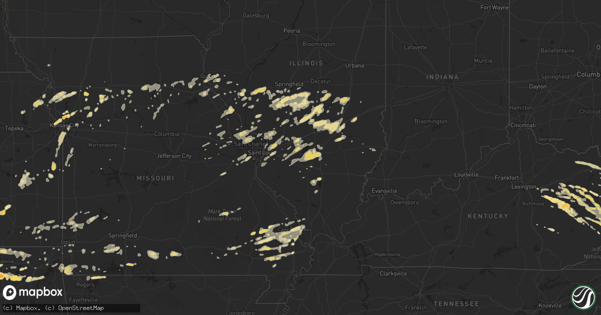
Hail Map in Virginia on April 8, 2011
Get this storm
April 8 map
$229
one time, instant access
Download today. No call, no setup
Keep the $229
Bought the map and want the full workflow? Apply the entire $229 to a subscription within 7 days. None of it is wasted.
Every map, not just this one
This buys you this map. Subscription and you get every map we run, in the markets you choose from a few cities to whole states to nationwide. Plus real-time alerts the moment a storm fires.
Contact data
Name, contact info, occupancy, even credit band for addresses in the footprint. You go from where it hit to who to call.
Become the source they trust
Unlimited branding weather history reports on demand. You already have the documented answer ready for the property owner, and you are the one who showed up with it.
Property data and RoofTrace estimates
Pull up any address you have got, its value and the exact code rules for that jurisdiction, straight from One Click Code. Then RoofTrace estimates the squares, pitch, and roof value, priced the way you price.
Storm reports in Virginia
Virginia
| Date | Description |
|---|---|
| 04/08/20116:52 PM CDT | A few trees down and penny size hail near glade springs. |
| 04/08/20116:42 PM CDT | Bp gas station near interstate 81 draper interchange sustained heavy damage...mobile home overturned. Trees down. |
| 04/08/20116:37 PM CDT | A local report indicates 1.00 inch wind near PULASKI |
| 04/08/20116:35 PM CDT | Large oak tree uprooted and fell on top of house and vehicle on beth scott drive...some large limbs down as well. |
| 04/08/20116:35 PM CDT | Possible tornado. Heavy damagage reported from mt. Olivet area of southwest side of pulaski to draper. Roof off a home on martin street. Law enforcement blocking off st |
| 04/08/20116:35 PM CDT | *** 6 inj *** severe damage...town of pulaski virginia...damage path extends se across interstate 81 at the exit 92 interchange vnty of draper virginia pulaski county. |
| 04/08/20116:35 PM CDT | A local report indicates 1.25 inch wind near PULASKI |
| 04/08/20116:31 PM CDT | A few large trees snapped and minor roof damage to a couple of out buildings on schrader hill road in robinson tract neighborhood. |
| 04/08/201112:05 AM CDT | Quarter size hail at lebanon. Reported by dispatch. |
| 04/07/201110:05 PM CDT | 1 tree down on keno rd |
| 04/07/20119:30 PM CDT | A local report indicates 1.00 inch wind near BLAND |
| 04/07/20119:20 PM CDT | A local report indicates 1.00 inch wind near PULASKI |
| 04/07/20119:05 PM CDT | A local report indicates 1.00 inch wind near 1 SE DUBLIN |
| 04/07/20119:05 PM CDT | A local report indicates 1.00 inch wind near RADFORD |
| 04/07/20118:51 PM CDT | Strong winds also reported. |
| 04/07/20117:36 PM CDT | A local report indicates 1.00 inch wind near 5 E STUART |
| 04/07/20117:20 PM CDT | A local report indicates 1.00 inch wind near MEADOWS OF DAN |
| 04/07/20117:20 PM CDT | A local report indicates 60 MPH wind near MEADOWS OF DAN |
| 04/07/20117:15 PM CDT | Barn damaged and several trees down. |
| 04/07/20117:12 PM CDT | A local report indicates 1.00 inch wind near 2 ESE WILLIS |
| 04/07/20117:02 PM CDT | A local report indicates 1.00 inch wind near INDIAN VALLEY |
All States Impacted by Hail Map on April 8, 2011
Cities Impacted by Hail Map on April 8, 2011
- Richmond, MO
- Fancy Gap, VA
- Hillsville, VA
- Sandy Hook, KY
- Galena, MO
- Highlandville, MO
- Ponce De Leon, MO
- Spokane, MO
- Westphalia, KS
- Eureka, MO
- Pacific, MO
- High Ridge, MO
- Valley Park, MO
- Fenton, MO
- Ballwin, MO
- Saint Louis, MO
- Dexter, MO
- Gower, MO
- Edgerton, MO
- Hamilton, MO
- Whitesville, WV
- Sylvester, WV
- Chelsea, OK
- Macon, MO
- Excello, MO
- Prichard, WV
- Dunlow, WV
- Louisa, KY
- Catlettsburg, KY
- Wayne, WV
- Genoa, WV
- Fort Gay, WV
- Kenova, WV
- Pawnee, IL
- New London, MO
- Hannibal, MO
- Ashton, WV
- Gays, IL
- Sullivan, IL
- Mattoon, IL
- Utica, MO
- Ludlow, MO
- Chillicothe, MO
- Dawn, MO
- Bluejacket, OK
- Cleveland, VA
- Lebanon, VA
- Paola, KS
- Louisburg, KS
- Bucyrus, KS
- Indian Valley, VA
- Claremore, OK
- Oologah, OK
- Pittsfield, IL
- Barry, IL
- Ezel, KY
- Wellington, KY
- Sikeston, MO
- Peck, KS
- Clearwater, KS
- Miami, OK
- Shady Spring, WV
- Jumping Branch, WV
- Cool Ridge, WV
- Nimitz, WV
- White Oak, WV
- Geuda Springs, KS
- Oxford, KS
- Waverly, MO
- Corder, MO
- Pawhuska, OK
- Wynona, OK
- Shelbiana, KY
- Pikeville, KY
- Elkfork, KY
- Fredonia, KS
- Jet, OK
- Cherokee, OK
- Helena, OK
- Goltry, OK
- Buffalo, KS
- Thebes, IL
- Clifton Hill, MO
- Wilsey, KS
- Council Grove, KS
- Jadwin, MO
- Salem, MO
- Ramsey, IL
- Brownstown, IL
- Beecher City, IL
- Swiss, WV
- Clendenin, WV
- Elkview, WV
- Evans, WV
- Bomont, WV
- Indore, WV
- Clay, WV
- Newton, WV
- Charleston, WV
- Gallipolis Ferry, WV
- Bickmore, WV
- Procious, WV
- Amma, WV
- Point Pleasant, WV
- Southside, WV
- Henderson, WV
- Leon, WV
- Liberty, WV
- Kenna, WV
- Walton, WV
- Left Hand, WV
- Ripley, WV
- Given, WV
- Looneyville, WV
- Gandeeville, WV
- Summersville, WV
- Gallipolis, OH
- Marble Hill, MO
- Norwich, KS
- Essex, MO
- Bloomfield, MO
- Dudley, MO
- Chaffee, MO
- Scott City, MO
- Benton, MO
- Fairview, OK
- Longdale, OK
- Ponca City, OK
- Newkirk, OK
- Tonkawa, OK
- Braman, OK
- Nardin, OK
- Kaw City, OK
- Blackwell, OK
- Pineville, WV
- Branchland, WV
- Pecks Mill, WV
- Wyoming, WV
- Holden, WV
- Lake, WV
- Clear Fork, WV
- Matheny, WV
- Davin, WV
- Cyclone, WV
- Wilsondale, WV
- Rock, WV
- Yolyn, WV
- Chapmanville, WV
- Stollings, WV
- Man, WV
- Dingess, WV
- Harts, WV
- Ranger, WV
- Mallory, WV
- Kiahsville, WV
- Herndon, WV
- Brenton, WV
- Jesse, WV
- Oceana, WV
- Bim, WV
- Bluefield, WV
- Lyburn, WV
- Breeden, WV
- Coal Mountain, WV
- Fanrock, WV
- Montcalm, WV
- Amherstdale, WV
- Northfork, WV
- Logan, WV
- Asheboro, NC
- Denton, NC
- Trinity, NC
- Braymer, MO
- West Liberty, KY
- Agency, MO
- Faucett, MO
- Dearborn, MO
- Salyersville, KY
- Hagerhill, KY
- Oil Springs, KY
- Illinois City, IL
- Taylor Ridge, IL
- Derby, KS
- Wichita, KS
- Payson, IL
- Liberty, IL
- Belle Plaine, KS
- Mayfield, KS
- Mulvane, KS
- Wellington, KS
- Arkansas City, KS
- Winfield, KS
- Rowdy, KY
- Clayhole, KY
- Lost Creek, KY
- Inez, KY
- Williamson, WV
- La Cygne, KS
- Fontana, KS
- Manchester, OK
- Edinburg, IL
- Rochester, IL
- Mechanicsburg, IL
- Silva, MO
- Tyner, KY
- Manchester, KY
- Annville, KY
- Sextons Creek, KY
- Auburn, IL
- Virden, IL
- Divernon, IL
- Crum, WV
- Warfield, KY
- Nokomis, IL
- Hillsboro, IL
- Irving, IL
- Pana, IL
- Witt, IL
- Oconee, IL
- Bingham, IL
- Fillmore, IL
- Tower Hill, IL
- Shelbyville, IL
- Assumption, IL
- Thayer, IL
- Girard, IL
- Palmyra, IL
- Bulpitt, IL
- Stonington, IL
- Kincaid, IL
- Taylorville, IL
- Overland Park, KS
- Leawood, KS
- Stilwell, KS
- Kansas City, MO
- Belton, MO
- Douglass, KS
- Garfield, AR
- Eureka Springs, AR
- Nash, OK
- Farmersville, IL
- Morrisonville, IL
- Owaneco, IL
- Palmer, IL
- Fraziers Bottom, WV
- Glenwood, WV
- Clarksville, MO
- Louisville, IL
- Dublin, VA
- Radford, VA
- Fall River, KS
- Willis, VA
- Laurel Fork, VA
- Dugspur, VA
- Vanzant, MO
- Dora, MO
- Atlanta, KS
- Winston Salem, NC
- Anthony, KS
- Gunlock, KY
- Seth, WV
- Madison, WV
- Altamont, IL
- Effingham, IL
- Forsyth, MO
- Jacksonville, IL
- Barnsdall, OK
- Skiatook, OK
- Ramona, OK
- Sheldon, MO
- Cannel City, KY
- Royalton, KY
- Hazel Green, KY
- Mize, KY
- Prestonsburg, KY
- Hueysville, KY
- Eastern, KY
- Garrett, KY
- Kearney, MO
- Liberty, MO
- Jonesboro, IL
- Jonesborough, TN
- Lakewood, IL
- Hardin, MO
- Rushville, MO
- Harold, KY
- Grethel, KY
- Banner, KY
- Leburn, KY
- Saulsville, WV
- Whitesburg, KY
- Harper, KS
- Milan, KS
- Collinsville, OK
- Medford, OK
- Conway Springs, KS
- Cleo Springs, OK
- Benton, KS
- Caldwell, KS
- Shidler, OK
- Carrier, OK
- Udall, KS
- Burlington, OK
- Mcconnell Afb, KS
- Rose Hill, KS
- Deer Creek, OK
- Potwin, KS
- Talala, OK
- Enid, OK
- Augusta, KS
- Lamont, OK
- Danville, KS
- Rock, KS
- South Haven, KS
- Carmen, OK
- Dexter, KS
- Fairfax, OK
- Andover, KS
- Towanda, KS
- Ringwood, OK
- Haysville, KS
- Burden, KS
- Waldron, KS
- Meno, OK
- Burns, KS
- Pond Creek, OK
- Ochelata, OK
- Bluff City, KS
- Amorita, OK
- Freeport, KS
- Burbank, OK
- El Dorado, KS
- Bartlesville, OK
- Argonia, KS
- Aline, OK
- Wakita, OK
- Saint Charles, MO
- Greenville, MO
- Glenallen, MO
- Culloden, WV
- Barboursville, WV
- Milton, WV
- Ona, WV
- Greenup, IL
- Toledo, IL
- Jewett, IL
- Hidalgo, IL
- Montrose, IL
- Alhambra, IL
- Edwardsville, IL
- Turney, MO
- Plattsburg, MO
- Cameron, MO
- Osborn, MO
- East Point, KY
- Fairmont, OK
- Hunter, OK
- Red Rock, OK
- Billings, OK
- Garber, OK
- Carrollton, MO
- Norborne, MO
- Cedar Point, KS
- Brussels, IL
- O'Fallon, MO
- Old Monroe, MO
- Winfield, MO
- Golden Eagle, IL
- Batchtown, IL
- Kermit, WV
- Tomahawk, KY
- Mason, IL
- Watson, IL
- Saint Elmo, IL
- Flatgap, KY
- Jackson, KY
- Tovey, IL
- Harvel, IL
- Modesto, IL
- Waverly, IL
- Leon, KS
- Milan, IL
- Andalusia, IL
- Salt Rock, WV
- Huntington, WV
- Cottage Hills, IL
- Alton, IL
- Bethalto, IL
- Dorsey, IL
- Moro, IL
- Delbarton, WV
- Matewan, WV
- Marland, OK
- Jasper, MO
- Carthage, MO
- Branson, MO
- Kissee Mills, MO
- Rockaway Beach, MO
- Kirbyville, MO
- Stanton, KY
- Clay City, KY
- Tamaroa, IL
- Pinckneyville, IL
- Howard, KS
- Severy, KS
- Pinnacle, NC
- King, NC
- Lowgap, NC
- Mount Airy, NC
- Winchester, IL
- Milton, IL
- Pearl, IL
- Eureka, KS
- Gilbert, WV
- Baisden, WV
- Marine, IL
- Campton, KY
- Printer, KY
- McDowell, KY
- Teaberry, KY
- Drift, KY
- Dana, KY
- Billings, MO
- Isabella, OK
- Odessa, MO
- White Hall, IL
- Hillview, IL
- Eolia, MO
- Pleasant Hill, IL
- Nebo, IL
- Bowling Green, MO
- Ava, MO
- Squires, MO
- Powersite, MO
- Taneyville, MO
- Bucklin, MO
- New Cambria, MO
- Crown City, OH
- Apple Grove, WV
- Colony, KS
- Lowmansville, KY
- Rockbridge, IL
- Kane, IL
- Carrollton, IL
- Pierce City, MO
- Stark City, MO
- Ararat, NC
- Pilot Mountain, NC
- Siloam, NC
- Bevier, MO
- Salisbury, MO
- Callao, MO
- Marceline, MO
- Dunbar, WV
- Nitro, WV
- Saint Albans, WV
- South Charleston, WV
- Gipsy, MO
- Wappapello, MO
- Zalma, MO
- McGee, MO
- Mouthcard, KY
- Patton, MO
- Spruce Pine, NC
- Moweaqua, IL
- Dalton City, IL
- Beattyville, KY
- Denniston, KY
- Frenchburg, KY
- Anderson, MO
- Noel, MO
- Gray Summit, MO
- Villa Ridge, MO
- Panther, WV
- Mohawk, WV
- Wright City, MO
- Warrenton, MO
- Marthasville, MO
- Centerville, KS
- Mound City, KS
- Hinton, WV
- Forest Hill, WV
- Belleview, MO
- Maywood, MO
- Philadelphia, MO
- Monroe City, MO
- Emden, MO
- Mutual, OK
- Seiling, OK
- Chester, OK
- Bastian, VA
- Camp Point, IL
- Sparta, MO
- Ballard, WV
- Saint Clair, MO
- Sullivan, MO
- Parsons, KS
- Meadowview, VA
- Glade Spring, VA
- Chilhowie, VA
- Florence, KS
- Alma, KS
- Strong City, KS
- Marion, KS
- Lincolnville, KS
- Burdick, KS
- Alta Vista, KS
- Elmdale, KS
- Cottonwood Falls, KS
- Willow Springs, MO
- West Plains, MO
- Brookfield, MO
- Sumner, MO
- Mendon, MO
- Richview, IL
- Ashley, IL
- Stokesdale, NC
- Rocky Comfort, MO
- Beckley, WV
- Crab Orchard, WV
- Jerseyville, IL
- Pulaski, VA
- Hiwassee, VA
- Hurley, VA
- Iaeger, WV
- Baylis, IL
- Dewey, OK
- Copan, OK
- Wann, OK
- McClure, IL
- Cape Girardeau, MO
- Oswego, KS
- Garnett, KS
- Greenville, IL
- De Witt, MO
- Bosworth, MO
- Brunswick, MO
- Triplett, MO
- Pocahontas, IL
- Highland, IL
- Draper, VA
- Jackson, MO
- Rocky Gap, VA
- Narrows, VA
- Lodi, MO
- Clubb, MO
- Madison, MO
- Rhodell, WV
- Odd, WV
- Bogard, MO
- Tobaccoville, NC
- Grove, OK
- South West City, MO
- Powell, MO
- Washburn, MO
- Exeter, MO
- Smithboro, IL
- Mascoutah, IL
- Breese, IL
- Aviston, IL
- Keyesport, IL
- Carlyle, IL
- Trenton, IL
- New Baden, IL
- Germantown, IL
- Rhineland, MO
- Jonesburg, MO
- Hermann, MO
- Farina, IL
- Silex, MO
- Sod, WV
- Alum Creek, WV
- Hurricane, WV
- Tornado, WV
- Princeton, WV
- Spanishburg, WV
- Kegley, WV
- Odin, IL
- Sandoval, IL
- Centralia, IL
- Hoffman, IL
- Salem, IL
- Winchester, KY
- Portage Des Sioux, MO
- West Alton, MO
- Godfrey, IL
- Elsah, IL
- Dow, IL
- Tazewell, VA
- War, WV
- Squire, WV
- Bandy, VA
- North Tazewell, VA
- Berwind, WV
- Bethany, IL
- Lanagan, MO
- Pineville, MO
- Bland, VA
- Lenapah, OK
- Oran, MO
- Chatham, IL
- Springfield, IL
- Glenarm, IL
- Williamsville, MO
- Langley, KY
- Franklin, IL
- Dieterich, IL
- Teutopolis, IL
- Marion, NC
- Cummings, KS
- Atchison, KS
- Scheller, IL
- Kingston, MO
- Black, MO
- New Haven, MO
- Berryville, AR
- Grayson, KY
- Hale, MO
- Polo, MO
- Joplin, MO
- Bonnie, IL
- Delaware, OK
- Riverside, MO
- Kansas City, KS
- Ralston, OK
- Puxico, MO
- Saint Peters, MO
- Lawson, MO
- Advance, MO
- Palmyra, MO
- Hunnewell, MO
- Riner, VA
- Drexel, MO
- Adrian, MO
- Windsor, IL
- Davenport, IA
- Rock Island, IL
- Moline, IL
- East Moline, IL
- Noble, IL
- Newton, IL
- Sumner, IL
- Dadeville, MO
- Aldrich, MO
- Emmalena, KY
- Bulan, KY
- Wildwood, MO
- Liberal, MO
- Golden City, MO
- Lamar, MO
- Salt Lick, KY
- Hull, IL
- Plainville, IL
- Keaton, KY
- Sitka, KY
- Rothville, MO
- Jenkins, KY
- Bixby, MO
- Loami, IL
- Bunker Hill, IL
- Excelsior Springs, MO
- Telford, TN
- Foristell, MO
- Nashville, IL
- Glen Carbon, IL
- Maryville, IL
- Collinsville, IL
- Cowden, IL
- Bluffs, IL
- Griggsville, IL
- Amsterdam, MO
- Pine Top, KY
- Foley, MO
- Olympia, KY
- Moberly, MO
- Parker, KS
- Crane, MO
- Marionville, MO
- Clever, MO
- Nixa, MO
- Canton, OK
- Hewett, WV
- Davy, WV
- Henlawson, WV
- Worden, IL
- Lesterville, MO
- Litchfield, IL
- Mount Olive, IL
- Vinita, OK
- Huntsville, MO
- Blue River, KY
- Aurora, MO
- Woodlawn, IL
- Pearisburg, VA
- Chesapeake, OH
- Taylor, MO
- Quincy, IL
- Fowler, IL
- Afton, OK
- Ashmore, IL
- Harrisonville, MO
- Madison, KS
- Mayview, MO
- Higginsville, MO
- Alma, IL
- Patoka, IL
- Wyandotte, OK
- Fairland, OK
- Pryor, OK
- Adair, OK
- Emerson, KY
- Olive Hill, KY
- Vanceburg, KY
- Rush, KY
- Argillite, KY
- Greensboro, NC
- Valley Falls, KS
- Floyd, VA
- Oldfield, MO
- Chadwick, MO
- Greenville, WV
- Oronogo, MO
- Mindenmines, MO
- Reeds Spring, MO
- Ararat, VA
- Rogers, AR
- Pea Ridge, AR
- Jeffersonville, KY
- Mount Sterling, KY
- Smithville, MO
- Ghent, WV
- Dante, VA
- Haysi, VA
- Honaker, VA
- Bee, VA
- Means, KY
- Woolwine, VA
- Austinville, VA
- New Berlin, IL
- Freeman, MO
- Peculiar, MO
- Allen, KY
- Martin, KY
- Greenfield, MO
- Arcola, MO
- Neoga, IL
- Grandin, MO
- Peterstown, WV
- Lindside, WV
- Goodman, MO
- Tiff City, MO
- Stambaugh, KY
- Wittensville, KY
- Dupo, IL
- Belleville, IL
- Millstadt, IL
- East Saint Louis, IL
- East Carondelet, IL
- Higbee, MO
- Fayette, MO
- Cherryvale, KS
- Clothier, WV
- Jeffrey, WV
- Eskdale, WV
- Danville, WV
- Irvine, KY
- Rogers, KY
- Slade, KY
- Pine Ridge, KY
- Zoe, KY
- Vancleve, KY
- Ashcamp, KY
- Shelby Gap, KY
- Clintwood, VA
- Tina, MO
- Piedmont, KS
- Grenola, KS
- Wolf Lake, IL
- Hoyleton, IL
- Pfafftown, NC
- East Bend, NC
- Bell City, MO
- Le Roy, KS
- McCune, KS
- Girard, KS
- Pittsburg, KS
- Tamms, IL
- Whitewater, MO
- Eskridge, KS
- Galax, VA
- Murrayville, IL
- Roodhouse, IL
- Sedalia, MO
- Clinchco, VA
- Betsy Layne, KY
- Weeksbury, KY
- Bevinsville, KY
- Garner, KY
- Birchleaf, VA
- Morehead, KY
- Davenport, VA
- Damascus, VA
- Minnie, KY
- Hellier, KY
- Tram, KY
- Ivel, KY
- Lackey, KY
- David, KY
- Castlewood, VA
- Dema, KY
- Abingdon, VA
- Owingsville, KY
- Wheelwright, KY
- Vest, KY
- Virgie, KY
- Bypro, KY
- Elkhorn City, KY
- Mousie, KY
- Wayland, KY
- Topmost, KY
- Melvin, KY
- Hi Hat, KY
- Raven, KY
- Robinson Creek, KY
- Beaver, KY
- Saltville, VA
- Nowata, OK
- Troy, MO
- Hawk Point, MO
- Prairie Village, KS
- Summerfield, NC
- New Canton, IL
- Weston, MO
- Fairview Heights, IL
- Caseyville, IL
- O'Fallon, IL
- Sesser, IL
- Montgomery, WV
- Bakersville, NC
- Erwin, TN
- Green Mountain, NC
- Alkol, WV
- Dalton, MO
- Gauley Bridge, WV
- Quapaw, OK
- Fieldon, IL
- Grafton, IL
- Moscow Mills, MO
- Neosho, MO
- Seneca, MO
- Poplar Bluff, MO
- Fisk, MO
- Blue Grass, IA
- Raymond, IL
- Wharncliffe, WV
- McCarr, KY
- Lovely, KY
- Raysal, WV
- Lenore, WV
- Jolo, WV
- Pipestem, WV
- Franklin, MO
- Vernon, IL
- Vandalia, IL
- Meadows Of Dan, VA
- Waukomis, OK
- Meredosia, IL
- Burnsville, NC
- Waltonville, IL
- Bernie, MO
- Foster, WV
- Julian, WV
- Oak Ridge, MO
- Granite City, IL
- Troy, IL
- Mulkeytown, IL
- Christopher, IL
- Benton, IL
- Buckner, IL
- High Hill, MO
- New Florence, MO
- Rayville, MO
- Buffalo, WV
- Carlinville, IL
- Shipman, IL
- Welda, KS
- Neosho Falls, KS
- Dixie, WV
- Belva, WV
- Bartelso, IL
- Walnut Hill, IL
- Okawville, IL
- Albers, IL
- Kell, IL
- Addieville, IL
- Chambersburg, IL
- Strang, OK
- Big Cabin, OK
- Stewardson, IL
- Bolckow, MO
- Winchester, KS
- Asbury, MO
- Humboldt, IL
- Boons Camp, KY
- Paintsville, KY
- Spavinaw, OK
- Rural Hall, NC
- Shelbyville, MO
- Kincaid, KS
- Caputa, SD
- Rapid City, SD
- Noble, MO
- Wasola, MO
- Independence, MO
- Sibley, MO
- Clarence, MO
- Windsor, MO
- Saint Jacob, IL
- Hazard, KY
- Winona, MO
- Alton, MO
- Opolis, KS
- Cassville, MO
- Proctorville, OH
- South Point, OH
- Olney, IL
- Findlay, IL
- Morrisville, MO
- Brighton, MO
- Amigo, WV
- Stephenson, WV
- Mullens, WV
- Glen Fork, WV
- Switzer, WV
- East Lynn, WV
- New Richmond, WV
- Ansted, WV
- Walnut Cove, NC
- Pine Hall, NC
- Madison, NC
- Burlington, KS
- Hominy, OK
- Paynesville, WV
- Mill Spring, MO
- Ozark, MO
- Denton, KY
- De Kalb, MO
- Bidwell, OH
- Clinton, MO
- Lebanon, IL
- Wentzville, MO
- Diamond, MO
- Scammon, KS
- Cherokee, KS
- Pocahontas, VA
- Bluefield, VA
- Falls Mills, VA
- Van Buren, MO
- Ellsinore, MO
- Robertsville, MO
- Catawissa, MO
- Ceres, VA
- Hindman, KY
- Lowndes, MO
- Weir, KS
- Gerald, MO
- Owensville, MO
- Lockwood, MO
- Ridgeway, VA
- Butler, MO
- Stewartsville, MO
- Blaine, KY
- Webbville, KY
- Adams, KY
- Lewisville, NC
- Archie, MO
- Griffithsville, WV
- Itmann, WV
- Twilight, WV
- Wharton, WV
- Buckner, MO
- Kremlin, OK
- Mount Vernon, IL
- Butler, IL
- Shumway, IL
- Wheeler, IL
- Sigel, IL
- Taylor Springs, IL
- Saint Francisville, IL
- Bridgeport, IL
- Cowen, WV
- Pond Gap, WV
- Mammoth, WV
- Blount, WV
- Benld, IL
- Sawyerville, IL
- Gillespie, IL
- Orlando, KY
- Golden, MO
- Eagle Rock, MO
- Marquand, MO
- Burfordville, MO
- Millersville, MO
- Chesterfield, MO
- Labadie, MO
- Lathrop, MO
- Calhoun, IL
- Columbus, KS
- Wellington, MO
- Limestone, TN
- Fall Branch, TN
- Chuckey, TN
- Walshville, IL
- Kinderhook, IL
- Frankford, MO
- Rural Retreat, VA
- Wytheville, VA
- Atkins, VA
- McKee, KY
- Fremont, MO
- Stuart, VA
- New Salem, IL
- Anabel, MO
- Dennis, KS
- Welch, OK
- Waterloo, IL
- Columbia, IL
- Hettick, IL
- Center, MO
- East Alton, IL
- Shelbina, MO
- Blue Mound, KS
- Monett, MO
- Jerico Springs, MO
- Macon, IL
- Marion, VA
- Wood River, IL
- Ravenna, KY
- Williamsburg, KS
- Matoaka, WV
- Hanover, WV
- Simon, WV
- Ravencliff, WV
- Maben, WV
- Freeman, WV
- Lashmeet, WV
- Big Creek, WV
- Spurlockville, WV
- Bramwell, WV
- Beeson, WV
- Miami, MO
- Marshall, MO
- Welch, WV
- Anawalt, WV
- Drury, MO
- Brixey, MO
- Oak Hill, OH


