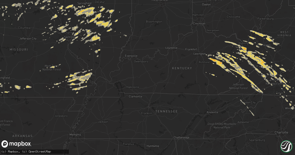
Hail Map on April 8, 2011
Get this storm
April 8 map
$229
one time, instant access
Download today. No call, no setup
Keep the $229
Bought the map and want the full workflow? Apply the entire $229 to a subscription within 7 days. None of it is wasted.
Every map, not just this one
This buys you this map. Subscription and you get every map we run, in the markets you choose from a few cities to whole states to nationwide. Plus real-time alerts the moment a storm fires.
Contact data
Name, contact info, occupancy, even credit band for addresses in the footprint. You go from where it hit to who to call.
Become the source they trust
Unlimited branding weather history reports on demand. You already have the documented answer ready for the property owner, and you are the one who showed up with it.
Property data and RoofTrace estimates
Pull up any address you have got, its value and the exact code rules for that jurisdiction, straight from One Click Code. Then RoofTrace estimates the squares, pitch, and roof value, priced the way you price.
States Impacted by Hail Map on April 8, 2011
Storm reports
Illinois
| Date | Description |
|---|---|
| 04/08/20115:40 AM CDT | A local report indicates 1.00 inch wind near GLEN CARBON |
| 04/08/20115:05 AM CDT | A local report indicates 1.00 inch wind near 1 W GIRARD |
| 04/08/20115:05 AM CDT | A local report indicates 1.00 inch wind near GIRARD |
| 04/08/20114:05 AM CDT | A local report indicates 1.00 inch wind near GIRARD |
| 04/08/20113:50 AM CDT | A local report indicates 1.50 inch wind near VIRDEN |
Virginia
| Date | Description |
|---|---|
| 04/08/20116:52 PM CDT | A few trees down and penny size hail near glade springs. |
| 04/08/20116:42 PM CDT | Bp gas station near interstate 81 draper interchange sustained heavy damage...mobile home overturned. Trees down. |
| 04/08/20116:37 PM CDT | A local report indicates 1.00 inch wind near PULASKI |
| 04/08/20116:35 PM CDT | A local report indicates 1.25 inch wind near PULASKI |
| 04/08/20116:35 PM CDT | Possible tornado. Heavy damagage reported from mt. Olivet area of southwest side of pulaski to draper. Roof off a home on martin street. Law enforcement blocking off st |
| 04/08/20116:35 PM CDT | Large oak tree uprooted and fell on top of house and vehicle on beth scott drive...some large limbs down as well. |
| 04/08/20116:35 PM CDT | *** 6 inj *** severe damage...town of pulaski virginia...damage path extends se across interstate 81 at the exit 92 interchange vnty of draper virginia pulaski county. |
| 04/08/20116:31 PM CDT | A few large trees snapped and minor roof damage to a couple of out buildings on schrader hill road in robinson tract neighborhood. |
| 04/08/201112:05 AM CDT | Quarter size hail at lebanon. Reported by dispatch. |
| 04/07/201110:05 PM CDT | 1 tree down on keno rd |
| 04/07/20119:30 PM CDT | A local report indicates 1.00 inch wind near BLAND |
| 04/07/20119:20 PM CDT | A local report indicates 1.00 inch wind near PULASKI |
| 04/07/20119:05 PM CDT | A local report indicates 1.00 inch wind near RADFORD |
| 04/07/20119:05 PM CDT | A local report indicates 1.00 inch wind near 1 SE DUBLIN |
| 04/07/20118:51 PM CDT | Strong winds also reported. |
| 04/07/20117:36 PM CDT | A local report indicates 1.00 inch wind near 5 E STUART |
| 04/07/20117:20 PM CDT | A local report indicates 60 MPH wind near MEADOWS OF DAN |
| 04/07/20117:20 PM CDT | A local report indicates 1.00 inch wind near MEADOWS OF DAN |
| 04/07/20117:15 PM CDT | Barn damaged and several trees down. |
| 04/07/20117:12 PM CDT | A local report indicates 1.00 inch wind near 2 ESE WILLIS |
| 04/07/20117:02 PM CDT | A local report indicates 1.00 inch wind near INDIAN VALLEY |
Kentucky
| Date | Description |
|---|---|
| 04/08/20116:52 PM CDT | A local report indicates 1.75 inch wind near 1 N CAMPTON |
| 04/08/20116:30 PM CDT | A local report indicates 1.75 inch wind near 2 ESE STANTON |
| 04/08/20116:10 PM CDT | Golf ball hail falling on happy top road. |
| 04/08/20116:09 PM CDT | A local report indicates 1.00 inch wind near STANTON |
| 04/08/20116:06 PM CDT | A local report indicates 1.25 inch wind near STANTON |
| 04/08/20116:05 PM CDT | A local report indicates 1.00 inch wind near CLAY CITY |
| 04/08/20116:00 PM CDT | A local report indicates 1.25 inch wind near CLAY CITY |
| 04/08/20115:25 PM CDT | A local report indicates 1.00 inch wind near 2 SE MOUTHCARD |
| 04/08/20115:02 PM CDT | Dorton creek road off of hwy 23. |
| 04/08/20114:55 PM CDT | A local report indicates 1.50 inch wind near MELVIN |
| 04/08/20113:45 PM CDT | A local report indicates 1.50 inch wind near CROCKETT |
| 04/08/20113:41 PM CDT | A local report indicates 1.00 inch wind near RELIEF |
| 04/08/20113:27 PM CDT | 5144 hwy 1022 |
| 04/08/20113:05 PM CDT | A local report indicates 1.00 inch wind near GRAYSON |
| 04/07/201111:08 PM CDT | A local report indicates 1.00 inch wind near CLAYHOLE |
| 04/07/201110:59 PM CDT | Quarter size hail was reported by the public. |
| 04/07/201110:42 PM CDT | A local report indicates 1.00 inch wind near 2 S CAMPTON |
| 04/07/201110:20 PM CDT | Huge limbs and branches on ky 715. |
| 04/07/201110:20 PM CDT | Huge limbs and branches on big andy road. |
| 04/07/201110:08 PM CDT | The hail was bigger than quarters |
| 04/07/20119:51 PM CDT | A local report indicates 1.00 inch wind near 3 S ROYALTON |
| 04/07/20119:49 PM CDT | A local report indicates 1.00 inch wind near 2 W PIKEVILLE |
| 04/07/20119:37 PM CDT | Nickel to quarter size hail was falling near the junction of routes 30 and 1090. |
| 04/07/20118:57 PM CDT | A local report indicates 1.50 inch wind near 1 W PAINTSVILLE |
Missouri
| Date | Description |
|---|---|
| 04/08/20116:50 AM CDT | 1 inch hail reported 5 miles east of benton missouri in scott county |
| 04/08/20116:42 AM CDT | A local report indicates 1.00 inch wind near FORSYTH |
| 04/08/20116:34 AM CDT | 1 inch hail reported in mile north of cape girardeau |
| 04/08/20116:07 AM CDT | Quarter sized and larger hail in elsinore in eastern carter county...just north and east of hunter. |
| 04/08/20115:28 AM CDT | A local report indicates 1.00 inch wind near 2 NE NEWTONIA |
| 04/08/20115:10 AM CDT | A local report indicates 1.00 inch wind near VILLA RIDGE |
| 04/08/20114:30 AM CDT | A local report indicates 1.00 inch wind near 5 S JADWIN |
| 04/08/20113:35 AM CDT | Estimated winds of 50 mph blew over a few outbuildings at a local business. |
| 04/08/20112:04 AM CDT | A local report indicates 1.00 inch wind near 1 NE MOBERLY |
| 04/07/201110:46 PM CDT | At 46th and paseo drive. |
| 04/07/20119:19 PM CDT | At barry road and highway 169. |
| 04/07/20119:17 PM CDT | A local report indicates 1.75 inch wind near GLADSTONE |
| 04/07/20119:14 PM CDT | A local report indicates 1.25 inch wind near 2 N NORTH KANSAS CITY |
| 04/07/20119:12 PM CDT | A local report indicates 1.00 inch wind near GLADSTONE |
| 04/07/20119:10 PM CDT | A local report indicates 1.25 inch wind near 3 NW GLADSTONE |
| 04/07/20119:04 PM CDT | Reported along interstate 29 at 64th street. |
North Carolina
| Date | Description |
|---|---|
| 04/08/20111:54 AM CDT | 1 inch hail covered the ground. |
| 04/08/20111:10 AM CDT | A local report indicates 1.00 inch wind near WINSTON-SALEM |
| 04/08/201112:55 AM CDT | A local report indicates 1.00 inch wind near WINSTON-SALEM |
| 04/08/201112:55 AM CDT | A local report indicates 1.00 inch wind near 3 ESE PFAFFTOWN |
| 04/08/201112:53 AM CDT | A local report indicates 1.00 inch wind near WINSTON-SALEM |
| 04/08/201112:44 AM CDT | A local report indicates 1.00 inch wind near 2 ESE EAST BEND |
| 04/08/201112:20 AM CDT | A local report indicates 1.00 inch wind near ARARAT |
| 04/07/20118:19 PM CDT | Tree down across baker crossroad road. |
Oklahoma
| Date | Description |
|---|---|
| 04/08/20116:56 PM CDT | A local report indicates 2.75 inch wind near 2 S BILLINGS |
| 04/08/20116:50 PM CDT | A local report indicates 1.75 inch wind near CLEO SPRINGS |
| 04/08/20116:45 PM CDT | A local report indicates 2.00 inch wind near 4 S BILLINGS |
| 04/08/20116:45 PM CDT | Golf ball to hen egg size hail |
| 04/08/20116:30 PM CDT | A local report indicates 70 MPH wind near NEWKIRK |
| 04/08/20116:26 PM CDT | A local report indicates 1.50 inch wind near 6 ESE BLACKWELL |
| 04/08/20116:15 PM CDT | A local report indicates 1.00 inch wind near NEWKIRK |
| 04/08/20116:14 PM CDT | Via county em |
| 04/08/20116:08 PM CDT | A local report indicates 2.50 inch wind near 3 S BRECKENRIDGE |
| 04/08/20115:58 PM CDT | A local report indicates 1.75 inch wind near 4 SW BRECKENRIDGE |
| 04/08/20115:56 PM CDT | Golfball size hail from approx. 546-556 pm |
| 04/08/20115:49 PM CDT | A local report indicates 1.75 inch wind near 3 SE ENID |
| 04/08/20112:35 AM CDT | A local report indicates 1.25 inch wind near NEW ALLUWE |
| 04/08/20111:58 AM CDT | A local report indicates 1.75 inch wind near 3 E OOLOGAH |
| 04/08/20111:37 AM CDT | A local report indicates 1.75 inch wind near VERA |
| 04/08/20111:35 AM CDT | A local report indicates 1.75 inch wind near 4 S RAMONA |
| 04/08/20111:30 AM CDT | Time of occurrance was estimated from radar |
| 04/08/20111:20 AM CDT | Time corrected. |
| 04/08/201112:54 AM CDT | A local report indicates 1.00 inch wind near PAWHUSKA |
| 04/08/201112:44 AM CDT | A local report indicates 1.25 inch wind near PAWHUSKA |
| 04/08/201112:40 AM CDT | A local report indicates 1.25 inch wind near 1 W PAWHUSKA |
| 04/08/201112:20 AM CDT | A local report indicates 2.50 inch wind near 4 SE AVANT |
| 04/08/201112:10 AM CDT | A local report indicates 1.75 inch wind near 3 SW SHIDLER |
| 04/08/201112:03 AM CDT | A local report indicates 1.00 inch wind near 3 S BURBANK |
| 04/07/201111:59 PM CDT | Roof damage to mobile homes on hwy 60 near burbank. Time was estimated based on radar. |
| 04/07/201111:58 PM CDT | A local report indicates 1.50 inch wind near BURBANK |
| 04/07/201111:55 PM CDT | Numerous trees and large tree limbs broken by wind. |
| 04/07/201111:50 PM CDT | Time estimated based on radar. |
| 04/07/201111:26 PM CDT | Hwy 60 at the chikaskia river |
| 04/07/201111:15 PM CDT | Pimg pong hail on south side of town |
| 04/07/201111:04 PM CDT | Pnc asos |
| 04/07/201111:02 PM CDT | Pnc asos |
| 04/07/201110:55 PM CDT | A local report indicates 59 MPH wind near 4 SSE BLACKWELL |
| 04/07/201110:00 PM CDT | A local report indicates 1.75 inch wind near BRAMAN |
| 04/07/20119:13 PM CDT | A local report indicates 2.50 inch wind near 1 SSW MEDFORD |
| 04/07/20119:11 PM CDT | Hwys 11 amd 81 |
| 04/07/20119:10 PM CDT | A local report indicates 1.25 inch wind near 1 WNW MEDFORD |
| 04/07/20118:57 PM CDT | Hwys 11 and 11a |
| 04/07/20117:30 PM CDT | A local report indicates 1.75 inch wind near 1 E CHEROKEE |
| 04/07/20117:26 PM CDT | A local report indicates 1.75 inch wind near GOLTRY |
| 04/07/20117:20 PM CDT | A local report indicates 1.50 inch wind near 6 N RINGWOOD |
| 04/07/20117:19 PM CDT | A local report indicates 2.00 inch wind near 1 N CERES |
| 04/07/20117:16 PM CDT | A local report indicates 2.75 inch wind near 5 W JET |
| 04/07/20117:14 PM CDT | A local report indicates 3.00 inch wind near 4 W CERES |
| 04/07/20117:10 PM CDT | A local report indicates 1.00 inch wind near 3 S NEWKIRK |
| 04/07/20117:05 PM CDT | I35 due west of red rock |
| 04/07/20117:05 PM CDT | A local report indicates 2.75 inch wind near BILLINGS |
West Virginia
| Date | Description |
|---|---|
| 04/08/20116:35 PM CDT | A local report indicates 1.00 inch wind near RANGER |
| 04/08/20115:55 PM CDT | Hail up to half dollar size and strong winds. |
| 04/08/20115:42 PM CDT | Hail up to quarter size reported. |
| 04/08/20115:17 PM CDT | Measured wind gust to 58 mph. Also had pea size hail. Currently without power. |
| 04/08/20115:15 PM CDT | Preliminary reports from the warning point of numerous trees and power lines down in ballard. Reports of trailers overturned as well. Update...15 to 20 structures damag |
| 04/08/20115:15 PM CDT | A storm survey by the nws concluded that microbust winds caused damage to a number of trees...as well as roof damage to several homes...out buildings badly damaged...an |
| 04/08/20115:10 PM CDT | A local report indicates 1.00 inch wind near MATHENY |
| 04/08/20114:55 PM CDT | A local report indicates 1.75 inch wind near CYCLONE |
| 04/08/20114:45 PM CDT | A local report indicates 1.00 inch wind near SHADY SPRING |
| 04/08/20114:35 PM CDT | A local report indicates 1.00 inch wind near CRAB ORCHARD |
| 04/08/20114:23 PM CDT | Multiple trees down and hail covering the ground. |
| 04/08/20114:21 PM CDT | A local report indicates 1.00 inch wind near 2 SW CHAPMANVILLE |
| 04/08/20114:20 PM CDT | A local report indicates 1.00 inch wind near 2 NNE GAULEY BRIDGE |
| 04/08/20114:00 PM CDT | A local report indicates 1.00 inch wind near RANGER |
| 04/08/20113:40 PM CDT | A local report indicates 1.00 inch wind near CLENDENIN |
| 04/08/20113:40 PM CDT | A local report indicates 1.00 inch wind near GENOA |
| 04/08/20113:40 PM CDT | A local report indicates 1.75 inch wind near WAYNE |
| 04/08/20113:20 PM CDT | A local report indicates 1.00 inch wind near 2 E KENTUCK |
| 04/08/20112:40 PM CDT | A local report indicates 1.75 inch wind near WAYNE |
| 04/08/20112:10 PM CDT | Trees and powerlines down. Winds estimated at 50-55 mph. |
| 04/08/20112:08 PM CDT | Penny size hail between jefferson road and kanawha turnpike. |
| 04/07/20119:03 PM CDT | A local report indicates 1.00 inch wind near 3 NE BLUEFIELD |
| 04/07/20118:09 PM CDT | Between lynco and oceana |
| 04/07/20117:50 PM CDT | A local report indicates 1.00 inch wind near OCEANA |
| 04/07/20117:48 PM CDT | A local report indicates 1.25 inch wind near BRENTON |
| 04/07/20117:42 PM CDT | A local report indicates 1.00 inch wind near 4 E WEST LOGAN |
| 04/07/20117:20 PM CDT | A local report indicates 1.25 inch wind near 2 NNW WEST LOGAN |
| 04/07/20117:11 PM CDT | A local report indicates 1.00 inch wind near 3 N LOGAN |
| 04/07/20117:11 PM CDT | A local report indicates 1.25 inch wind near 2 NNW WEST LOGAN |
Kansas
| Date | Description |
|---|---|
| 04/08/20116:33 PM CDT | Numerous reports of golfball size hail across the city of winfield. |
| 04/08/20116:27 PM CDT | Reports of ping pong to golf ball size hail at the south edge of winfield. |
| 04/08/20116:24 PM CDT | A local report indicates 60 MPH wind near ROSE HILL |
| 04/08/20116:21 PM CDT | A local report indicates 1.00 inch wind near 1 S STROTHER FIELD AIRP |
| 04/08/20116:17 PM CDT | A local report indicates 1.75 inch wind near 2 E GEUDA SPRINGS |
| 04/08/20116:11 PM CDT | Coop observer reported nickel to quarter sized hail. Time is estimated. |
| 04/08/20111:29 AM CDT | A local report indicates 64 MPH wind near INDEPENDENCE |
| 04/08/201112:00 AM CDT | A local report indicates 1.75 inch wind near 6 NW FREDONIA |
| 04/07/201111:54 PM CDT | A local report indicates 1.75 inch wind near FALL RIVER |
| 04/07/201111:52 PM CDT | A local report indicates 1.00 inch wind near FALL RIVER |
| 04/07/201111:52 PM CDT | A local report indicates 70 MPH wind near FALL RIVER |
| 04/07/201111:36 PM CDT | A local report indicates 1.00 inch wind near 4 E SEVERY |
| 04/07/201111:36 PM CDT | A local report indicates 60 MPH wind near 4 E SEVERY |
| 04/07/201111:04 PM CDT | A local report indicates 1.00 inch wind near 7 S ATCHISON |
| 04/07/201110:58 PM CDT | Quarter size hail is covering the ground. |
| 04/07/201110:45 PM CDT | A local report indicates 68 MPH wind near 4 N EUREKA |
| 04/07/201110:40 PM CDT | A local report indicates 61 MPH wind near EUREKA AIRPORT |
| 04/07/201110:40 PM CDT | Sheriff officer reports broken light poles. |
| 04/07/201110:10 PM CDT | A local report indicates 1.00 inch wind near SE ESKRIDGE |
| 04/07/20119:50 PM CDT | A local report indicates 1.50 inch wind near 6 ESE ALTA VISTA |
| 04/07/20119:41 PM CDT | A local report indicates 1.00 inch wind near 7 N COUNCIL GROVE |
| 04/07/20119:38 PM CDT | A local report indicates 1.00 inch wind near 3 WSW GARNETT |
| 04/07/20119:32 PM CDT | Law enforcement reports nickel to quarter size hail. |
| 04/07/20119:24 PM CDT | A local report indicates 3.00 inch wind near 4 E WILSEY |
| 04/07/20119:23 PM CDT | A local report indicates 2.50 inch wind near 4 E WILSEY |
| 04/07/20119:17 PM CDT | A local report indicates 1.00 inch wind near 1 S DERBY |
| 04/07/20119:13 PM CDT | Also had penny sized hail. |
| 04/07/20119:09 PM CDT | A local report indicates 1.75 inch wind near 5 ESE BURDICK |
| 04/07/20118:56 PM CDT | Multiple residences have windows broken out of their homes from hail that occurred about 840pm. Report from burns fire department. |
| 04/07/20118:52 PM CDT | Kfdi listener reports 2.25 inch hail |
| 04/07/20118:51 PM CDT | A local report indicates 1.25 inch wind near WELLINGTON |
| 04/07/20118:50 PM CDT | Delayed report. Ping pong to golfball size hail was reported. |
| 04/07/20118:44 PM CDT | A local report indicates 1.75 inch wind near 1 W BURNS |
| 04/07/20118:42 PM CDT | A local report indicates 1.50 inch wind near BURNS |
| 04/07/20118:42 PM CDT | A local report indicates 62 MPH wind near BURNS |
| 04/07/20118:41 PM CDT | A local report indicates 1.75 inch wind near 4 S BURNS |
| 04/07/20118:40 PM CDT | Coop observer had ping pong ball sized hail and high winds which when combined broke out 2 window panes. Time is estimated. |
| 04/07/20118:36 PM CDT | A local report indicates 1.00 inch wind near 2 E HARPER |
| 04/07/20118:32 PM CDT | A local report indicates 1.50 inch wind near 8 N EL DORADO |
| 04/07/20118:20 PM CDT | A local report indicates 2.75 inch wind near ANTHONY |
| 04/07/20118:13 PM CDT | A local report indicates 1.75 inch wind near N TOWANDA |
| 04/07/20118:12 PM CDT | Hail occured at harry and webb. |
| 04/07/20118:11 PM CDT | A local report indicates 1.00 inch wind near MCCONNELL AIR FORCE BAS |
| 04/07/20118:08 PM CDT | A local report indicates 1.75 inch wind near ANTHONY |
| 04/07/20118:06 PM CDT | A local report indicates 1.75 inch wind near 7 ENE ANDOVER |
| 04/07/20118:05 PM CDT | A local report indicates 1.75 inch wind near 4 W AUGUSTA |
| 04/07/20118:03 PM CDT | A local report indicates 1.00 inch wind near 1 N ARKANSAS CITY |
| 04/07/20117:59 PM CDT | A local report indicates 1.75 inch wind near 1 S AUGUSTA |
| 04/07/20117:58 PM CDT | A local report indicates 1.50 inch wind near ARKANSAS CITY |
| 04/07/20117:56 PM CDT | A local report indicates 2.50 inch wind near DERBY |
| 04/07/20117:55 PM CDT | A local report indicates 1.75 inch wind near DERBY |
| 04/07/20117:53 PM CDT | Delayed report. Spotter reports 5 house windows shattered...busted out back windows on cars...and significant roof damage to camper. |
| 04/07/20117:53 PM CDT | A local report indicates 2.00 inch wind near 4 NE ROSE HILL |
| 04/07/20117:53 PM CDT | A local report indicates 2.75 inch wind near 3 E ROSE HILL |
| 04/07/20117:51 PM CDT | A local report indicates 2.00 inch wind near 1 NW ROSE HILL |
| 04/07/20117:50 PM CDT | Coop observer reported 2 inch diameter branches broken off as well as hail of undetermined size. Time of report is estimated. |
| 04/07/20117:50 PM CDT | Delayed report. Ping pong to golfball size hail was reported. |
| 04/07/20117:49 PM CDT | A local report indicates 60 MPH wind near DERBY |
| 04/07/20117:49 PM CDT | A local report indicates 1.00 inch wind near DERBY |
| 04/07/20117:48 PM CDT | A local report indicates 1.00 inch wind near 3 S ARKANSAS CITY |
| 04/07/20117:48 PM CDT | A local report indicates 1.75 inch wind near 6 ESE CLEARWATER |
| 04/07/20117:45 PM CDT | A local report indicates 2.75 inch wind near ROSE HILL |
| 04/07/20117:42 PM CDT | A local report indicates 1.75 inch wind near ROSE HILL |
| 04/07/20117:42 PM CDT | Report relayed by emergency manager. |
| 04/07/20117:24 PM CDT | A local report indicates 60 MPH wind near ROSE HILL |
| 04/07/20117:21 PM CDT | A local report indicates 1.00 inch wind near 1 E WELLINGTON |
| 04/07/20117:09 PM CDT | A local report indicates 1.00 inch wind near 6 WNW ATLANTA |
| 04/07/20117:01 PM CDT | Winds estimated to be 50 to 60 mph by emergency manager. |
Tennessee
| Date | Description |
|---|---|
| 04/08/20111:20 AM CDT | A local report indicates 1.00 inch wind near JONESBOROUGH |
Cities Impacted by Hail Map on April 8, 2011
- Richmond, MO
- Fancy Gap, VA
- Hillsville, VA
- Sandy Hook, KY
- Galena, MO
- Highlandville, MO
- Ponce De Leon, MO
- Spokane, MO
- Westphalia, KS
- Eureka, MO
- Pacific, MO
- High Ridge, MO
- Valley Park, MO
- Fenton, MO
- Ballwin, MO
- Saint Louis, MO
- Dexter, MO
- Gower, MO
- Edgerton, MO
- Hamilton, MO
- Whitesville, WV
- Sylvester, WV
- Chelsea, OK
- Macon, MO
- Excello, MO
- Prichard, WV
- Dunlow, WV
- Louisa, KY
- Catlettsburg, KY
- Wayne, WV
- Genoa, WV
- Fort Gay, WV
- Kenova, WV
- Pawnee, IL
- New London, MO
- Hannibal, MO
- Ashton, WV
- Gays, IL
- Sullivan, IL
- Mattoon, IL
- Utica, MO
- Ludlow, MO
- Chillicothe, MO
- Dawn, MO
- Bluejacket, OK
- Cleveland, VA
- Lebanon, VA
- Paola, KS
- Louisburg, KS
- Bucyrus, KS
- Indian Valley, VA
- Claremore, OK
- Oologah, OK
- Pittsfield, IL
- Barry, IL
- Ezel, KY
- Wellington, KY
- Sikeston, MO
- Peck, KS
- Clearwater, KS
- Miami, OK
- Shady Spring, WV
- Jumping Branch, WV
- Cool Ridge, WV
- Nimitz, WV
- White Oak, WV
- Geuda Springs, KS
- Oxford, KS
- Waverly, MO
- Corder, MO
- Pawhuska, OK
- Wynona, OK
- Shelbiana, KY
- Pikeville, KY
- Elkfork, KY
- Fredonia, KS
- Jet, OK
- Cherokee, OK
- Helena, OK
- Goltry, OK
- Buffalo, KS
- Thebes, IL
- Clifton Hill, MO
- Wilsey, KS
- Council Grove, KS
- Jadwin, MO
- Salem, MO
- Ramsey, IL
- Brownstown, IL
- Beecher City, IL
- Swiss, WV
- Clendenin, WV
- Elkview, WV
- Evans, WV
- Bomont, WV
- Indore, WV
- Clay, WV
- Newton, WV
- Charleston, WV
- Gallipolis Ferry, WV
- Bickmore, WV
- Procious, WV
- Amma, WV
- Point Pleasant, WV
- Southside, WV
- Henderson, WV
- Leon, WV
- Liberty, WV
- Kenna, WV
- Walton, WV
- Left Hand, WV
- Ripley, WV
- Given, WV
- Looneyville, WV
- Gandeeville, WV
- Summersville, WV
- Gallipolis, OH
- Marble Hill, MO
- Norwich, KS
- Essex, MO
- Bloomfield, MO
- Dudley, MO
- Chaffee, MO
- Scott City, MO
- Benton, MO
- Fairview, OK
- Longdale, OK
- Ponca City, OK
- Newkirk, OK
- Tonkawa, OK
- Braman, OK
- Nardin, OK
- Kaw City, OK
- Blackwell, OK
- Pineville, WV
- Branchland, WV
- Pecks Mill, WV
- Wyoming, WV
- Holden, WV
- Lake, WV
- Clear Fork, WV
- Matheny, WV
- Davin, WV
- Cyclone, WV
- Wilsondale, WV
- Rock, WV
- Yolyn, WV
- Chapmanville, WV
- Stollings, WV
- Man, WV
- Dingess, WV
- Harts, WV
- Ranger, WV
- Mallory, WV
- Kiahsville, WV
- Herndon, WV
- Brenton, WV
- Jesse, WV
- Oceana, WV
- Bim, WV
- Bluefield, WV
- Lyburn, WV
- Breeden, WV
- Coal Mountain, WV
- Fanrock, WV
- Montcalm, WV
- Amherstdale, WV
- Northfork, WV
- Logan, WV
- Asheboro, NC
- Denton, NC
- Trinity, NC
- Braymer, MO
- West Liberty, KY
- Agency, MO
- Faucett, MO
- Dearborn, MO
- Salyersville, KY
- Hagerhill, KY
- Oil Springs, KY
- Illinois City, IL
- Taylor Ridge, IL
- Derby, KS
- Wichita, KS
- Payson, IL
- Liberty, IL
- Belle Plaine, KS
- Mayfield, KS
- Mulvane, KS
- Wellington, KS
- Arkansas City, KS
- Winfield, KS
- Rowdy, KY
- Clayhole, KY
- Lost Creek, KY
- Inez, KY
- Williamson, WV
- La Cygne, KS
- Fontana, KS
- Manchester, OK
- Edinburg, IL
- Rochester, IL
- Mechanicsburg, IL
- Silva, MO
- Tyner, KY
- Manchester, KY
- Annville, KY
- Sextons Creek, KY
- Auburn, IL
- Virden, IL
- Divernon, IL
- Crum, WV
- Warfield, KY
- Nokomis, IL
- Hillsboro, IL
- Irving, IL
- Pana, IL
- Witt, IL
- Oconee, IL
- Bingham, IL
- Fillmore, IL
- Tower Hill, IL
- Shelbyville, IL
- Assumption, IL
- Thayer, IL
- Girard, IL
- Palmyra, IL
- Bulpitt, IL
- Stonington, IL
- Kincaid, IL
- Taylorville, IL
- Overland Park, KS
- Leawood, KS
- Stilwell, KS
- Kansas City, MO
- Belton, MO
- Douglass, KS
- Garfield, AR
- Eureka Springs, AR
- Nash, OK
- Farmersville, IL
- Morrisonville, IL
- Owaneco, IL
- Palmer, IL
- Fraziers Bottom, WV
- Glenwood, WV
- Clarksville, MO
- Louisville, IL
- Dublin, VA
- Radford, VA
- Fall River, KS
- Willis, VA
- Laurel Fork, VA
- Dugspur, VA
- Vanzant, MO
- Dora, MO
- Atlanta, KS
- Winston Salem, NC
- Anthony, KS
- Gunlock, KY
- Seth, WV
- Madison, WV
- Altamont, IL
- Effingham, IL
- Forsyth, MO
- Jacksonville, IL
- Barnsdall, OK
- Skiatook, OK
- Ramona, OK
- Sheldon, MO
- Cannel City, KY
- Royalton, KY
- Hazel Green, KY
- Mize, KY
- Prestonsburg, KY
- Hueysville, KY
- Eastern, KY
- Garrett, KY
- Kearney, MO
- Liberty, MO
- Jonesboro, IL
- Jonesborough, TN
- Lakewood, IL
- Hardin, MO
- Rushville, MO
- Harold, KY
- Grethel, KY
- Banner, KY
- Leburn, KY
- Saulsville, WV
- Whitesburg, KY
- Harper, KS
- Milan, KS
- Collinsville, OK
- Medford, OK
- Conway Springs, KS
- Cleo Springs, OK
- Benton, KS
- Caldwell, KS
- Shidler, OK
- Carrier, OK
- Udall, KS
- Burlington, OK
- Mcconnell Afb, KS
- Rose Hill, KS
- Deer Creek, OK
- Potwin, KS
- Talala, OK
- Enid, OK
- Augusta, KS
- Lamont, OK
- Danville, KS
- Rock, KS
- South Haven, KS
- Carmen, OK
- Dexter, KS
- Fairfax, OK
- Andover, KS
- Towanda, KS
- Ringwood, OK
- Haysville, KS
- Burden, KS
- Waldron, KS
- Meno, OK
- Burns, KS
- Pond Creek, OK
- Ochelata, OK
- Bluff City, KS
- Amorita, OK
- Freeport, KS
- Burbank, OK
- El Dorado, KS
- Bartlesville, OK
- Argonia, KS
- Aline, OK
- Wakita, OK
- Saint Charles, MO
- Greenville, MO
- Glenallen, MO
- Culloden, WV
- Barboursville, WV
- Milton, WV
- Ona, WV
- Greenup, IL
- Toledo, IL
- Jewett, IL
- Hidalgo, IL
- Montrose, IL
- Alhambra, IL
- Edwardsville, IL
- Turney, MO
- Plattsburg, MO
- Cameron, MO
- Osborn, MO
- East Point, KY
- Fairmont, OK
- Hunter, OK
- Red Rock, OK
- Billings, OK
- Garber, OK
- Carrollton, MO
- Norborne, MO
- Cedar Point, KS
- Brussels, IL
- O'Fallon, MO
- Old Monroe, MO
- Winfield, MO
- Golden Eagle, IL
- Batchtown, IL
- Kermit, WV
- Tomahawk, KY
- Mason, IL
- Watson, IL
- Saint Elmo, IL
- Flatgap, KY
- Jackson, KY
- Tovey, IL
- Harvel, IL
- Modesto, IL
- Waverly, IL
- Leon, KS
- Milan, IL
- Andalusia, IL
- Salt Rock, WV
- Huntington, WV
- Cottage Hills, IL
- Alton, IL
- Bethalto, IL
- Dorsey, IL
- Moro, IL
- Delbarton, WV
- Matewan, WV
- Marland, OK
- Jasper, MO
- Carthage, MO
- Branson, MO
- Kissee Mills, MO
- Rockaway Beach, MO
- Kirbyville, MO
- Stanton, KY
- Clay City, KY
- Tamaroa, IL
- Pinckneyville, IL
- Howard, KS
- Severy, KS
- Pinnacle, NC
- King, NC
- Lowgap, NC
- Mount Airy, NC
- Winchester, IL
- Milton, IL
- Pearl, IL
- Eureka, KS
- Gilbert, WV
- Baisden, WV
- Marine, IL
- Campton, KY
- Printer, KY
- McDowell, KY
- Teaberry, KY
- Drift, KY
- Dana, KY
- Billings, MO
- Isabella, OK
- Odessa, MO
- White Hall, IL
- Hillview, IL
- Eolia, MO
- Pleasant Hill, IL
- Nebo, IL
- Bowling Green, MO
- Ava, MO
- Squires, MO
- Powersite, MO
- Taneyville, MO
- Bucklin, MO
- New Cambria, MO
- Crown City, OH
- Apple Grove, WV
- Colony, KS
- Lowmansville, KY
- Rockbridge, IL
- Kane, IL
- Carrollton, IL
- Pierce City, MO
- Stark City, MO
- Ararat, NC
- Pilot Mountain, NC
- Siloam, NC
- Bevier, MO
- Salisbury, MO
- Callao, MO
- Marceline, MO
- Dunbar, WV
- Nitro, WV
- Saint Albans, WV
- South Charleston, WV
- Gipsy, MO
- Wappapello, MO
- Zalma, MO
- McGee, MO
- Mouthcard, KY
- Patton, MO
- Spruce Pine, NC
- Moweaqua, IL
- Dalton City, IL
- Beattyville, KY
- Denniston, KY
- Frenchburg, KY
- Anderson, MO
- Noel, MO
- Gray Summit, MO
- Villa Ridge, MO
- Panther, WV
- Mohawk, WV
- Wright City, MO
- Warrenton, MO
- Marthasville, MO
- Centerville, KS
- Mound City, KS
- Hinton, WV
- Forest Hill, WV
- Belleview, MO
- Maywood, MO
- Philadelphia, MO
- Monroe City, MO
- Emden, MO
- Mutual, OK
- Seiling, OK
- Chester, OK
- Bastian, VA
- Camp Point, IL
- Sparta, MO
- Ballard, WV
- Saint Clair, MO
- Sullivan, MO
- Parsons, KS
- Meadowview, VA
- Glade Spring, VA
- Chilhowie, VA
- Florence, KS
- Alma, KS
- Strong City, KS
- Marion, KS
- Lincolnville, KS
- Burdick, KS
- Alta Vista, KS
- Elmdale, KS
- Cottonwood Falls, KS
- Willow Springs, MO
- West Plains, MO
- Brookfield, MO
- Sumner, MO
- Mendon, MO
- Richview, IL
- Ashley, IL
- Stokesdale, NC
- Rocky Comfort, MO
- Beckley, WV
- Crab Orchard, WV
- Jerseyville, IL
- Pulaski, VA
- Hiwassee, VA
- Hurley, VA
- Iaeger, WV
- Baylis, IL
- Dewey, OK
- Copan, OK
- Wann, OK
- McClure, IL
- Cape Girardeau, MO
- Oswego, KS
- Garnett, KS
- Greenville, IL
- De Witt, MO
- Bosworth, MO
- Brunswick, MO
- Triplett, MO
- Pocahontas, IL
- Highland, IL
- Draper, VA
- Jackson, MO
- Rocky Gap, VA
- Narrows, VA
- Lodi, MO
- Clubb, MO
- Madison, MO
- Rhodell, WV
- Odd, WV
- Bogard, MO
- Tobaccoville, NC
- Grove, OK
- South West City, MO
- Powell, MO
- Washburn, MO
- Exeter, MO
- Smithboro, IL
- Mascoutah, IL
- Breese, IL
- Aviston, IL
- Keyesport, IL
- Carlyle, IL
- Trenton, IL
- New Baden, IL
- Germantown, IL
- Rhineland, MO
- Jonesburg, MO
- Hermann, MO
- Farina, IL
- Silex, MO
- Sod, WV
- Alum Creek, WV
- Hurricane, WV
- Tornado, WV
- Princeton, WV
- Spanishburg, WV
- Kegley, WV
- Odin, IL
- Sandoval, IL
- Centralia, IL
- Hoffman, IL
- Salem, IL
- Winchester, KY
- Portage Des Sioux, MO
- West Alton, MO
- Godfrey, IL
- Elsah, IL
- Dow, IL
- Tazewell, VA
- War, WV
- Squire, WV
- Bandy, VA
- North Tazewell, VA
- Berwind, WV
- Bethany, IL
- Lanagan, MO
- Pineville, MO
- Bland, VA
- Lenapah, OK
- Oran, MO
- Chatham, IL
- Springfield, IL
- Glenarm, IL
- Williamsville, MO
- Langley, KY
- Franklin, IL
- Dieterich, IL
- Teutopolis, IL
- Marion, NC
- Cummings, KS
- Atchison, KS
- Scheller, IL
- Kingston, MO
- Black, MO
- New Haven, MO
- Berryville, AR
- Grayson, KY
- Hale, MO
- Polo, MO
- Joplin, MO
- Bonnie, IL
- Delaware, OK
- Riverside, MO
- Kansas City, KS
- Ralston, OK
- Puxico, MO
- Saint Peters, MO
- Lawson, MO
- Advance, MO
- Palmyra, MO
- Hunnewell, MO
- Riner, VA
- Drexel, MO
- Adrian, MO
- Windsor, IL
- Davenport, IA
- Rock Island, IL
- Moline, IL
- East Moline, IL
- Noble, IL
- Newton, IL
- Sumner, IL
- Dadeville, MO
- Aldrich, MO
- Emmalena, KY
- Bulan, KY
- Wildwood, MO
- Liberal, MO
- Golden City, MO
- Lamar, MO
- Salt Lick, KY
- Hull, IL
- Plainville, IL
- Keaton, KY
- Sitka, KY
- Rothville, MO
- Jenkins, KY
- Bixby, MO
- Loami, IL
- Bunker Hill, IL
- Excelsior Springs, MO
- Telford, TN
- Foristell, MO
- Nashville, IL
- Glen Carbon, IL
- Maryville, IL
- Collinsville, IL
- Cowden, IL
- Bluffs, IL
- Griggsville, IL
- Amsterdam, MO
- Pine Top, KY
- Foley, MO
- Olympia, KY
- Moberly, MO
- Parker, KS
- Crane, MO
- Marionville, MO
- Clever, MO
- Nixa, MO
- Canton, OK
- Hewett, WV
- Davy, WV
- Henlawson, WV
- Worden, IL
- Lesterville, MO
- Litchfield, IL
- Mount Olive, IL
- Vinita, OK
- Huntsville, MO
- Blue River, KY
- Aurora, MO
- Woodlawn, IL
- Pearisburg, VA
- Chesapeake, OH
- Taylor, MO
- Quincy, IL
- Fowler, IL
- Afton, OK
- Ashmore, IL
- Harrisonville, MO
- Madison, KS
- Mayview, MO
- Higginsville, MO
- Alma, IL
- Patoka, IL
- Wyandotte, OK
- Fairland, OK
- Pryor, OK
- Adair, OK
- Emerson, KY
- Olive Hill, KY
- Vanceburg, KY
- Rush, KY
- Argillite, KY
- Greensboro, NC
- Valley Falls, KS
- Floyd, VA
- Oldfield, MO
- Chadwick, MO
- Greenville, WV
- Oronogo, MO
- Mindenmines, MO
- Reeds Spring, MO
- Ararat, VA
- Rogers, AR
- Pea Ridge, AR
- Jeffersonville, KY
- Mount Sterling, KY
- Smithville, MO
- Ghent, WV
- Dante, VA
- Haysi, VA
- Honaker, VA
- Bee, VA
- Means, KY
- Woolwine, VA
- Austinville, VA
- New Berlin, IL
- Freeman, MO
- Peculiar, MO
- Allen, KY
- Martin, KY
- Greenfield, MO
- Arcola, MO
- Neoga, IL
- Grandin, MO
- Peterstown, WV
- Lindside, WV
- Goodman, MO
- Tiff City, MO
- Stambaugh, KY
- Wittensville, KY
- Dupo, IL
- Belleville, IL
- Millstadt, IL
- East Saint Louis, IL
- East Carondelet, IL
- Higbee, MO
- Fayette, MO
- Cherryvale, KS
- Clothier, WV
- Jeffrey, WV
- Eskdale, WV
- Danville, WV
- Irvine, KY
- Rogers, KY
- Slade, KY
- Pine Ridge, KY
- Zoe, KY
- Vancleve, KY
- Ashcamp, KY
- Shelby Gap, KY
- Clintwood, VA
- Tina, MO
- Piedmont, KS
- Grenola, KS
- Wolf Lake, IL
- Hoyleton, IL
- Pfafftown, NC
- East Bend, NC
- Bell City, MO
- Le Roy, KS
- McCune, KS
- Girard, KS
- Pittsburg, KS
- Tamms, IL
- Whitewater, MO
- Eskridge, KS
- Galax, VA
- Murrayville, IL
- Roodhouse, IL
- Sedalia, MO
- Clinchco, VA
- Betsy Layne, KY
- Weeksbury, KY
- Bevinsville, KY
- Garner, KY
- Birchleaf, VA
- Morehead, KY
- Davenport, VA
- Damascus, VA
- Minnie, KY
- Hellier, KY
- Tram, KY
- Ivel, KY
- Lackey, KY
- David, KY
- Castlewood, VA
- Dema, KY
- Abingdon, VA
- Owingsville, KY
- Wheelwright, KY
- Vest, KY
- Virgie, KY
- Bypro, KY
- Elkhorn City, KY
- Mousie, KY
- Wayland, KY
- Topmost, KY
- Melvin, KY
- Hi Hat, KY
- Raven, KY
- Robinson Creek, KY
- Beaver, KY
- Saltville, VA
- Nowata, OK
- Troy, MO
- Hawk Point, MO
- Prairie Village, KS
- Summerfield, NC
- New Canton, IL
- Weston, MO
- Fairview Heights, IL
- Caseyville, IL
- O'Fallon, IL
- Sesser, IL
- Montgomery, WV
- Bakersville, NC
- Erwin, TN
- Green Mountain, NC
- Alkol, WV
- Dalton, MO
- Gauley Bridge, WV
- Quapaw, OK
- Fieldon, IL
- Grafton, IL
- Moscow Mills, MO
- Neosho, MO
- Seneca, MO
- Poplar Bluff, MO
- Fisk, MO
- Blue Grass, IA
- Raymond, IL
- Wharncliffe, WV
- McCarr, KY
- Lovely, KY
- Raysal, WV
- Lenore, WV
- Jolo, WV
- Pipestem, WV
- Franklin, MO
- Vernon, IL
- Vandalia, IL
- Meadows Of Dan, VA
- Waukomis, OK
- Meredosia, IL
- Burnsville, NC
- Waltonville, IL
- Bernie, MO
- Foster, WV
- Julian, WV
- Oak Ridge, MO
- Granite City, IL
- Troy, IL
- Mulkeytown, IL
- Christopher, IL
- Benton, IL
- Buckner, IL
- High Hill, MO
- New Florence, MO
- Rayville, MO
- Buffalo, WV
- Carlinville, IL
- Shipman, IL
- Welda, KS
- Neosho Falls, KS
- Dixie, WV
- Belva, WV
- Bartelso, IL
- Walnut Hill, IL
- Okawville, IL
- Albers, IL
- Kell, IL
- Addieville, IL
- Chambersburg, IL
- Strang, OK
- Big Cabin, OK
- Stewardson, IL
- Bolckow, MO
- Winchester, KS
- Asbury, MO
- Humboldt, IL
- Boons Camp, KY
- Paintsville, KY
- Spavinaw, OK
- Rural Hall, NC
- Shelbyville, MO
- Kincaid, KS
- Caputa, SD
- Rapid City, SD
- Noble, MO
- Wasola, MO
- Independence, MO
- Sibley, MO
- Clarence, MO
- Windsor, MO
- Saint Jacob, IL
- Hazard, KY
- Winona, MO
- Alton, MO
- Opolis, KS
- Cassville, MO
- Proctorville, OH
- South Point, OH
- Olney, IL
- Findlay, IL
- Morrisville, MO
- Brighton, MO
- Amigo, WV
- Stephenson, WV
- Mullens, WV
- Glen Fork, WV
- Switzer, WV
- East Lynn, WV
- New Richmond, WV
- Ansted, WV
- Walnut Cove, NC
- Pine Hall, NC
- Madison, NC
- Burlington, KS
- Hominy, OK
- Paynesville, WV
- Mill Spring, MO
- Ozark, MO
- Denton, KY
- De Kalb, MO
- Bidwell, OH
- Clinton, MO
- Lebanon, IL
- Wentzville, MO
- Diamond, MO
- Scammon, KS
- Cherokee, KS
- Pocahontas, VA
- Bluefield, VA
- Falls Mills, VA
- Van Buren, MO
- Ellsinore, MO
- Robertsville, MO
- Catawissa, MO
- Ceres, VA
- Hindman, KY
- Lowndes, MO
- Weir, KS
- Gerald, MO
- Owensville, MO
- Lockwood, MO
- Ridgeway, VA
- Butler, MO
- Stewartsville, MO
- Blaine, KY
- Webbville, KY
- Adams, KY
- Lewisville, NC
- Archie, MO
- Griffithsville, WV
- Itmann, WV
- Twilight, WV
- Wharton, WV
- Buckner, MO
- Kremlin, OK
- Mount Vernon, IL
- Butler, IL
- Shumway, IL
- Wheeler, IL
- Sigel, IL
- Taylor Springs, IL
- Saint Francisville, IL
- Bridgeport, IL
- Cowen, WV
- Pond Gap, WV
- Mammoth, WV
- Blount, WV
- Benld, IL
- Sawyerville, IL
- Gillespie, IL
- Orlando, KY
- Golden, MO
- Eagle Rock, MO
- Marquand, MO
- Burfordville, MO
- Millersville, MO
- Chesterfield, MO
- Labadie, MO
- Lathrop, MO
- Calhoun, IL
- Columbus, KS
- Wellington, MO
- Limestone, TN
- Fall Branch, TN
- Chuckey, TN
- Walshville, IL
- Kinderhook, IL
- Frankford, MO
- Rural Retreat, VA
- Wytheville, VA
- Atkins, VA
- McKee, KY
- Fremont, MO
- Stuart, VA
- New Salem, IL
- Anabel, MO
- Dennis, KS
- Welch, OK
- Waterloo, IL
- Columbia, IL
- Hettick, IL
- Center, MO
- East Alton, IL
- Shelbina, MO
- Blue Mound, KS
- Monett, MO
- Jerico Springs, MO
- Macon, IL
- Marion, VA
- Wood River, IL
- Ravenna, KY
- Williamsburg, KS
- Matoaka, WV
- Hanover, WV
- Simon, WV
- Ravencliff, WV
- Maben, WV
- Freeman, WV
- Lashmeet, WV
- Big Creek, WV
- Spurlockville, WV
- Bramwell, WV
- Beeson, WV
- Miami, MO
- Marshall, MO
- Welch, WV
- Anawalt, WV
- Drury, MO
- Brixey, MO
- Oak Hill, OH