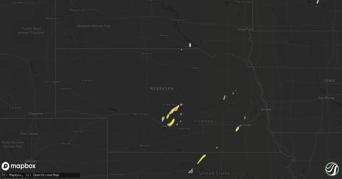
Hail Map in Nebraska on April 6, 2021
Get this storm
April 6 map
$229
one time, instant access
Download today. No call, no setup
Keep the $229
Bought the map and want the full workflow? Apply the entire $229 to a subscription within 7 days. None of it is wasted.
Every map, not just this one
This buys you this map. Subscription and you get every map we run, in the markets you choose from a few cities to whole states to nationwide. Plus real-time alerts the moment a storm fires.
Contact data
Name, contact info, occupancy, even credit band for addresses in the footprint. You go from where it hit to who to call.
Become the source they trust
Unlimited branding weather history reports on demand. You already have the documented answer ready for the property owner, and you are the one who showed up with it.
Property data and RoofTrace estimates
Pull up any address you have got, its value and the exact code rules for that jurisdiction, straight from One Click Code. Then RoofTrace estimates the squares, pitch, and roof value, priced the way you price.
Storm reports in Nebraska
Nebraska
| Date | Description |
|---|---|
| 04/06/20216:40 PM CDT | Hail ranged from pea to half dollar size... But mostly nickels and quarters |
| 04/06/20216:31 PM CDT | Corrects previous non-tstm wnd gst report changing from non-thunderstorm winds to thunderstrom wind gusts. Weatherlink mesonet eddyville 2 ssw. |
| 04/06/20212:29 AM CDT | At 728 PM CDT, a severe thunderstorm was located over Sumner, or 17 miles northeast of Lexington, moving northeast at 25 mph. HAZARD...60 mph wind gusts and half dollar size hail. SOURCE...Radar indicated. IMPACT...Hail damage to vehicles is expected. Expect wind damage to roofs, siding, and trees. Locations impacted include... Sumner, and rural areas of far northeastern Dawson and far northwestern Buffalo counties. |
| 04/06/20212:23 AM CDT | At 723 PM CDT, a severe thunderstorm was located over Ansley, or 15 miles southeast of Broken Bow, moving north at 20 mph. HAZARD...Golf ball size hail and 60 mph wind gusts. SOURCE...Trained weather spotters. IMPACT...People and animals outdoors will be injured. Expect hail damage to roofs, siding, windows, and vehicles. Expect wind damage to roofs, siding, and trees. Locations impacted include... Ansley, Mason City, Berwyn, Weissert, Westerville and Arcadia Diversion Dam State Wildlife Management Area.This includes the following highways... Highway 183 between mile markers 84 and 106. Highway 2 between mile markers 286 and 302. Highway 92 between mile markers 300 and 306. |
| 04/06/20212:21 AM CDT | At 720 AM CDT, a severe thunderstorm was located near Dorchester, or 21 miles southwest of Lincoln, moving northeast at 30 mph. HAZARD...60 mph wind gusts and quarter size hail. SOURCE...Radar indicated. IMPACT...Hail damage to vehicles is expected. Expect wind damage to roofs, siding, and trees. Locations impacted include... Crete, Milford, Dorchester, Pleasant Dale, Denton, Walnut Creek Recreation Area, Blue River State Recreation Area and Conestoga State Recreation Area.This includes Interstate 80 in Nebraska between mile markers 382 and390. |
| 04/06/20212:06 AM CDT | At 705 PM CDT, a severe thunderstorm was located 10 miles north of Kensington, or 21 miles northeast of Phillipsburg, moving northeast at 25 mph. HAZARD...60 mph wind gusts and quarter size hail. SOURCE...Radar indicated. IMPACT...Hail damage to vehicles is expected. Expect wind damage to roofs, siding, and trees. Locations impacted include... Franklin, Riverton and Inavale. |
| 04/06/20212:00 AM CDT | At 700 PM CDT, severe thunderstorms were located along a line extending from 8 miles north of Lexington to near Overton, moving northeast at 25 mph. HAZARD...60 mph wind gusts and quarter size hail. SOURCE...Radar indicated. IMPACT...Hail damage to vehicles is expected. Expect wind damage to roofs, siding, and trees. Locations impacted include... Sumner and Eddyville. |
| 04/06/20211:28 AM CDT | At 627 PM CDT, a severe thunderstorm was located just south of Oconto, or 20 miles north of Lexington, moving north at 40 mph. HAZARD...60 mph wind gusts and half dollar size hail. SOURCE...Radar indicated. IMPACT...Hail damage to vehicles is expected. Expect wind damage to roofs, siding, and trees. Locations impacted include... Oconto, Buckeye and Pressey State Wildlife Management Area. |
| 04/06/202112:59 AM CDT | At 558 PM CDT, a severe thunderstorm was located near Cozad, or 14 miles northwest of Lexington, moving northeast at 25 mph. HAZARD...60 mph wind gusts and half dollar size hail. SOURCE...Radar indicated. IMPACT...Hail damage to vehicles is expected. Expect wind damage to roofs, siding, and trees. This severe thunderstorm will remain over mainly rural areas of north central Dawson County, north-northeast of Cozad. |
| 04/05/20217:58 PM CDT | Strong winds along the cold front enhanced by the convection upstream. Estmated a swath of winds a half mile west to east with the northern edge near glenwood corners. |
| 04/05/20217:28 PM CDT | Via social media. |
| 04/05/20217:28 PM CDT | Fb report. |
| 04/05/20217:24 PM CDT | A local report indicates 1.75 inch wind near ANSLEY |
| 04/05/20217:15 PM CDT | Hail lasted for about 10 minutes and covered the ground. A few quarters mixed in. |
All States Impacted by Hail Map on April 6, 2021
Cities Impacted by Hail Map on April 6, 2021
- Amherst, NE
- Broken Bow, NE
- Ansley, NE
- Oconto, NE
- Minneapolis, MN
- Rush Center, KS
- Bison, KS
- La Crosse, KS
- Larned, KS
- Esbon, KS
- Burr Oak, KS
- Mankato, KS
- Brillion, WI
- Greenleaf, WI
- Lakewood, WI
- Seymour, WI
- Kaukauna, WI
- Appleton, WI
- Saint Francis, MN
- Isanti, MN
- Milford, NE
- Dorchester, NE
- Pawnee Rock, KS
- Rozel, KS
- Great Bend, KS
- Windom, KS
- Ruskin, NE
- Deshler, NE
- St John, KS
- Ellinwood, KS
- Bushton, KS
- Chase, KS
- Lyons, KS
- Valparaiso, NE
- Raymond, NE
- Arcadia, NE
- Black Creek, WI
- Lexington, NE
- Sumner, NE
- Overton, NE
- Stacy, MN
- North Branch, MN
- Pfeifer, KS
- Hays, KS
- Edgar, WI
- Colby, WI
- Clarkson, NE
- Eddyville, NE
- Reedsville, WI
- Crete, NE
- Pleasant Dale, NE
- Humphrey, NE
- Prairie Home, MO
- Jamestown, MO
- Leigh, NE
- Platte Center, NE
- Farmington, MN
- Rosemount, MN
- Vega, TX
- Paradise, KS
- Elk River, MN
- Anoka, MN
- Boonville, MO
- Wooldridge, MO
- Fairfax, SD
- Claflin, KS
- Raymond, KS
- Hereford, TX
- Sharon, KS
- Medicine Lodge, KS
- Bunceton, MO
- New Auburn, WI
- Inver Grove Heights, MN
- Marquette, KS
- Ellsworth, KS
- Weyerhaeuser, WI
- Geneseo, KS
- Hoisington, KS
- Little River, KS
- Saint Peter, MN
- Dayton, MN
- Pratt, KS
- Coats, KS
- Elm Creek, NE
- Sawyer, KS
- Mcpherson, KS
- Mason City, NE
- Osborne, KS
- Mondovi, WI
- Kasota, MN
- Le Sueur, MN
- Lindsborg, KS
- Prescott, WI
- River Falls, WI
- Forest Lake, MN
- Menasha, WI
- Spring Valley, WI
- Chetek, WI
- Victoria, KS
- Portis, KS
- Alton, KS
- Lorraine, KS
- Kinsley, KS
- Hastings, MN
- Antigo, WI
- Merrill, WI
- Gaylord, KS
- Cottage Grove, MN
- Osseo, MN
- White Lake, WI
- Bowler, WI
- California, MO
- Bethel, MN
- Cozad, NE
- Davey, NE
- Ceresco, NE
- Sun City, KS
- Attica, KS
- Maribel, WI
- Wildorado, TX
- Galva, KS
- Moundridge, KS
- Isabel, KS
- Hazelton, KS
- Mankato, MN
- Maple Grove, MN
- Bunker Hill, KS
- Lincoln, KS
- Beverly, KS
- Gorham, KS
- Wilson, KS
- Dorrance, KS
- Eau Claire, WI
- Dimmitt, TX
- Monroe, NE
- Sylvan Grove, KS
- Holyrood, KS
- Nekoma, KS
- Albert, KS
- Naper, NE
- Sterling, KS
- Harris, MN
- Tahlequah, OK
- Lebanon, KS


