Hail Map in Cumming, GA on April 6, 2016
The weather event in Cumming, GA on April 6, 2016 includes Hail map. 3 states and 63 cities were impacted and suffered possible damage. The total estimated number of properties impacted is 1,372.
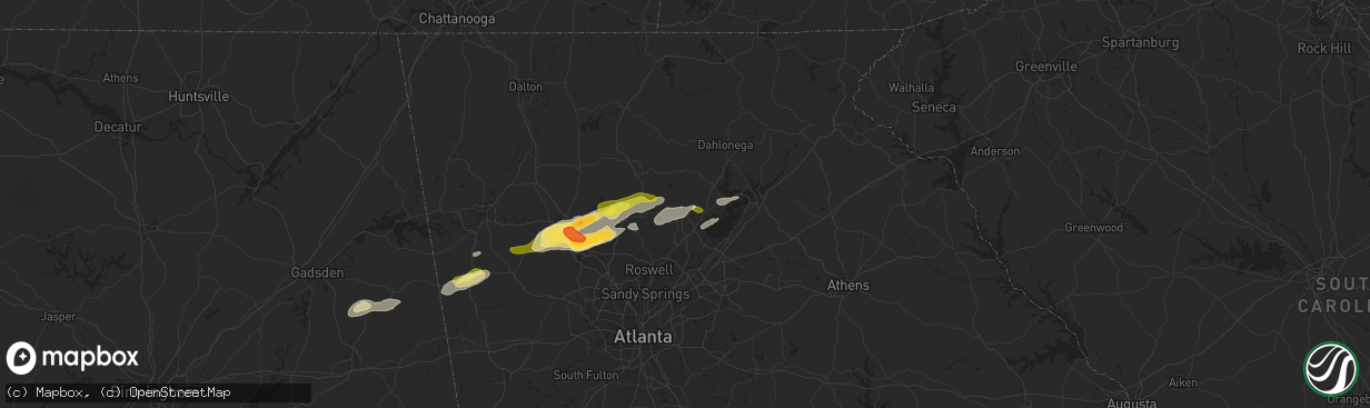
Hail
1,372
Estimated number of impacted properties by a 1.00" hail or larger0
Estimated number of impacted properties by a 1.75" hail or larger0
Estimated number of impacted properties by a 2.50" hail or largerStorm reports in Cumming, GA
Cumming, GA
| Date | Description |
|---|---|
| 04/05/201611:01 PM CDT | Social media report of hail on bramblett rd and pleasant grove road. |
| 04/05/201611:00 PM CDT | A large tree was blown onto sr-9 near spot rd. |
| 04/05/201610:10 PM CDT | A local report indicates 1.00 inch wind near 1 SE COAL MOUNTAIN |
All States Impacted by Hail Map on April 6, 2016
All Cities Impacted by Hail Map on April 6, 2016
- Ragland, AL
- Ohatchee, AL
- Columbus, GA
- Tallapoosa, GA
- Muscadine, AL
- Fruithurst, AL
- Buchanan, GA
- Acworth, GA
- Woodstock, GA
- Ashland, AL
- Emerson, GA
- Waleska, GA
- White, GA
- Ball Ground, GA
- Canton, GA
- Cartersville, GA
- Taylorsville, GA
- Fort Benning, GA
- Greenwood, MS
- Carrollton, MS
- Philipp, MS
- Charleston, MS
- Holcomb, MS
- Cascilla, MS
- Winona, MS
- McCarley, MS
- Alpharetta, GA
- Cumming, GA
- Cedartown, GA
- Rockmart, GA
- Seale, AL
- Dallas, GA
- Lowndesboro, AL
- Piedmont, AL
- Jacksonville, AL
- Sterrett, AL
- Orrville, AL
- Tyler, AL
- Sardis, AL
- Minter, AL
- Coffeeville, MS
- Water Valley, MS
- Faunsdale, AL
- Goodwater, AL
- Selma, AL
- Aragon, GA
- Tutwiler, MS
- Opelika, AL
- Phenix City, AL
- Big Creek, MS
- Bruce, MS
- Oakland, MS
- Hatchechubbee, AL
- Hurtsboro, AL
- Sylacauga, AL
- Weogufka, AL
- Gainesville, GA
- Marion Junction, AL
- Prattville, AL
- Lindale, GA
- Wellington, AL
- Hogansville, GA
- Calhoun City, MS


