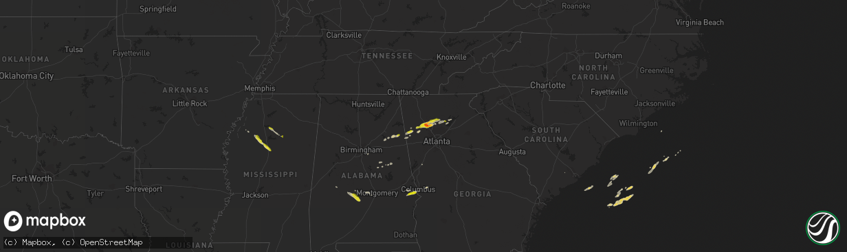
Hail Map on April 6, 2016
The weather event on April 6, 2016 includes Hail map. 3 states and 63 cities were impacted and suffered possible damage. The total estimated number of properties impacted is 27,759.
Hail
27,759
Estimated number of impacted properties by a 1.00" hail or larger445
Estimated number of impacted properties by a 1.75" hail or larger0
Estimated number of impacted properties by a 2.50" hail or largerStates Impacted by Hail Map on April 6, 2016
Storm reports
North Dakota
| Date | Description |
|---|---|
| 04/06/20165:52 PM CDT | A local report indicates 58 MPH wind near WASHBURN |
| 04/06/20165:37 PM CDT | A local report indicates 60 MPH wind near COLEHARBOR |
| 04/06/20165:19 PM CDT | A local report indicates 58 MPH wind near 1 W GARRISON |
Indiana
| Date | Description |
|---|---|
| 04/06/20164:15 PM CDT | Report from southeast side of city. Estiimated 60-65 mph. |
| 04/06/20164:15 PM CDT | Power line down on the northwest side of the city |
| 04/06/20164:12 PM CDT | Tree fell on powerline which caused a gas leak at a residence. Convective showers were in the area... But no thunderstorm. Time of occurrence is radar estimated. |
| 04/06/20163:55 PM CDT | Large limbs down. Via social media. |
Tennessee
| Date | Description |
|---|---|
| 04/06/20166:35 PM CDT | Numerous trees down all across clay county with several roads blocked |
| 04/06/20166:12 PM CDT | Tree down in carthage on jefferson ave. |
| 04/06/20166:04 PM CDT | Tree down on defeated creek rd. |
| 04/06/20165:23 PM CDT | A tree was blown down near the intersection of saundersville and nonaville roads. |
| 04/06/20165:23 PM CDT | Tree down across woods ferry rd in gallatin. |
| 04/06/20165:20 PM CDT | Tree and powerline down at 500 block of summit way |
| 04/06/20165:19 PM CDT | Trees were blown down in windtree trace. |
| 04/06/20165:18 PM CDT | Large tree limb in excess of one foot in diameter snapped and blocking lane of traffic on andrew jackson pkwy. |
| 04/06/20165:18 PM CDT | Tree down near indian lake elementary school in hendersonville. |
| 04/06/20165:17 PM CDT | Tree down on needmore rd near avalon bay. |
| 04/06/20165:16 PM CDT | Large tree down in green hills... Just southwest of downtown nashville. |
| 04/06/20165:15 PM CDT | Tree down across power lines in rayon city. |
| 04/06/20165:10 PM CDT | Wind shattered glass in revolving door at fifth third center. |
| 04/06/20165:05 PM CDT | Tree reportedly blown down onto rumours east restaurant in east nashville |
| 04/06/20165:05 PM CDT | Tree fell onto and destroyed a mobile home on dickerson pike |
| 04/06/20165:04 PM CDT | Large tree fell on car at 14th st and and davidson st. Time radar estimated. |
| 04/06/20165:00 PM CDT | Several trees were blown down in the temple hills to pasquo area. |
| 04/06/20164:50 PM CDT | Two large trees blown down at 1746 braxton bend drive... Just south of downtown fairview. |
| 04/06/20164:48 PM CDT | 69 mph wind gust measured and trees were blown down at highway 100 and s harpeth rd.. |
| 04/06/20164:39 PM CDT | Metal roof...lines...and trees down in the mount pleasant area. Time radar estimated. |
| 04/06/20164:37 PM CDT | Two large trees blown down at 1746 braxton bend drive... Just south of downtown fairview. |
| 04/06/20164:30 PM CDT | Trees were blown down along highway 48 n near garner creek and at mile marker 22. |
| 04/06/20162:56 PM CDT | Damaging winds resulted in damage to a roof and siding. A privacy fence was downed along with a few trees. |
Alabama
| Date | Description |
|---|---|
| 04/06/201611:55 AM CDT | Power outages with tree limbs donw reported. Pierce chapel road completely blocked by tops of trees. Time estimated. |
| 04/06/201612:25 AM CDT | Brief tor with winds of 70mph touched down along barbour creek rd snapping and uprooting numerous trees. |
| 04/06/201612:22 AM CDT | Tornado touched down in rural southern russell county just inside the county line. As it crossed farmland it flipped two irrigation pivots and destroyed a shed. The tor |
| 04/06/201612:16 AM CDT | A tornado touched down in rural barbour county west of clayton...north of the cr 9 and cr 44 intersection. It continued eastward for nearly 5.4 miles and snapped or upr |
| 04/06/201612:09 AM CDT | Large tree was uprooted near the intersection of sandfort rd and crosswinds rd causing damage to a mobile home. Several other mobile homes sustained minor damage. Max w |
| 04/05/201611:57 PM CDT | A 7.49 mile long 200 yard wide tor with winds of 90 mph touched down on stillwell rd and caused significant tree damage along richardson rd. Roof damage occurred along |
| 04/05/201611:55 PM CDT | Several trees reported down across alabama highway 51. Highway 51 at pierce chapel road blocked by large pine tree. Corrected time. |
| 04/05/201611:55 PM CDT | Power outages with tree limbs down reported. Pierce chapel road completely blocked by tops of trees. Time estimated. Corrected time. |
| 04/05/201611:54 PM CDT | A tornado touched down just west of bullock county rd 35 and traveled east for 7.74 miles before lifting just west of the barbour county line...with a maximum width of |
| 04/05/201611:44 PM CDT | A tornado touched down just north of lee rd 47/pierce chapel road causing minor damage to a garage roof and an enclosed porch and uprooting a large tree. It traveled ea |
| 04/05/201611:34 PM CDT | Several trees snapped and four trees uprooted near the greens apartment. Possible tornado. |
| 04/05/201611:32 PM CDT | A brief tornado touched down west of al hwy 29 on persimmon drive and moved east across the highway to an apartment complex. Several trees were uprooted along the path |
| 04/05/201611:24 PM CDT | A weak tornado touched down briefly near the mathews communty southwest of the intersection of us hwy 82 and old pike road...snapping a few trees along the .77 mile lon |
| 04/05/201611:18 PM CDT | A tornado touched down near the mitchell community near alabama hwy 110. Estimated peak winds of 75 mph were encountered along the 3 mile long 300 yard wide path...snap |
| 04/05/201611:03 PM CDT | Several trailer homes sustained damage from winds as well as a tree down on a trailer home off of pike road. |
| 04/05/201610:55 PM CDT | A 6 mile long 250 yard wide tornado with winds up to 80 mph touched down near the intersection of woodley and virginia loop roads. Numerous large trees snapped and upro |
| 04/05/201610:44 PM CDT | A local report indicates 1.00 inch wind near PHENIX CITY |
| 04/05/201610:28 PM CDT | Quarter size hail reported. |
| 04/05/201610:08 PM CDT | Large tree down along highway 48 near clay county line. |
| 04/05/201610:00 PM CDT | Power lines down along highway 9 halfway between ashland and lineville. |
| 04/05/201610:00 PM CDT | Tree down on highway 48 blocking road. |
| 04/05/201610:00 PM CDT | Tree down along highway 49 north at lineville city limit. |
| 04/05/201610:00 PM CDT | Trees and power lines down at talladega street and knowles avenue in lineville. |
| 04/05/20169:54 PM CDT | Trees down on bluff springs road and creek road. |
| 04/05/20169:25 PM CDT | Tree down on a storage building at hillcrest drive. |
| 04/05/20168:45 PM CDT | Tree uprooted along county road 54. |
| 04/05/20168:10 PM CDT | Second quarter size hail report in piedmont... Al |
| 04/05/20167:50 PM CDT | Quarter size hail reported in piedmont |
Georgia
| Date | Description |
|---|---|
| 04/06/20169:16 AM CDT | Hail fell at this location from 1015 to 1025 pm on april 6. The largest hailstone was one inch. |
| 04/06/20162:00 AM CDT | *** 2 inj *** trailer destroyed in dickey with 2 people seriously injured. |
| 04/06/20161:55 AM CDT | *** 4 inj *** 2 trailers at a trailer park just north of edison overturned with 3 to 4 minor injuries. |
| 04/06/20161:27 AM CDT | An ef-0 tornado tracked east-southeast across southern webster county. Damage was seen along path from ga-hwy 41...just northeast of the town of weston...to near the in |
| 04/06/201612:58 AM CDT | Providence canyon state park reported numerous trees down along a path several hundred yards long over the north side of the park. Damage lines up with radar-detected c |
| 04/06/201612:55 AM CDT | Providence canyon state park reported numerous trees down along a path several hundred yards long over the north side of the park. Damage lines up with radar-detected c |
| 04/06/201612:12 AM CDT | Several trees down in the flovilla community. Numerous power outages. |
| 04/05/201611:45 PM CDT | Several power lines down at corner of klondike road and smyrna road. |
| 04/05/201611:45 PM CDT | A couple of trees down in the brandy shaols area of northeast conyers along highway 20 south. |
| 04/05/201611:25 PM CDT | One tree down in senoia... Ga. |
| 04/05/201611:20 PM CDT | The hall county emergency manager reported 53 homes damaged west of oakwood. Nine homes received major damage and 5 were mostly destroyed. All of the damage was caused |
| 04/05/201611:07 PM CDT | A large tree was blown across memorial drive se near east lake park. |
| 04/05/201611:05 PM CDT | A large tree fell onto a home on westminster way ne causing extensive roof damage. |
| 04/05/201611:02 PM CDT | A tree fell onto power lines on windsor parkway near osbourne rd. |
| 04/05/201611:01 PM CDT | Social media report of hail on bramblett rd and pleasant grove road. |
| 04/05/201611:00 PM CDT | A large tree was blown onto sr-9 near spot rd. |
| 04/05/201610:55 PM CDT | A tree was downed on riverview rd near northside dr. |
| 04/05/201610:47 PM CDT | Large tree fell and landed on corner of apartment complex off favor rd nw just north of windy hill road. No injuries. |
| 04/05/201610:46 PM CDT | Large tree down on a home off country club road. Time estimated from radar. |
| 04/05/201610:44 PM CDT | 60 mph winds and nickel sized hail persisted for several minutes. |
| 04/05/201610:30 PM CDT | A large tree was reported down on a home. |
| 04/05/201610:29 PM CDT | Trees were blown down at hembredge drive and pinecrest rd. |
| 04/05/201610:23 PM CDT | Several trees reported downed in white |
| 04/05/201610:10 PM CDT | A local report indicates 1.00 inch wind near 1 SE COAL MOUNTAIN |
| 04/05/20169:36 PM CDT | Quarter sized hail near hobgood park |
| 04/05/20169:32 PM CDT | Quarter sized hail...strong winds. |
| 04/05/20169:16 PM CDT | A local report indicates 1.75 inch wind near RED TOP MOUNTAIN STATE |
| 04/05/20169:15 PM CDT | Hail fell at this location from 1015 to 1025 pm on april 6. The largest hailstone was one inch. |
| 04/05/20169:05 PM CDT | Report of 1 inch hail in emerson |
| 04/05/20169:05 PM CDT | Spotter reports of hail up to quarter size three miles northeast of cartersville at ga 20 and i-75. |
| 04/05/20168:59 PM CDT | Truck driver on i75 at exit 288 reported quarter sized hail with some as large as golf balls. |
| 04/05/20168:23 PM CDT | Dime to quarter sized hail just south of cedartown |
| 04/05/20168:22 PM CDT | Quarter sized hail in cedartown...covering the ground. Spotter says hail made dents in the car parked outside. |
Florida
| Date | Description |
|---|---|
| 04/06/20165:55 AM CDT | Clearwater public safety report of large tree uprooted in clearwater. |
| 04/06/20165:00 AM CDT | Fire dept report of large tree into home. Possible tornado damage. |
Kentucky
| Date | Description |
|---|---|
| 04/06/20166:55 PM CDT | Tree limbs reported down. |
| 04/06/20166:55 PM CDT | Downed tree on a power line resulting in 1000 customers without power |
| 04/06/20166:47 PM CDT | Few small tree limbs down. |
| 04/06/20166:27 PM CDT | Few small trees reported down. |
| 04/06/20166:18 PM CDT | Small tree limbs down. |
| 04/06/20166:01 PM CDT | A few small tree limbs down. |
Mississippi
| Date | Description |
|---|---|
| 04/06/20166:50 PM CDT | Dime to quarter size hail fell in the jefferson community. |
| 04/06/20166:40 PM CDT | Picture of quarter sized hail relayed via twitter picture |
| 04/06/20166:35 PM CDT | Nickel to quarter size hail fell in holcomb. Relayed via social media. |
| 04/05/20167:20 PM CDT | Fell a few miles north of winona. Report relayed via broadcast media. |
| 04/05/20167:16 PM CDT | Quarter sized hail reported in calhoun city |
South Carolina
| Date | Description |
|---|---|
| 04/06/20165:32 AM CDT | Power lines down on patty road |
| 04/06/20165:12 AM CDT | Warning point reported large maple tree down in windsor court. |
| 04/06/20162:45 AM CDT | Rcwinds mesonet recorded a wind gust of 61 mph at their ballentine site. |
| 04/06/20162:40 AM CDT | A wind gust of 64 mph was recorded at flotilla island. |
| 04/06/20162:30 AM CDT | Public report of several trees down in chapin |
| 04/06/20162:09 AM CDT | Tree down along old golf course road. |
| 04/06/20162:06 AM CDT | Tree down at mt. Willing road and high point road. |
| 04/06/20162:05 AM CDT | Large tree down across highway 378 five miles east of saluda. |
| 04/06/20162:03 AM CDT | Tree down along emory road near forrest hills road. |
| 04/06/20162:00 AM CDT | Several trees down along forrest hills road near the intersection of ridge spring highway. |
Illinois
| Date | Description |
|---|---|
| 04/06/20164:15 PM CDT | Report from southeast side of city. Estiimated 60-65 mph. |
| 04/06/20163:34 PM CDT | Power lines down in ridgway |
| 04/06/20163:30 PM CDT | Numerous power poles down on granger and robinson streets in harrisburg. |
Cities Impacted by Hail Map on April 6, 2016
- Ragland, AL
- Ohatchee, AL
- Columbus, GA
- Tallapoosa, GA
- Muscadine, AL
- Fruithurst, AL
- Buchanan, GA
- Acworth, GA
- Woodstock, GA
- Ashland, AL
- Emerson, GA
- Waleska, GA
- White, GA
- Ball Ground, GA
- Canton, GA
- Cartersville, GA
- Taylorsville, GA
- Fort Benning, GA
- Greenwood, MS
- Carrollton, MS
- Philipp, MS
- Charleston, MS
- Holcomb, MS
- Cascilla, MS
- Winona, MS
- McCarley, MS
- Alpharetta, GA
- Cumming, GA
- Cedartown, GA
- Rockmart, GA
- Seale, AL
- Dallas, GA
- Lowndesboro, AL
- Piedmont, AL
- Jacksonville, AL
- Sterrett, AL
- Orrville, AL
- Tyler, AL
- Sardis, AL
- Minter, AL
- Coffeeville, MS
- Water Valley, MS
- Faunsdale, AL
- Goodwater, AL
- Selma, AL
- Aragon, GA
- Tutwiler, MS
- Opelika, AL
- Phenix City, AL
- Big Creek, MS
- Bruce, MS
- Oakland, MS
- Hatchechubbee, AL
- Hurtsboro, AL
- Sylacauga, AL
- Weogufka, AL
- Gainesville, GA
- Marion Junction, AL
- Prattville, AL
- Lindale, GA
- Wellington, AL
- Hogansville, GA
- Calhoun City, MS