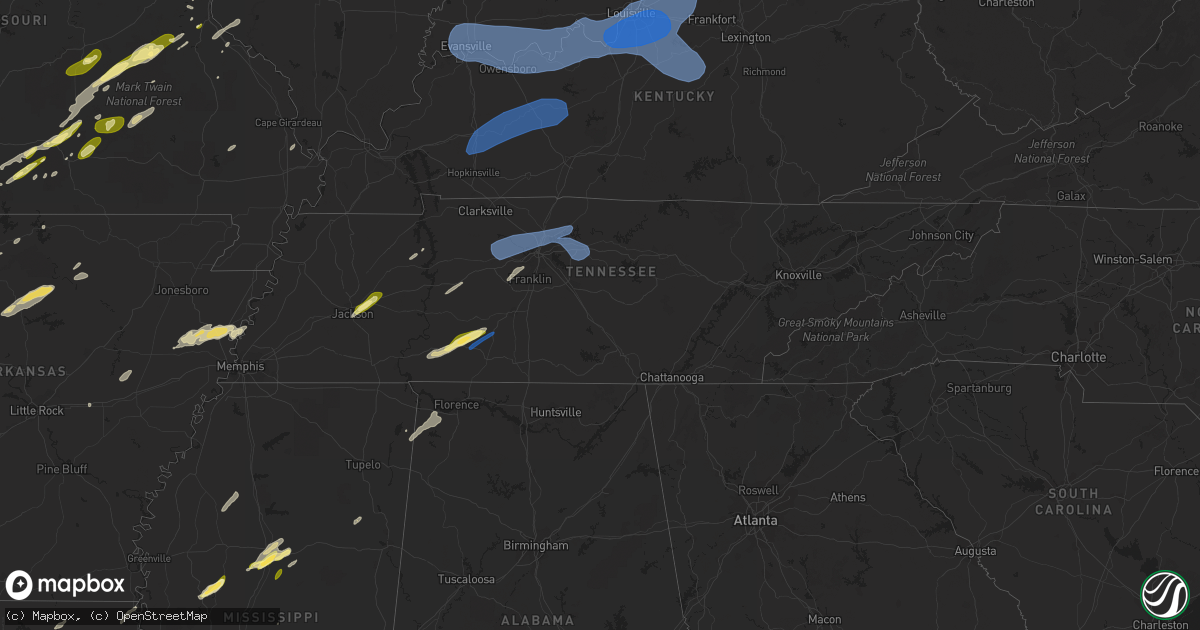
Hail Map in Tennessee on April 5, 2023
Get this storm
April 5 map
$229
one time, instant access
Download today. No call, no setup
Keep the $229
Bought the map and want the full workflow? Apply the entire $229 to a subscription within 7 days. None of it is wasted.
Every map, not just this one
This buys you this map. Subscription and you get every map we run, in the markets you choose from a few cities to whole states to nationwide. Plus real-time alerts the moment a storm fires.
Contact data
Name, contact info, occupancy, even credit band for addresses in the footprint. You go from where it hit to who to call.
Become the source they trust
Unlimited branding weather history reports on demand. You already have the documented answer ready for the property owner, and you are the one who showed up with it.
Property data and RoofTrace estimates
Pull up any address you have got, its value and the exact code rules for that jurisdiction, straight from One Click Code. Then RoofTrace estimates the squares, pitch, and roof value, priced the way you price.
Storm reports in Tennessee
Tennessee
| Date | Description |
|---|---|
| 04/05/20234:31 PM CDT | Public weather station northeast of mount juliet. |
| 04/05/20234:15 PM CDT | Reports of roof blown off house and several trees down in summertown along sweet gum lane. |
| 04/05/20234:15 PM CDT | Reports received of roof damage and uprooted trees from severe thunderstorm winds along north old military road in summertown. |
| 04/05/20234:11 PM CDT | Four inch diameter cherry tree downed along tennessee route 240. |
| 04/05/20234:07 PM CDT | Tree downed near cleveland park in north nashville. Report courtesy of tspotter. |
| 04/05/20234:05 PM CDT | Awos station kjwn nashville john tune airport. |
| 04/05/20234:03 PM CDT | School bus driver reported estimated quarter size hail along brush creek road. |
| 04/05/20234:02 PM CDT | Tree snapped along little marrowbone road near beaman park. Report and photo courtesy of tspotter. |
| 04/05/20233:18 PM CDT | Tree downed and blocking the highway along i-40 at mile marker 163. Time estimated based on radar. |
| 04/05/20232:37 PM CDT | Tree down approximately 3 to 5 miles from 77... And powerlines down across reynoldsburg rd. And highway 77. |
| 04/05/20232:25 PM CDT | Damage to metal outbuilding in the blue goose community. |
| 04/05/20232:15 PM CDT | Penny sized hail reported. |
| 04/05/20231:40 PM CDT | Power poles and power lines down on houston levee. |
| 04/05/20231:30 PM CDT | Large tree down across wilkinsville road between west union and walker. |
| 04/05/20231:29 PM CDT | Power poles and powerlines down on riverdale road. |
All States Impacted by Hail Map on April 5, 2023
Cities Impacted by Hail Map on April 5, 2023
- Greenwood, AR
- Huntington, AR
- Hackett, AR
- Drury, MO
- Mountain Grove, MO
- Vanzant, MO
- Wasola, MO
- Ava, MO
- Squires, MO
- Norwood, MO
- Cabool, MO
- Elk Creek, MO
- Solo, MO
- Salem, MO
- Cook Sta, MO
- Cherryville, MO
- Martinsville, IN
- Mooresville, IN
- Brooklyn, IN
- West Newton, IN
- Camby, IN
- Indianapolis, IN
- Saint Louis, MO
- Fenton, MO
- Arnold, MO
- House Springs, MO
- Imperial, MO
- High Ridge, MO
- Cedar Hill, MO
- Barnhart, MO
- Hillsboro, MO
- East Carondelet, IL
- Columbia, IL
- Davisville, MO
- Steelville, MO
- Potosi, MO
- Bourbon, MO
- Cadet, MO
- Richwoods, MO
- Houston, MO
- Yukon, MO
- Eunice, MO
- Raymondville, MO
- Mountain View, MO
- Willow Springs, MO
- Summersville, MO
- Eminence, MO
- Hartshorn, MO
- Crawfordsville, IN
- Ladoga, IN
- New Ross, IN
- Jamestown, IN
- Lebanon, IN
- Whitestown, IN
- Zionsville, IN
- Clinton, AR
- De Soto, MO
- Alma, AR
- Red Bud, IL
- Blackwell, MO
- Ullin, IL
- Bixby, MO
- Mineral Point, MO
- Deer, AR
- Copenhagen, NY
- Lowville, NY
- Sainte Genevieve, MO
- Olive Branch, IL
- Tamms, IL
- Miller City, IL
- Thebes, IL
- Hodgen, OK
- Rolla, MO
- Charleston, AR
- Everton, AR
- Saint Joe, AR
- Jerusalem, AR
- Hector, AR
- Noble, MO
- Dora, MO
- Ozark, AR
- Cecil, AR
- Belleville, NY
- Henderson, NY
- Melbourne, AR
- Sage, AR
- Cotton Plant, AR
- Des Arc, AR
- Paris, AR
- Magazine, AR
- Cameron, OK
- Farmington, MO
- Benton, MO
- Bloomsdale, MO
- Festus, MO
- Bradleyville, MO
- Oldfield, MO
- Mount Pleasant, AR
- Batesville, AR
- Fort Smith, AR
- Yellville, AR
- Lamar, AR
- Ozone, AR
- Clarksville, AR
- Hagarville, AR
- Altus, AR
- Hartman, AR
- New Blaine, AR
- Delaware, AR
- Subiaco, AR
- Ratcliff, AR
- Cherry Valley, AR
- Parkin, AR
- Marlin, TX
- Reagan, TX
- Leslie, AR
- Shirley, AR
- Fox, AR
- Mountain View, AR
- Harrison, AR
- Whitesboro, OK
- Taneyville, MO
- Mulberry, AR
- Dennard, AR
- Russellville, AR
- Dover, AR
- San Pierre, IN
- North Judson, IN
- Booneville, AR
- Grand Cane, LA
- Shreveport, LA
- Frierson, LA
- Prairie Du Rocher, IL
- Fults, IL
- Hazen, AR
- Carlisle, AR
- Scranton, AR
- Wynne, AR
- Marked Tree, AR
- Earle, AR
- Eustace, TX
- Zalma, MO
- McGee, MO
- Mena, AR
- Heavener, OK
- Ellington, MO
- Centerville, MO
- Branch, AR
- Henderson, AR
- Oark, AR
- Saint Johns, MI
- Elsie, MI
- Ovid, MI
- Oakley, MI
- Henderson, MI
- Dyer, AR
- Waldron, AR
- Poteau, OK
- Mansfield, AR
- Hartford, AR
- Coal Hill, AR
- Thornfield, MO
- Theodosia, MO
- Gassville, AR
- Mountain Home, AR
- Flippin, AR
- Rodman, NY
- Adams, NY
- Lorraine, NY
- Mannsville, NY
- Adams Center, NY
- Watertown, NY
- Nashville, AR
- Scotland, AR
- Licking, MO
- Hearne, TX
- Bryan, TX
- Lott, TX
- Mountainburg, AR
- Valley Springs, AR
- Elm Grove, LA
- Liberty Center, IN
- Bluffton, IN
- Decatur, IN
- Jackson, TN
- Beech Bluff, TN
- Lexington, TN
- Cedar Grove, TN
- Georgetown, LA
- Dry Prong, LA
- Winnfield, LA
- Atlanta, LA
- Tullos, LA
- Olla, LA
- Sikes, LA
- Grayson, LA
- Evansville, IN
- Haubstadt, IN
- Wadesville, IN
- Poseyville, IN
- Mount Vernon, IN
- Henderson, KY
- Spottsville, KY
- Newburgh, IN
- Reed, KY
- Evanston, IN
- Boonville, IN
- Richland, IN
- Tennyson, IN
- Elberfeld, IN
- Gentryville, IN
- Chandler, IN
- Chrisney, IN
- Grandview, IN
- Lamar, IN
- Owensboro, KY
- Rockport, IN
- Troy, IN
- Lynnville, IN
- Maceo, KY
- Lewisport, KY
- Philpot, KY
- Hawesville, KY
- Whitesville, KY
- Reynolds Station, KY
- Saint Meinrad, IN
- Santa Claus, IN
- Tell City, IN
- Dale, IN
- Lincoln City, IN
- Yazoo City, MS
- Silver City, MS
- Tchula, MS
- Belzoni, MS
- Hardinsburg, KY
- Rome, IN
- Derby, IN
- Cannelton, IN
- Cloverport, KY
- Battletown, KY
- Leopold, IN
- Union Star, KY
- Stephensport, KY
- Payneville, KY
- Branchville, IN
- Coila, MS
- West, MS
- Vaiden, MS
- Irvington, KY
- Rhodelia, KY
- Harned, KY
- Webster, KY
- Guston, KY
- Corydon, IN
- Mauckport, IN
- Brandenburg, KY
- Central, IN
- Leavenworth, IN
- Graham, KY
- Greenville, KY
- Belton, KY
- Hopkinsville, KY
- Beech Creek, KY
- Bremen, KY
- Centertown, KY
- Beechmont, KY
- Madisonville, KY
- Browder, KY
- Crofton, KY
- Powderly, KY
- Central City, KY
- White Plains, KY
- Nortonville, KY
- Drakesboro, KY
- Rochester, KY
- Beaver Dam, KY
- Cromwell, KY
- Horse Branch, KY
- Morgantown, KY
- Hartford, KY
- Rockport, KY
- Olaton, KY
- McHenry, KY
- Rosine, KY
- Caneyville, KY
- Cruger, MS
- Laconia, IN
- Ekron, KY
- Vine Grove, KY
- Winona, MS
- Waynesboro, TN
- Kilmichael, MS
- Lawrenceburg, TN
- Hohenwald, TN
- West Point, KY
- Fort Knox, KY
- Muldraugh, KY
- Elizabeth, IN
- Louisville, KY
- Lanesville, IN
- New Middletown, IN
- Shepherdsville, KY
- Clarksville, IN
- Brooks, KY
- New Albany, IN
- Jeffersonville, IN
- Masonic Home, KY
- Fairdale, KY
- Mount Washington, KY
- Fisherville, KY
- Finchville, KY
- Taylorsville, KY
- Coxs Creek, KY
- Simpsonville, KY
- Shelbyville, KY
- Clermont, KY
- Lebanon Junction, KY
- La Grange, KY
- Pewee Valley, KY
- Smithfield, KY
- Buckner, KY
- Crestwood, KY
- Glenview, KY
- Prospect, KY
- Summertown, TN
- Mount Eden, KY
- Waddy, KY
- Terry, MS
- Raymond, MS
- Byram, MS
- Dickson, TN
- White Bluff, TN
- Charlotte, TN
- Ashland City, TN
- Pegram, TN
- Kingston Springs, TN
- Joelton, TN
- Nashville, TN
- Stewart, MS
- Ethel, MS
- Whites Creek, TN
- Goodlettsville, TN
- Hendersonville, TN
- Lebanon, TN
- Old Hickory, TN
- Madison, TN
- Mount Juliet, TN
- Gallatin, TN
- Jackson, MS
- Pendleton, KY
- Bagdad, KY
- Eminence, KY
- Sulphur, KY
- Campbellsburg, KY
- Pleasureville, KY
- New Castle, KY
- Ethridge, TN
- Mount Pleasant, TN
- Bethlehem, KY
- Turners Station, KY
- Keuka Park, NY
- Penn Yan, NY
- Watertown, TN
- Clinton, MS
- Bolton, MS
- Boston, KY
- Springfield, KY
- Willisburg, KY
- Saint Catharine, KY
- Fairfield, KY
- Bloomfield, KY
- Bardstown, KY
- Brandon, MS
- Flowood, MS
- Mackville, KY
- Chaplin, KY
- Lawrenceburg, KY
- Harrodsburg, KY
- Salvisa, KY
- Perryville, KY
- Kennard, TX
- Crockett, TX
- Grapeland, TX
- Wells, TX
- Alto, TX
- Farmerville, LA
- Red Bay, AL
- Golden, MS
- Belmont, MS
- Franklin, TN
- Fairview, TN
- Collinwood, TN
- Olivehill, TN
- Lutts, TN
- Centerville, TN
- Lobelville, TN
- Only, TN
- Camden, TN
- Joiner, AR
- Drummonds, TN
- Bassett, AR
- Tyronza, AR
- Frenchmans Bayou, AR
- Gilmore, AR
- Turrell, AR
- Duck Hill, MS
- French Camp, MS
- Call, TX
- Bon Wier, TX
- Kirbyville, TX
- Leesville, LA
- Mora, LA
- Dennis, MS
- Sondheimer, LA
- Lake Providence, LA
- Jonesville, LA
- Bastrop, LA
- Buna, TX
- Canton, MS
- Big Sandy, TN
- Tallulah, LA
- Colfax, LA
- Prairie, MS
- Aberdeen, MS
- Cherokee, AL
- West Point, MS
- Cascilla, MS
- Charleston, MS
- Millington, TN
- Cushing, TX
- Rusk, TX
- Richmond, TX
- Katy, TX
- Houston, TX
- Cypress, TX
- Victoria, TX
- Inez, TX
- Edna, TX
- Bellville, TX
- Sealy, TX
- Huntsville, TX
- Trinity, TX
- Chappell Hill, TX
- New Waverly, TX
- Willis, TX
- Groveton, TX
- Guerra, TX
- Hebbronville, TX
- Garwood, TX
- Eagle Lake, TX
- Alleyton, TX
- De Berry, TX
- Waskom, TX
- Greenwood, LA
- Livingston, TX
- Cat Spring, TX
- Woodville, TX
- Calliham, TX
- Jourdanton, TX
- Laredo, TX
- Freer, TX
- Tilden, TX
- Encinal, TX
- Cuero, TX
- Yoakum, TX
- Campbellton, TX
- Hallettsville, TX
- Shiner, TX
- New Ulm, TX
- Anderson, AL
- Rogersville, AL
- Beasley, TX
- Needville, TX
- Rosenberg, TX
- Mabank, TX
- Colmesneil, TX
- Chester, TX
- Henderson, TX
- Laneville, TX
- Carthage, MS
- Hemphill, TX
- Pineland, TX
- Bronson, TX
- Lovelady, TX
- Newellton, LA
- Rueter, MO
- Kissee Mills, MO
- Cedarcreek, MO
- Pearl, MS
- Florence, MS
- Reklaw, TX
- Jacksonville, TX
- Junction City, AR
- Russellville, AL
- Mount Enterprise, TX
- Gibsland, LA
- Dubberly, LA
- Longview, TX
- Kilgore, TX
- Warren, TX
- Sugar Land, TX
- Haynesville, LA
- Haughton, LA
- Minden, LA
- Shongaloo, LA
- Cotton Valley, LA
- Long Branch, TX
- Carthage, TX
- Bethany, LA
- Richland, MS
- Harrisonburg, LA
- Tuscumbia, AL
- Sterlington, LA
- El Dorado, AR
- Tatum, TX
- Hallsville, TX
- Schulenburg, TX
- Ridgeland, MS
- Madison, MS
- Tougaloo, MS
- Douglass, TX
- Moulton, AL
- Brookshire, TX
- Heflin, LA
- Shepherd, TX
- Coldspring, TX
- Cleveland, TX
- Falls City, TX
- Karnes City, TX
- Seguin, TX
- Kingsbury, TX
- San Marcos, TX
- Martindale, TX
- Pleasanton, TX
- Floresville, TX
- Muldrow, OK
- Roland, OK
- Rudy, AR
- Van Buren, AR
- Maxwell, TX
- Lockhart, TX
- La Vernia, TX
- Branson, MO
- Rockaway Beach, MO
- Forsyth, MO
- Sedalia, MO
- Hughesville, MO
- Nelson, MO
- La Monte, MO
- Pilot Grove, MO
- Falls City, NE
- Hiawatha, KS
- Lewistown, MO
- La Belle, MO
- Burlington Junction, MO
- Clearmont, MO
- Fremont, MO
- Alton, MO
- Ellsinore, MO
- Doniphan, MO
- Van Buren, MO
- Grandin, MO
- Mill Spring, MO
- Neosho, MO
- Goodman, MO
- Higbee, MO
- Fayette, MO
- Madison, MO
- Moberly, MO
- Clark, MO
- Anabel, MO
- Clarence, MO
- Riverton, KS
- Webb City, MO
- Galena, KS
- Joplin, MO
- Oronogo, MO
- Columbus, KS
- Carl Junction, MO
- Baxter Springs, KS
- Forest City, MO
- Mound City, MO
- Maitland, MO
- Fillmore, MO
- Oregon, MO
- Maryville, MO
- Hopkins, MO
- Pickering, MO
- Bedford, IA
- Graham, MO
- Barnard, MO
- Skidmore, MO
- Appleton City, MO
- Butler, MO
- Clinton, MO
- Osceola, MO
- Montrose, MO
- Greenfield, MO
- Dadeville, MO
- Fair Play, MO
- Aldrich, MO
- Lockwood, MO
- Half Way, MO
- Buffalo, MO
- Bolivar, MO
- Louisburg, MO
- Polk, MO
- Everton, MO
- Dunnegan, MO
- Canton, MO
- Warsaw, IL
- Rayville, MO
- Liberty, MO
- Excelsior Springs, MO
- Lawson, MO
- Kansas City, KS
- Kansas City, MO
- Kearney, MO
- Sturgeon, MO
- Rocheport, MO
- Franklin, MO
- New Franklin, MO
- Centralia, MO
- Columbia, MO
- Harrisburg, MO
- Mexico, MO
- Santa Fe, MO
- Boonville, MO
- Thompson, MO
- Monticello, MO
- Ewing, MO
- La Grange, MO
- Leavenworth, KS
- Weston, MO
- Platte City, MO
- Fort Leavenworth, KS
- Dearborn, MO
- Carthage, MO
- Reeds, MO
- Ursa, IL
- Shelbyville, MO
- Mendon, IL
- Loraine, IL
- Macon, MO
- Basco, IL
- West Point, IL
- Sutter, IL
- Newark, MO
- Excello, MO
- Leonard, MO
- Carthage, IL
- Bethel, MO
- Jacksonville, MO
- Nevada, MO
- Rockville, MO
- Harwood, MO
- Walker, MO
- Schell City, MO
- Middletown, MO
- Auxvasse, MO
- Vandalia, MO
- Ashland, MO
- Wellsville, MO
- Kingdom City, MO
- Fulton, MO
- Martinsburg, MO
- Leeton, MO
- Paris, MO
- Marshall, MO
- Perry, MO
- Warrensburg, MO
- Urich, MO
- Stoutsville, MO
- Chilhowee, MO
- Knob Noster, MO
- Blairstown, MO
- Windsor, MO
- Houstonia, MO
- Green Ridge, MO
- Blackwater, MO
- Knox City, MO
- Williamsville, MO
- Greenville, MO
- Piedmont, MO
- Eagle Rock, MO
- Cassville, MO
- Golden, MO
- Eureka Springs, AR
- Shell Knob, MO
- Deepwater, MO
- Rich Hill, MO
- Craig, MO
- Calhoun, MO
- Milo, MO
- Sheldon, MO
- El Dorado Springs, MO
- Lamar, MO
- Russellville, MO
- Centertown, MO
- Jefferson City, MO
- Holts Summit, MO
- New Bloomfield, MO
- Hartsburg, MO
- Lohman, MO
- Flemington, MO
- Stockton, MO
- Arcola, MO
- Humansville, MO
- Highland, KS
- Robinson, KS
- Bolckow, MO
- Troy, KS
- Newburg, MO
- Saint James, MO
- Edgar Springs, MO
- Kyle, TX
- Leesville, TX
- Gonzales, TX
- Waelder, TX
- Luling, TX
- Flatonia, TX
- Dale, TX
- Del Valle, TX
- Cedar Creek, TX
- Cotulla, TX
- Concepcion, TX
- Realitos, TX
- San Ygnacio, TX
- Weimar, TX
- Rosanky, TX
- Harwood, TX
- Giddings, TX
- Zapata, TX
- Robstown, TX
- Hempstead, TX
- Milam, TX
- Oakhurst, TX
- Lincoln, TX
- El Campo, TX
- Smithville, TX
- Bedias, TX
- Richards, TX
- Pearsall, TX
- Premont, TX
- Overton, TX
- Whitsett, TX
- Utica, MS
- Crystal Springs, MS
- Odem, TX
- Mathis, TX
- Encino, TX
- Louise, MS
- Camden, MS
- Delhi, LA
- Adkins, TX
- San Diego, TX
- New Braunfels, TX
- Christine, TX
- Plainfield, IN
- Monrovia, IN
- Paragon, IN
- Quincy, IN
- Cloverdale, IN
- Spencer, IN
- Gosport, IN
- Ellettsville, IN
- Poland, IN
- Freedom, IN
- Coal City, IN
- Bowling Green, IN
- Bloomfield, IN
- Worthington, IN
- Clay City, IN
- Jasonville, IN
- Switz City, IN
- Mccordsville, IN
- Greenfield, IN


