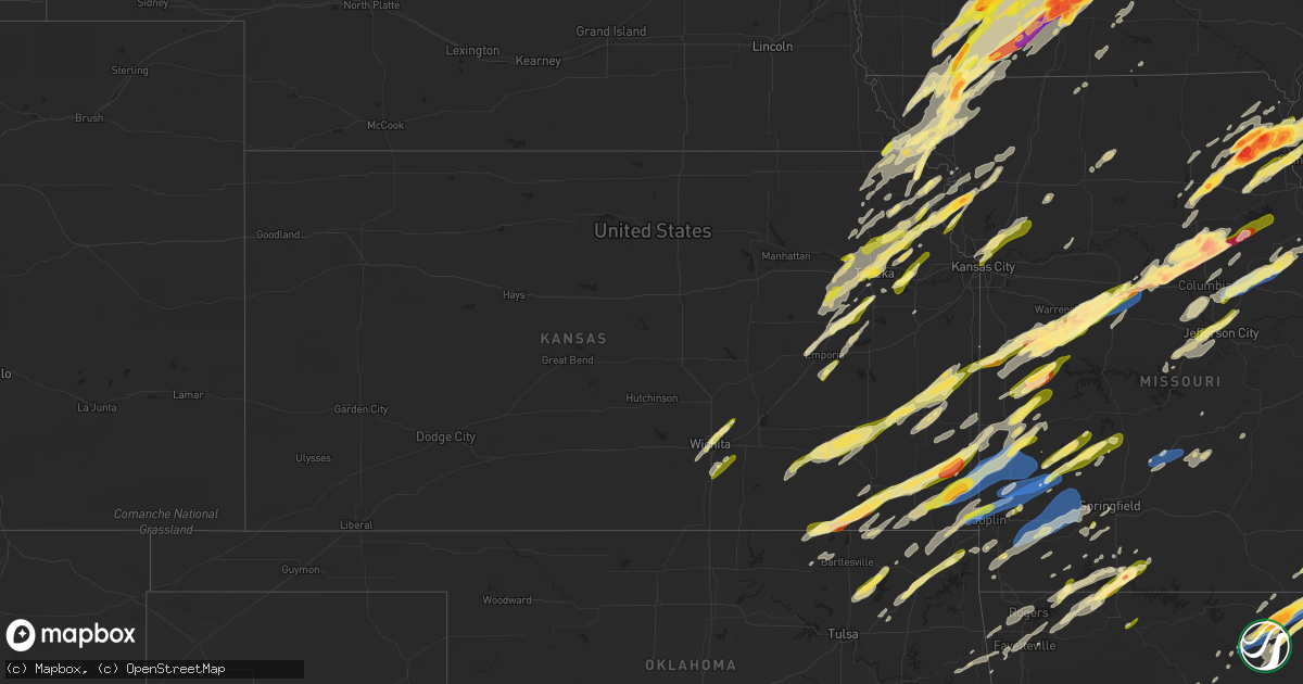
Hail Map in Kansas on April 4, 2023
Get this storm
April 4 map
$229
one time, instant access
Download today. No call, no setup
Keep the $229
Bought the map and want the full workflow? Apply the entire $229 to a subscription within 7 days. None of it is wasted.
Every map, not just this one
This buys you this map. Subscription and you get every map we run, in the markets you choose from a few cities to whole states to nationwide. Plus real-time alerts the moment a storm fires.
Contact data
Name, contact info, occupancy, even credit band for addresses in the footprint. You go from where it hit to who to call.
Become the source they trust
Unlimited branding weather history reports on demand. You already have the documented answer ready for the property owner, and you are the one who showed up with it.
Property data and RoofTrace estimates
Pull up any address you have got, its value and the exact code rules for that jurisdiction, straight from One Click Code. Then RoofTrace estimates the squares, pitch, and roof value, priced the way you price.
Storm reports in Kansas
Kansas
| Date | Description |
|---|---|
| 04/04/20236:11 PM CDT | A local report indicates 1.25 inch wind near HIGHLAND |
| 04/04/20233:13 AM CDT | Photo with estimated quarter size hail. |
| 04/04/20233:13 AM CDT | Report from mping: quarter |
| 04/04/20233:08 AM CDT | Half dollar sized hail reported by public. Relayed by media. |
| 04/04/20232:55 AM CDT | A local report indicates 1.00 inch wind near OSWEGO |
| 04/04/20232:54 AM CDT | Relayed by broadcast media. |
| 04/04/20232:15 AM CDT | Location and time approximate. Emergency management reported wind damage to roofs south of fort scott. |
| 04/04/20231:45 AM CDT | Location and time approximate. Numerous incidents of substantial wind damage across mainly the northern half of bourbon county. Barns destroyed...roofs off homes and bu |
| 04/04/20231:44 AM CDT | Report from mping: half dollar |
| 04/04/202312:45 AM CDT | Delayed report. Tree down just north of town. |
| 04/04/202312:45 AM CDT | Corrects previous tstm wnd dmg report from 2 n redfield. Location and time approximate. Numerous incidents of substantial wind damage across mainly the northern half of |
| 04/04/202312:30 AM CDT | Ks mesonet site reported a gust to 79 mph. |
| 04/04/202312:20 AM CDT | A local report indicates 1.25 inch wind near IOLA |
| 04/04/202312:20 AM CDT | Tree damage in iola. |
| 04/04/202312:15 AM CDT | Report that an apartment complex lost its garages due to strong winds. Report was passed on from allen county dispatch. |
| 04/04/202312:06 AM CDT | Delayed report with pictures showing several large trees uprooted with roof damage to numerous buildings. Winds estimated in the 80-90 mph range. |
| 04/04/202312:05 AM CDT | Getting reports of considerable tree damage across chanute along with roof damage to numerous buildings. |
| 04/04/202312:04 AM CDT | A local report indicates 70 MPH wind near 1 W CHANUTE |
| 04/03/202311:52 PM CDT | A local report indicates 1.00 inch wind near 2 E TORONTO |
| 04/03/202311:49 PM CDT | A local report indicates 1.00 inch wind near 2 E COYVILLE |
| 04/03/202311:45 PM CDT | Delayed report about tree and house damage. |
| 04/03/202311:30 PM CDT | A local report indicates 1.00 inch wind near 1 NNW SEVERY |
| 04/03/202310:39 PM CDT | Social media. |
| 04/03/202310:35 PM CDT | Cwop weather station. |
| 04/03/202310:25 PM CDT | Cracked windshield of car. |
| 04/03/20239:49 PM CDT | Report from mping: quarter |
| 04/03/20239:13 PM CDT | A local report indicates 1.00 inch wind near ATCHISON |
| 04/03/20239:09 PM CDT | Lakeside village boat ramp. |
| 04/03/20238:57 PM CDT | A local report indicates 1.00 inch wind near 3 ENE TOPEKA |
| 04/03/20238:56 PM CDT | Relayed via nws wichita. |
| 04/03/20238:38 PM CDT | A local report indicates 1.00 inch wind near 7 SSE SILVER LAKE |
| 04/03/20238:35 PM CDT | A local report indicates 1.00 inch wind near 3 N EFFINGHAM |
| 04/03/20238:03 PM CDT | Report from mping: quarter |
| 04/03/20238:03 PM CDT | A local report indicates 1.00 inch wind near ESKRIDGE |
| 04/03/20238:00 PM CDT | A local report indicates 1.00 inch wind near WILLARD |
| 04/03/20237:33 PM CDT | A local report indicates 60 MPH wind near HAMLIN |
All States Impacted by Hail Map on April 4, 2023
Cities Impacted by Hail Map on April 4, 2023
- Williamsburg, IA
- Homestead, IA
- South Amana, IA
- Marengo, IA
- Conesville, IA
- Columbus Junction, IA
- Lone Tree, IA
- Nichols, IA
- Fairfax, IA
- Cedar Rapids, IA
- Marion, IA
- Springville, IA
- Letts, IA
- Muscatine, IA
- Atalissa, IA
- Moscow, IA
- Wilton, IA
- West Liberty, IA
- Stockton, IA
- Blue Grass, IA
- Durant, IA
- Davenport, IA
- Walcott, IA
- Eldridge, IA
- Bettendorf, IA
- Le Claire, IA
- Dixon, IA
- Long Grove, IA
- Donahue, IA
- Princeton, IA
- Port Byron, IL
- Hillsdale, IL
- Geneseo, IL
- Erie, IL
- Prophetstown, IL
- Taylor Ridge, IL
- Andalusia, IL
- Buffalo, IA
- Milan, IL
- Rock Island, IL
- Fulton, IL
- Fenton, IL
- Morrison, IL
- Albany, IL
- Coal Valley, IL
- Moline, IL
- Sterling, IL
- East Moline, IL
- Silvis, IL
- Clinton, IA
- Thomson, IL
- Mount Carroll, IL
- Savanna, IL
- Chadwick, IL
- Colona, IL
- Milledgeville, IL
- Polo, IL
- Lanark, IL
- Atkinson, IL
- Dixon, IL
- Woosung, IL
- Oregon, IL
- Ashton, IL
- Franklin Grove, IL
- Mount Morris, IL
- Chana, IL
- Forreston, IL
- Annawan, IL
- Hooppole, IL
- Lyndon, IL
- Tampico, IL
- New Bedford, IL
- Deer Grove, IL
- Rock Falls, IL
- Walnut, IL
- Sheffield, IL
- Manlius, IL
- Wyanet, IL
- Princeton, IL
- Ohio, IL
- Malden, IL
- Arlington, IL
- Dover, IL
- Dalzell, IL
- Spring Valley, IL
- Ladd, IL
- La Moille, IL
- Harmon, IL
- Mendota, IL
- Cherry, IL
- Peru, IL
- La Salle, IL
- Troy Grove, IL
- Van Orin, IL
- Earlville, IL
- Triumph, IL
- Utica, IL
- Sublette, IL
- Steward, IL
- Lee, IL
- Shabbona, IL
- Malta, IL
- Waterman, IL
- Dekalb, IL
- De Witt, IA
- Felicity, OH
- Wheatland, IA
- New Liberty, IA
- Riverside, IA
- Ainsworth, IA
- Sardinia, OH
- Washington, IA
- North English, IA
- South English, IA
- Webster, IA
- Monroe Center, IL
- Rochelle, IL
- Stillman Valley, IL
- Davis Junction, IL
- Grand Mound, IA
- Georgetown, OH
- Hamersville, OH
- Delmar, IA
- West Branch, IA
- Iowa City, IA
- Kirkland, IL
- Kingston, IL
- Bethel, OH
- Hiawatha, IA
- Cordova, IL
- Lindenwood, IL
- Esmond, IL
- Amana, IA
- Calamus, IA
- Byron, IL
- Holcomb, IL
- Genoa, IL
- Mineral, IL
- Leland, IL
- Bryant, IA
- Goose Lake, IA
- Amboy, IL
- McCausland, IA
- Camanche, IA
- Hampton, IL
- Rapids City, IL
- Pleasant Valley, IA
- Sabula, IA
- Clare, IL
- Sheridan, IL
- Somonauk, IL
- Sandwich, IL
- Plano, IL
- Yorkville, IL
- Cortland, IL
- Oswego, IL
- Sycamore, IL
- Bristol, IL
- Montgomery, IL
- Aurora, IL
- Plainfield, IL
- Naperville, IL
- Sugar Grove, IL
- Big Rock, IL
- Lisle, IL
- Downers Grove, IL
- Warrenville, IL
- Wheaton, IL
- Lombard, IL
- Glen Ellyn, IL
- North Aurora, IL
- Winfield, IL
- Batavia, IL
- West Chicago, IL
- Villa Park, IL
- Elmhurst, IL
- Addison, IL
- Melrose Park, IL
- Franklin Park, IL
- Bensenville, IL
- River Grove, IL
- Chicago, IL
- Schiller Park, IL
- Harwood Heights, IL
- Lincolnwood, IL
- Evanston, IL
- Skokie, IL
- Morton Grove, IL
- Rockford, IL
- Winnebago, IL
- Rockton, IL
- Roscoe, IL
- South Beloit, IL
- Machesney Park, IL
- Clinton, WI
- Caledonia, IL
- Poplar Grove, IL
- Capron, IL
- Harvard, IL
- Sharon, WI
- Park Ridge, IL
- Des Plaines, IL
- Niles, IL
- Walworth, WI
- Darien, WI
- Fontana, WI
- Lake Geneva, WI
- Hebron, IL
- Wood Dale, IL
- Carol Stream, IL
- Glendale Heights, IL
- Mooseheart, IL
- Geneva, IL
- Pecatonica, IL
- Sedalia, MO
- Green Ridge, MO
- La Monte, MO
- Hughesville, MO
- Berkeley, IL
- Bellwood, IL
- Maywood, IL
- Stone Park, IL
- River Forest, IL
- Elmwood Park, IL
- Northbrook, IL
- Highland Park, IL
- Deerfield, IL
- Highwood, IL
- Glencoe, IL
- Wheeling, IL
- Mount Prospect, IL
- Arlington Heights, IL
- Prospect Heights, IL
- Lake Forest, IL
- Buffalo Grove, IL
- Lincolnshire, IL
- Palatine, IL
- Rolling Meadows, IL
- Hoffman Estates, IL
- Barrington, IL
- Schaumburg, IL
- Lake Zurich, IL
- Hinckley, IL
- Elburn, IL
- Maple Park, IL
- Blackwater, MO
- Franklin, MO
- Boonville, MO
- Fayette, MO
- New Franklin, MO
- Rocheport, MO
- Harrisburg, MO
- Newark, IL
- Sturgeon, MO
- Columbia, MO
- Clark, MO
- Centralia, MO
- Oak Brook, IL
- Hillside, IL
- Westchester, IL
- Hines, IL
- Forest Park, IL
- Broadview, IL
- Oak Park, IL
- Berwyn, IL
- Cicero, IL
- Mexico, MO
- Thompson, MO
- Santa Fe, MO
- Paris, MO
- Perry, MO
- Stoutsville, MO
- Paw Paw, IL
- Stuart, IA
- Redfield, IA
- Linden, IA
- Bedford, IA
- New Market, IA
- Gravity, IA
- Hopkins, MO
- Pickering, MO
- Anabel, MO
- Clarence, MO
- Lenox, IA
- Sharpsburg, IA
- Corning, IA
- Perry, IA
- Bouton, IA
- Woodward, IA
- Shelbyville, MO
- Leonard, MO
- Newark, MO
- Saint Charles, IL
- Knox City, MO
- La Belle, MO
- Bethel, MO
- Prescott, IA
- Creston, IA
- Wayne, IL
- Cromwell, IA
- South Elgin, IL
- Bartlett, IL
- Elgin, IL
- Streamwood, IL
- Hanover Park, IL
- Orient, IA
- Lewistown, MO
- Greenfield, IA
- Wasco, IL
- Ewing, MO
- Maryville, MO
- Sheridan, MO
- Blockton, IA
- Clearfield, IA
- Benton, IA
- Fennville, MI
- Allegan, MI
- Hopkins, MI
- La Grange, MO
- Monticello, MO
- Canton, MO
- Warsaw, IL
- Ursa, IL
- Sutter, IL
- Mendon, IL
- Shelbyville, MI
- Wayland, MI
- Skidmore, MO
- Edina, MO
- Novelty, MO
- Tipton, IA
- Salem, WI
- Burlington, WI
- Kansasville, WI
- Hurdland, MO
- Sturtevant, WI
- Union Grove, WI
- East Lynn, WV
- Branchland, WV
- La Plata, MO
- Leaf River, IL
- Blairstown, MO
- Leeton, MO
- Chilhowee, MO
- Urich, MO
- Holden, MO
- Bevier, MO
- Excello, MO
- Kenosha, WI
- Racine, WI
- Nodaway, IA
- Elkhorn, WI
- Delavan, WI
- East Troy, WI
- Macon, MO
- Hillsboro, OH
- Winchester, OH
- Carpentersville, IL
- Jacksonville, MO
- Hampshire, IL
- Huntley, IL
- Gilberts, IL
- Dundee, IL
- Genoa City, WI
- Hallsville, MO
- Pilot Grove, MO
- Wilmette, IL
- Glenview, IL
- Golf, IL
- Winnetka, IL
- Woodstock, IL
- Marengo, IL
- Burlington Junction, MO
- Braddyville, IA
- Clearmont, MO
- Myra, WV
- Hamlin, WV
- Libertyville, IL
- Vernon Hills, IL
- Algonquin, IL
- Belvidere, IL
- Garden Prairie, IL
- Houstonia, MO
- Williams Bay, WI
- Mundelein, IL
- Loves Park, IL
- Nelson, MO
- Middleville, MI
- Kenilworth, IL
- Hunnewell, MO
- Woodridge, IL
- Itasca, IL
- Elk Grove Village, IL
- Compton, IL
- Monroe City, MO
- Emden, MO
- Philadelphia, MO
- Palmyra, MO
- Maywood, MO
- Taylor, MO
- Quincy, IL
- Mount Ayr, IA
- Diagonal, IA
- Tingley, IA
- Ellston, IA
- Shannon City, IA
- Thayer, IA
- Murray, IA
- Afton, IA
- Baylis, IL
- Liberty, IL
- Mount Sterling, IL
- Clayton, IL
- Versailles, IL
- Timewell, IL
- Rushville, IL
- Frederick, IL
- Ogden, IA
- Boone, IA
- Loraine, IL
- Osceola, IA
- West Point, IL
- Fowler, IL
- Hastings, MI
- Coatsburg, IL
- Golden, IL
- New Virginia, IA
- Truro, IA
- Basco, IL
- Carthage, IL
- Jewell, IA
- Kamrar, IA
- Williams, IA
- Blairsburg, IA
- Browning, IL
- Ellsworth, IA
- Dows, IA
- Hubbard, IA
- Radcliffe, IA
- Eldora, IA
- Iowa Falls, IA
- Ackley, IA
- Robinson, KS
- Geneva, IA
- Highland, KS
- Troy, KS
- Forest City, MO
- Oregon, MO
- Carbon Cliff, IL
- Maitland, MO
- Alden, IA
- Bolckow, MO
- Fillmore, MO
- Belmond, IA
- Bowen, IL
- Augusta, IL
- Meservey, IA
- Goodell, IA
- Colchester, IL
- Plymouth, IL
- Tennessee, IL
- Klemme, IA
- Woodburn, IA
- Lucas, IA
- Milo, IA
- Indianola, IA
- Liberty Center, IA
- Lacona, IA
- Freeport, MI
- Lake Odessa, MI
- Woodland, MI
- Vermontville, MI
- Pleasantville, IA
- Knoxville, IA
- Ackworth, IA
- Dumont, IA
- Mulliken, MI
- Sunfield, MI
- Bondurant, IA
- Maxwell, IA
- Mingo, IA
- Colfax, IA
- Collins, IA
- Baxter, IA
- Rhodes, IA
- Macomb, IL
- Ira, IA
- Vermont, IL
- Industry, IL
- Adair, IL
- Bridgewater, IA
- Fontanelle, IA
- Littleton, IL
- Table Grove, IL
- Melbourne, IA
- Ipava, IL
- State Center, IA
- Marshalltown, IA
- Marietta, IL
- Smithfield, IL
- Otley, IA
- Pella, IA
- Haverhill, IA
- Monroe, IA
- Swan, IA
- Lewistown, IL
- Cuba, IL
- Graham, MO
- Barnard, MO
- Grand Ledge, MI
- Charlotte, MI
- Portland, MI
- Eagle, MI
- La Pryor, TX
- Crystal City, TX
- Lansing, MI
- Batesville, TX
- Reasnor, IA
- Sully, IA
- Lynnville, IA
- Bryant, IL
- Canton, IL
- Saint David, IL
- Searsboro, IA
- Grinnell, IA
- Manito, IL
- Glasford, IL
- Hiawatha, KS
- Falls City, NE
- Kingston Mines, IL
- Mapleton, IL
- Winterset, IA
- Astoria, IL
- Van Meter, IA
- Cumming, IA
- West Des Moines, IA
- Waukee, IA
- Peoria, IL
- Malcom, IA
- Bristol, WI
- Craig, MO
- Mound City, MO
- Eskridge, KS
- Alma, KS
- Harveyville, KS
- Des Moines, IA
- Altoona, IA
- Brooklyn, IA
- Chelsea, IA
- Rossville, KS
- Topeka, KS
- Silver Lake, KS
- Delia, KS
- Mayetta, KS
- Hoyt, KS
- Meriden, KS
- Denison, KS
- Valley Falls, KS
- Muscotah, KS
- Effingham, KS
- Tama, IA
- Elberon, IA
- Vining, IA
- Grantville, KS
- Ottawa, IL
- Admire, KS
- Emporia, KS
- Reading, KS
- Mitchellville, IA
- Ozawkie, KS
- Miles, IA
- Newton, IA
- Preston, IA
- Bendena, KS
- Laurel, IA
- Atchison, KS
- Van Horne, IA
- Keystone, IA
- Garrison, IA
- Oskaloosa, KS
- Vinton, IA
- Winchester, KS
- Osage City, KS
- Elizabeth, IL
- Lorimor, IA
- Macksburg, IA
- Peru, IA
- Urbana, IA
- Center Point, IA
- Walker, IA
- Saint Charles, IA
- Prole, IA
- Patterson, IA
- Bevington, IA
- Norwalk, IA
- Stockton, IL
- Saint Marys, IA
- Martensdale, IA
- Winthrop, IA
- Coggon, IA
- Carlisle, IA
- Rowley, IA
- Independence, IA
- Quasqueton, IA
- Burlingame, KS
- Scranton, KS
- Carbondale, KS
- Cummings, KS
- Nortonville, KS
- Easton, KS
- Weston, MO
- Rushville, MO
- Gilman, IA
- Runnells, IA
- Pleasant Hill, IA
- Pearl City, IL
- Montour, IA
- Kent, IL
- Lena, IL
- McConnell, IL
- Masonville, IA
- Berryton, KS
- Lecompton, KS
- Lawrence, KS
- Freeport, IL
- Winslow, IL
- De Kalb, MO
- Lamont, IA
- Prairie City, IA
- Orangeville, IL
- Dakota, IL
- Monroe, WI
- Perry, KS
- Juda, WI
- Chatfield, MN
- Aledo, TX
- Granbury, TX
- Fort Scott, KS
- Hico, TX
- Mill Creek, OK
- Holdenville, OK
- Newhall, IA
- Moravia, IA
- Delta, IA
- Stonewall, OK
- Rhome, TX
- Chula, MO
- Beggs, OK
- Hume, MO
- Pleasant Hill, MO
- Hardin, MO
- Adrian, MO
- Shellsburg, IA
- Wheeling, MO
- Blakesburg, IA
- Walnut Springs, TX
- Oswego, KS
- Broken Arrow, OK
- Keswick, IA
- Chillicothe, MO
- Ottumwa, IA
- Krum, TX
- Atkins, IA
- Farlington, KS
- Sanger, TX
- Albia, IA
- Tishomingo, OK
- Bluffton, TX
- Hamilton, TX
- What Cheer, IA
- Centerville, IA
- Columbus, KS
- Mounds, OK
- Fredericksburg, TX
- Eddyville, IA
- Butler, MO
- Rose Hill, IA
- Vinita, OK
- Fremont, IA
- Kingsville, MO
- Lexington, MO
- Fort Worth, TX
- Bandera, TX
- Girard, KS
- Henryetta, OK
- Mannsville, OK
- Odessa, MO
- Madill, OK
- Gainesville, TX
- Lebanon, OK
- Archie, MO
- Cincinnati, IA
- Wetumka, OK
- Bixby, OK
- Cedar, IA
- Milan, MO
- Allen, OK
- Welch, OK
- Humphreys, MO
- Rich Hill, MO
- Lometa, TX
- Chelsea, OK
- Center Point, TX
- Norborne, MO
- Hondo, TX
- Okmulgee, OK
- Claremore, OK
- Valley View, TX
- Catoosa, OK
- Ponder, TX
- Mayview, MO
- Unionville, MO
- Bates City, MO
- Llano, TX
- Glen Rose, TX
- Deep River, IA
- Chetopa, KS
- Garden City, MO
- Pollock, MO
- Dawn, MO
- Iredell, TX
- Atwood, OK
- Weleetka, OK
- Justin, TX
- Exline, IA
- Brodhead, WI
- Dearborn, MO
- Faucett, MO
- Agency, MO
- Big Wells, TX
- Pearsall, TX
- Dilley, TX
- Saint Charles, MN
- Moore, TX
- Saint Joseph, MO
- Overbrook, KS
- South Haven, MI
- Pullman, MI
- Belmont, WI
- Mineral Point, WI
- Hamilton, MI
- Dodgeville, WI
- Albion, IA
- Liscomb, IA
- Grundy Center, IA
- Cochrane, WI
- Arcadia, WI
- Fountain City, WI
- Spring Valley, MN
- Cambridge, IA
- Nevada, IA
- Elkhart, IA
- Ankeny, IA
- Rudd, IA
- Floyd, IA
- Kanawha, IA
- Rock City, IL
- Davis, IL
- Bivins, TX
- Manly, IA
- Kensett, IA
- Hanlontown, IA
- Austin, MN
- Glenville, MN
- Clear Lake, IA
- Northwood, IA
- Clemons, IA
- Union, IA
- Garner, IA
- Mason City, IA
- Thornton, IA
- Ventura, IA
- Clarion, IA
- Barry, IL
- Whiting, KS
- Holton, KS
- Eureka Springs, AR
- Eagle Rock, MO
- Utica, MN
- Lewiston, MN
- Lanesboro, MN
- Wykoff, MN
- Fountain, MN
- Peterson, MN
- Greene, IA
- Colo, IA
- Casey, IA
- Sparland, IL
- Dallas Center, IA
- Ames, IA
- Dexter, IA
- Elmo, MO
- East Peoria, IL
- Parkersburg, IA
- Blair, WI
- Americus, KS
- Allen, KS
- Williamstown, MO
- Durham, MO
- Creve Coeur, IL
- Horton, KS
- Rockford, IA
- Luther, IA
- Minburn, IA
- Madrid, IA
- Maple Hill, KS
- Moberly, MO
- Huntsville, MO
- Cairo, MO
- Wetmore, KS
- Fairfax, MO
- Tarkio, MO
- Grimes, IA
- Johnston, IA
- Windsor Heights, IA
- Clarksville, IA
- Garden City, IA
- Charles City, IA
- Bristow, IA
- McCallsburg, IA
- Aplington, IA
- Allison, IA
- Eagle Pass, TX
- Auburn, KS
- Berwick, IA
- Pekin, IL
- Everest, KS
- Kahoka, MO
- Saint Patrick, MO
- Princeville, IL
- Speer, IL
- Edelstein, IL
- White Cloud, KS
- Charlotte, IA
- Teeds Grove, IA
- Menlo, IA
- Rulo, NE
- Paloma, IL
- Shelbina, MO
- La Prairie, IL
- Camp Point, IL
- Washington, IL
- Liverpool, IL
- Clarinda, IA
- Wathena, KS
- Denton, KS
- Serena, IL
- Aurora, IA
- Martin, MI
- Earlham, IA
- Adel, IA
- Villisca, IA
- Fairview, KS
- Booneville, IA
- Clive, IA
- Powhattan, KS
- De Soto, IA
- Blanchard, IA
- College Springs, IA
- Lancaster, KS
- Shambaugh, IA
- Urbandale, IA
- Ravenwood, MO
- Parnell, MO
- Netawaka, KS
- Grand River, IA
- McNabb, IL
- Standard, IL
- Granville, IL
- Hennepin, IL
- Tonica, IL
- Cedar Point, IL
- Henry, IL
- Oglesby, IL
- Farmington, IL
- Albany, WI
- Hanna City, IL
- Brooklyn, WI
- Evansville, WI
- Edgerton, WI
- Stoughton, WI
- Oregon, WI
- Spring Green, WI
- Wichita, KS
- Greenwich, KS
- Valley Center, KS
- Benton, KS
- Mulvane, KS
- Belle Plaine, KS
- Douglass, KS
- Rose Hill, KS
- Derby, KS
- Cambridge, WI
- Fort Atkinson, WI
- Jefferson, WI
- Lake Mills, WI
- Johnson Creek, WI
- Watertown, WI
- Alto, MI
- Columbus, WI
- Marshall, WI
- Fall River, WI
- New Berlin, WI
- Brookfield, WI
- Milwaukee, WI
- Elm Grove, WI
- Loganville, WI
- North Freedom, WI
- Rock Springs, WI
- Baraboo, WI
- Reedsburg, WI
- La Valle, WI
- Arlington, WI
- Poynette, WI
- Rio, WI
- Grenola, KS
- Piedmont, KS
- Howard, KS
- Severy, KS
- Fall River, KS
- Olpe, KS
- Madison, KS
- Hartford, KS
- Neosho Rapids, KS
- McLouth, KS
- Tonganoxie, KS
- Fredonia, KS
- Toronto, KS
- Yates Center, KS
- Cambria, WI
- Buffalo, KS
- Leavenworth, KS
- Fort Leavenworth, KS
- Platte City, MO
- Wayne, WV
- Iola, KS
- Humboldt, KS
- Piqua, KS
- La Harpe, KS
- Moran, KS
- Colony, KS
- Kincaid, KS
- Bronson, KS
- Blue Mound, KS
- Centerville, KS
- Marshall, MO
- Knob Noster, MO
- Windsor, MO
- Clinton, MO
- Warrensburg, MO
- Whiteman Air Force Base, MO
- Pleasanton, KS
- Mound City, KS
- La Cygne, KS
- Parker, KS
- Amoret, MO
- Cassville, MO
- Shell Knob, MO
- Golden, MO
- Amsterdam, MO
- Kansas City, MO
- Kansas City, KS
- Liberty, MO
- Kearney, MO
- Hazleton, IA
- Excelsior Springs, MO
- Rayville, MO
- Lawson, MO
- Creighton, MO
- Dundee, IA
- Centerview, MO
- Sedan, KS
- Cedar Vale, KS
- Pawhuska, OK
- Peru, KS
- Chautauqua, KS
- Caney, KS
- Niotaze, KS
- Havana, KS
- Independence, KS
- Cherryvale, KS
- Liberty, KS
- Coralville, IA
- Solon, IA
- Mechanicsville, IA
- Lisbon, IA
- Olin, IA
- Stanwood, IA
- Parsons, KS
- Mound Valley, KS
- Dennis, KS
- Galesburg, KS
- Saint Paul, KS
- Alton, MO
- Fremont, MO
- Doniphan, MO
- Van Buren, MO
- McCune, KS
- Walnut, KS
- Appleton City, MO
- Rockville, MO
- Montrose, MO
- Smithton, MO
- Franklin, AR
- Horseshoe Bend, AR
- Ash Flat, AR
- Melbourne, AR
- Sage, AR
- Evening Shade, AR
- Grandin, MO
- Ellsinore, MO
- Mill Spring, MO
- Williamsville, MO
- Piedmont, MO
- Hardy, AR
- Cherokee Village, AR
- Williford, AR
- Pittsburg, KS
- Franklin, KS
- Arma, KS
- Mulberry, KS
- Arcadia, KS
- Garland, KS
- Osceola, MO
- Deepwater, MO
- Violet Hill, AR
- Calhoun, MO
- Walker, MO
- Nevada, MO
- Harwood, MO
- Schell City, MO
- Higbee, MO
- Scammon, KS
- Cherokee, KS
- Weir, KS
- West Mineral, KS
- Ravenden Springs, AR
- Ravenden, AR
- Pocahontas, AR
- Mammoth Spring, AR
- Greenville, MO
- Asbury, MO
- Opolis, KS
- Frontenac, KS
- Mindenmines, MO
- Liberal, MO
- Osceola, WI
- Star Prairie, WI
- Neillsville, WI
- Merrillan, WI
- Eldorado, WI
- Soldiers Grove, WI
- Gays Mills, WI
- Oconomowoc, WI
- Leighton, IA
- Buckingham, IA
- Independence, WI
- Sullivan, WI
- Hixton, WI
- Muskego, WI
- Lancaster, WI
- Luck, WI
- Milltown, WI
- Hawkeye, IA
- Hartford, IA
- Franklin, WI
- Franksville, WI
- Waterford, WI
- West Union, IA
- Wadena, IA
- Elgin, IA
- Arlington, IA
- Fayette, IA
- Saint Francis, WI
- Oak Creek, WI
- Cudahy, WI
- Hartford, WI
- Plain, WI
- Sauk City, WI
- Mequon, WI
- New Vienna, IA
- North Buena Vista, IA
- Holy Cross, IA
- Browntown, WI
- Saint Croix Falls, WI
- Centuria, WI
- Dresser, WI
- Balsam Lake, WI
- Amery, WI
- Calico Rock, AR
- Janesville, WI
- Ryan, IA
- Le Grand, IA
- Garwin, IA
- Russell, IA
- Chariton, IA
- Green Bay, WI
- Burlington, IL
- Grayslake, IL
- Little Suamico, WI
- Suamico, WI
- Redding, IA
- Cowgill, MO
- Hamilton, MO
- Wellington, KS
- Toledo, IA
- Clarksdale, MO
- Cosby, MO
- Easton, MO
- Amity, MO
- Maysville, MO
- Weatherby, MO
- Pattonsburg, MO
- Wonder Lake, IL
- Central City, IA
- Clinton, AR
- Alburnett, IA
- Palo, IA
- Robins, IA
- Corydon, IA
- Allerton, IA
- Strawberry Point, IA
- La Porte City, IA
- Jesup, IA
- Brandon, IA
- Weldon, IA
- Elk City, KS
- Gower, MO
- Purdin, MO
- Browning, MO
- Linneus, MO
- Peck, KS
- Haysville, KS
- Watkins, IA
- Norway, IA
- Mount Auburn, IA
- Hattieville, AR
- Baldwin City, KS
- Ottawa, KS
- Peoria Heights, IL
- Couch, MO
- New Sharon, IA
- Hales Corners, WI
- Osborn, MO
- Stewartsville, MO
- Kechi, KS
- Clearwater, KS
- Freeport, KS
- Lovilia, IA
- Melrose, IA
- Kaukauna, WI
- Ely, IA
- Cambridge, KS
- Ferguson, IA
- Kellerton, IA
- Conception Junction, MO
- Clyde, MO
- Van Wert, IA
- Grant City, MO
- Kellogg, IA
- Tracy, IA
- Hamilton, IA
- Bussey, IA
- Neodesha, KS
- Brockwell, AR
- Cassville, WI
- Pottsville, AR
- Russellville, AR
- Princeton, MO
- Cainsville, MO
- Mercer, MO
- Dardanelle, AR
- Braymer, MO
- Kingston, MO
- Polo, MO
- Madison, MO
- Elsmore, KS
- Ola, AR
- Atkins, AR
- Ramona, OK
- Talala, OK
- Nowata, OK
- Osseo, WI
- Melcher Dallas, IA
- Warm Springs, AR
- Gatewood, MO
- Myrtle, MO
- Oronogo, MO
- Lamar, MO
- Jasper, MO
- Marble Hill, MO
- Glenallen, MO
- Patton, MO
- Adair, OK
- Big Cabin, OK
- Sheldon, MO
- Golden City, MO
- Jerico Springs, MO
- Lockwood, MO
- El Dorado Springs, MO
- Milo, MO
- Afton, OK
- Riverton, KS
- Baxter Springs, KS
- Galena, KS
- Joplin, MO
- Carl Junction, MO
- Webb City, MO
- Carthage, MO
- Fairland, OK
- Miami, OK
- Jefferson City, MO
- Centertown, MO
- Lohman, MO
- Russellville, MO
- Kingdom City, MO
- Fulton, MO
- Ashland, MO
- Auxvasse, MO
- Martinsburg, MO
- Williamsburg, MO
- Wellsville, MO
- Montgomery City, MO
- Benton City, MO
- Goodman, MO
- Neosho, MO
- Carterville, MO
- Alba, MO
- Greenfield, MO
- Reeds, MO
- Avilla, MO
- Sarcoxie, MO
- South Greenfield, MO
- Holts Summit, MO
- Hartsburg, MO
- New Bloomfield, MO
- Middletown, MO
- Vandalia, MO
- Everton, MO
- Dadeville, MO
- Aldrich, MO
- Arcola, MO
- Stockton, MO
- Fair Play, MO
- Dunnegan, MO
- Wentworth, MO
- Pierce City, MO
- Stotts City, MO
- Granby, MO
- Stark City, MO
- Monett, MO
- Freistatt, MO
- Mount Vernon, MO
- Bolivar, MO
- Humansville, MO
- Flemington, MO
- Verona, MO
- La Russell, MO
- Miller, MO
- Nora, IL
- Warren, IL
- Apple River, IL
- South Wayne, WI
- Aurora, MO
- Ash Grove, MO
- Marionville, MO
- Buffalo, MO
- Half Way, MO
- Polk, MO
- Louisburg, MO
- Murphysboro, IL
- Black Rock, AR
- Imboden, AR
- Valparaiso, IN
- Billings, MO
- Bois D Arc, MO
- Republic, MO
- Halltown, MO
- Green Forest, AR
- Oak Grove, AR
- Long Lane, MO
- Conway, MO
- Phillipsburg, MO
- Lebanon, MO
- Omaha, AR
- Blue Eye, MO
- Ridgedale, MO
- Hollister, MO
- Clever, MO
- Kirbyville, MO
- Kissee Mills, MO
- Forsyth, MO
- Powersite, MO
- Keota, OK
- Stigler, OK
- Red Oak, OK
- Kinta, OK
- Mccurtain, OK
- Harrison, AR
- Sallisaw, OK
- Gans, OK
- Muldrow, OK
- West Brooklyn, IL
- Berryville, AR
- Branson, MO
- Taneyville, MO
- Bradleyville, MO
- Cedarcreek, MO
- Rueter, MO
- Newburg, MO
- Edgar Springs, MO
- Rolla, MO
- Saint James, MO
- Salem, MO
- Rockaway Beach, MO
- Oldfield, MO
- Roland, OK
- Van Buren, AR
- Fort Smith, AR
- Rudy, AR
- Alma, AR
- Dyer, AR
- Mulberry, AR
- Ozark, AR
- Roselle, IL
- Medinah, IL
- Bloomingdale, IL
- Au Gres, MI
- Standish, MI
- Byron Center, MI
- Holton, MI
- Wellston, MI
- Buda, IL
- Benzonia, MI
- Cadillac, MI
- Helena, MO
- Shullsburg, WI
- Caledonia, WI
- Beloit, WI
- Luther, MI
- Branch, MI
- Irons, MI
- Holland, MI
- Zeeland, MI
- Monticello, WI
- Mount Horeb, WI
- Baldwin, MI
- Rio, IL
- Alexis, IL
- North Henderson, IL
- Hart, MI
- Shelby, MI
- Mears, MI
- Gary, IN
- Crystal Lake, IL
- Montague, MI
- Rothbury, MI
- New Era, MI
- Hollandale, WI
- Blue Mounds, WI
- Barneveld, WI
- Blanchardville, WI
- Westville, OK
- Proctor, OK
- Steamboat Rock, IA
- Grandview, TX
- Darlington, WI
- Argyle, WI
- Prairie Grove, AR
- Lincoln, AR
- Whitehall, MI
- Uniontown, KS
- Redfield, KS
- Hepler, KS
- Ludington, MI
- German Valley, IL
- Baileyville, IL
- Stronghurst, IL
- Hebron, IN
- Lowell, IN
- Minooka, IL
- Dike, IA
- Holland, IA
- Orfordville, WI
- Fremont, MI
- Dallas City, IL
- Anderson, MO
- Montezuma, IA
- Cleveland, AR
- Scotland, AR
- Rochester, MI
- Bloomfield Hills, MI
- Birmingham, MI
- Utica, MI
- Troy, MI
- Franklin, MI
- Sterling Heights, MI
- Deforest, WI
- Huntsville, AR
- Lavaca, AR
- Cecil, AR
- Charleston, AR
- Bolingbrook, IL
- Lemont, IL
- Cuba City, WI
- Benton, WI
- Hazel Green, WI
- Carman, IL
- Lomax, IL
- Bennett, IA
- Rutledge, MO
- Wyaconda, MO
- New Glarus, WI
- Belleville, WI
- Verona, WI
- Hudsonville, MI
- Scales Mound, IL
- Hanover, IL
- Kalona, IA
- Wellman, IA
- Seneca, MO
- Wyandotte, OK
- Poteau, OK
- Reeds Spring, MO
- Coffeyville, KS
- S Coffeyville, OK
- Wann, OK
- Dearing, KS
- Richmond, IL
- San Saba, TX
- Bend, TX
- Delaware, OK
- Purdy, MO
- Romeoville, IL
- Joliet, IL
- Siloam Springs, AR
- Gentry, AR
- Smithville, AR
- Mountain View, AR
- Vera, OK
- Oologah, OK
- Collinsville, OK
- Neelyville, MO
- Naylor, MO
- Mapleton, KS
- Savonburg, KS
- Panora, IA
- Harrietta, MI
- Treece, KS
- Bluejacket, OK
- Boone Grove, IN
- Pleasant Hill, IL
- Pittsfield, IL
- Pearl, IL
- Nebo, IL
- Rocky Comfort, MO
- Noel, MO
- Lanagan, MO
- Glasgow, MO
- Armstrong, MO
- Cameron, OK
- Poughkeepsie, AR
- Sidney, AR
- Louisiana, MO
- Rockport, IL
- Milton, IL
- Bowling Green, MO
- Greendale, WI
- Farber, MO
- Curryville, MO
- Laddonia, MO
- Clifton, TX
- Meridian, TX
- Stilwell, OK
- Welling, OK
- Darien, IL
- Willowbrook, IL
- Salem, AR
- Glencoe, AR
- Camp, AR
- Watts, OK
- Bear Lake, MI
- Frankfort, MI
- Arcadia, MI
- Brookfield, IL
- La Grange, IL
- Riverside, IL
- Lyons, IL
- Monmouth, IL
- Springfield, MO
- Falcon, MO
- Chestnutridge, MO
- Walnut Shade, MO
- Cleburne, TX
- Blum, TX
- Covington, TX
- Adair, IA
- Hackett, AR
- Bartlett, KS
- Altamont, KS
- Bronaugh, MO
- Moundville, MO
- Deerfield, MO
- Edna, KS
- Barnett, MO
- Eldon, MO
- Rogers, AR
- Hindsville, AR
- Springdale, AR
- Fayetteville, AR
- Farmington, AR
- Cave Springs, AR
- Bentonville, AR
- Bartlesville, OK
- Olean, MO
- Henley, MO
- California, MO
- Eugene, MO
- La Harpe, IL
- Wister, OK
- Biggsville, IL
- Avon, IL
- Carbon, IA
- Massena, IA
- Westboro, MO
- Jamestown, MO
- Wilburton, OK
- Quinton, OK
- Batesville, AR
- Maynard, AR
- Cave City, AR
- Mount Pleasant, AR
- Patterson, MO
- Silva, MO
- Kimberling City, MO
- Lampe, MO
- Arkoma, OK
- New Boston, IL
- Illinois City, IL
- Arrow Rock, MO
- Rocky Mount, MO
- Galena, MO
- Cape Fair, MO
- Peotone, IL
- Garrison, MO
- Grand Prairie, TX
- Arlington, TX
- Mansfield, TX
- Evant, TX
- Mount Vernon, IA
- Twin Lakes, WI
- Washington, MI
- Morrisville, MO
- Danville, AR
- Plainwell, MI
- Delton, MI
- Wyoming, MI
- Crown Point, IN
- Twin Lake, MI
- Durand, IL
- Palmyra, WI
- Mukwonago, WI
- Eagle, WI
- North Prairie, WI
- Whitewater, WI
- Dousman, WI
- Highland, MI
- Deerfield, WI
- Muskegon, MI
- Otsego, MI
- Gobles, MI
- Cottage Grove, WI
- Havana, IL
- Momence, IL
- Footville, WI
- Ridgeway, WI
- Avoca, WI
- Pentwater, MI
- Evansville, AR
- Canehill, AR
- Oakfield, WI
- Atlanta, MO
- Traer, IA
- Clarence, IA
- Riverside, MO
- Holt, MO
- Macomb, MI
- Clarksville, MI
- Saranac, MI
- Woodson, IL
- Murrayville, IL
- Winchester, IL
- Jacksonville, IL
- Merrillville, IN
- Cedar Lake, IN
- Gatesville, TX
- Reinbeck, IA
- Jonesboro, TX
- Talihina, OK
- Greenville, TX
- Quinlan, TX
- Wolfe City, TX
- Hillsboro, TX
- Cherry Valley, IL
- Celeste, TX
- Alexandria, MO
- Rolling Prairie, IN
- Richland, MO
- Leakey, TX
- Fisher, IL
- Dewey, IL
- Laquey, MO
- Shannon, IL
- Lenapah, OK
- Louisburg, KS
- Drexel, MO
- Vanderpool, TX
- Medina, TX
- Niangua, MO
- Neponset, IL
- Cherokee, TX
- Caledonia, MI
- Lynn Center, IL
- Orion, IL
- Lampasas, TX
- Nashville, MI
- Dowling, MI
- Waxahachie, TX
- Italy, TX
- Milford, TX
- Grant Park, IL
- New Windsor, IL
- Woodhull, IL
- Alpha, IL
- Cambridge, IL
- Crane, MO
- Nixa, MO
- Low Moor, IA
- Wapello, IA
- Grandview, IA
- Garfield, AR
- Summers, AR
- Forreston, TX
- Itasca, TX
- Brookline, MO
- Terrell, TX
- Dorr, MI
- Walnut Grove, MO
- Champaign, IL
- Mahomet, IL
- Schneider, IN
- Cranfills Gap, TX
- Clubb, MO
- Mason, TX
- Hillview, IL
- Roodhouse, IL
- Milton, WI
- Purmela, TX
- Cedar Hill, TX
- Ennis, TX
- Millbrook, IL
- Brighton, IA
- Clarkston, MI
- Ray, MI
- Armada, MI
- Clinton Township, MI
- Oxford, MI
- Ortonville, MI
- Alvarado, TX
- White Lake, MI
- Dallas, TX
- Eminence, MO
- Drury, MO
- Norwood, MO
- Wasola, MO
- Squires, MO
- Ava, MO
- Vanzant, MO
- Cadet, MO
- Davisville, MO
- Cook Sta, MO
- Bourbon, MO
- Steelville, MO
- Cherryville, MO
- Potosi, MO
- Richwoods, MO
- Summersville, MO
- Willow Springs, MO
- Mountain View, MO
- Houston, MO
- Elk Creek, MO
- Mountain Grove, MO
- Eunice, MO
- Cabool, MO
- Raymondville, MO
- Yukon, MO
- Solo, MO
- Saint Louis, MO
- Fenton, MO
- High Ridge, MO
- East Carondelet, IL
- Columbia, IL
- Hillsboro, MO
- Barnhart, MO
- Cedar Hill, MO
- Arnold, MO
- Imperial, MO
- House Springs, MO
- Greenwood, AR
- Huntington, AR


