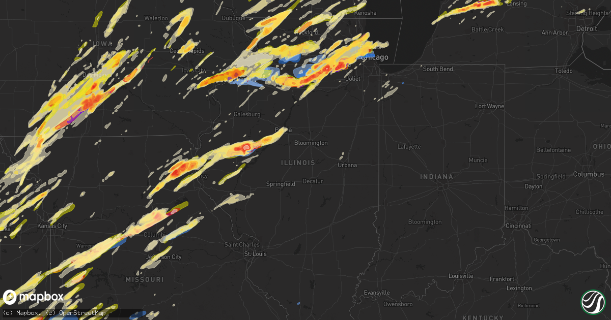
Hail Map in Illinois on April 4, 2023
Get this storm
April 4 map
$229
one time, instant access
Download today. No call, no setup
Keep the $229
Bought the map and want the full workflow? Apply the entire $229 to a subscription within 7 days. None of it is wasted.
Every map, not just this one
This buys you this map. Subscription and you get every map we run, in the markets you choose from a few cities to whole states to nationwide. Plus real-time alerts the moment a storm fires.
Contact data
Name, contact info, occupancy, even credit band for addresses in the footprint. You go from where it hit to who to call.
Become the source they trust
Unlimited branding weather history reports on demand. You already have the documented answer ready for the property owner, and you are the one who showed up with it.
Property data and RoofTrace estimates
Pull up any address you have got, its value and the exact code rules for that jurisdiction, straight from One Click Code. Then RoofTrace estimates the squares, pitch, and roof value, priced the way you price.
Storm reports in Illinois
Illinois
| Date | Description |
|---|---|
| 04/04/20236:57 PM CDT | A local report indicates a tornado near 4 E INDUSTRY |
| 04/04/20236:56 PM CDT | A local report indicates 2.50 inch wind near 4 NE INDUSTRY |
| 04/04/20236:52 PM CDT | A local report indicates 2.00 inch wind near 2 S INDUSTRY |
| 04/04/20236:49 PM CDT | Also quarter sized hail. |
| 04/04/20236:15 PM CDT | Tree reported down on county road 650 n. |
| 04/04/20236:10 PM CDT | Power line reported down in bowen. |
| 04/04/20236:00 PM CDT | A local report indicates 1.00 inch wind near 4 ESE RUSHVILLE |
| 04/04/20235:59 PM CDT | A local report indicates 1.00 inch wind near 1 W QUINCY |
| 04/04/20235:58 PM CDT | A local report indicates 1.00 inch wind near 1 NNW QUINCY |
| 04/04/20232:58 PM CDT | A local report indicates 1.25 inch wind near PORTAGE PARK - CHICAGO |
| 04/04/20232:52 PM CDT | A few trees uprooted and one tree leaning on a garage in westchester. Time estimated by radar. |
| 04/04/20232:40 PM CDT | A local report indicates 1.75 inch wind near HIGHLAND PARK |
| 04/04/20232:39 PM CDT | A local report indicates 1.50 inch wind near HIGHWOOD |
| 04/04/20232:39 PM CDT | Relayed via mping. |
| 04/04/20232:33 PM CDT | A local report indicates 1.00 inch wind near HIGHLAND PARK |
| 04/04/20232:32 PM CDT | Hail dented cars and broke headlights and taillights. |
| 04/04/20232:31 PM CDT | A local report indicates 1.00 inch wind near LINCOLNSHIRE |
| 04/04/20232:31 PM CDT | Via twitter. |
| 04/04/20232:30 PM CDT | A local report indicates 1.50 inch wind near DEERFIELD |
| 04/04/20232:29 PM CDT | Relayed via mping. |
| 04/04/20232:22 PM CDT | A local report indicates 1.00 inch wind near 1 ESE WHEELING |
| 04/04/20232:19 PM CDT | A local report indicates 1.00 inch wind near 1 NW GLENCOE |
| 04/04/20232:18 PM CDT | Almost golf ball size. Near palatine and rohlwing roads. Hail ended. |
| 04/04/20232:18 PM CDT | Multiple reports of hail quarter to golf ball size in palatine. Relayed via mping. |
| 04/04/20232:14 PM CDT | Most hailstones were roughly penny size... Though the largest were measured to be about 1.5 inches in diameter. |
| 04/04/20232:12 PM CDT | A local report indicates 1.50 inch wind near 1 W ARLINGTON HEIGHTS |
| 04/04/20232:11 PM CDT | Via twitter. |
| 04/04/20232:10 PM CDT | Time estimated from radar. |
| 04/04/20232:10 PM CDT | A local report indicates 1.75 inch wind near HARWOOD HEIGHTS |
| 04/04/20232:10 PM CDT | A local report indicates 1.00 inch wind near 2 SW GLENVIEW |
| 04/04/20232:09 PM CDT | Cumberland and touhy. |
| 04/04/20232:08 PM CDT | Hail dented roofs and cars. |
| 04/04/20232:07 PM CDT | Photo shared on social media showed a tree roughly 1 foot in diameter tree snapped at base and downed on car. Time estimated by radar. |
| 04/04/20232:07 PM CDT | Corrects time of previous hail report from skokie. Relayed via twitter. |
| 04/04/20232:07 PM CDT | Half dollar size hail reported in rogers park community area of chicago. Time estimated by radar. |
| 04/04/20232:06 PM CDT | Chicago fire dept repots via social media roof damage near north avenue and wells street. Time estimated by radar. |
| 04/04/20232:06 PM CDT | Quarter size hail in west ridge area of chicago. Time estimated by radar. |
| 04/04/20232:05 PM CDT | Quarter size hail near oakton and dodge. Time estimated by radar. |
| 04/04/20232:05 PM CDT | Roofing material peeled off of vienna factory and deposited into the chicago river. Time estimated from radar. |
| 04/04/20232:04 PM CDT | Photo shared to social media shows large branches downed on cars in wicker park area of chicago. Report indicates that wind last just 30 seconds in an area of no rainfa |
| 04/04/20232:04 PM CDT | 5600 block of west bryn mawr ave. |
| 04/04/20232:03 PM CDT | Most hailstones were closer to nickel size... But largest hailstones were roughly 1.25 inches in diameter. |
| 04/04/20232:02 PM CDT | Golf ball hail reported in far northwest chicago. Time estimated by radar. |
| 04/04/20232:02 PM CDT | Time estimated from radar. |
| 04/04/20232:02 PM CDT | Time estimated from radar. |
| 04/04/20232:01 PM CDT | Chicago fire dept repots via social media roof damage near grand avenue and division street. Time estimated by radar. |
| 04/04/20232:01 PM CDT | A local report indicates 1.00 inch wind near 1 N NORWOOD PARK - CHIC |
| 04/04/20232:00 PM CDT | Chicago fire dept repots via social media roof damage near grand avenue and north avenue. Time estimated by radar. |
| 04/04/20232:00 PM CDT | A local report indicates 1.25 inch wind near 1 SE ALBANY PARK - CHIC |
| 04/04/20231:58 PM CDT | A local report indicates 1.00 inch wind near 2 S MOUNT PROSPECT |
| 04/04/20231:58 PM CDT | Corrects time of previous hail report from portage park - chicago. |
| 04/04/20231:55 PM CDT | Photo shows large branch snapped... Blocking thatcher avenue south of north avenue in river forest. |
| 04/04/20231:55 PM CDT | A local report indicates 1.50 inch wind near NORRIDGE |
| 04/04/20231:54 PM CDT | Numerous trees uprooted... Windows blown out near lake street and oak park avenue in oak park. Time estimated by radar. |
| 04/04/20231:53 PM CDT | Near grand and mannheim roads. |
| 04/04/20231:52 PM CDT | Corrects time of previous report from 1 nne westchester. A few trees uprooted and one tree leaning on a garage in westchester. Time estimated by radar. |
| 04/04/20231:51 PM CDT | Time estimated by radar. |
| 04/04/20231:50 PM CDT | Measured on personal weather station kilpopla17. Several large trees in the area uprooted or damaged... Fascia peeled off of houses... And a shed blown off of its found |
| 04/04/20231:50 PM CDT | Golfball hail reported near ivory lane and spaulding road. Time estimated by radar. |
| 04/04/20231:49 PM CDT | Private weather station recorded 69 mph gust from the west. |
| 04/04/20231:40 PM CDT | A local report indicates 1.00 inch wind near 1 NW VILLA PARK |
| 04/04/20231:39 PM CDT | A local report indicates 1.00 inch wind near SOUTH BELOIT |
| 04/04/20231:32 PM CDT | Near west aurora high school. |
| 04/04/20231:32 PM CDT | Ping pong ball sized hail at college of dupage. |
| 04/04/20231:32 PM CDT | A local report indicates 1.00 inch wind near GLEN ELLYN |
| 04/04/20231:31 PM CDT | A local report indicates 1.00 inch wind near 1 E ALGONQUIN |
| 04/04/20231:30 PM CDT | A local report indicates 1.00 inch wind near WHEATON |
| 04/04/20231:29 PM CDT | A local report indicates 1.00 inch wind near ROCKTON |
| 04/04/20231:28 PM CDT | Approximately 1 mile southwest of i-88 and farnsworth. Via twitter. |
| 04/04/20231:21 PM CDT | A local report indicates 1.25 inch wind near 1 NW ST. CHARLES |
| 04/04/20231:20 PM CDT | Report from mping: quarter |
| 04/04/20231:20 PM CDT | Quarter size hail reported at the kane county government center. Time estimated by radar. |
| 04/04/20231:20 PM CDT | Time estimated by radar. |
| 04/04/20231:19 PM CDT | A local report indicates 1.75 inch wind near 2 W WARRENVILLE |
| 04/04/20231:18 PM CDT | A local report indicates 1.75 inch wind near 1 ENE HAMPSHIRE |
| 04/04/20231:15 PM CDT | A local report indicates 1.50 inch wind near 3 E NORTH AURORA |
| 04/04/20231:15 PM CDT | A local report indicates 1.50 inch wind near BATAVIA |
| 04/04/20231:14 PM CDT | Gold ball hail near il64 and dean. Time estimated by radar. |
| 04/04/20231:13 PM CDT | A local report indicates 1.25 inch wind near 3 WSW NAPERVILLE |
| 04/04/20231:11 PM CDT | Time estimated by radar. |
| 04/04/20231:10 PM CDT | Reported at aurora university. |
| 04/04/20231:10 PM CDT | Time estimated by radar. |
| 04/04/20231:09 PM CDT | Time estimated by radar. |
| 04/04/20231:09 PM CDT | Time estimated by radar. 00 7 s indianola warren ia 4126 9358 report from mping. |
| 04/04/20231:08 PM CDT | Reported at east aurora high school. |
| 04/04/20231:08 PM CDT | Time estimated by radar. |
| 04/04/20231:07 PM CDT | Hail damage to numerous vehicles near 2300 us34 in oswego. Time estimated by radar. |
| 04/04/20231:07 PM CDT | Time estimated by radar. |
| 04/04/20231:07 PM CDT | Delayed report. Briarcliff road and us 30 in montgomery. |
| 04/04/20231:07 PM CDT | Time estimated by radar. |
| 04/04/20231:06 PM CDT | Hail up to 2 inch diameter near il-25 and boulder hill pass. Time estimated by radar. |
| 04/04/20231:04 PM CDT | Time estimated from radar. |
| 04/04/20231:04 PM CDT | Dolores street and charles court in oswego. Via twitter. |
| 04/04/20231:04 PM CDT | Hail up to golf ball size in boulder hill. Damage to windows of car. Time estimated by radar. |
| 04/04/20231:04 PM CDT | A local report indicates 1.25 inch wind near OSWEGO |
| 04/04/20231:03 PM CDT | Relayed via mping. |
| 04/04/20231:03 PM CDT | Relayed via mping. |
| 04/04/20231:03 PM CDT | Corrects time for previous hail report from montgomery. Hail up to golf ball size... For past 5 minutes. |
| 04/04/20231:01 PM CDT | Relayed via mping. |
| 04/04/20231:00 PM CDT | A local report indicates 1.25 inch wind near 3 W MONTGOMERY |
| 04/04/20231:00 PM CDT | A local report indicates 1.75 inch wind near 2 WSW MONTGOMERY |
| 04/04/20231:00 PM CDT | A local report indicates 1.50 inch wind near ROCKTON |
| 04/04/20231:00 PM CDT | Time estimated by radar. |
| 04/04/20231:00 PM CDT | A local report indicates 1.75 inch wind near YORKVILLE |
| 04/04/20231:00 PM CDT | Golfball hail near main and harter road in kaneville. Time estimated by radar. |
| 04/04/202312:58 PM CDT | Relayed via mping. |
| 04/04/202312:56 PM CDT | Time estimated by radar. |
| 04/04/202312:54 PM CDT | A local report indicates 1.00 inch wind near 1 NE YORKVILLE |
| 04/04/202312:52 PM CDT | Relayed via mping. |
| 04/04/202312:50 PM CDT | Time estimated by radar. |
| 04/04/202312:49 PM CDT | Relayed via mping. |
| 04/04/202312:48 PM CDT | Trained spotter reports half dollar hail east of sandwich. Time estimated by radar. |
| 04/04/202312:46 PM CDT | A local report indicates 2.75 inch wind near SANDWICH |
| 04/04/202312:45 PM CDT | Relayed via mping. |
| 04/04/202312:33 PM CDT | Time estimated by radar. |
| 04/04/202312:25 PM CDT | Photo shared to social media shows hail at least tennis ball size near leland. Allegan mi 4266 8564 car windshields cracked. |
| 04/04/202312:25 PM CDT | Photo shared to social media shows hail at least tennis ball size near leland. |
| 04/04/202312:21 PM CDT | Time estimated by radar. |
| 04/04/202312:20 PM CDT | Time estimated by radar. |
| 04/04/202312:20 PM CDT | A local report indicates 2.50 inch wind near 3 S EARLVILLE |
| 04/04/202312:17 PM CDT | Ogle county em reports ping pong ball hail near il-64 and blackhawk road east of oregon. |
| 04/04/202312:15 PM CDT | Semi tipped over on i-88 near robbins road. Time estimated by radar. |
| 04/04/202312:15 PM CDT | Public report of quarter sized hail east of mendota. |
| 04/04/202312:10 PM CDT | Semi tipped over on il-38 east of dixon. Time estimated by radar. |
| 04/04/202312:10 PM CDT | Private weather station recorded 66 mph wind gust with an abrupt wind shift from easterly to westerly... Then back to easterly. |
| 04/04/202312:05 PM CDT | Semi tipped over on i-88 near atkinson road. Possible injuries. Time estimated by radar. |
| 04/04/202312:05 PM CDT | A local report indicates 1.00 inch wind near EARLVILLE |
| 04/04/202312:02 PM CDT | Video shared by public via social media shows structural damage near 2nd and college in dixon. Time estimated by radar. |
| 04/04/202312:02 PM CDT | Trained spotter reports quarter size hail on the south side of mendota. |
| 04/04/202312:00 PM CDT | Semi tipped over on us30 near harmon. Time estimated by radar. |
| 04/04/202311:57 AM CDT | Relayed via spotter network. |
| 04/04/202311:49 AM CDT | Report of 2.5 inch hail near troy grove relayed via spotter network. |
| 04/04/202311:45 AM CDT | Report shared via social media of golf ball hail in mendota. |
| 04/04/202311:38 AM CDT | A local report indicates 1.75 inch wind near CHERRY |
| 04/04/202311:35 AM CDT | A local report indicates 1.25 inch wind near MILLEDGEVILLE |
| 04/04/202311:35 AM CDT | Pea to quarters. |
| 04/04/202311:34 AM CDT | A local report indicates 2.00 inch wind near 2 ESE CHERRY |
| 04/04/202311:30 AM CDT | Delayed report. |
| 04/04/202311:24 AM CDT | A local report indicates 1.75 inch wind near MALDEN |
| 04/04/202311:23 AM CDT | A local report indicates 1.50 inch wind near MALDEN |
| 04/04/202311:15 AM CDT | Pea to quarters. |
| 04/04/202310:58 AM CDT | A local report indicates 1.75 inch wind near 1 SE NEW BEDFORD |
| 04/04/202310:58 AM CDT | A local report indicates 1.75 inch wind near 1 SE NEW BEDFORD |
| 04/04/202310:40 AM CDT | New spotter. |
| 04/04/202310:35 AM CDT | Snapped tree... Report from social media. |
| 04/04/202310:25 AM CDT | Report from mping: quarter |
| 04/04/202310:20 AM CDT | Semi trailer blown over 3 miles west of atkinson on interstate 80. |
| 04/04/20239:58 AM CDT | Several structures within the town of colona with collapsed roofs and damage. |
| 04/04/20239:57 AM CDT | Brief tornado. Ripped off the entire roof of a gas station and tossed it into a brick building to the south. The front wall of this building collapsed. The tornado also |
| 04/04/20239:53 AM CDT | Power poles down and sign damage at applebees in moline winds estimated over 80 mph. |
| 04/04/20239:50 AM CDT | Two trees down approx. 12 inches in diameter with numerous limbs down...time estimated from radar. |
| 04/04/20239:48 AM CDT | Downed trees on 15th ave and steves bellgrade bar roof taken off near 16th st...time estimated from radar. |
| 04/04/20239:46 AM CDT | Asos station kmli quad city intl arpt. |
| 04/04/20239:43 AM CDT | Multiple trees and branches down... Shingles off roof... And no power. Cant get out of neighborhood at the moment...time estimated from radar. |
| 04/04/20239:37 AM CDT | Roof damage... Downed trees with root balls... Semi trailers blown over. |
| 04/04/20236:54 AM CDT | Reported at dry grove township: street sign bent over 90 degrees. 1 mile east of the sign there was house with a tree down and a truck had its cover torn off. 1 mile ea |
| 04/04/20236:29 AM CDT | Measured at kilsycam22 pws. |
| 04/04/20236:25 AM CDT | A local report indicates 59 MPH wind near 1 NE DEKALB |
| 04/04/20236:16 AM CDT | Peak gust measured at pws. |
| 04/04/20236:11 AM CDT | Possible tornado. Tree downed on power line. Time estimated by radar. |
| 04/04/20236:04 AM CDT | A local report indicates 79 MPH wind near 4 S COMPTON |
| 04/04/20236:01 AM CDT | Possible tornado. Lee county sherriff office reports three power poles snapped in the vicinity of shaw and brooklyn roads. Damage was in close proximity to radar-indica |
| 04/04/20235:25 AM CDT | Power line down in nebo... Il. Time estimated from radar. |
| 04/04/20235:10 AM CDT | A local report indicates 1.50 inch wind near NORA |
| 04/04/20235:05 AM CDT | Hail covering the deck with the largest stones at 1 inch. |
| 04/04/20234:48 AM CDT | A brief tornado began just east of i-74 north of woodhull damaging trees... A few outbuildings... And a home along its path. A home lost some shingles and a partial roo |
| 04/04/20234:45 AM CDT | Asos station kmdh carbondale il. |
| 04/04/20234:42 AM CDT | Tree down blocking the road. |
| 04/04/20234:12 AM CDT | Pea sized hail was also reported. |
| 04/03/20239:40 PM CDT | A local report indicates 1.75 inch wind near 1 S WINSLOW |
| 04/03/20239:37 PM CDT | A local report indicates 1.75 inch wind near 1 WSW RED OAK |
| 04/03/20239:23 PM CDT | A local report indicates 1.75 inch wind near 2 NE PLUM RIVER |
| 04/03/20238:08 PM CDT | A local report indicates 1.50 inch wind near BELLEVUE |
| 04/03/20237:41 PM CDT | A local report indicates 1.75 inch wind near 1 SW BANNER |
| 04/03/20237:27 PM CDT | Spotter reported large cone just north of lewistown... With a second tornado further east. |
| 04/03/20237:25 PM CDT | Photo from social media shows mangled farm equipment in the road. |
| 04/03/20237:25 PM CDT | A local report indicates a tornado near 1 N LEWISTOWN |
| 04/03/20237:24 PM CDT | A local report indicates a tornado near 1 N LEWISTOWN |
| 04/03/20237:18 PM CDT | A local report indicates a tornado near 1 NW DUNCAN MILLS |
| 04/03/20237:14 PM CDT | A local report indicates a tornado near 1 NE IPAVA |
| 04/03/20237:07 PM CDT | Trees and powerlines down; possible tornado. |
| 04/03/20237:07 PM CDT | A local report indicates a tornado near TABLE GROVE |
| 04/03/20237:05 PM CDT | Multiple chasers have busted windshields due to baseball size hail near vermont. |
| 04/03/20237:04 PM CDT | Report from mping: baseball+ |
| 04/03/20237:04 PM CDT | Powerlines down. |
| 04/03/20237:03 PM CDT | A local report indicates 2.75 inch wind near TABLE GROVE |
All States Impacted by Hail Map on April 4, 2023
Cities Impacted by Hail Map on April 4, 2023
- Williamsburg, IA
- Homestead, IA
- South Amana, IA
- Marengo, IA
- Conesville, IA
- Columbus Junction, IA
- Lone Tree, IA
- Nichols, IA
- Fairfax, IA
- Cedar Rapids, IA
- Marion, IA
- Springville, IA
- Letts, IA
- Muscatine, IA
- Atalissa, IA
- Moscow, IA
- Wilton, IA
- West Liberty, IA
- Stockton, IA
- Blue Grass, IA
- Durant, IA
- Davenport, IA
- Walcott, IA
- Eldridge, IA
- Bettendorf, IA
- Le Claire, IA
- Dixon, IA
- Long Grove, IA
- Donahue, IA
- Princeton, IA
- Port Byron, IL
- Hillsdale, IL
- Geneseo, IL
- Erie, IL
- Prophetstown, IL
- Taylor Ridge, IL
- Andalusia, IL
- Buffalo, IA
- Milan, IL
- Rock Island, IL
- Fulton, IL
- Fenton, IL
- Morrison, IL
- Albany, IL
- Coal Valley, IL
- Moline, IL
- Sterling, IL
- East Moline, IL
- Silvis, IL
- Clinton, IA
- Thomson, IL
- Mount Carroll, IL
- Savanna, IL
- Chadwick, IL
- Colona, IL
- Milledgeville, IL
- Polo, IL
- Lanark, IL
- Atkinson, IL
- Dixon, IL
- Woosung, IL
- Oregon, IL
- Ashton, IL
- Franklin Grove, IL
- Mount Morris, IL
- Chana, IL
- Forreston, IL
- Annawan, IL
- Hooppole, IL
- Lyndon, IL
- Tampico, IL
- New Bedford, IL
- Deer Grove, IL
- Rock Falls, IL
- Walnut, IL
- Sheffield, IL
- Manlius, IL
- Wyanet, IL
- Princeton, IL
- Ohio, IL
- Malden, IL
- Arlington, IL
- Dover, IL
- Dalzell, IL
- Spring Valley, IL
- Ladd, IL
- La Moille, IL
- Harmon, IL
- Mendota, IL
- Cherry, IL
- Peru, IL
- La Salle, IL
- Troy Grove, IL
- Van Orin, IL
- Earlville, IL
- Triumph, IL
- Utica, IL
- Sublette, IL
- Steward, IL
- Lee, IL
- Shabbona, IL
- Malta, IL
- Waterman, IL
- Dekalb, IL
- De Witt, IA
- Felicity, OH
- Wheatland, IA
- New Liberty, IA
- Riverside, IA
- Ainsworth, IA
- Sardinia, OH
- Washington, IA
- North English, IA
- South English, IA
- Webster, IA
- Monroe Center, IL
- Rochelle, IL
- Stillman Valley, IL
- Davis Junction, IL
- Grand Mound, IA
- Georgetown, OH
- Hamersville, OH
- Delmar, IA
- West Branch, IA
- Iowa City, IA
- Kirkland, IL
- Kingston, IL
- Bethel, OH
- Hiawatha, IA
- Cordova, IL
- Lindenwood, IL
- Esmond, IL
- Amana, IA
- Calamus, IA
- Byron, IL
- Holcomb, IL
- Genoa, IL
- Mineral, IL
- Leland, IL
- Bryant, IA
- Goose Lake, IA
- Amboy, IL
- McCausland, IA
- Camanche, IA
- Hampton, IL
- Rapids City, IL
- Pleasant Valley, IA
- Sabula, IA
- Clare, IL
- Sheridan, IL
- Somonauk, IL
- Sandwich, IL
- Plano, IL
- Yorkville, IL
- Cortland, IL
- Oswego, IL
- Sycamore, IL
- Bristol, IL
- Montgomery, IL
- Aurora, IL
- Plainfield, IL
- Naperville, IL
- Sugar Grove, IL
- Big Rock, IL
- Lisle, IL
- Downers Grove, IL
- Warrenville, IL
- Wheaton, IL
- Lombard, IL
- Glen Ellyn, IL
- North Aurora, IL
- Winfield, IL
- Batavia, IL
- West Chicago, IL
- Villa Park, IL
- Elmhurst, IL
- Addison, IL
- Melrose Park, IL
- Franklin Park, IL
- Bensenville, IL
- River Grove, IL
- Chicago, IL
- Schiller Park, IL
- Harwood Heights, IL
- Lincolnwood, IL
- Evanston, IL
- Skokie, IL
- Morton Grove, IL
- Rockford, IL
- Winnebago, IL
- Rockton, IL
- Roscoe, IL
- South Beloit, IL
- Machesney Park, IL
- Clinton, WI
- Caledonia, IL
- Poplar Grove, IL
- Capron, IL
- Harvard, IL
- Sharon, WI
- Park Ridge, IL
- Des Plaines, IL
- Niles, IL
- Walworth, WI
- Darien, WI
- Fontana, WI
- Lake Geneva, WI
- Hebron, IL
- Wood Dale, IL
- Carol Stream, IL
- Glendale Heights, IL
- Mooseheart, IL
- Geneva, IL
- Pecatonica, IL
- Sedalia, MO
- Green Ridge, MO
- La Monte, MO
- Hughesville, MO
- Berkeley, IL
- Bellwood, IL
- Maywood, IL
- Stone Park, IL
- River Forest, IL
- Elmwood Park, IL
- Northbrook, IL
- Highland Park, IL
- Deerfield, IL
- Highwood, IL
- Glencoe, IL
- Wheeling, IL
- Mount Prospect, IL
- Arlington Heights, IL
- Prospect Heights, IL
- Lake Forest, IL
- Buffalo Grove, IL
- Lincolnshire, IL
- Palatine, IL
- Rolling Meadows, IL
- Hoffman Estates, IL
- Barrington, IL
- Schaumburg, IL
- Lake Zurich, IL
- Hinckley, IL
- Elburn, IL
- Maple Park, IL
- Blackwater, MO
- Franklin, MO
- Boonville, MO
- Fayette, MO
- New Franklin, MO
- Rocheport, MO
- Harrisburg, MO
- Newark, IL
- Sturgeon, MO
- Columbia, MO
- Clark, MO
- Centralia, MO
- Oak Brook, IL
- Hillside, IL
- Westchester, IL
- Hines, IL
- Forest Park, IL
- Broadview, IL
- Oak Park, IL
- Berwyn, IL
- Cicero, IL
- Mexico, MO
- Thompson, MO
- Santa Fe, MO
- Paris, MO
- Perry, MO
- Stoutsville, MO
- Paw Paw, IL
- Stuart, IA
- Redfield, IA
- Linden, IA
- Bedford, IA
- New Market, IA
- Gravity, IA
- Hopkins, MO
- Pickering, MO
- Anabel, MO
- Clarence, MO
- Lenox, IA
- Sharpsburg, IA
- Corning, IA
- Perry, IA
- Bouton, IA
- Woodward, IA
- Shelbyville, MO
- Leonard, MO
- Newark, MO
- Saint Charles, IL
- Knox City, MO
- La Belle, MO
- Bethel, MO
- Prescott, IA
- Creston, IA
- Wayne, IL
- Cromwell, IA
- South Elgin, IL
- Bartlett, IL
- Elgin, IL
- Streamwood, IL
- Hanover Park, IL
- Orient, IA
- Lewistown, MO
- Greenfield, IA
- Wasco, IL
- Ewing, MO
- Maryville, MO
- Sheridan, MO
- Blockton, IA
- Clearfield, IA
- Benton, IA
- Fennville, MI
- Allegan, MI
- Hopkins, MI
- La Grange, MO
- Monticello, MO
- Canton, MO
- Warsaw, IL
- Ursa, IL
- Sutter, IL
- Mendon, IL
- Shelbyville, MI
- Wayland, MI
- Skidmore, MO
- Edina, MO
- Novelty, MO
- Tipton, IA
- Salem, WI
- Burlington, WI
- Kansasville, WI
- Hurdland, MO
- Sturtevant, WI
- Union Grove, WI
- East Lynn, WV
- Branchland, WV
- La Plata, MO
- Leaf River, IL
- Blairstown, MO
- Leeton, MO
- Chilhowee, MO
- Urich, MO
- Holden, MO
- Bevier, MO
- Excello, MO
- Kenosha, WI
- Racine, WI
- Nodaway, IA
- Elkhorn, WI
- Delavan, WI
- East Troy, WI
- Macon, MO
- Hillsboro, OH
- Winchester, OH
- Carpentersville, IL
- Jacksonville, MO
- Hampshire, IL
- Huntley, IL
- Gilberts, IL
- Dundee, IL
- Genoa City, WI
- Hallsville, MO
- Pilot Grove, MO
- Wilmette, IL
- Glenview, IL
- Golf, IL
- Winnetka, IL
- Woodstock, IL
- Marengo, IL
- Burlington Junction, MO
- Braddyville, IA
- Clearmont, MO
- Myra, WV
- Hamlin, WV
- Libertyville, IL
- Vernon Hills, IL
- Algonquin, IL
- Belvidere, IL
- Garden Prairie, IL
- Houstonia, MO
- Williams Bay, WI
- Mundelein, IL
- Loves Park, IL
- Nelson, MO
- Middleville, MI
- Kenilworth, IL
- Hunnewell, MO
- Woodridge, IL
- Itasca, IL
- Elk Grove Village, IL
- Compton, IL
- Monroe City, MO
- Emden, MO
- Philadelphia, MO
- Palmyra, MO
- Maywood, MO
- Taylor, MO
- Quincy, IL
- Mount Ayr, IA
- Diagonal, IA
- Tingley, IA
- Ellston, IA
- Shannon City, IA
- Thayer, IA
- Murray, IA
- Afton, IA
- Baylis, IL
- Liberty, IL
- Mount Sterling, IL
- Clayton, IL
- Versailles, IL
- Timewell, IL
- Rushville, IL
- Frederick, IL
- Ogden, IA
- Boone, IA
- Loraine, IL
- Osceola, IA
- West Point, IL
- Fowler, IL
- Hastings, MI
- Coatsburg, IL
- Golden, IL
- New Virginia, IA
- Truro, IA
- Basco, IL
- Carthage, IL
- Jewell, IA
- Kamrar, IA
- Williams, IA
- Blairsburg, IA
- Browning, IL
- Ellsworth, IA
- Dows, IA
- Hubbard, IA
- Radcliffe, IA
- Eldora, IA
- Iowa Falls, IA
- Ackley, IA
- Robinson, KS
- Geneva, IA
- Highland, KS
- Troy, KS
- Forest City, MO
- Oregon, MO
- Carbon Cliff, IL
- Maitland, MO
- Alden, IA
- Bolckow, MO
- Fillmore, MO
- Belmond, IA
- Bowen, IL
- Augusta, IL
- Meservey, IA
- Goodell, IA
- Colchester, IL
- Plymouth, IL
- Tennessee, IL
- Klemme, IA
- Woodburn, IA
- Lucas, IA
- Milo, IA
- Indianola, IA
- Liberty Center, IA
- Lacona, IA
- Freeport, MI
- Lake Odessa, MI
- Woodland, MI
- Vermontville, MI
- Pleasantville, IA
- Knoxville, IA
- Ackworth, IA
- Dumont, IA
- Mulliken, MI
- Sunfield, MI
- Bondurant, IA
- Maxwell, IA
- Mingo, IA
- Colfax, IA
- Collins, IA
- Baxter, IA
- Rhodes, IA
- Macomb, IL
- Ira, IA
- Vermont, IL
- Industry, IL
- Adair, IL
- Bridgewater, IA
- Fontanelle, IA
- Littleton, IL
- Table Grove, IL
- Melbourne, IA
- Ipava, IL
- State Center, IA
- Marshalltown, IA
- Marietta, IL
- Smithfield, IL
- Otley, IA
- Pella, IA
- Haverhill, IA
- Monroe, IA
- Swan, IA
- Lewistown, IL
- Cuba, IL
- Graham, MO
- Barnard, MO
- Grand Ledge, MI
- Charlotte, MI
- Portland, MI
- Eagle, MI
- La Pryor, TX
- Crystal City, TX
- Lansing, MI
- Batesville, TX
- Reasnor, IA
- Sully, IA
- Lynnville, IA
- Bryant, IL
- Canton, IL
- Saint David, IL
- Searsboro, IA
- Grinnell, IA
- Manito, IL
- Glasford, IL
- Hiawatha, KS
- Falls City, NE
- Kingston Mines, IL
- Mapleton, IL
- Winterset, IA
- Astoria, IL
- Van Meter, IA
- Cumming, IA
- West Des Moines, IA
- Waukee, IA
- Peoria, IL
- Malcom, IA
- Bristol, WI
- Craig, MO
- Mound City, MO
- Eskridge, KS
- Alma, KS
- Harveyville, KS
- Des Moines, IA
- Altoona, IA
- Brooklyn, IA
- Chelsea, IA
- Rossville, KS
- Topeka, KS
- Silver Lake, KS
- Delia, KS
- Mayetta, KS
- Hoyt, KS
- Meriden, KS
- Denison, KS
- Valley Falls, KS
- Muscotah, KS
- Effingham, KS
- Tama, IA
- Elberon, IA
- Vining, IA
- Grantville, KS
- Ottawa, IL
- Admire, KS
- Emporia, KS
- Reading, KS
- Mitchellville, IA
- Ozawkie, KS
- Miles, IA
- Newton, IA
- Preston, IA
- Bendena, KS
- Laurel, IA
- Atchison, KS
- Van Horne, IA
- Keystone, IA
- Garrison, IA
- Oskaloosa, KS
- Vinton, IA
- Winchester, KS
- Osage City, KS
- Elizabeth, IL
- Lorimor, IA
- Macksburg, IA
- Peru, IA
- Urbana, IA
- Center Point, IA
- Walker, IA
- Saint Charles, IA
- Prole, IA
- Patterson, IA
- Bevington, IA
- Norwalk, IA
- Stockton, IL
- Saint Marys, IA
- Martensdale, IA
- Winthrop, IA
- Coggon, IA
- Carlisle, IA
- Rowley, IA
- Independence, IA
- Quasqueton, IA
- Burlingame, KS
- Scranton, KS
- Carbondale, KS
- Cummings, KS
- Nortonville, KS
- Easton, KS
- Weston, MO
- Rushville, MO
- Gilman, IA
- Runnells, IA
- Pleasant Hill, IA
- Pearl City, IL
- Montour, IA
- Kent, IL
- Lena, IL
- McConnell, IL
- Masonville, IA
- Berryton, KS
- Lecompton, KS
- Lawrence, KS
- Freeport, IL
- Winslow, IL
- De Kalb, MO
- Lamont, IA
- Prairie City, IA
- Orangeville, IL
- Dakota, IL
- Monroe, WI
- Perry, KS
- Juda, WI
- Chatfield, MN
- Aledo, TX
- Granbury, TX
- Fort Scott, KS
- Hico, TX
- Mill Creek, OK
- Holdenville, OK
- Newhall, IA
- Moravia, IA
- Delta, IA
- Stonewall, OK
- Rhome, TX
- Chula, MO
- Beggs, OK
- Hume, MO
- Pleasant Hill, MO
- Hardin, MO
- Adrian, MO
- Shellsburg, IA
- Wheeling, MO
- Blakesburg, IA
- Walnut Springs, TX
- Oswego, KS
- Broken Arrow, OK
- Keswick, IA
- Chillicothe, MO
- Ottumwa, IA
- Krum, TX
- Atkins, IA
- Farlington, KS
- Sanger, TX
- Albia, IA
- Tishomingo, OK
- Bluffton, TX
- Hamilton, TX
- What Cheer, IA
- Centerville, IA
- Columbus, KS
- Mounds, OK
- Fredericksburg, TX
- Eddyville, IA
- Butler, MO
- Rose Hill, IA
- Vinita, OK
- Fremont, IA
- Kingsville, MO
- Lexington, MO
- Fort Worth, TX
- Bandera, TX
- Girard, KS
- Henryetta, OK
- Mannsville, OK
- Odessa, MO
- Madill, OK
- Gainesville, TX
- Lebanon, OK
- Archie, MO
- Cincinnati, IA
- Wetumka, OK
- Bixby, OK
- Cedar, IA
- Milan, MO
- Allen, OK
- Welch, OK
- Humphreys, MO
- Rich Hill, MO
- Lometa, TX
- Chelsea, OK
- Center Point, TX
- Norborne, MO
- Hondo, TX
- Okmulgee, OK
- Claremore, OK
- Valley View, TX
- Catoosa, OK
- Ponder, TX
- Mayview, MO
- Unionville, MO
- Bates City, MO
- Llano, TX
- Glen Rose, TX
- Deep River, IA
- Chetopa, KS
- Garden City, MO
- Pollock, MO
- Dawn, MO
- Iredell, TX
- Atwood, OK
- Weleetka, OK
- Justin, TX
- Exline, IA
- Brodhead, WI
- Dearborn, MO
- Faucett, MO
- Agency, MO
- Big Wells, TX
- Pearsall, TX
- Dilley, TX
- Saint Charles, MN
- Moore, TX
- Saint Joseph, MO
- Overbrook, KS
- South Haven, MI
- Pullman, MI
- Belmont, WI
- Mineral Point, WI
- Hamilton, MI
- Dodgeville, WI
- Albion, IA
- Liscomb, IA
- Grundy Center, IA
- Cochrane, WI
- Arcadia, WI
- Fountain City, WI
- Spring Valley, MN
- Cambridge, IA
- Nevada, IA
- Elkhart, IA
- Ankeny, IA
- Rudd, IA
- Floyd, IA
- Kanawha, IA
- Rock City, IL
- Davis, IL
- Bivins, TX
- Manly, IA
- Kensett, IA
- Hanlontown, IA
- Austin, MN
- Glenville, MN
- Clear Lake, IA
- Northwood, IA
- Clemons, IA
- Union, IA
- Garner, IA
- Mason City, IA
- Thornton, IA
- Ventura, IA
- Clarion, IA
- Barry, IL
- Whiting, KS
- Holton, KS
- Eureka Springs, AR
- Eagle Rock, MO
- Utica, MN
- Lewiston, MN
- Lanesboro, MN
- Wykoff, MN
- Fountain, MN
- Peterson, MN
- Greene, IA
- Colo, IA
- Casey, IA
- Sparland, IL
- Dallas Center, IA
- Ames, IA
- Dexter, IA
- Elmo, MO
- East Peoria, IL
- Parkersburg, IA
- Blair, WI
- Americus, KS
- Allen, KS
- Williamstown, MO
- Durham, MO
- Creve Coeur, IL
- Horton, KS
- Rockford, IA
- Luther, IA
- Minburn, IA
- Madrid, IA
- Maple Hill, KS
- Moberly, MO
- Huntsville, MO
- Cairo, MO
- Wetmore, KS
- Fairfax, MO
- Tarkio, MO
- Grimes, IA
- Johnston, IA
- Windsor Heights, IA
- Clarksville, IA
- Garden City, IA
- Charles City, IA
- Bristow, IA
- McCallsburg, IA
- Aplington, IA
- Allison, IA
- Eagle Pass, TX
- Auburn, KS
- Berwick, IA
- Pekin, IL
- Everest, KS
- Kahoka, MO
- Saint Patrick, MO
- Princeville, IL
- Speer, IL
- Edelstein, IL
- White Cloud, KS
- Charlotte, IA
- Teeds Grove, IA
- Menlo, IA
- Rulo, NE
- Paloma, IL
- Shelbina, MO
- La Prairie, IL
- Camp Point, IL
- Washington, IL
- Liverpool, IL
- Clarinda, IA
- Wathena, KS
- Denton, KS
- Serena, IL
- Aurora, IA
- Martin, MI
- Earlham, IA
- Adel, IA
- Villisca, IA
- Fairview, KS
- Booneville, IA
- Clive, IA
- Powhattan, KS
- De Soto, IA
- Blanchard, IA
- College Springs, IA
- Lancaster, KS
- Shambaugh, IA
- Urbandale, IA
- Ravenwood, MO
- Parnell, MO
- Netawaka, KS
- Grand River, IA
- McNabb, IL
- Standard, IL
- Granville, IL
- Hennepin, IL
- Tonica, IL
- Cedar Point, IL
- Henry, IL
- Oglesby, IL
- Farmington, IL
- Albany, WI
- Hanna City, IL
- Brooklyn, WI
- Evansville, WI
- Edgerton, WI
- Stoughton, WI
- Oregon, WI
- Spring Green, WI
- Wichita, KS
- Greenwich, KS
- Valley Center, KS
- Benton, KS
- Mulvane, KS
- Belle Plaine, KS
- Douglass, KS
- Rose Hill, KS
- Derby, KS
- Cambridge, WI
- Fort Atkinson, WI
- Jefferson, WI
- Lake Mills, WI
- Johnson Creek, WI
- Watertown, WI
- Alto, MI
- Columbus, WI
- Marshall, WI
- Fall River, WI
- New Berlin, WI
- Brookfield, WI
- Milwaukee, WI
- Elm Grove, WI
- Loganville, WI
- North Freedom, WI
- Rock Springs, WI
- Baraboo, WI
- Reedsburg, WI
- La Valle, WI
- Arlington, WI
- Poynette, WI
- Rio, WI
- Grenola, KS
- Piedmont, KS
- Howard, KS
- Severy, KS
- Fall River, KS
- Olpe, KS
- Madison, KS
- Hartford, KS
- Neosho Rapids, KS
- McLouth, KS
- Tonganoxie, KS
- Fredonia, KS
- Toronto, KS
- Yates Center, KS
- Cambria, WI
- Buffalo, KS
- Leavenworth, KS
- Fort Leavenworth, KS
- Platte City, MO
- Wayne, WV
- Iola, KS
- Humboldt, KS
- Piqua, KS
- La Harpe, KS
- Moran, KS
- Colony, KS
- Kincaid, KS
- Bronson, KS
- Blue Mound, KS
- Centerville, KS
- Marshall, MO
- Knob Noster, MO
- Windsor, MO
- Clinton, MO
- Warrensburg, MO
- Whiteman Air Force Base, MO
- Pleasanton, KS
- Mound City, KS
- La Cygne, KS
- Parker, KS
- Amoret, MO
- Cassville, MO
- Shell Knob, MO
- Golden, MO
- Amsterdam, MO
- Kansas City, MO
- Kansas City, KS
- Liberty, MO
- Kearney, MO
- Hazleton, IA
- Excelsior Springs, MO
- Rayville, MO
- Lawson, MO
- Creighton, MO
- Dundee, IA
- Centerview, MO
- Sedan, KS
- Cedar Vale, KS
- Pawhuska, OK
- Peru, KS
- Chautauqua, KS
- Caney, KS
- Niotaze, KS
- Havana, KS
- Independence, KS
- Cherryvale, KS
- Liberty, KS
- Coralville, IA
- Solon, IA
- Mechanicsville, IA
- Lisbon, IA
- Olin, IA
- Stanwood, IA
- Parsons, KS
- Mound Valley, KS
- Dennis, KS
- Galesburg, KS
- Saint Paul, KS
- Alton, MO
- Fremont, MO
- Doniphan, MO
- Van Buren, MO
- McCune, KS
- Walnut, KS
- Appleton City, MO
- Rockville, MO
- Montrose, MO
- Smithton, MO
- Franklin, AR
- Horseshoe Bend, AR
- Ash Flat, AR
- Melbourne, AR
- Sage, AR
- Evening Shade, AR
- Grandin, MO
- Ellsinore, MO
- Mill Spring, MO
- Williamsville, MO
- Piedmont, MO
- Hardy, AR
- Cherokee Village, AR
- Williford, AR
- Pittsburg, KS
- Franklin, KS
- Arma, KS
- Mulberry, KS
- Arcadia, KS
- Garland, KS
- Osceola, MO
- Deepwater, MO
- Violet Hill, AR
- Calhoun, MO
- Walker, MO
- Nevada, MO
- Harwood, MO
- Schell City, MO
- Higbee, MO
- Scammon, KS
- Cherokee, KS
- Weir, KS
- West Mineral, KS
- Ravenden Springs, AR
- Ravenden, AR
- Pocahontas, AR
- Mammoth Spring, AR
- Greenville, MO
- Asbury, MO
- Opolis, KS
- Frontenac, KS
- Mindenmines, MO
- Liberal, MO
- Osceola, WI
- Star Prairie, WI
- Neillsville, WI
- Merrillan, WI
- Eldorado, WI
- Soldiers Grove, WI
- Gays Mills, WI
- Oconomowoc, WI
- Leighton, IA
- Buckingham, IA
- Independence, WI
- Sullivan, WI
- Hixton, WI
- Muskego, WI
- Lancaster, WI
- Luck, WI
- Milltown, WI
- Hawkeye, IA
- Hartford, IA
- Franklin, WI
- Franksville, WI
- Waterford, WI
- West Union, IA
- Wadena, IA
- Elgin, IA
- Arlington, IA
- Fayette, IA
- Saint Francis, WI
- Oak Creek, WI
- Cudahy, WI
- Hartford, WI
- Plain, WI
- Sauk City, WI
- Mequon, WI
- New Vienna, IA
- North Buena Vista, IA
- Holy Cross, IA
- Browntown, WI
- Saint Croix Falls, WI
- Centuria, WI
- Dresser, WI
- Balsam Lake, WI
- Amery, WI
- Calico Rock, AR
- Janesville, WI
- Ryan, IA
- Le Grand, IA
- Garwin, IA
- Russell, IA
- Chariton, IA
- Green Bay, WI
- Burlington, IL
- Grayslake, IL
- Little Suamico, WI
- Suamico, WI
- Redding, IA
- Cowgill, MO
- Hamilton, MO
- Wellington, KS
- Toledo, IA
- Clarksdale, MO
- Cosby, MO
- Easton, MO
- Amity, MO
- Maysville, MO
- Weatherby, MO
- Pattonsburg, MO
- Wonder Lake, IL
- Central City, IA
- Clinton, AR
- Alburnett, IA
- Palo, IA
- Robins, IA
- Corydon, IA
- Allerton, IA
- Strawberry Point, IA
- La Porte City, IA
- Jesup, IA
- Brandon, IA
- Weldon, IA
- Elk City, KS
- Gower, MO
- Purdin, MO
- Browning, MO
- Linneus, MO
- Peck, KS
- Haysville, KS
- Watkins, IA
- Norway, IA
- Mount Auburn, IA
- Hattieville, AR
- Baldwin City, KS
- Ottawa, KS
- Peoria Heights, IL
- Couch, MO
- New Sharon, IA
- Hales Corners, WI
- Osborn, MO
- Stewartsville, MO
- Kechi, KS
- Clearwater, KS
- Freeport, KS
- Lovilia, IA
- Melrose, IA
- Kaukauna, WI
- Ely, IA
- Cambridge, KS
- Ferguson, IA
- Kellerton, IA
- Conception Junction, MO
- Clyde, MO
- Van Wert, IA
- Grant City, MO
- Kellogg, IA
- Tracy, IA
- Hamilton, IA
- Bussey, IA
- Neodesha, KS
- Brockwell, AR
- Cassville, WI
- Pottsville, AR
- Russellville, AR
- Princeton, MO
- Cainsville, MO
- Mercer, MO
- Dardanelle, AR
- Braymer, MO
- Kingston, MO
- Polo, MO
- Madison, MO
- Elsmore, KS
- Ola, AR
- Atkins, AR
- Ramona, OK
- Talala, OK
- Nowata, OK
- Osseo, WI
- Melcher Dallas, IA
- Warm Springs, AR
- Gatewood, MO
- Myrtle, MO
- Oronogo, MO
- Lamar, MO
- Jasper, MO
- Marble Hill, MO
- Glenallen, MO
- Patton, MO
- Adair, OK
- Big Cabin, OK
- Sheldon, MO
- Golden City, MO
- Jerico Springs, MO
- Lockwood, MO
- El Dorado Springs, MO
- Milo, MO
- Afton, OK
- Riverton, KS
- Baxter Springs, KS
- Galena, KS
- Joplin, MO
- Carl Junction, MO
- Webb City, MO
- Carthage, MO
- Fairland, OK
- Miami, OK
- Jefferson City, MO
- Centertown, MO
- Lohman, MO
- Russellville, MO
- Kingdom City, MO
- Fulton, MO
- Ashland, MO
- Auxvasse, MO
- Martinsburg, MO
- Williamsburg, MO
- Wellsville, MO
- Montgomery City, MO
- Benton City, MO
- Goodman, MO
- Neosho, MO
- Carterville, MO
- Alba, MO
- Greenfield, MO
- Reeds, MO
- Avilla, MO
- Sarcoxie, MO
- South Greenfield, MO
- Holts Summit, MO
- Hartsburg, MO
- New Bloomfield, MO
- Middletown, MO
- Vandalia, MO
- Everton, MO
- Dadeville, MO
- Aldrich, MO
- Arcola, MO
- Stockton, MO
- Fair Play, MO
- Dunnegan, MO
- Wentworth, MO
- Pierce City, MO
- Stotts City, MO
- Granby, MO
- Stark City, MO
- Monett, MO
- Freistatt, MO
- Mount Vernon, MO
- Bolivar, MO
- Humansville, MO
- Flemington, MO
- Verona, MO
- La Russell, MO
- Miller, MO
- Nora, IL
- Warren, IL
- Apple River, IL
- South Wayne, WI
- Aurora, MO
- Ash Grove, MO
- Marionville, MO
- Buffalo, MO
- Half Way, MO
- Polk, MO
- Louisburg, MO
- Murphysboro, IL
- Black Rock, AR
- Imboden, AR
- Valparaiso, IN
- Billings, MO
- Bois D Arc, MO
- Republic, MO
- Halltown, MO
- Green Forest, AR
- Oak Grove, AR
- Long Lane, MO
- Conway, MO
- Phillipsburg, MO
- Lebanon, MO
- Omaha, AR
- Blue Eye, MO
- Ridgedale, MO
- Hollister, MO
- Clever, MO
- Kirbyville, MO
- Kissee Mills, MO
- Forsyth, MO
- Powersite, MO
- Keota, OK
- Stigler, OK
- Red Oak, OK
- Kinta, OK
- Mccurtain, OK
- Harrison, AR
- Sallisaw, OK
- Gans, OK
- Muldrow, OK
- West Brooklyn, IL
- Berryville, AR
- Branson, MO
- Taneyville, MO
- Bradleyville, MO
- Cedarcreek, MO
- Rueter, MO
- Newburg, MO
- Edgar Springs, MO
- Rolla, MO
- Saint James, MO
- Salem, MO
- Rockaway Beach, MO
- Oldfield, MO
- Roland, OK
- Van Buren, AR
- Fort Smith, AR
- Rudy, AR
- Alma, AR
- Dyer, AR
- Mulberry, AR
- Ozark, AR
- Roselle, IL
- Medinah, IL
- Bloomingdale, IL
- Au Gres, MI
- Standish, MI
- Byron Center, MI
- Holton, MI
- Wellston, MI
- Buda, IL
- Benzonia, MI
- Cadillac, MI
- Helena, MO
- Shullsburg, WI
- Caledonia, WI
- Beloit, WI
- Luther, MI
- Branch, MI
- Irons, MI
- Holland, MI
- Zeeland, MI
- Monticello, WI
- Mount Horeb, WI
- Baldwin, MI
- Rio, IL
- Alexis, IL
- North Henderson, IL
- Hart, MI
- Shelby, MI
- Mears, MI
- Gary, IN
- Crystal Lake, IL
- Montague, MI
- Rothbury, MI
- New Era, MI
- Hollandale, WI
- Blue Mounds, WI
- Barneveld, WI
- Blanchardville, WI
- Westville, OK
- Proctor, OK
- Steamboat Rock, IA
- Grandview, TX
- Darlington, WI
- Argyle, WI
- Prairie Grove, AR
- Lincoln, AR
- Whitehall, MI
- Uniontown, KS
- Redfield, KS
- Hepler, KS
- Ludington, MI
- German Valley, IL
- Baileyville, IL
- Stronghurst, IL
- Hebron, IN
- Lowell, IN
- Minooka, IL
- Dike, IA
- Holland, IA
- Orfordville, WI
- Fremont, MI
- Dallas City, IL
- Anderson, MO
- Montezuma, IA
- Cleveland, AR
- Scotland, AR
- Rochester, MI
- Bloomfield Hills, MI
- Birmingham, MI
- Utica, MI
- Troy, MI
- Franklin, MI
- Sterling Heights, MI
- Deforest, WI
- Huntsville, AR
- Lavaca, AR
- Cecil, AR
- Charleston, AR
- Bolingbrook, IL
- Lemont, IL
- Cuba City, WI
- Benton, WI
- Hazel Green, WI
- Carman, IL
- Lomax, IL
- Bennett, IA
- Rutledge, MO
- Wyaconda, MO
- New Glarus, WI
- Belleville, WI
- Verona, WI
- Hudsonville, MI
- Scales Mound, IL
- Hanover, IL
- Kalona, IA
- Wellman, IA
- Seneca, MO
- Wyandotte, OK
- Poteau, OK
- Reeds Spring, MO
- Coffeyville, KS
- S Coffeyville, OK
- Wann, OK
- Dearing, KS
- Richmond, IL
- San Saba, TX
- Bend, TX
- Delaware, OK
- Purdy, MO
- Romeoville, IL
- Joliet, IL
- Siloam Springs, AR
- Gentry, AR
- Smithville, AR
- Mountain View, AR
- Vera, OK
- Oologah, OK
- Collinsville, OK
- Neelyville, MO
- Naylor, MO
- Mapleton, KS
- Savonburg, KS
- Panora, IA
- Harrietta, MI
- Treece, KS
- Bluejacket, OK
- Boone Grove, IN
- Pleasant Hill, IL
- Pittsfield, IL
- Pearl, IL
- Nebo, IL
- Rocky Comfort, MO
- Noel, MO
- Lanagan, MO
- Glasgow, MO
- Armstrong, MO
- Cameron, OK
- Poughkeepsie, AR
- Sidney, AR
- Louisiana, MO
- Rockport, IL
- Milton, IL
- Bowling Green, MO
- Greendale, WI
- Farber, MO
- Curryville, MO
- Laddonia, MO
- Clifton, TX
- Meridian, TX
- Stilwell, OK
- Welling, OK
- Darien, IL
- Willowbrook, IL
- Salem, AR
- Glencoe, AR
- Camp, AR
- Watts, OK
- Bear Lake, MI
- Frankfort, MI
- Arcadia, MI
- Brookfield, IL
- La Grange, IL
- Riverside, IL
- Lyons, IL
- Monmouth, IL
- Springfield, MO
- Falcon, MO
- Chestnutridge, MO
- Walnut Shade, MO
- Cleburne, TX
- Blum, TX
- Covington, TX
- Adair, IA
- Hackett, AR
- Bartlett, KS
- Altamont, KS
- Bronaugh, MO
- Moundville, MO
- Deerfield, MO
- Edna, KS
- Barnett, MO
- Eldon, MO
- Rogers, AR
- Hindsville, AR
- Springdale, AR
- Fayetteville, AR
- Farmington, AR
- Cave Springs, AR
- Bentonville, AR
- Bartlesville, OK
- Olean, MO
- Henley, MO
- California, MO
- Eugene, MO
- La Harpe, IL
- Wister, OK
- Biggsville, IL
- Avon, IL
- Carbon, IA
- Massena, IA
- Westboro, MO
- Jamestown, MO
- Wilburton, OK
- Quinton, OK
- Batesville, AR
- Maynard, AR
- Cave City, AR
- Mount Pleasant, AR
- Patterson, MO
- Silva, MO
- Kimberling City, MO
- Lampe, MO
- Arkoma, OK
- New Boston, IL
- Illinois City, IL
- Arrow Rock, MO
- Rocky Mount, MO
- Galena, MO
- Cape Fair, MO
- Peotone, IL
- Garrison, MO
- Grand Prairie, TX
- Arlington, TX
- Mansfield, TX
- Evant, TX
- Mount Vernon, IA
- Twin Lakes, WI
- Washington, MI
- Morrisville, MO
- Danville, AR
- Plainwell, MI
- Delton, MI
- Wyoming, MI
- Crown Point, IN
- Twin Lake, MI
- Durand, IL
- Palmyra, WI
- Mukwonago, WI
- Eagle, WI
- North Prairie, WI
- Whitewater, WI
- Dousman, WI
- Highland, MI
- Deerfield, WI
- Muskegon, MI
- Otsego, MI
- Gobles, MI
- Cottage Grove, WI
- Havana, IL
- Momence, IL
- Footville, WI
- Ridgeway, WI
- Avoca, WI
- Pentwater, MI
- Evansville, AR
- Canehill, AR
- Oakfield, WI
- Atlanta, MO
- Traer, IA
- Clarence, IA
- Riverside, MO
- Holt, MO
- Macomb, MI
- Clarksville, MI
- Saranac, MI
- Woodson, IL
- Murrayville, IL
- Winchester, IL
- Jacksonville, IL
- Merrillville, IN
- Cedar Lake, IN
- Gatesville, TX
- Reinbeck, IA
- Jonesboro, TX
- Talihina, OK
- Greenville, TX
- Quinlan, TX
- Wolfe City, TX
- Hillsboro, TX
- Cherry Valley, IL
- Celeste, TX
- Alexandria, MO
- Rolling Prairie, IN
- Richland, MO
- Leakey, TX
- Fisher, IL
- Dewey, IL
- Laquey, MO
- Shannon, IL
- Lenapah, OK
- Louisburg, KS
- Drexel, MO
- Vanderpool, TX
- Medina, TX
- Niangua, MO
- Neponset, IL
- Cherokee, TX
- Caledonia, MI
- Lynn Center, IL
- Orion, IL
- Lampasas, TX
- Nashville, MI
- Dowling, MI
- Waxahachie, TX
- Italy, TX
- Milford, TX
- Grant Park, IL
- New Windsor, IL
- Woodhull, IL
- Alpha, IL
- Cambridge, IL
- Crane, MO
- Nixa, MO
- Low Moor, IA
- Wapello, IA
- Grandview, IA
- Garfield, AR
- Summers, AR
- Forreston, TX
- Itasca, TX
- Brookline, MO
- Terrell, TX
- Dorr, MI
- Walnut Grove, MO
- Champaign, IL
- Mahomet, IL
- Schneider, IN
- Cranfills Gap, TX
- Clubb, MO
- Mason, TX
- Hillview, IL
- Roodhouse, IL
- Milton, WI
- Purmela, TX
- Cedar Hill, TX
- Ennis, TX
- Millbrook, IL
- Brighton, IA
- Clarkston, MI
- Ray, MI
- Armada, MI
- Clinton Township, MI
- Oxford, MI
- Ortonville, MI
- Alvarado, TX
- White Lake, MI
- Dallas, TX
- Eminence, MO
- Drury, MO
- Norwood, MO
- Wasola, MO
- Squires, MO
- Ava, MO
- Vanzant, MO
- Cadet, MO
- Davisville, MO
- Cook Sta, MO
- Bourbon, MO
- Steelville, MO
- Cherryville, MO
- Potosi, MO
- Richwoods, MO
- Summersville, MO
- Willow Springs, MO
- Mountain View, MO
- Houston, MO
- Elk Creek, MO
- Mountain Grove, MO
- Eunice, MO
- Cabool, MO
- Raymondville, MO
- Yukon, MO
- Solo, MO
- Saint Louis, MO
- Fenton, MO
- High Ridge, MO
- East Carondelet, IL
- Columbia, IL
- Hillsboro, MO
- Barnhart, MO
- Cedar Hill, MO
- Arnold, MO
- Imperial, MO
- House Springs, MO
- Greenwood, AR
- Huntington, AR


