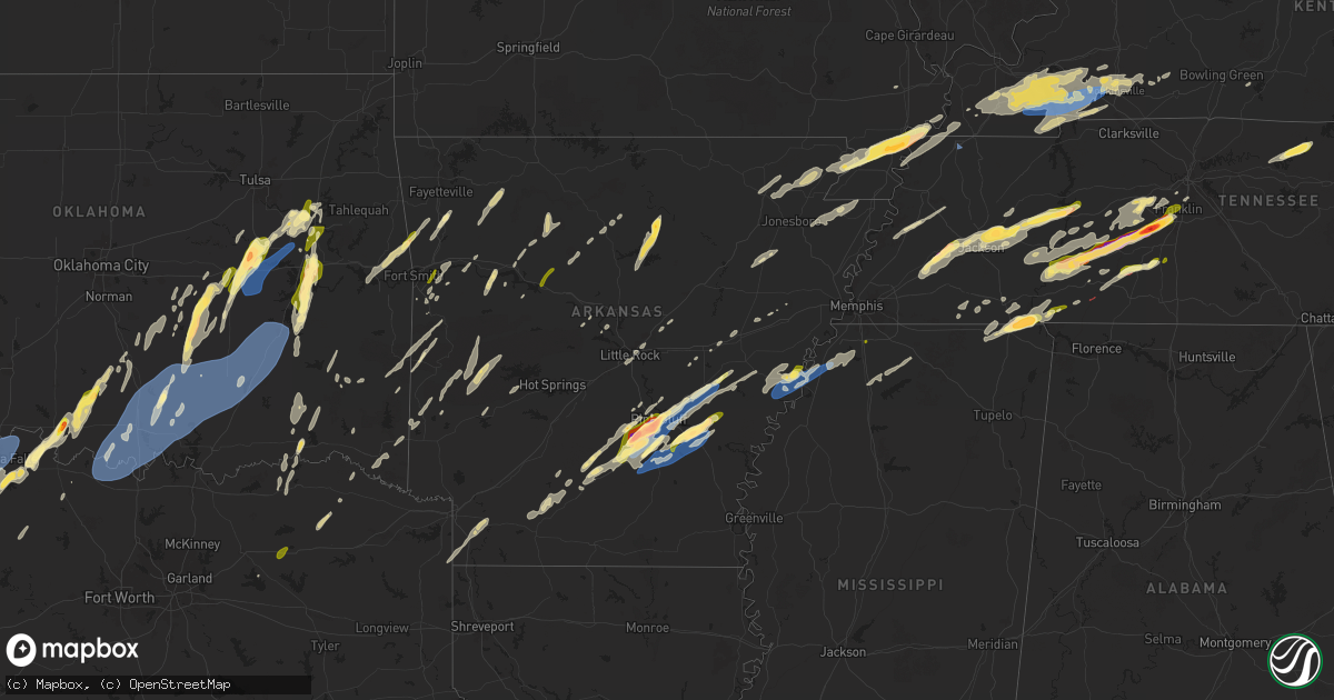
Hail Map in Arkansas on April 3, 2025
Get this storm
April 3 map
$229
one time, instant access
Download today. No call, no setup
Keep the $229
Bought the map and want the full workflow? Apply the entire $229 to a subscription within 7 days. None of it is wasted.
Every map, not just this one
This buys you this map. Subscription and you get every map we run, in the markets you choose from a few cities to whole states to nationwide. Plus real-time alerts the moment a storm fires.
Contact data
Name, contact info, occupancy, even credit band for addresses in the footprint. You go from where it hit to who to call.
Become the source they trust
Unlimited branding weather history reports on demand. You already have the documented answer ready for the property owner, and you are the one who showed up with it.
Property data and RoofTrace estimates
Pull up any address you have got, its value and the exact code rules for that jurisdiction, straight from One Click Code. Then RoofTrace estimates the squares, pitch, and roof value, priced the way you price.
Storm reports in Arkansas
Arkansas
| Date | Description |
|---|---|
| 04/03/20256:26 PM CDT | Tree blown onto a house in fordyce. |
| 04/03/20256:16 PM CDT | Trees and powerlines reported blown down along calhoun 68. |
| 04/03/20255:56 PM CDT | Highway 242 and hwy 44 area. Shop blown over and trucks overturned in lot. |
| 04/03/20254:53 PM CDT | Outbuilding destroyed and contents blown into an adjacent field. Verified through pictures on social media. |
| 04/03/20254:49 PM CDT | A local report indicates 60 MPH wind near 2 S South Stuttgart |
| 04/03/20254:08 PM CDT | A local report indicates 1.00 inch wind near 2 S Pine Bluff |
| 04/03/20254:06 PM CDT | A local report indicates 1.00 inch wind near 2 E Sorrells |
| 04/03/20254:04 PM CDT | Trees and powerlines blown down. |
| 04/03/20254:02 PM CDT | A local report indicates 2.50 inch wind near Watson Chapel |
| 04/03/20254:02 PM CDT | A local report indicates 2.00 inch wind near 1 W Watson Chapel |
| 04/03/20254:02 PM CDT | Report via social media. |
| 04/03/20253:51 PM CDT | Report via social media. |
| 04/03/20253:23 PM CDT | Time estimated by radar. |
| 04/03/20253:15 PM CDT | Multiple tress down in and around rison. Reports of roof damage to buildings in town. |
| 04/03/20253:15 PM CDT | Numerous trees down in the kedron community. |
| 04/03/20253:10 PM CDT | Time estimated by radar. |
| 04/03/20252:38 PM CDT | Picture via social media. |
| 04/02/20257:13 PM CDT | Storm verified from pictures on social media and radar estimates. |
| 04/02/20257:04 PM CDT | Quarter sized hail in star city. Also some tin blown off the roof of a building near the courthouse. |
All States Impacted by Hail Map on April 3, 2025
Cities Impacted by Hail Map on April 3, 2025
- Sebewaing, MI
- Unionville, MI
- Bay Port, MI
- Pigeon, MI
- Jefferson, TX
- Linden, TX
- Bivins, TX
- Nashoba, OK
- Smithville, OK
- Honobia, OK
- Jacksboro, TX
- Bryson, TX
- Bowie, TX
- Pleasant Shade, TN
- Carthage, TN
- Nocona, TX
- Whitleyville, TN
- Gainesboro, TN
- Overbrook, OK
- Burneyville, OK
- Wilson, OK
- Leon, OK
- Celina, TN
- Hilham, TN
- Muenster, TX
- Saint Jo, TX
- Ringling, OK
- Lone Grove, OK
- Thackerville, OK
- Gainesville, TX
- Marietta, OK
- Ardmore, OK
- Springer, OK
- Madill, OK
- Davis, OK
- Dougherty, OK
- Sulphur, OK
- Mill Creek, OK
- Tishomingo, OK
- Mannsville, OK
- Lebanon, OK
- Whitesboro, TX
- Kingston, OK
- Roff, OK
- Kenefic, OK
- Milburn, OK
- Coleman, OK
- Atoka, OK
- Caddo, OK
- Wapanucka, OK
- Stonewall, OK
- Tupelo, OK
- Fitzhugh, OK
- Fittstown, OK
- Coalgate, OK
- Centrahoma, OK
- Allen, OK
- Stringtown, OK
- Wardville, OK
- Pittsburg, OK
- Kiowa, OK
- Mcalester, OK
- Stuart, OK
- Blanco, OK
- Savanna, OK
- Hartshorne, OK
- Krebs, OK
- Albany, KY
- Union City, TN
- De Queen, AR
- Scottsville, KY
- Smiths Grove, KY
- Mena, AR
- Brashear, TX
- Cumby, TX
- Sulphur Springs, TX
- Fairview, TN
- Franklin, TN
- Reagan, TN
- Enville, TN
- Waldron, AR
- Primm Springs, TN
- Columbia, TN
- Santa Fe, TN
- Thompsons Station, TN
- Lone Oak, TX
- Point, TX
- Bon Aqua, TN
- Clarksville, TX
- Sulphur Bluff, TX
- Scotts Hill, TN
- Lexington, TN
- Bogata, TX
- Talco, TX
- Sardis, TN
- Decaturville, TN
- Savannah, TN
- Clifton, TN
- Rousseau, KY
- Saltillo, TN
- Morris Chapel, TN
- Idabel, OK
- Bath Springs, TN
- Linden, TN
- Grannis, AR
- Eagletown, OK
- Waynesboro, TN
- Wickes, AR
- Hohenwald, TN
- Darden, TN
- Clarksville, AR
- Lamar, AR
- Umpire, AR
- Hagarville, AR
- Lavaca, AR
- Broken Bow, OK
- Vandervoort, AR
- Norman, AR
- Centerville, TN
- Parsons, TN
- Gillham, AR
- Clinton, AR
- Duck River, TN
- Belfry, KY
- Pilgrim, KY
- Williamsport, TN
- Williamson, WV
- Delbarton, WV
- Pikeville, KY
- Greenwood, AR
- Hampshire, TN
- Hector, AR
- Leslie, AR
- Dennard, AR
- Lyles, TN
- Lobelville, TN
- Dardanelle, AR
- Spring Hill, TN
- Kingsland, AR
- Rison, AR
- Pine Bluff, AR
- Alma, AR
- Dyer, AR
- Fordyce, AR
- Ivan, AR
- Witter, AR
- Huntsville, AR
- Bonnerdale, AR
- Salyersville, KY
- Grapevine, AR
- Manchester, KY
- Royal, AR
- Sextons Creek, KY
- Oil Springs, KY
- Dover, TN
- Stewart, TN
- Russellville, AR
- White Hall, AR
- Dover, AR
- Hackett, AR
- Charleston, AR
- Hornsby, TN
- West Liberty, KY
- Flatgap, KY
- Keaton, KY
- Nashville, TN
- Brentwood, TN
- Como, MS
- Mount Ida, AR
- Middleton, TN
- Atlanta, TX
- Doddridge, AR
- Bloomburg, TX
- Oneida, KY
- Huntington, AR
- Oden, AR
- Pencil Bluff, AR
- Annville, KY
- Fort Smith, AR
- Saulsbury, TN
- Bolivar, TN
- Perryville, AR
- Sims, AR
- Watson, OK
- Selmer, TN
- Pocahontas, TN
- Houston, AR
- Buckhorn, KY
- Mistletoe, KY
- Heavener, OK
- Hodgen, OK
- Fouke, AR
- Holly Springs, MS
- Senatobia, MS
- Kiahsville, WV
- Inez, KY
- Tomahawk, KY
- Guys, TN
- Ramer, TN
- Corinth, MS
- Dunlow, WV
- Genoa, WV
- Crum, WV
- Fort Gay, WV
- Louisa, KY
- Wilsondale, WV
- Warfield, KY
- Saint Paul, AR
- Chavies, KY
- Gays Creek, KY
- Krypton, KY
- Garland City, AR
- Debord, KY
- Beaver, WV
- Sherrill, AR
- Boons Camp, KY
- Meadow Bridge, WV
- Spring Dale, WV
- Grassy Meadows, WV
- Alderson, WV
- Smoot, WV
- Harts, WV
- Beauty, KY
- Ranger, WV
- Lewisville, AR
- Michie, TN
- Burnsville, MS
- Lovely, KY
- Kermit, WV
- Counce, TN
- Bethel Springs, TN
- Booneville, AR
- Iuka, MS
- Shiloh, TN
- Stantonville, TN
- Waldo, AR
- Altheimer, AR
- Wabbaseka, AR
- Lutts, TN
- Rosston, AR
- Collinwood, TN
- Stephens, AR
- McNeil, AR
- Walnut, MS
- Chidester, AR
- Camden, AR
- Lexa, AR
- West Helena, AR
- Helena, AR
- Poplar Grove, AR
- Marvell, AR
- Lawrenceburg, TN
- Bigelow, AR
- Nunnelly, TN
- Marianna, AR
- Summertown, TN
- Dundee, MS
- Bearden, AR
- Mount Pleasant, TN
- Culleoka, TN
- Lynnville, TN
- Burns, TN
- Ethridge, TN
- Dickson, TN
- Tunica, MS
- Walnut Ridge, AR
- O'Kean, AR
- Delaplaine, AR
- Waterloo, AL
- Glen, MS
- Hoxie, AR
- Coldwater, MS
- New Edinburg, AR
- Star City, AR
- Hernando, MS
- Yorktown, AR
- Grady, AR
- Gould, AR
- Stuttgart, AR
- De Witt, AR
- Almyra, AR
- Bono, AR
- Beech Grove, AR
- Pocahontas, AR
- Wilmar, AR
- Paragould, AR
- Lafe, AR
- Marmaduke, AR
- Little Rock, AR
- North Little Rock, AR
- Kennett, MO
- Rector, AR
- Humphrey, AR
- Piggott, AR
- Greenway, AR
- Stanton, TN
- Somerville, TN
- Whiteville, TN
- Brownsville, TN
- Mason, TN
- Jacksonville, AR
- Beebe, AR
- Ward, AR
- Holcomb, MO
- Gideon, MO
- Bragg City, MO
- Bells, TN
- Denmark, TN
- Austin, AR
- Cabot, AR
- Portageville, MO
- Wardell, MO
- Jackson, TN
- Medina, TN
- Holly Grove, AR
- Marston, MO
- Tiptonville, TN
- Hickman, KY
- Wildersville, TN
- Cedar Grove, TN
- Oakfield, TN
- Beech Bluff, TN
- Huron, TN
- Luray, TN
- De Valls Bluff, AR
- New Madrid, MO
- Yuma, TN
- Buena Vista, TN
- Westport, TN
- Holladay, TN
- Sugar Tree, TN
- Biscoe, AR
- Hornbeak, TN
- Ridgely, TN
- Troy, TN
- Brinkley, AR
- Waverly, TN
- Hurricane Mills, TN
- Fisher, AR
- East Prairie, MO
- Colt, AR
- Weiner, AR
- Hickory Ridge, AR
- Fulton, KY
- Wynne, AR
- Clinton, KY
- Mayfield, KY
- Fancy Farm, KY
- Hickory, KY
- Ozona, TX
- Sheffield, TX
- Cadiz, KY
- Murray, KY
- Lake City, AR
- Black Oak, AR
- Boaz, KY
- Monette, AR
- Caraway, AR
- Symsonia, KY
- Benton, KY
- Carthage, AR
- Sheridan, AR
- Leachville, AR
- Manila, AR
- Calvert City, KY
- Hardin, KY
- Kirksey, KY
- Almo, KY
- Iraan, TX
- Gilbertsville, KY
- Blytheville, AR
- Hopkinsville, KY
- Farmington, KY
- Grand Rivers, KY
- Kuttawa, KY
- Dexter, KY
- Elaine, AR
- Big Lake, TX
- Barnhart, TX
- Ripley, TN
- Henning, TN
- Eddyville, KY
- McCamey, TX
- Princeton, KY
- Gates, TN
- Gracey, KY
- Midkiff, TX
- Crane, TX
- Cerulean, KY
- Crofton, KY
- Nolan, TX
- Blackwell, TX
- Maryneal, TX
- Dryden, TX
- Colorado City, TX
- Merkel, TX
- Friendship, TN
- Halls, TN
- Roscoe, TX
- Sparkman, AR
- Loraine, TX
- Hermleigh, TX
- Elkton, KY
- Garden City, TX
- Sweetwater, TX
- Pembroke, KY
- Thornton, AR
- Huntingdon, TN
- Trent, TX
- Jacks Creek, TN
- Sharon Grove, KY
- Lewisburg, KY
- Comstock, TX
- Odessa, TX
- Bradford, TN
- Granville, TN
- Abilene, TX
- Sterling City, TX
- Sylvester, TX
- Anson, TX
- Hawley, TX
- Stamford, TX
- Casscoe, AR
- Crocketts Bluff, AR
- Lueders, TX
- Hamlin, TX
- Roe, AR
- Westbrook, TX
- Del Rio, TX
- Avoca, TX
- Sonora, TX
- Throckmorton, TX
- Mertzon, TX
- Midland, TX
- Clarendon, AR
- Robert Lee, TX
- Sikeston, MO
- Albany, TX
- Grandfalls, TX
- Rule, TX
- Aspermont, TX
- Jefferson, AR
- Haskell, TX
- New Concord, KY
- Hazel, KY
- Bumpus Mills, TN
- Coahoma, TX
- Big Spring, TX
- Ira, TX
- Snyder, TX
- Stanton, TX
- Olney, TX
- Herndon, KY
- Newcastle, TX
- La Fayette, KY
- Weinert, TX
- Weston, WV
- Walkersville, WV
- New Milton, WV
- Linn, WV
- Glenville, WV
- Burnsville, WV
- Troy, WV
- Camden, WV
- Harrisville, WV
- Auburn, WV
- Smithville, WV
- Orlando, WV
- Alum Bridge, WV
- Coxs Mills, WV
- Volga, WV
- Jane Lew, WV
- Buckhannon, WV
- Horner, WV
- Adrian, WV
- Philippi, WV
- Belington, WV
- Elkins, WV
- Ellamore, WV
- Kerens, WV
- Montrose, WV
- Parsons, WV
- Hendricks, WV
- Tallmansville, WV
- Coalton, WV
- Seymour, TX
- Holliday, TX
- McCaulley, TX
- Carlisle, AR
- Archer City, TX
- Scotland, TX
- Windthorst, TX
- Hazen, AR
- Hanover, PA
- West Grove, PA
- Coatesville, PA
- Glen Rock, PA
- New Freedom, PA
- Shrewsbury, PA
- Henrietta, TX
- Wichita Falls, TX
- Mayflower, AR
- Roland, AR
- Stewartstown, PA
- West Chester, PA
- Glen Mills, PA
- Thornton, PA
- Chadds Ford, PA
- New Park, PA
- Kennett Square, PA
- Waurika, OK
- Ryan, OK
- Petrolia, TX
- Wallingford, PA
- Brookhaven, PA
- Media, PA
- Chester, PA
- Crum Lynne, PA
- Woodlyn, PA
- Aston, PA
- Folsom, PA
- Swarthmore, PA
- Ridley Park, PA
- Chester Heights, PA
- Garnet Valley, PA
- Marcus Hook, PA
- Prospect Park, PA
- Morton, PA
- Springfield, PA
- Norwood, PA
- Glenolden, PA
- Essington, PA
- Folcroft, PA
- Holmes, PA
- Philadelphia, PA
- Gibbstown, NJ
- Thorofare, NJ
- Paulsboro, NJ
- National Park, NJ
- Westville, NJ
- Bellmawr, NJ
- Woodbury, NJ
- Runnemede, NJ
- Voorhees, NJ
- Quitman, AR
- Kirby, AR
- Somerdale, NJ
- Blackwood, NJ
- Woodbury Heights, NJ
- Glendora, NJ
- Clementon, NJ
- Magnolia, NJ
- Stratford, NJ
- Barrington, NJ
- Swedesboro, NJ
- Loco, OK
- Duncan, OK
- Electra, TX
- Iowa Park, TX
- Glenwood, AR
- Higden, AR
- Marlton, NJ
- Vincentown, NJ
- Medford, NJ
- Gibbsboro, NJ
- Cooper, TX
- Sheppard Afb, TX
- Ratliff City, OK
- Tussy, OK
- Cheyney, PA
- Gloucester City, NJ
- Bridgeport, NJ
- Haddon Heights, NJ
- Lawnside, NJ
- Mount Ephraim, NJ
- Haddonfield, NJ
- Sharon Hill, PA
- Clarksboro, NJ
- Sewell, NJ
- Mount Royal, NJ
- Wenonah, NJ
- Mickleton, NJ
- Mantua, NJ
- Pitman, NJ
- Mullica Hill, NJ
- Berlin, NJ
- Atco, NJ
- West Berlin, NJ
- Edgemont, AR
- Prim, AR
- Mountain View, AR
- Penns Grove, NJ
- Pedricktown, NJ
- Wilmington, DE
- Elmore City, OK
- Petty, TX
- Roxton, TX
- Drasco, AR
- Foster, OK
- Hennepin, OK
- Parks, AR
- Cherry Hill, NJ
- Hugo, OK
- Harvey, AR
- Woodstown, NJ
- Monroeville, NJ
- Valliant, OK
- Wynnewood, OK
- Brookston, TX
- Arthur City, TX
- Sumner, TX
- Ada, OK
- Powderly, TX
- Paris, TX
- Boswell, OK
- Wright City, OK
- Stratford, OK
- Pauls Valley, OK
- Varney, KY
- Grant, OK
- Rattan, OK
- Spencerville, OK
- Konawa, OK
- Sasakwa, OK
- Wewoka, OK
- Antlers, OK
- Asher, OK
- Wanette, OK
- Byars, OK
- Glassboro, NJ
- Paris, AR
- Finley, OK
- Snow, OK
- Subiaco, AR
- Scranton, AR
- Atwood, OK
- Holdenville, OK
- Sallisaw, OK
- Keota, OK
- Maud, OK
- Hartman, AR
- Gans, OK
- Muldrow, OK
- Wetumka, OK
- Seminole, OK
- Winslow, AR
- Okemah, OK
- Weleetka, OK
- Henryetta, OK
- Haileyville, OK
- Chester, AR
- Mountainburg, AR
- Mount Judea, AR
- Pelsor, AR
- Calvin, OK
- Okmulgee, OK
- Natural Dam, AR
- Uniontown, AR
- Stilwell, OK
- Earlsboro, OK
- Eufaula, OK
- Quinton, OK
- Stigler, OK
- Talihina, OK
- Fayetteville, AR
- West Fork, AR
- Boynton, OK
- Morris, OK
- Haskell, OK
- Checotah, OK
- Prairie Grove, AR
- Porum, OK
- Porter, OK
- Wagoner, OK
- Muskogee, OK
- Oktaha, OK
- Mulberry, AR
- Ozark, AR
- Taft, OK
- Redbird, OK
- Coweta, OK
- Warner, OK
- Cecil, AR
- Canadian, OK
- Beggs, OK
- Dustin, OK
- Hanna, OK
- Council Hill, OK


