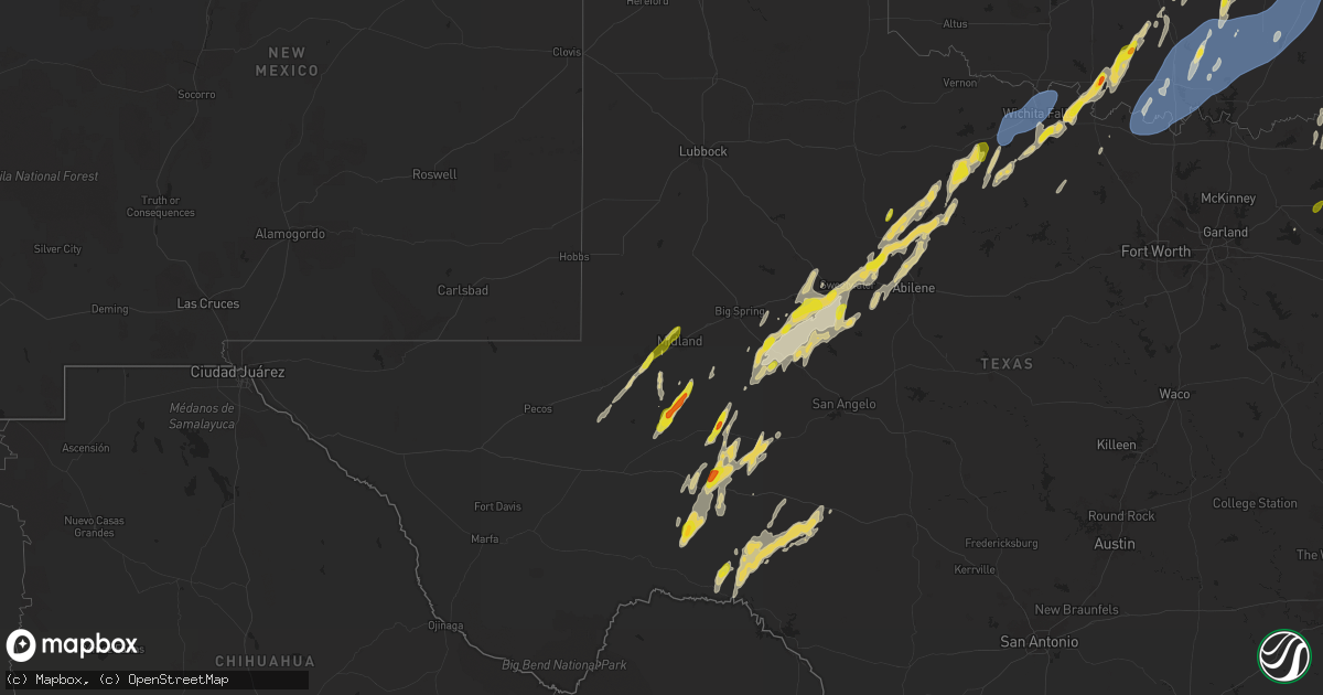
Hail Map on April 3, 2025
Get this storm
April 3 map
$229
one time, instant access
Download today. No call, no setup
Keep the $229
Bought the map and want the full workflow? Apply the entire $229 to a subscription within 7 days. None of it is wasted.
Every map, not just this one
This buys you this map. Subscription and you get every map we run, in the markets you choose from a few cities to whole states to nationwide. Plus real-time alerts the moment a storm fires.
Contact data
Name, contact info, occupancy, even credit band for addresses in the footprint. You go from where it hit to who to call.
Become the source they trust
Unlimited branding weather history reports on demand. You already have the documented answer ready for the property owner, and you are the one who showed up with it.
Property data and RoofTrace estimates
Pull up any address you have got, its value and the exact code rules for that jurisdiction, straight from One Click Code. Then RoofTrace estimates the squares, pitch, and roof value, priced the way you price.
States Impacted by Hail Map on April 3, 2025
Storm reports
Texas
| Date | Description |
|---|---|
| 04/03/20251:11 PM CDT | Quarter size hail reported on cr 1157. |
| 04/03/20253:56 AM CDT | A local report indicates 62 MPH wind near 3 NW Lakeside City |
| 04/03/20252:58 AM CDT | Report from mping: quarter |
| 04/03/20252:37 AM CDT | Public phone call of nickel to quarter size hail near odessa high school. |
| 04/03/20252:32 AM CDT | Received phone call from a spotter of quarter size hail on the west side of odessa. Time and location are estimated. |
Missouri
| Date | Description |
|---|---|
| 04/02/20258:40 PM CDT | Ping pong ball sized hail near portageville. |
| 04/02/20258:37 PM CDT | A local report indicates 1.50 inch wind near Portageville |
Mississippi
| Date | Description |
|---|---|
| 04/03/20254:51 PM CDT | 2 inch hail reported east of corinth. |
| 04/03/20254:20 PM CDT | Tree down blocking the teckville boat ramp. |
| 04/02/20257:06 PM CDT | Jaybird road and byhalia road. |
Pennsylvania
| Date | Description |
|---|---|
| 04/03/20254:00 AM CDT | Report from mping: quarter |
| 04/03/20254:00 AM CDT | Weather observer at kphl reported 1 inch hail. |
| 04/03/20253:54 AM CDT | Multiple tree limbs down. |
| 04/03/20253:54 AM CDT | Quarter sized hail. |
| 04/03/20253:50 AM CDT | Several trunks of large trees snapped. |
| 04/03/20253:50 AM CDT | Multiple trees uprooted and snapped. Time estimated from radar. |
| 04/03/20253:50 AM CDT | Tree uprooted. Time estimated from radar. |
| 04/03/20253:50 AM CDT | Roof damage. Time estimated from radar. |
| 04/03/20253:47 AM CDT | Also estimated 65 mph wind gusts. |
| 04/03/20253:45 AM CDT | Multiple trees and wires down. Time estimated from radar. |
| 04/03/20253:45 AM CDT | Scattered trees down. Time estimated from radar. |
| 04/03/20253:45 AM CDT | Multiple large trees snapped. Time estimated from radar. |
| 04/03/20253:44 AM CDT | Tree down blocking a lane on 476 south bound. Time estimated from radar. |
West Virginia
| Date | Description |
|---|---|
| 04/03/20255:08 PM CDT | Thunderstorm winds blew down one large tree at the intersection of bungers mill road and herns mill road. |
| 04/03/20254:33 PM CDT | Tree down blocking most of stone coal rd. Between kiah creek rd. And twelvepole creek rd. Time estimated from radar. |
| 04/03/20254:27 PM CDT | Asos station kbkw beckley airport. |
| 04/03/20254:27 PM CDT | Lines down in 3000 block of robert c. Byrd dr. Time estimated from radar and nearby asos. |
| 04/03/20254:26 PM CDT | Tree down in 100 block of high school dr. Near vo tech dr. Time estimated from radar and nearby asos. |
| 04/03/20254:09 PM CDT | Tree and power lines down on coal river rd. Near bolt rd. Time estimated from radar. |
| 04/03/20253:24 PM CDT | Power lines in the road between crystal block and hatfield cemetery. Time estimated from radar. |
| 04/03/202510:00 AM CDT | Tree down on power lines. Time estimated by radar. |
| 04/03/20259:30 AM CDT | Tree down on power lines. Time estimated by radar. |
| 04/03/20257:15 AM CDT | Tree down on power lines. Time estimated by radar. |
| 04/03/20257:00 AM CDT | Large tree down between po road and river church road. |
| 04/03/20254:05 AM CDT | A tree blew down near the dollar general along daniel boone parkway. |
| 04/03/20253:25 AM CDT | 4 to 5 large trees down on property in 2400 block of middle cove road. |
| 04/03/20252:19 AM CDT | A local report indicates 58 MPH wind near Philippi |
| 04/03/20252:09 AM CDT | Tree down onto pringle tree park road north of buckhannon. Time estimated via radar. |
| 04/03/20252:09 AM CDT | Power line down along serviceberry lane. |
New Jersey
| Date | Description |
|---|---|
| 04/03/20255:04 AM CDT | Report from mping: quarter |
| 04/03/20254:35 AM CDT | Tree damage and a large field irrigation system toppled over. Time estimated from radar. |
| 04/03/20254:15 AM CDT | Multiple trees and wires down. Time estimated from radar. |
| 04/03/20254:15 AM CDT | Multiple trees and wires down. Time estimated from radar. |
| 04/03/20254:15 AM CDT | Trees down. Time estimated from radar. |
| 04/03/20254:12 AM CDT | Multiple trees down in broadmoor neighborhood. |
| 04/03/20254:10 AM CDT | A local report indicates 1.00 inch wind near Blackwood |
| 04/03/20254:06 AM CDT | Several trees uprooted... Trunks snapped... And fences down near timber creek park. Time estimated by radar. |
| 04/03/20254:05 AM CDT | Tree blown down on to a vehicle. Time estimated from radar. |
| 04/03/20254:05 AM CDT | Several trees downed and trunks snapped. Time estimated by radar. |
| 04/03/20254:05 AM CDT | Multiple trees down... A fence destroyed... And a window broken. Time estimated from radar. |
| 04/03/20254:00 AM CDT | Partial structural collapse from a tree falling into a building. Time estimated from radar. |
| 04/03/20254:00 AM CDT | Multiple trees and wires down. Time estimated from radar. |
Tennessee
| Date | Description |
|---|---|
| 04/03/20256:06 PM CDT | Possible tornado. Em reports tree down across chief creek road. Power flashes and power outages also reported. Time estimated via radar. |
| 04/03/20255:22 PM CDT | Possible tornado. Multiple trees down along king branch road and jones hollow road south of lobelville. Tree on king branch road fell onto a home... Causing significant |
| 04/03/20255:09 PM CDT | Multiple trees down on morris road in walnut grove. This area was under a tornado warning at this time as well so may need to further evaluate. |
| 04/03/20255:01 PM CDT | Multiple homes with roof damage on arnold lane. |
| 04/03/20254:42 PM CDT | Several reports of quarter to half dollar size hail. Time and location estimated via radar. |
| 04/03/20254:00 PM CDT | Time estimated via radar. |
| 04/03/20253:36 PM CDT | Theta... Tn chestnut ridge rd. Time estimated via radar/. |
| 04/03/20253:35 PM CDT | Report of hail at hilltown rd and fly road. |
| 04/03/20253:30 PM CDT | Picture of larger than tea cup size hail. Time estimated from radar. |
| 04/03/20253:30 PM CDT | Water valley rd and highway 7 near santa fe. |
| 04/03/20253:30 PM CDT | A local report indicates 1.25 inch wind near Williamsport |
| 04/03/20253:24 PM CDT | Time estimated via radar. |
| 04/03/20252:54 PM CDT | A local report indicates 1.00 inch wind near Hohenwald |
| 04/03/20252:48 PM CDT | Report of large hail on the perry/lewis county line on highway 412. Time estimated via radar. |
| 04/03/20252:12 PM CDT | Trees down on a power line. |
| 04/03/20259:38 AM CDT | Thunderstorm wind damage report of trees down and roof damage along flatwoods road and cedars of lebanon state park |
| 04/03/20257:45 AM CDT | South harpeth rd between pinewood rd and i-840 closed because of high water. |
| 04/03/20257:12 AM CDT | Trees down. |
| 04/02/20259:25 PM CDT | Near interstate 40. |
| 04/02/20258:49 PM CDT | A local report indicates 1.75 inch wind near Spring Creek |
| 04/02/20258:40 PM CDT | Large trees down on riverside dr. |
Arkansas
| Date | Description |
|---|---|
| 04/03/20256:26 PM CDT | Tree blown onto a house in fordyce. |
| 04/03/20256:16 PM CDT | Trees and powerlines reported blown down along calhoun 68. |
| 04/03/20255:56 PM CDT | Highway 242 and hwy 44 area. Shop blown over and trucks overturned in lot. |
| 04/03/20254:53 PM CDT | Outbuilding destroyed and contents blown into an adjacent field. Verified through pictures on social media. |
| 04/03/20254:49 PM CDT | A local report indicates 60 MPH wind near 2 S South Stuttgart |
| 04/03/20254:08 PM CDT | A local report indicates 1.00 inch wind near 2 S Pine Bluff |
| 04/03/20254:06 PM CDT | A local report indicates 1.00 inch wind near 2 E Sorrells |
| 04/03/20254:04 PM CDT | Trees and powerlines blown down. |
| 04/03/20254:02 PM CDT | Report via social media. |
| 04/03/20254:02 PM CDT | A local report indicates 2.00 inch wind near 1 W Watson Chapel |
| 04/03/20254:02 PM CDT | A local report indicates 2.50 inch wind near Watson Chapel |
| 04/03/20253:51 PM CDT | Report via social media. |
| 04/03/20253:23 PM CDT | Time estimated by radar. |
| 04/03/20253:15 PM CDT | Multiple tress down in and around rison. Reports of roof damage to buildings in town. |
| 04/03/20253:15 PM CDT | Numerous trees down in the kedron community. |
| 04/03/20253:10 PM CDT | Time estimated by radar. |
| 04/03/20252:38 PM CDT | Picture via social media. |
| 04/02/20257:13 PM CDT | Storm verified from pictures on social media and radar estimates. |
| 04/02/20257:04 PM CDT | Quarter sized hail in star city. Also some tin blown off the roof of a building near the courthouse. |
Oklahoma
| Date | Description |
|---|---|
| 04/03/20258:38 AM CDT | Several trees down. Time estimated from radar. |
| 04/03/20258:35 AM CDT | 12 inch tree down. |
| 04/03/20258:35 AM CDT | Large tree down with snapped transformer pole on s. Dexter and main st. |
| 04/03/20258:29 AM CDT | A local report indicates 68 MPH wind near 1.5 N Springer |
| 04/03/20258:25 AM CDT | A local report indicates 63 MPH wind near 5 NNW Lebanon |
| 04/03/20258:10 AM CDT | A local report indicates 72 MPH wind near Burneyville |
| 04/03/20258:05 AM CDT | Several trees down. |
| 04/03/20258:05 AM CDT | Tree down on melvin douglast... 1 mile north of enville-ran rd. Picture in slack. |
| 04/03/20258:05 AM CDT | Trees and power lines down in oakland. |
| 04/03/20258:05 AM CDT | Power lines down blocking roadway at hwy 77 and indian trails. Time estimated from radar. |
| 04/03/20258:04 AM CDT | 30 inch tree blocking roadway on vinson rd. |
| 04/03/20258:04 AM CDT | Power pole down... Wire on tree. Time estimated from radar. |
| 04/03/20257:15 AM CDT | Semi blown over on i-35 at mile marker 18. |
| 04/03/20256:58 AM CDT | A local report indicates 1.50 inch wind near 5 WSW Warner |
| 04/03/20256:40 AM CDT | A local report indicates 1.75 inch wind near 5 NE Eufaula |
| 04/03/20256:38 AM CDT | Report from mping: golf ball |
| 04/03/20256:35 AM CDT | Location and time estimated from radar. Photo of hail seen on local broadcast media. |
| 04/03/20256:12 AM CDT | Report from mping: quarter |
| 04/03/20256:10 AM CDT | Trained spotter reported thunderstorm wind gust of 60 mph around 9th and gentry st. In henryetta. Report relayed by emergency management. |
| 04/03/20255:45 AM CDT | A local report indicates 1.75 inch wind near 4 ENE Wewoka |
| 04/03/20255:45 AM CDT | Time estimated from radar. |
| 04/03/20255:26 AM CDT | Report from mping: quarter |
| 04/03/20255:24 AM CDT | Report from mping: quarter |
| 04/03/20255:13 AM CDT | Report from mping: quarter |
Kentucky
| Date | Description |
|---|---|
| 04/03/20253:22 PM CDT | Rockcastle 911 center reported several trees down on south wilderness road... 2 miles south of livingston near the laurel county line. Time estimated from radar. |
| 04/03/20256:01 AM CDT | Reported multiple trees down between middlesburg and yosemite from storms this morning. 2 barns heavily damaged and roof torn off part of house. Two storms on radar had |
| 04/03/202512:13 AM CDT | Three power poles were damaged on canton pike between pyle lane and eagle way bypass in hopkinsville. The road remains closed. Time estimated from radar. |
| 04/02/202510:50 PM CDT | Trees down on hwy 280 near calloway county east elementary school. |
Cities Impacted by Hail Map on April 3, 2025
- Sebewaing, MI
- Unionville, MI
- Bay Port, MI
- Pigeon, MI
- Jefferson, TX
- Linden, TX
- Bivins, TX
- Nashoba, OK
- Smithville, OK
- Honobia, OK
- Jacksboro, TX
- Bryson, TX
- Bowie, TX
- Pleasant Shade, TN
- Carthage, TN
- Nocona, TX
- Whitleyville, TN
- Gainesboro, TN
- Overbrook, OK
- Burneyville, OK
- Wilson, OK
- Leon, OK
- Celina, TN
- Hilham, TN
- Muenster, TX
- Saint Jo, TX
- Ringling, OK
- Lone Grove, OK
- Thackerville, OK
- Gainesville, TX
- Marietta, OK
- Ardmore, OK
- Springer, OK
- Madill, OK
- Davis, OK
- Dougherty, OK
- Sulphur, OK
- Mill Creek, OK
- Tishomingo, OK
- Mannsville, OK
- Lebanon, OK
- Whitesboro, TX
- Kingston, OK
- Roff, OK
- Kenefic, OK
- Milburn, OK
- Coleman, OK
- Atoka, OK
- Caddo, OK
- Wapanucka, OK
- Stonewall, OK
- Tupelo, OK
- Fitzhugh, OK
- Fittstown, OK
- Coalgate, OK
- Centrahoma, OK
- Allen, OK
- Stringtown, OK
- Wardville, OK
- Pittsburg, OK
- Kiowa, OK
- Mcalester, OK
- Stuart, OK
- Blanco, OK
- Savanna, OK
- Hartshorne, OK
- Krebs, OK
- Albany, KY
- Union City, TN
- De Queen, AR
- Scottsville, KY
- Smiths Grove, KY
- Mena, AR
- Brashear, TX
- Cumby, TX
- Sulphur Springs, TX
- Fairview, TN
- Franklin, TN
- Reagan, TN
- Enville, TN
- Waldron, AR
- Primm Springs, TN
- Columbia, TN
- Santa Fe, TN
- Thompsons Station, TN
- Lone Oak, TX
- Point, TX
- Bon Aqua, TN
- Clarksville, TX
- Sulphur Bluff, TX
- Scotts Hill, TN
- Lexington, TN
- Bogata, TX
- Talco, TX
- Sardis, TN
- Decaturville, TN
- Savannah, TN
- Clifton, TN
- Rousseau, KY
- Saltillo, TN
- Morris Chapel, TN
- Idabel, OK
- Bath Springs, TN
- Linden, TN
- Grannis, AR
- Eagletown, OK
- Waynesboro, TN
- Wickes, AR
- Hohenwald, TN
- Darden, TN
- Clarksville, AR
- Lamar, AR
- Umpire, AR
- Hagarville, AR
- Lavaca, AR
- Broken Bow, OK
- Vandervoort, AR
- Norman, AR
- Centerville, TN
- Parsons, TN
- Gillham, AR
- Clinton, AR
- Duck River, TN
- Belfry, KY
- Pilgrim, KY
- Williamsport, TN
- Williamson, WV
- Delbarton, WV
- Pikeville, KY
- Greenwood, AR
- Hampshire, TN
- Hector, AR
- Leslie, AR
- Dennard, AR
- Lyles, TN
- Lobelville, TN
- Dardanelle, AR
- Spring Hill, TN
- Kingsland, AR
- Rison, AR
- Pine Bluff, AR
- Alma, AR
- Dyer, AR
- Fordyce, AR
- Ivan, AR
- Witter, AR
- Huntsville, AR
- Bonnerdale, AR
- Salyersville, KY
- Grapevine, AR
- Manchester, KY
- Royal, AR
- Sextons Creek, KY
- Oil Springs, KY
- Dover, TN
- Stewart, TN
- Russellville, AR
- White Hall, AR
- Dover, AR
- Hackett, AR
- Charleston, AR
- Hornsby, TN
- West Liberty, KY
- Flatgap, KY
- Keaton, KY
- Nashville, TN
- Brentwood, TN
- Como, MS
- Mount Ida, AR
- Middleton, TN
- Atlanta, TX
- Doddridge, AR
- Bloomburg, TX
- Oneida, KY
- Huntington, AR
- Oden, AR
- Pencil Bluff, AR
- Annville, KY
- Fort Smith, AR
- Saulsbury, TN
- Bolivar, TN
- Perryville, AR
- Sims, AR
- Watson, OK
- Selmer, TN
- Pocahontas, TN
- Houston, AR
- Buckhorn, KY
- Mistletoe, KY
- Heavener, OK
- Hodgen, OK
- Fouke, AR
- Holly Springs, MS
- Senatobia, MS
- Kiahsville, WV
- Inez, KY
- Tomahawk, KY
- Guys, TN
- Ramer, TN
- Corinth, MS
- Dunlow, WV
- Genoa, WV
- Crum, WV
- Fort Gay, WV
- Louisa, KY
- Wilsondale, WV
- Warfield, KY
- Saint Paul, AR
- Chavies, KY
- Gays Creek, KY
- Krypton, KY
- Garland City, AR
- Debord, KY
- Beaver, WV
- Sherrill, AR
- Boons Camp, KY
- Meadow Bridge, WV
- Spring Dale, WV
- Grassy Meadows, WV
- Alderson, WV
- Smoot, WV
- Harts, WV
- Beauty, KY
- Ranger, WV
- Lewisville, AR
- Michie, TN
- Burnsville, MS
- Lovely, KY
- Kermit, WV
- Counce, TN
- Bethel Springs, TN
- Booneville, AR
- Iuka, MS
- Shiloh, TN
- Stantonville, TN
- Waldo, AR
- Altheimer, AR
- Wabbaseka, AR
- Lutts, TN
- Rosston, AR
- Collinwood, TN
- Stephens, AR
- McNeil, AR
- Walnut, MS
- Chidester, AR
- Camden, AR
- Lexa, AR
- West Helena, AR
- Helena, AR
- Poplar Grove, AR
- Marvell, AR
- Lawrenceburg, TN
- Bigelow, AR
- Nunnelly, TN
- Marianna, AR
- Summertown, TN
- Dundee, MS
- Bearden, AR
- Mount Pleasant, TN
- Culleoka, TN
- Lynnville, TN
- Burns, TN
- Ethridge, TN
- Dickson, TN
- Tunica, MS
- Walnut Ridge, AR
- O'Kean, AR
- Delaplaine, AR
- Waterloo, AL
- Glen, MS
- Hoxie, AR
- Coldwater, MS
- New Edinburg, AR
- Star City, AR
- Hernando, MS
- Yorktown, AR
- Grady, AR
- Gould, AR
- Stuttgart, AR
- De Witt, AR
- Almyra, AR
- Bono, AR
- Beech Grove, AR
- Pocahontas, AR
- Wilmar, AR
- Paragould, AR
- Lafe, AR
- Marmaduke, AR
- Little Rock, AR
- North Little Rock, AR
- Kennett, MO
- Rector, AR
- Humphrey, AR
- Piggott, AR
- Greenway, AR
- Stanton, TN
- Somerville, TN
- Whiteville, TN
- Brownsville, TN
- Mason, TN
- Jacksonville, AR
- Beebe, AR
- Ward, AR
- Holcomb, MO
- Gideon, MO
- Bragg City, MO
- Bells, TN
- Denmark, TN
- Austin, AR
- Cabot, AR
- Portageville, MO
- Wardell, MO
- Jackson, TN
- Medina, TN
- Holly Grove, AR
- Marston, MO
- Tiptonville, TN
- Hickman, KY
- Wildersville, TN
- Cedar Grove, TN
- Oakfield, TN
- Beech Bluff, TN
- Huron, TN
- Luray, TN
- De Valls Bluff, AR
- New Madrid, MO
- Yuma, TN
- Buena Vista, TN
- Westport, TN
- Holladay, TN
- Sugar Tree, TN
- Biscoe, AR
- Hornbeak, TN
- Ridgely, TN
- Troy, TN
- Brinkley, AR
- Waverly, TN
- Hurricane Mills, TN
- Fisher, AR
- East Prairie, MO
- Colt, AR
- Weiner, AR
- Hickory Ridge, AR
- Fulton, KY
- Wynne, AR
- Clinton, KY
- Mayfield, KY
- Fancy Farm, KY
- Hickory, KY
- Ozona, TX
- Sheffield, TX
- Cadiz, KY
- Murray, KY
- Lake City, AR
- Black Oak, AR
- Boaz, KY
- Monette, AR
- Caraway, AR
- Symsonia, KY
- Benton, KY
- Carthage, AR
- Sheridan, AR
- Leachville, AR
- Manila, AR
- Calvert City, KY
- Hardin, KY
- Kirksey, KY
- Almo, KY
- Iraan, TX
- Gilbertsville, KY
- Blytheville, AR
- Hopkinsville, KY
- Farmington, KY
- Grand Rivers, KY
- Kuttawa, KY
- Dexter, KY
- Elaine, AR
- Big Lake, TX
- Barnhart, TX
- Ripley, TN
- Henning, TN
- Eddyville, KY
- McCamey, TX
- Princeton, KY
- Gates, TN
- Gracey, KY
- Midkiff, TX
- Crane, TX
- Cerulean, KY
- Crofton, KY
- Nolan, TX
- Blackwell, TX
- Maryneal, TX
- Dryden, TX
- Colorado City, TX
- Merkel, TX
- Friendship, TN
- Halls, TN
- Roscoe, TX
- Sparkman, AR
- Loraine, TX
- Hermleigh, TX
- Elkton, KY
- Garden City, TX
- Sweetwater, TX
- Pembroke, KY
- Thornton, AR
- Huntingdon, TN
- Trent, TX
- Jacks Creek, TN
- Sharon Grove, KY
- Lewisburg, KY
- Comstock, TX
- Odessa, TX
- Bradford, TN
- Granville, TN
- Abilene, TX
- Sterling City, TX
- Sylvester, TX
- Anson, TX
- Hawley, TX
- Stamford, TX
- Casscoe, AR
- Crocketts Bluff, AR
- Lueders, TX
- Hamlin, TX
- Roe, AR
- Westbrook, TX
- Del Rio, TX
- Avoca, TX
- Sonora, TX
- Throckmorton, TX
- Mertzon, TX
- Midland, TX
- Clarendon, AR
- Robert Lee, TX
- Sikeston, MO
- Albany, TX
- Grandfalls, TX
- Rule, TX
- Aspermont, TX
- Jefferson, AR
- Haskell, TX
- New Concord, KY
- Hazel, KY
- Bumpus Mills, TN
- Coahoma, TX
- Big Spring, TX
- Ira, TX
- Snyder, TX
- Stanton, TX
- Olney, TX
- Herndon, KY
- Newcastle, TX
- La Fayette, KY
- Weinert, TX
- Weston, WV
- Walkersville, WV
- New Milton, WV
- Linn, WV
- Glenville, WV
- Burnsville, WV
- Troy, WV
- Camden, WV
- Harrisville, WV
- Auburn, WV
- Smithville, WV
- Orlando, WV
- Alum Bridge, WV
- Coxs Mills, WV
- Volga, WV
- Jane Lew, WV
- Buckhannon, WV
- Horner, WV
- Adrian, WV
- Philippi, WV
- Belington, WV
- Elkins, WV
- Ellamore, WV
- Kerens, WV
- Montrose, WV
- Parsons, WV
- Hendricks, WV
- Tallmansville, WV
- Coalton, WV
- Seymour, TX
- Holliday, TX
- McCaulley, TX
- Carlisle, AR
- Archer City, TX
- Scotland, TX
- Windthorst, TX
- Hazen, AR
- Hanover, PA
- West Grove, PA
- Coatesville, PA
- Glen Rock, PA
- New Freedom, PA
- Shrewsbury, PA
- Henrietta, TX
- Wichita Falls, TX
- Mayflower, AR
- Roland, AR
- Stewartstown, PA
- West Chester, PA
- Glen Mills, PA
- Thornton, PA
- Chadds Ford, PA
- New Park, PA
- Kennett Square, PA
- Waurika, OK
- Ryan, OK
- Petrolia, TX
- Wallingford, PA
- Brookhaven, PA
- Media, PA
- Chester, PA
- Crum Lynne, PA
- Woodlyn, PA
- Aston, PA
- Folsom, PA
- Swarthmore, PA
- Ridley Park, PA
- Chester Heights, PA
- Garnet Valley, PA
- Marcus Hook, PA
- Prospect Park, PA
- Morton, PA
- Springfield, PA
- Norwood, PA
- Glenolden, PA
- Essington, PA
- Folcroft, PA
- Holmes, PA
- Philadelphia, PA
- Gibbstown, NJ
- Thorofare, NJ
- Paulsboro, NJ
- National Park, NJ
- Westville, NJ
- Bellmawr, NJ
- Woodbury, NJ
- Runnemede, NJ
- Voorhees, NJ
- Quitman, AR
- Kirby, AR
- Somerdale, NJ
- Blackwood, NJ
- Woodbury Heights, NJ
- Glendora, NJ
- Clementon, NJ
- Magnolia, NJ
- Stratford, NJ
- Barrington, NJ
- Swedesboro, NJ
- Loco, OK
- Duncan, OK
- Electra, TX
- Iowa Park, TX
- Glenwood, AR
- Higden, AR
- Marlton, NJ
- Vincentown, NJ
- Medford, NJ
- Gibbsboro, NJ
- Cooper, TX
- Sheppard Afb, TX
- Ratliff City, OK
- Tussy, OK
- Cheyney, PA
- Gloucester City, NJ
- Bridgeport, NJ
- Haddon Heights, NJ
- Lawnside, NJ
- Mount Ephraim, NJ
- Haddonfield, NJ
- Sharon Hill, PA
- Clarksboro, NJ
- Sewell, NJ
- Mount Royal, NJ
- Wenonah, NJ
- Mickleton, NJ
- Mantua, NJ
- Pitman, NJ
- Mullica Hill, NJ
- Berlin, NJ
- Atco, NJ
- West Berlin, NJ
- Edgemont, AR
- Prim, AR
- Mountain View, AR
- Penns Grove, NJ
- Pedricktown, NJ
- Wilmington, DE
- Elmore City, OK
- Petty, TX
- Roxton, TX
- Drasco, AR
- Foster, OK
- Hennepin, OK
- Parks, AR
- Cherry Hill, NJ
- Hugo, OK
- Harvey, AR
- Woodstown, NJ
- Monroeville, NJ
- Valliant, OK
- Wynnewood, OK
- Brookston, TX
- Arthur City, TX
- Sumner, TX
- Ada, OK
- Powderly, TX
- Paris, TX
- Boswell, OK
- Wright City, OK
- Stratford, OK
- Pauls Valley, OK
- Varney, KY
- Grant, OK
- Rattan, OK
- Spencerville, OK
- Konawa, OK
- Sasakwa, OK
- Wewoka, OK
- Antlers, OK
- Asher, OK
- Wanette, OK
- Byars, OK
- Glassboro, NJ
- Paris, AR
- Finley, OK
- Snow, OK
- Subiaco, AR
- Scranton, AR
- Atwood, OK
- Holdenville, OK
- Sallisaw, OK
- Keota, OK
- Maud, OK
- Hartman, AR
- Gans, OK
- Muldrow, OK
- Wetumka, OK
- Seminole, OK
- Winslow, AR
- Okemah, OK
- Weleetka, OK
- Henryetta, OK
- Haileyville, OK
- Chester, AR
- Mountainburg, AR
- Mount Judea, AR
- Pelsor, AR
- Calvin, OK
- Okmulgee, OK
- Natural Dam, AR
- Uniontown, AR
- Stilwell, OK
- Earlsboro, OK
- Eufaula, OK
- Quinton, OK
- Stigler, OK
- Talihina, OK
- Fayetteville, AR
- West Fork, AR
- Boynton, OK
- Morris, OK
- Haskell, OK
- Checotah, OK
- Prairie Grove, AR
- Porum, OK
- Porter, OK
- Wagoner, OK
- Muskogee, OK
- Oktaha, OK
- Mulberry, AR
- Ozark, AR
- Taft, OK
- Redbird, OK
- Coweta, OK
- Warner, OK
- Cecil, AR
- Canadian, OK
- Beggs, OK
- Dustin, OK
- Hanna, OK
- Council Hill, OK