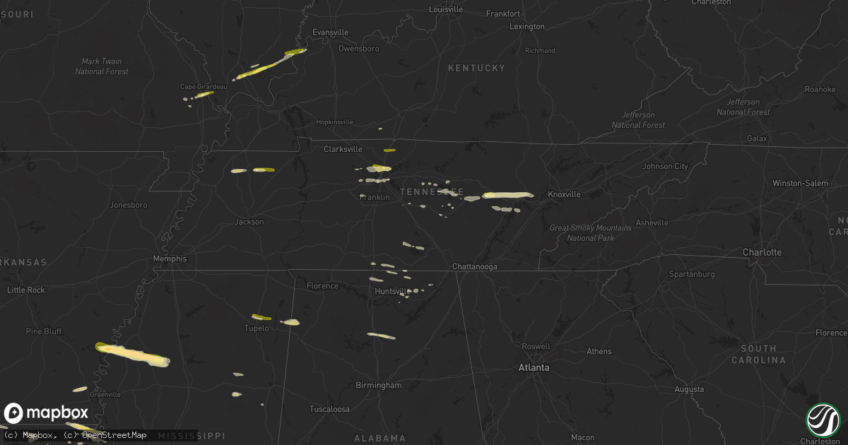
Hail Map in Tennessee on April 3, 2015
Get this storm
April 3 map
$229
one time, instant access
Download today. No call, no setup
Keep the $229
Bought the map and want the full workflow? Apply the entire $229 to a subscription within 7 days. None of it is wasted.
Every map, not just this one
This buys you this map. Subscription and you get every map we run, in the markets you choose from a few cities to whole states to nationwide. Plus real-time alerts the moment a storm fires.
Contact data
Name, contact info, occupancy, even credit band for addresses in the footprint. You go from where it hit to who to call.
Become the source they trust
Unlimited branding weather history reports on demand. You already have the documented answer ready for the property owner, and you are the one who showed up with it.
Property data and RoofTrace estimates
Pull up any address you have got, its value and the exact code rules for that jurisdiction, straight from One Click Code. Then RoofTrace estimates the squares, pitch, and roof value, priced the way you price.
Storm reports in Tennessee
Tennessee
| Date | Description |
|---|---|
| 04/03/20156:45 PM CDT | Public report of numerous trees and power lines down across the county. Possible but unconfirmed structure damage. |
| 04/03/20156:45 PM CDT | Trees down and damage to trailer in extreme southwest lawrence county |
| 04/03/20156:45 PM CDT | H and h auction building at 3897 sparta highway was destroyed |
| 04/03/20156:45 PM CDT | Several trees blown down on shady rest road |
| 04/03/20156:43 PM CDT | Camper flipped over and several large trees down on smithville highway |
| 04/03/20156:43 PM CDT | Shutters blown off a home on red road |
| 04/03/20156:42 PM CDT | Tree down on power line at us 43 and gale lane |
| 04/03/20156:42 PM CDT | A local report indicates 1.00 inch wind near OAKDALE |
| 04/03/20156:35 PM CDT | Large tree down across roadway at old kentucky road and betterton road |
| 04/03/20156:20 PM CDT | Roof blown off building. Specifics unknown. |
| 04/03/20156:16 PM CDT | Trees down on fred ford road at genesis road. Also nickel size hail |
| 04/03/20156:12 PM CDT | A local report indicates 73 MPH wind near 3 E SMITHVILLE |
| 04/03/20156:10 PM CDT | A few trees blown down across the county |
| 04/03/20156:05 PM CDT | A local report indicates 1.00 inch wind near CROSSVILLE |
| 04/03/20156:04 PM CDT | Large tree fell on house |
| 04/03/20155:59 PM CDT | Couple of trees down in the temperance hall area |
| 04/03/20155:55 PM CDT | Photo of roof damage to house in almaville |
| 04/03/20155:48 PM CDT | Trees down near whitleyville with one blocking old highway 85 |
| 04/03/20155:31 PM CDT | Powerlines down across road 108 belle meade blvd |
| 04/03/20155:30 PM CDT | A few trees down on carl road and fern vail road. |
| 04/03/20155:29 PM CDT | Tree on house in the hillwood blvd area with no injuries. |
| 04/03/20155:26 PM CDT | Thunderstorm wind damage on hillwood in west nashville |
| 04/03/20155:25 PM CDT | Numerous trees down on road around leipers fork including carl road...parker branch road...old hillsboro road...old highway 96...and fern vail road. |
| 04/03/20155:22 PM CDT | A nws storm survey found an ef0 tornado intermittently touched down north of leipers fork. A carport was blown down a hillside on hargrove rd and a few homes had minor |
| 04/03/20155:20 PM CDT | Wind damage to trees in belle meade |
| 04/03/20155:19 PM CDT | I-24 at briley pkwy |
| 04/03/20155:15 PM CDT | Two trees blown down at farm along highway 840 |
| 04/03/20155:13 PM CDT | Trees down 2 southeast of hendersonville. |
| 04/03/20155:12 PM CDT | Tree across granny white pike at shackleford road |
| 04/03/20155:10 PM CDT | Multiple trees and a power line down in villages of larchwood subdivision |
| 04/03/20155:10 PM CDT | Tree fell onto and crushed part of house in green hills |
| 04/03/20155:10 PM CDT | Tree down blocking saundersville ferry road just north of saundersville road |
| 04/03/20155:10 PM CDT | Dock flipped over at cedar creek marina on old hickory lake |
| 04/03/20155:08 PM CDT | Large tree down blocking intersection of hickory valley road at summerly drive |
| 04/03/20155:04 PM CDT | Railroad crossing arm broken |
| 04/03/20155:04 PM CDT | Trees down on river road |
| 04/03/20155:04 PM CDT | Trees and sign damage at the terry lane and hartwell drive. |
| 04/03/20155:04 PM CDT | Roof partially blown off apartment building at premier west apts |
| 04/03/20155:03 PM CDT | 68 mph wind gust reported 5 miles northeast of nws office nashville ohx on old hickory lake at the end of saundersville ferry road. |
| 04/03/20155:02 PM CDT | Power line across roadway in 4000 block of saundersville road |
| 04/03/20154:59 PM CDT | Tree and power lines were blown down and blocked ocoee trail |
| 04/03/20154:50 PM CDT | Numerous trees down county wide especially in northwest davidson county and hillsboro areas |
| 04/03/20153:15 PM CDT | Some trees snapped in two and some uprooted from strong winds. |
| 04/03/20152:08 PM CDT | Cocorahs observer reported quarter size hail 4.5 miles nw of bethpage |
| 04/03/20152:00 PM CDT | A local report indicates 1.00 inch wind near 4 NE WHITE HOUSE |
| 04/02/20158:10 PM CDT | 1 tree down on climer road northeast. |
| 04/02/20158:10 PM CDT | Few trees down county-wide |
| 04/02/20158:05 PM CDT | 1 tree down on county road 255. |
| 04/02/20158:00 PM CDT | 1 tree down on fork creek road. |
| 04/02/20158:00 PM CDT | Few trees down county-wide |
| 04/02/20157:40 PM CDT | A few trees down in dunlap. |
| 04/02/20157:20 PM CDT | A few trees down across the county |
| 04/02/20157:20 PM CDT | Large equipment shed destroyed and truck flipped over on vinta mill road |
| 04/02/20157:19 PM CDT | Barn...shed...and equipment damaged at a farm near prospect |
| 04/02/20157:17 PM CDT | 1 tree down on hope creek road. |
| 04/02/20157:05 PM CDT | Few trees down |
| 04/02/20157:05 PM CDT | Tree down on frank roberts rd. |
| 04/02/20157:00 PM CDT | Power pole down on gilbreath rd. |
All States Impacted by Hail Map on April 3, 2015
Cities Impacted by Hail Map on April 3, 2015
- Rock Island, TN
- Spearsville, LA
- Lillie, LA
- Oran, MO
- McKenzie, TN
- Gleason, TN
- Dresden, TN
- Alexandria, TN
- Estill Springs, TN
- Winchester, TN
- Tullahoma, TN
- Mcminnville, TN
- Owens Cross Roads, AL
- Collinston, LA
- Bastrop, LA
- Gurley, AL
- Tazewell, TN
- Liberty, TN
- Oak Grove, LA
- Ashland City, TN
- Nashville, TN
- Saltillo, MS
- Harriman, TN
- Oakdale, TN
- Rockwood, TN
- Crossville, TN
- Oak Ridge, TN
- Crab Orchard, TN
- Kenton, TN
- Sharon, TN
- Martin, TN
- Rives, TN
- Sparta, TN
- Brooksville, MS
- Farmerville, LA
- Chaffee, MO
- Scott City, MO
- Lake Providence, LA
- Dermott, AR
- Dowelltown, TN
- Smithville, TN
- Walling, TN
- Jones, LA
- Tremont, MS
- Vina, AL
- Golden, MS
- Red Bay, AL
- Sturgis, MS
- Starkville, MS
- Mayersville, MS
- Wilmot, AR
- Ozark, IL
- Stonefort, IL
- Fulton, MS
- Rosedale, MS
- Advance, MO
- Athens, AL
- Elkmont, AL
- Simpson, IL
- Marion, LA
- Summerfield, LA
- Glendora, MS
- Charleston, MS
- Scottsboro, AL
- Cullman, AL
- Eddyville, IL
- Pegram, TN
- Kingston Springs, TN
- New Market, AL
- Shelby, MS
- Gunnison, MS
- Mound Bayou, MS
- Uniontown, KY
- Morganfield, KY
- Lynchburg, TN
- Fayetteville, TN
- Shelbyville, TN
- Prospect, TN
- Ardmore, TN
- Hanceville, AL
- Blountsville, AL
- Holly Pond, AL
- Logan, AL
- Vienna, IL
- Fackler, AL
- Madison, TN
- Whites Creek, TN
- Old Hickory, TN
- Goodlettsville, TN
- Hendersonville, TN
- Joelton, TN
- Murfreesboro, TN
- Holcomb, MS
- Tutwiler, MS
- Watson, AR
- Drew, MS
- Duncan, MS
- Parchman, MS
- Snow Lake, AR
- Minter City, MS
- Merigold, MS
- Philipp, MS
- Shawneetown, IL
- Sturgis, KY
- Toney, AL
- Harvest, AL
- Buncombe, IL
- Hazel Green, AL
- Taft, TN
- Readyville, TN
- Woodbury, TN
- Mer Rouge, LA
- Cypress, IL
- Dongola, IL
- Pioneer, LA
- Herod, IL
- Grandview, TN
- Pikeville, TN
- Maben, MS
- Pheba, MS
- Mantee, MS
- Junction, IL
- Equality, IL
- Elizabethtown, IL
- Russellville, KY
- Auburn, KY
- Woodville, AL
- Spring City, TN
- Buffalo Valley, TN
- Silver Point, TN
- Hamburg, AR
- Rolling Fork, MS
- Franklin, TN
- Fairview, TN
- Thebes, IL
- Cascilla, MS
- Trenton, AL
- Paint Rock, AL
- Guntown, MS
- Watertown, TN
- Ten Mile, TN
- Kingston, TN
- Mantachie, MS
- Henry, TN
- Paris, TN
- Tichnor, AR
- Springfield, TN
- Cottontown, TN
- Cross Plains, TN
- Portland, TN
- White House, TN
- Kit Carson, CO
- Arapahoe, CO
- Cheyenne Wells, CO
- Hoxie, KS
- Ottawa, KS
- Wellsville, KS
- Archie, MO
- Harrisonville, MO
- Drexel, MO
- Blairstown, MO
- Garden City, MO
- Urich, MO
- Creighton, MO
- Chilhowee, MO
- Louisburg, KS
- La Cygne, KS
- Osawatomie, KS
- Paola, KS


