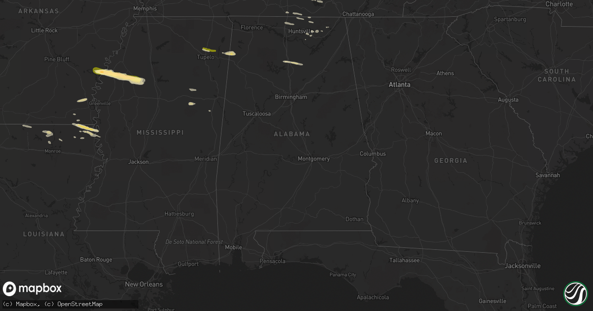
Hail Map in Alabama on April 3, 2015
Get this storm
April 3 map
$229
one time, instant access
Download today. No call, no setup
Keep the $229
Bought the map and want the full workflow? Apply the entire $229 to a subscription within 7 days. None of it is wasted.
Every map, not just this one
This buys you this map. Subscription and you get every map we run, in the markets you choose from a few cities to whole states to nationwide. Plus real-time alerts the moment a storm fires.
Contact data
Name, contact info, occupancy, even credit band for addresses in the footprint. You go from where it hit to who to call.
Become the source they trust
Unlimited branding weather history reports on demand. You already have the documented answer ready for the property owner, and you are the one who showed up with it.
Property data and RoofTrace estimates
Pull up any address you have got, its value and the exact code rules for that jurisdiction, straight from One Click Code. Then RoofTrace estimates the squares, pitch, and roof value, priced the way you price.
Storm reports in Alabama
Alabama
| Date | Description |
|---|---|
| 04/03/20156:36 PM CDT | *** 1 fatal *** a fatality occurred along hwy 157 in cloverdale after a vehical struck a fallen tree. |
| 04/02/20159:32 PM CDT | Tree down across black rd. |
| 04/02/20159:24 PM CDT | Damage to a home and garage in the cartersville area outside of ider along hwy 75. Possible tornado. |
| 04/02/20159:24 PM CDT | Multiple trees down in the fyffe area. |
| 04/02/20159:03 PM CDT | A local report indicates 1.00 inch wind near CULLMAN |
| 04/02/20159:03 PM CDT | Many trees down on highway 75... About 2 miles north of ider... Crossing between cartersville and ider. Possible tornado. |
| 04/02/20158:50 PM CDT | A local report indicates 1.00 inch wind near NEW HOPE |
| 04/02/20158:27 PM CDT | Roof damage to a residence and outbuilding near cr21/cr36. 15-20 trees snapped or uprooted in same area. |
| 04/02/20158:21 PM CDT | Tree down on elkton street in athens. Time estimated by radar. |
| 04/02/20158:03 PM CDT | Estimated 60 mph wind gusts. |
| 04/02/20158:02 PM CDT | Tree down at pulaski pike and opportunity blvd just north of the toyota plant. |
| 04/02/20157:57 PM CDT | Tree down on pebblestone drive. |
| 04/02/20157:55 PM CDT | Multiple trees were uprooted and snapped...underpinnings of a mobile home were punched in...roofing stripped off a barber shop...and a billboard was punched in as well. |
| 04/02/20157:55 PM CDT | Several trees down along hwy 43 from boligee to eutaw. |
| 04/02/20157:54 PM CDT | Power lines down on tyler will road near harvest road. Time estimated by radar. |
| 04/02/20157:53 PM CDT | Tree down on harvest road at the juction of w. Highlander. |
| 04/02/20157:50 PM CDT | Tree down on elkton street in athens. Time estimated by radar. |
| 04/02/20157:50 PM CDT | Tree down at boles road just west of greenville pike. |
| 04/02/20157:49 PM CDT | A local report indicates 1.00 inch wind near HARVEST |
| 04/02/20157:48 PM CDT | Tree down on northington road at the junction of cottonwood drive. Time estimated by radar |
| 04/02/20157:38 PM CDT | A few trees and powerlines were down on hayes mill road near piney chapel. |
| 04/02/20157:30 PM CDT | An unoccupied mobile home was moved off of its foundation and a few power outages were reported in elkmont. |
| 04/02/20157:20 PM CDT | Multiple trees were blown down on single springs church road. |
| 04/02/20157:13 PM CDT | A few trees were blown down and a shed was damaged in northern marion county. |
| 04/02/20157:03 PM CDT | Wo power poles and large trees down in lexington. Time estimated by radar. |
All States Impacted by Hail Map on April 3, 2015
Cities Impacted by Hail Map on April 3, 2015
- Rock Island, TN
- Spearsville, LA
- Lillie, LA
- Oran, MO
- McKenzie, TN
- Gleason, TN
- Dresden, TN
- Alexandria, TN
- Estill Springs, TN
- Winchester, TN
- Tullahoma, TN
- Mcminnville, TN
- Owens Cross Roads, AL
- Collinston, LA
- Bastrop, LA
- Gurley, AL
- Tazewell, TN
- Liberty, TN
- Oak Grove, LA
- Ashland City, TN
- Nashville, TN
- Saltillo, MS
- Harriman, TN
- Oakdale, TN
- Rockwood, TN
- Crossville, TN
- Oak Ridge, TN
- Crab Orchard, TN
- Kenton, TN
- Sharon, TN
- Martin, TN
- Rives, TN
- Sparta, TN
- Brooksville, MS
- Farmerville, LA
- Chaffee, MO
- Scott City, MO
- Lake Providence, LA
- Dermott, AR
- Dowelltown, TN
- Smithville, TN
- Walling, TN
- Jones, LA
- Tremont, MS
- Vina, AL
- Golden, MS
- Red Bay, AL
- Sturgis, MS
- Starkville, MS
- Mayersville, MS
- Wilmot, AR
- Ozark, IL
- Stonefort, IL
- Fulton, MS
- Rosedale, MS
- Advance, MO
- Athens, AL
- Elkmont, AL
- Simpson, IL
- Marion, LA
- Summerfield, LA
- Glendora, MS
- Charleston, MS
- Scottsboro, AL
- Cullman, AL
- Eddyville, IL
- Pegram, TN
- Kingston Springs, TN
- New Market, AL
- Shelby, MS
- Gunnison, MS
- Mound Bayou, MS
- Uniontown, KY
- Morganfield, KY
- Lynchburg, TN
- Fayetteville, TN
- Shelbyville, TN
- Prospect, TN
- Ardmore, TN
- Hanceville, AL
- Blountsville, AL
- Holly Pond, AL
- Logan, AL
- Vienna, IL
- Fackler, AL
- Madison, TN
- Whites Creek, TN
- Old Hickory, TN
- Goodlettsville, TN
- Hendersonville, TN
- Joelton, TN
- Murfreesboro, TN
- Holcomb, MS
- Tutwiler, MS
- Watson, AR
- Drew, MS
- Duncan, MS
- Parchman, MS
- Snow Lake, AR
- Minter City, MS
- Merigold, MS
- Philipp, MS
- Shawneetown, IL
- Sturgis, KY
- Toney, AL
- Harvest, AL
- Buncombe, IL
- Hazel Green, AL
- Taft, TN
- Readyville, TN
- Woodbury, TN
- Mer Rouge, LA
- Cypress, IL
- Dongola, IL
- Pioneer, LA
- Herod, IL
- Grandview, TN
- Pikeville, TN
- Maben, MS
- Pheba, MS
- Mantee, MS
- Junction, IL
- Equality, IL
- Elizabethtown, IL
- Russellville, KY
- Auburn, KY
- Woodville, AL
- Spring City, TN
- Buffalo Valley, TN
- Silver Point, TN
- Hamburg, AR
- Rolling Fork, MS
- Franklin, TN
- Fairview, TN
- Thebes, IL
- Cascilla, MS
- Trenton, AL
- Paint Rock, AL
- Guntown, MS
- Watertown, TN
- Ten Mile, TN
- Kingston, TN
- Mantachie, MS
- Henry, TN
- Paris, TN
- Tichnor, AR
- Springfield, TN
- Cottontown, TN
- Cross Plains, TN
- Portland, TN
- White House, TN
- Kit Carson, CO
- Arapahoe, CO
- Cheyenne Wells, CO
- Hoxie, KS
- Ottawa, KS
- Wellsville, KS
- Archie, MO
- Harrisonville, MO
- Drexel, MO
- Blairstown, MO
- Garden City, MO
- Urich, MO
- Creighton, MO
- Chilhowee, MO
- Louisburg, KS
- La Cygne, KS
- Osawatomie, KS
- Paola, KS


