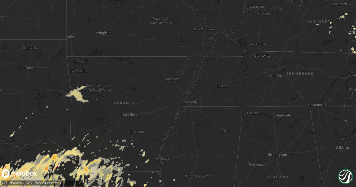
Hail Map in Arkansas on April 3, 2012
Get this storm
April 3 map
$229
one time, instant access
Download today. No call, no setup
Keep the $229
Bought the map and want the full workflow? Apply the entire $229 to a subscription within 7 days. None of it is wasted.
Every map, not just this one
This buys you this map. Subscription and you get every map we run, in the markets you choose from a few cities to whole states to nationwide. Plus real-time alerts the moment a storm fires.
Contact data
Name, contact info, occupancy, even credit band for addresses in the footprint. You go from where it hit to who to call.
Become the source they trust
Unlimited branding weather history reports on demand. You already have the documented answer ready for the property owner, and you are the one who showed up with it.
Property data and RoofTrace estimates
Pull up any address you have got, its value and the exact code rules for that jurisdiction, straight from One Click Code. Then RoofTrace estimates the squares, pitch, and roof value, priced the way you price.
Storm reports in Arkansas
Arkansas
| Date | Description |
|---|---|
| 04/02/20129:18 PM CDT | Trees down on lisbon road |
| 04/02/20129:10 PM CDT | A tree was blown down on lisbon road northwest of el dorado. |
| 04/02/20129:06 PM CDT | Trees down on aurelle road |
| 04/02/20128:35 PM CDT | Numerous trees and powerlines downe across the county |
| 04/02/20128:10 PM CDT | Trees down on hwy 160 near macedonia |
| 04/02/20128:05 PM CDT | A local report indicates 1.00 inch wind near 5 WNW BOONEVILLE |
| 04/02/20127:55 PM CDT | Several trees downed across the county. |
| 04/02/20127:51 PM CDT | Trees down in van buren and mulberry. |
| 04/02/20127:47 PM CDT | Time estimated. |
| 04/02/20127:35 PM CDT | Trees down across hwy 369 between nashville and newhope |
| 04/02/20127:35 PM CDT | Time estimated. |
| 04/02/20127:24 PM CDT | Hwy 540 and free ferry rd. |
| 04/02/20127:24 PM CDT | Hwy 540 and free ferry rd. |
| 04/02/20127:20 PM CDT | Tree down across roadway |
| 04/02/20127:20 PM CDT | Multiple trees down across the texas side of texarkana reported by the emergency manager...one on a home with no injuries. |
| 04/02/20127:20 PM CDT | Golf ball sized hail reported by broadcast media. |
| 04/02/20127:15 PM CDT | Quarter size hail fell near the community of marysville. |
| 04/02/20127:10 PM CDT | Quarter sized hail reported by law enforcement. |
| 04/02/20127:00 PM CDT | Trees and power lines down across entire county |
All States Impacted by Hail Map on April 3, 2012
Cities Impacted by Hail Map on April 3, 2012
- Manchester, KY
- Annona, TX
- Flower Mound, TX
- Grapevine, TX
- Lewisville, TX
- Madill, OK
- Vivian, LA
- Oil City, LA
- Jasper, TX
- Woodville, TX
- Kerens, TX
- Austin, TX
- Livingston, TX
- Coldspring, TX
- Goodrich, TX
- Shepherd, TX
- Cleveland, TX
- Milano, TX
- Gause, TX
- Caldwell, TX
- Hemphill, TX
- Grandview, TX
- Itasca, TX
- Hillsboro, TX
- Shreveport, LA
- Keithville, LA
- Huntsville, TX
- Annville, KY
- Clinton, LA
- Simsboro, LA
- Arcadia, LA
- Graham, TX
- Sidney, TX
- Comanche, TX
- Rockwall, TX
- Ranger, TX
- Waynesville, NC
- Ellabell, GA
- Shelbyville, TX
- London, KY
- Atlanta, TX
- Fort Smith, AR
- Hilliard, FL
- Folkston, GA
- Saint George, GA
- Glenmora, LA
- Oakdale, LA
- Marshall, TX
- Henderson, TX
- Azle, TX
- Morgan, TX
- Meridian, TX
- Clifton, TX
- Mabank, TX
- Eustace, TX
- Jacksonville, FL
- Monticello, FL
- Tallahassee, FL
- Carthage, TX
- Como, TX
- Sulphur Bluff, TX
- Sulphur Springs, TX
- Deport, TX
- Quitman, TX
- Yantis, TX
- Winnsboro, TX
- Lake Creek, TX
- Saltillo, TX
- Brashear, TX
- Dike, TX
- Mount Vernon, TX
- Pickton, TX
- Bogata, TX
- Cumby, TX
- Covington, TX
- Milford, TX
- Meadowview, VA
- Mount Calm, TX
- Hubbard, TX
- Coolidge, TX
- Groesbeck, TX
- Riesel, TX
- Marlin, TX
- Thornton, TX
- Canton, NC
- Shongaloo, LA
- Cotton Valley, LA
- Haynesville, LA
- Minden, LA
- Plain Dealing, LA
- Merryville, LA
- Warrenton, GA
- West Monroe, LA
- Downsville, LA
- Batchelor, LA
- Navasota, TX
- Montgomery, TX
- Plantersville, TX
- New Waverly, TX
- Conroe, TX
- Willis, TX
- Waco, TX
- Crawford, TX
- China Spring, TX
- Valley Mills, TX
- Woodway, TX
- Ruston, LA
- Hamburg, AR
- Montrose, AR
- Paige, TX
- Smithville, TX
- Palo Pinto, TX
- Graford, TX
- Oak Grove, LA
- Bryan, OH
- Ney, OH
- Edgerton, OH
- Dallas, TX
- Fordyce, AR
- Rison, AR
- Strawn, TX
- Caddo Mills, TX
- Greenville, TX
- Mason, OH
- Cincinnati, OH
- Maineville, OH
- Loveland, OH
- Pioneer, TN
- Eidson, TN
- Colmesneil, TX
- West, TX
- Bruceville, TX
- Lorena, TX
- Chilton, TX
- Mansfield, LA
- Biloxi, MS
- Gulfport, MS
- Bossier City, LA
- Lake Park, GA
- Stephenville, TX
- Lipan, TX
- Santo, TX
- Weatherford, TX
- Millsap, TX
- Burkeville, TX
- Lake Charles, LA
- Tyler, TX
- Bullard, TX
- Lindale, TX
- Palestine, TX
- Flint, TX
- Whitehouse, TX
- Winona, TX
- Hawkins, TX
- Arp, TX
- Frankston, TX
- Big Sandy, TX
- Gilmer, TX
- Jacksonville, TX
- Krotz Springs, LA
- Carrollton, TX
- Irving, TX
- Fouke, AR
- Wise, VA
- Pound, VA
- Washburn, TN
- Rutledge, TN
- Taylor, AR
- Lewisville, AR
- Arlington, TX
- Mansfield, TX
- Grand Prairie, TX
- Junction City, AR
- Emerson, AR
- Lexington, TX
- Lincoln, TX
- New Orleans, LA
- Austinville, VA
- Hillsville, VA
- Ridge Spring, SC
- Batesburg, SC
- Silverstreet, SC
- Leesville, SC
- Ward, SC
- Johnston, SC
- Newberry, SC
- Prosperity, SC
- Saluda, SC
- Whitney, TX
- Crockett, TX
- Midlothian, TX
- Cedar Hill, TX
- Waxahachie, TX
- Covington, LA
- Folsom, LA
- Madisonville, LA
- Maurice, LA
- Duson, LA
- Lafayette, LA
- Hackett, AR
- Nashville, AR
- Mineral Wells, TX
- Seminary, MS
- Collins, MS
- Bivins, TX
- Circleville, OH
- Chillicothe, OH
- Kingston, OH
- Morgan City, LA
- Homer, LA
- Boston, GA
- Quitman, GA
- Dixie, GA
- Jennings, FL
- Athens, TN
- Chapin, SC
- Jacksboro, TX
- Bryson, TX
- Nocona, TX
- Montague, TX
- Bowie, TX
- Saint Jo, TX
- Mineola, TX
- Bedford, TX
- Hurst, TX
- Coppell, TX
- Frisco, TX
- Colleyville, TX
- Fort Worth, TX
- Euless, TX
- The Colony, TX
- Richland, TX
- Wortham, TX
- Streetman, TX
- Corsicana, TX
- Randlett, OK
- Burneyville, OK
- Wilson, OK
- Overbrook, OK
- Reserve, LA
- Garyville, LA
- Edgard, LA
- Doddridge, AR
- Bremond, TX
- Malone, TX
- Penelope, TX
- Abbott, TX
- Bynum, TX
- Williamsburg, KY
- Siler, KY
- Booneville, KY
- Ricetown, KY
- Abbeville, LA
- Erath, LA
- Quitman, LA
- Pavo, GA
- Burlington, TX
- Rogers, TX
- Lott, TX
- Temple, TX
- Rosebud, TX
- Holden, LA
- Independence, LA
- Fairfield, TX
- Powell, TX
- Kemp, TX
- Rice, TX
- Chatfield, TX
- Springhill, LA
- Sarepta, LA
- Jermyn, TX
- Henrietta, TX
- Loving, TX
- Springtown, TX
- Paradise, TX
- Poolville, TX
- Rosser, TX
- Scurry, TX
- Campbell, TX
- College Station, TX
- Bryan, TX
- Bellevue, TX
- Breckenridge, TX
- Farmerville, LA
- Rising Star, TX
- Carbon, TX
- Gorman, TX
- Eastland, TX
- Nevada, TX
- Farmersville, TX
- Larue, TX
- Grapeland, TX
- Elkhart, TX
- Pittsburg, TX
- Teague, TX
- Mexia, TX
- Chandler, TX
- Oakwood, TX
- Montalba, TX
- Brownsboro, TX
- Ben Wheeler, TX
- Tennessee Colony, TX
- Lovelady, TX
- Trinidad, TX
- Midway, TX
- Buffalo, TX
- Kosse, TX
- Rusk, TX
- Benton, LA
- Leonard, TX
- Pineville, KY
- Joshua, TX
- Keene, TX
- Cleburne, TX
- Cornettsville, KY
- Hallie, KY
- Blackey, KY
- Barksdale Afb, LA
- Wells, TX
- Alto, TX
- Roanoke, LA
- Welsh, LA
- Jennings, LA
- Franklin, TX
- Calvert, TX
- Hendersonville, NC
- Whitesburg, KY
- Jena, LA
- Sibley, LA
- Olney, TX
- Hope, AR
- Viper, KY
- Mount Pleasant, TX
- North Richland Hills, TX
- Winnsboro, LA
- Fort Necessity, LA
- Kiln, MS
- Bay Saint Louis, MS
- Diamondhead, MS
- Picayune, MS
- Kountze, TX
- Magnolia, AR
- Cisco, TX
- Cross Plains, TX
- Rogersville, TN
- Greeneville, TN
- El Dorado, AR
- Mount Holly, AR
- Granbury, TX
- Mckinney, TX
- Allen, TX
- Anderson, SC
- Ravenna, KY
- Bunkie, LA
- Woodville, MS
- Southlake, TX
- Saint Francisville, LA
- Frost, TX
- Italy, TX
- Mertens, TX
- Prentiss, MS
- Bedias, TX
- Danielsville, GA
- Maggie Valley, NC
- Emory, TX
- Coeburn, VA
- Clintwood, VA
- Richmond, KY
- Center, TX
- Blum, TX
- Charleston, AR
- Ocean Springs, MS
- Gautier, MS
- Murchison, TX
- Lake Junaluska, NC
- Newcastle, TX
- Lone Grove, OK
- Ardmore, OK
- Ashdown, AR
- Bean Station, TN
- Wapakoneta, OH
- Madisonville, TX
- Berea, KY
- Paint Lick, KY
- Statham, GA
- Bogart, GA
- Monroe, GA
- Bishop, GA
- Forney, TX
- Mesquite, TX
- Rowlett, TX
- Sunnyvale, TX
- Monterey, LA
- Moreauville, LA
- Killeen, TX
- Talco, TX
- Detroit, TX
- Rodessa, LA
- Hosston, LA
- Bradley, AR
- Ida, LA
- Jefferson, TX
- Kinder, LA
- McKee, KY
- Louann, AR
- Camden, AR
- Ballinger, TX
- Evans, LA
- Aquilla, TX
- Vicksburg, MS
- Florien, LA
- Townsend, TN
- Grambling, LA
- Cable, OH
- North Lewisburg, OH
- Prestonsburg, KY
- Cameron, TX
- Chester, SC
- Dubach, LA
- Choudrant, LA
- Gladewater, TX
- Pattison, MS
- Statenville, GA
- Toccoa, GA
- Silver Creek, MS
- Duff, TN
- Garland, TX
- Fayette, MS
- Godley, TX
- Cresson, TX
- Moultrie, GA
- Hagerhill, KY
- Harvey, LA
- Mountainburg, AR
- Alma, AR
- Coolidge, GA
- Crowell, TX
- Hermanville, MS
- Monticello, AR
- Coalgate, OK
- Moselle, MS
- Hattiesburg, MS
- Jewett, TX
- Donie, TX
- McGregor, TX
- Little Mountain, SC
- Calvin, KY
- Middlesboro, KY
- Terrell, TX
- Commerce, TX
- Balch Springs, TX
- Quinlan, TX
- Wilmer, TX
- Hutchins, TX
- Lone Oak, TX
- Lancaster, TX
- Royse City, TX
- Thomasville, GA
- Lettsworth, LA
- Gonzales, TX
- Sparkman, AR
- Bearden, AR
- Laurel Springs, NC
- Gainesville, GA
- Galax, VA
- Independence, VA
- Max Meadows, VA
- Napoleonville, LA
- Pierre Part, LA
- Pendleton, SC
- Williamston, SC
- Pelzer, SC
- Clairfield, TN
- Frakes, KY
- Simms, TX
- De Kalb, TX
- Yazoo City, MS
- Booneville, AR
- Greenwood, AR
- Monroe, LA
- Sterlington, LA
- Mozelle, KY
- Warbranch, KY
- Newark, TX
- Abilene, TX
- Tuscola, TX
- Belcher, LA
- Norwood, GA
- Ermine, KY
- Thornton, KY
- Premium, KY
- Isom, KY
- Millstone, KY
- Pine Top, KY
- Deane, KY
- Thornton, AR
- Van Buren, AR
- Lavaca, AR
- Nora, VA
- Ennis, TX
- Blooming Grove, TX
- Barry, TX
- Cookville, TX
- Greenback, TN
- Evergreen, LA
- Forest Hill, LA
- Hooks, TX
- Texarkana, TX
- Foreman, AR
- New Boston, TX
- Kaufman, TX
- La Follette, TN
- Jellico, TN
- Rayville, LA
- Duffield, VA
- Surgoinsville, TN
- McDade, TX
- Talpa, TX
- Waldo, AR
- Harker Heights, TX
- Gillsville, GA
- Blue River, KY
- Church Hill, TN
- Augusta, GA
- Pennington, TX
- Apple Springs, TX
- Trinity, TX
- Groveton, TX
- Bronson, TX
- Winfield, TX
- Avery, TX
- New Roads, LA
- Rayne, LA
- Holliday, TX
- Statesboro, GA
- Campbellsville, KY
- Sontag, MS
- Brookhaven, MS
- Sachse, TX
- Addison, TX
- Plano, TX
- Wylie, TX
- Lake Dallas, TX
- Roanoke, TX
- Barbourville, KY
- Krum, TX
- Gloster, LA
- Frierson, LA
- Stonewall, LA
- Amite, LA
- Lancaster, KY
- Blanco, TX
- Memphis, TX
- Point, TX
- Kaplan, LA
- Nacogdoches, TX
- Tuckasegee, NC
- Burleson, TX
- Crowley, TX
- Gibsland, LA
- Athens, LA
- Elm Mott, TX
- Bluff Dale, TX
- Desdemona, TX
- Mingus, TX
- Dublin, TX
- Gordon, TX
- De Leon, TX
- Plaquemine, LA
- Stanton, KY
- Slade, KY
- Aledo, TX
- Hoboken, GA
- Klondike, TX
- Ferris, TX
- Red Oak, TX
- Crandall, TX
- Palmer, TX
- Seagoville, TX
- Tolar, TX
- Thorndale, TX
- San Augustine, TX
- Natchitoches, LA
- Wills Point, TX
- Canton, TX
- Tyner, KY
- Georgetown, TX
- Round Rock, TX
- Longview, TX
- White Oak, TX
- Lexington, IL
- Towanda, IL
- Boyd, TX
- Ponder, TX
- Rhome, TX
- Decatur, TX
- Haslet, TX
- Justin, TX
- Ventress, LA
- Blue Ridge, TX
- Nahunta, GA
- Patterson, GA
- Waycross, GA
- Blackshear, GA
- Terral, OK
- Ryan, OK
- Eddy, TX
- Burkett, TX
- Bernice, LA
- Buckner, AR
- Linden, TX
- Stamps, AR
- Mooringsport, LA
- Avinger, TX
- Queen City, TX
- Bloomburg, TX
- Garland City, AR
- Texarkana, AR
- Bellefontaine, OH
- Basile, LA
- Eunice, LA
- Jackson, KY
- Vest, KY
- White Castle, LA
- Donaldsonville, LA
- May, TX
- Helton, KY
- Jonesboro, LA
- Chatham, LA
- Livingston, LA
- Athens, TX
- Cullowhee, NC
- Glenville, NC
- Union Church, MS
- Bledsoe, KY
- Grays Knob, KY
- Harlan, KY
- Ages Brookside, KY
- Coalgood, KY
- Baxter, KY
- Cawood, KY
- Chireno, TX
- Elkhorn City, KY
- Rockdale, TX
- McClure, VA
- Lufkin, TX
- Ringgold, TX
- Healdton, OK
- Ringling, OK
- Coleman, TX
- Crowley, LA
- Iota, LA
- Dauphin Island, AL
- Grand Chenier, LA
- Commerce, GA
- Dripping Springs, TX
- Fargo, GA
- Gays Creek, KY
- Centerville, TX
- Desoto, TX
- Estill, SC
- Luray, SC
- Alvarado, TX
- Lillian, TX
- Anna, TX
- Princeton, TX
- Kirbyville, TX
- Yoakum, TX
- Eolia, KY
- Leesville, LA
- Clinchco, VA
- Dante, VA
- Belle Rose, LA
- Lakeview, OH
- Huntsville, OH
- Russells Point, OH
- Salyersville, KY
- East Bernstadt, KY
- Robeline, LA
- Thrall, TX
- Guyton, GA
- Brevard, NC
- Perrin, TX
- Magazine, AR
- Maysville, GA
- Haughton, LA
- Elm Grove, LA
- Ellijay, GA
- Dawsonville, GA
- Lima, OH
- Saint Martinville, LA
- Pisgah Forest, NC
- Angola, LA
- Mclean, TX
- Pageland, SC
- Cranfills Gap, TX
- Appalachia, VA
- Norton, VA
- Big Stone Gap, VA
- Pass Christian, MS
- Transylvania, LA
- Redwood, MS
- Alexandria, LA
- Pineville, LA
- Oil Springs, KY
- Axtell, TX
- Forreston, TX
- Barataria, LA
- Marrero, LA
- Lafitte, LA
- Doyline, LA
- Hoschton, GA
- Jefferson, GA
- Morton, MS
- Pelahatchie, MS
- Belton, TX
- Warren, TX
- Jefferson, NC
- Scottville, NC
- Jeanerette, LA
- Little Elm, TX
- Grand Saline, TX
- Mart, TX
- Maypearl, TX
- Troy, TX
- Oglesby, TX
- Venus, TX
- Denton, TX
- Prosper, TX
- Cooper, TX
- Edgewood, TX
- Alba, TX
- Lavon, TX
- Kopperl, TX
- Hewitt, TX
- Haltom City, TX
- Paris, TX
- Celeste, TX
- Keller, TX
- Richardson, TX
- Nemo, TX
- Duncanville, TX
- Wolfe City, TX
- Rainbow, TX
- Nash, TX
- Kennedale, TX
- Pattonville, TX
- Clarksville, TX
- Van, TX
- Scroggins, TX
- Leesburg, TX
- Moody, TX
- Naval Air Station Jrb, TX
- Cloverdale, OH
- Long Branch, TX
- Diana, TX
- Ben Franklin, TX
- Lillie, LA
- Archer City, TX
- Karnack, TX
- Ore City, TX
- Elgin, TX
- Summerfield, LA
- Buckholts, TX
- Keatchie, LA
- Rio Vista, TX
- Greenwood, LA
- Dawson, TX
- Malakoff, TX
- Ogden, AR
- Enloe, TX
- Lisbon, LA
- Reagan, TX
- Heflin, LA
- Stephens, AR
- Wichita Falls, TX
- Hamilton, TX
- Troup, TX
- Scotland, TX
- Spearsville, LA
- Blanchard, LA
- Princeton, LA
- Roxton, TX
- McNeil, AR
- Ringgold, LA
- Haworth, OK
- Hico, TX
- Fruitvale, TX
- Leon, OK
- Glen Rose, TX
- Jonesboro, TX
- Windthorst, TX
- Pennington Gap, VA
- Jonesville, VA
- Jonesville, LA
- Maryville, TN
- Corrigan, TX
- Daviston, AL
- Jacksons Gap, AL
- Alexander City, AL
- Wallins Creek, KY
- Monroe, NC
- Maurepas, LA
- Sylvania, GA
- Maud, TX
- Oberlin, LA
- Deridder, LA
- Church Point, LA
- Dahlonega, GA
- Longville, LA
- Arnaudville, LA
- Carencro, LA
- Ponchatoula, LA
- Hammond, LA
- Springfield, LA
- Iola, TX
- Hueysville, KY
- Martin, KY
- Mineral Springs, AR
- Ozan, AR
- Long Beach, MS
- Delphos, OH
- Franklinton, LA
- Mount Hermon, LA
- Winters, TX
- Dequincy, LA
- Smithdale, MS
- McCall Creek, MS
- Bogue Chitto, MS
- Grand Cane, LA
- Hamilton, IN
- Butler, IN
- Abita Springs, LA
- New Edinburg, AR
- Sulphur, OK
- Meadville, MS
- Harrisonburg, LA
- Sicily Island, LA
- Marion, LA
- De Queen, AR
- Clarendon, TX
- Nancy, KY
- Atoka, OK
- Irmo, SC
- Pomaria, SC
- Stennis Space Center, MS
- Dandridge, TN
- Royston, GA
- Wesson, MS
- Hornbeck, LA
- Pampa, TX
- Castor, LA
- West Liberty, KY
- Lorman, MS
- Oakdale, TN
- Strunk, KY
- Delphia, KY
- Lakeview, TX
- Wardville, OK
- Saint Landry, LA
- Anderson, TX
- Mamou, LA
- Lavonia, GA
- Martin, GA
- Carnesville, GA
- Delight, AR
- Maringouin, LA
- Strong, AR
- Newton, TX
- Pascagoula, MS
- Edwards, MS
- Kennard, TX
- Roland, OK
- Spiro, OK
- Pocola, OK
- Muldrow, OK
- Arkoma, OK
- Dyer, AR
- Barling, AR
- Rudy, AR
- Mulberry, AR
- Ozark, AR
- Westwego, LA
- Omaha, TX
- Carrizo Springs, TX
- Thorn Hill, TN
- Lancing, TN
- Sextons Creek, KY
- Elton, LA
- Brownwood, TX
- Revelo, KY
- Pine Knot, KY
- Stearns, KY
- Shiner, TX
- Purdon, TX
- Redfox, KY
- Sulphur, LA
- Westlake, LA
- Englewood, TN
- Hollandale, MS
- Pearl River, LA
- Cecil, OH
- Fort Blackmore, VA
- Buda, TX
- Epworth, GA
- Lake Providence, LA
- Geismar, LA
- Lecompte, LA
- Blanchester, OH
- Chidester, AR
- Lenoir City, TN
- Breaux Bridge, LA
- Hustonville, KY
- Tishomingo, OK
- Milburn, OK
- Scott, LA
- Quincy, FL
- Gatesville, TX
- Fort Hood, TX
- Du Pont, GA
- Tenaha, TX
- Hampton, AR
- Celina, TX
- Wilburton, OK
- Muenster, TX
- Talmo, GA
- Rayle, GA
- Watkinsville, GA
- Waynesfield, OH
- Goldonna, LA
- Somerville, TX
- Carriere, MS
- Bush, LA
- East Point, KY
- Caryville, TN
- Hahnville, LA
- Luling, LA
- Grovetown, GA
- Harlem, GA
- Giddings, TX
- Naples, TX
- Clyde, NC
- Leicester, NC
- Candler, NC
- Port Gibson, MS
- Crosby, MS
- Hempstead, TX
- Zanesfield, OH
- West Liberty, OH
- Kiowa, OK
- Ivan, AR
- Saint Amant, LA
- Jeremiah, KY
- Gordon, KY
- Letcher, KY
- Olla, LA
- Vincent, KY
- Port Allen, LA
- Brusly, LA
- Slidell, LA
- Rockwood, TN
- Lueders, TX
- Winder, GA
- Roanoke, AL
- Hartsville, SC
- Kenefic, OK
- Beattyville, KY
- Trenton, SC
- Aiken, SC
- Brookeland, TX
- Wiergate, TX
- Sunset, LA
- Opelousas, LA
- Kingsland, AR
- Daingerfield, TX
- Douglass, TX
- Gunlock, KY
- Goshen, OH
- Provencal, LA
- Jenkins, KY
- Pikeville, KY
- Branch, LA
- Monticello, MS
- Waurika, OK
- Saratoga, TX
- Waelder, TX
- Emmet, AR
- Neon, KY
- Sanger, TX
- Lebanon, VA
- Fairfield, OH
- Kenner, LA
- Metairie, LA
- Stanford, KY
- Continental, OH
- Brooklet, GA
- Cranks, KY
- Kilgore, TX
- Athens, GA
- Gray, KY
- Hutto, TX
- Starks, LA
- Trout, LA
- Ragley, LA
- Soperton, GA
- North Augusta, SC
- Beech Island, SC
- Windsor, KY
- Liberty, KY
- Paris, AR
- Sneedville, TN
- Loudon, TN
- Georgetown, LA
- Waveland, MS
- Hughes Springs, TX
- Braselton, GA
- Saratoga, AR
- Heavener, OK
- Mount Enterprise, TX
- Harriman, TN
- Bluff City, AR
- Rosston, AR
- Thibodaux, LA
- Deville, LA
- Center Point, LA
- Eastanollee, GA
- Franklin, LA
- Wilmar, AR
- Rockholds, KY
- Lockesburg, AR
- Crossett, AR
- Crumpler, NC
- Piney Creek, NC
- Sparta, NC
- Des Allemands, LA
- Coden, AL
- Cumming, GA
- Converse, LA
- Clarkesville, GA
- Long Creek, SC
- Blair, SC
- Valera, TX
- Raceland, LA
- Cullom, IL
- Carlisle, SC
- Penrose, NC
- Kings Mountain, KY
- Middleburg, KY
- Yosemite, KY
- Clarksville, OH
- Oregonia, OH
- Ceres, VA
- Tazewell, VA
- Arkadelphia, AR
- Wadley, AL
- Haskell, TX
- Stamford, TX
- Grand Bay, AL
- Marksville, LA
- Dearing, GA
- David, KY
- Ochlocknee, GA
- Bogalusa, LA


