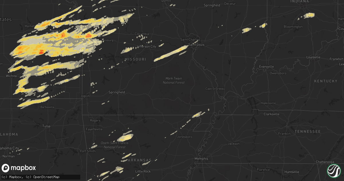
Hail Map in Kansas on April 3, 2011
Get this storm
April 3 map
$229
one time, instant access
Download today. No call, no setup
Keep the $229
Bought the map and want the full workflow? Apply the entire $229 to a subscription within 7 days. None of it is wasted.
Every map, not just this one
This buys you this map. Subscription and you get every map we run, in the markets you choose from a few cities to whole states to nationwide. Plus real-time alerts the moment a storm fires.
Contact data
Name, contact info, occupancy, even credit band for addresses in the footprint. You go from where it hit to who to call.
Become the source they trust
Unlimited branding weather history reports on demand. You already have the documented answer ready for the property owner, and you are the one who showed up with it.
Property data and RoofTrace estimates
Pull up any address you have got, its value and the exact code rules for that jurisdiction, straight from One Click Code. Then RoofTrace estimates the squares, pitch, and roof value, priced the way you price.
Storm reports in Kansas
Kansas
| Date | Description |
|---|---|
| 04/03/20116:59 PM CDT | 21st and fairlawn |
| 04/03/20116:58 PM CDT | A local report indicates 1.00 inch wind near 3 W HOYT |
| 04/03/20116:58 PM CDT | Roof damage at 21st and wanamaker. Power lines down. |
| 04/03/20116:56 PM CDT | Spotter was located 3 miles east of st. Marys on hwy 24. Winds estimated 40-50 mph. |
| 04/03/20116:50 PM CDT | A local report indicates 1.75 inch wind near ENE DELIA |
| 04/03/20116:50 PM CDT | Possible beginning point of damage from significant microburst near 25th and sacremento. Rain foot witnessed looking south from the silver lake area. Fences blown down. |
| 04/03/20116:49 PM CDT | A local report indicates 1.00 inch wind near ENE DELIA |
| 04/03/20116:45 PM CDT | A local report indicates 1.75 inch wind near ST. MARYS |
| 04/03/20116:45 PM CDT | A local report indicates 1.00 inch wind near 3 W ROSSVILLE |
| 04/03/20116:43 PM CDT | A local report indicates 1.75 inch wind near W ST. MARYS |
| 04/03/20116:42 PM CDT | A local report indicates 1.25 inch wind near 1 NNE ST. MARYS |
| 04/03/20116:42 PM CDT | A local report indicates 1.25 inch wind near 3 SSE BELVUE |
| 04/03/20116:23 PM CDT | A local report indicates 1.00 inch wind near 1 W WAMEGO |
| 04/03/20116:23 PM CDT | A local report indicates 1.00 inch wind near 8 SW WAMEGO |
| 04/03/20116:20 PM CDT | Hail nickel to quarter size. |
| 04/03/20116:15 PM CDT | A local report indicates 1.00 inch wind near 2 NE ST. GEORGE |
| 04/02/201110:48 PM CDT | Tree blown over north of mound city along highway 7...delayed report |
| 04/02/201110:38 PM CDT | Dime and quarter size hail |
| 04/02/201110:27 PM CDT | A local report indicates 60 MPH wind near S KINCAID |
| 04/02/201110:15 PM CDT | A local report indicates 1.00 inch wind near 4 NW IOLA |
| 04/02/20119:56 PM CDT | A local report indicates 1.25 inch wind near 8 N YATES CENTER |
| 04/02/20119:51 PM CDT | A local report indicates 1.00 inch wind near 2 NE WINFIELD |
| 04/02/20119:50 PM CDT | A local report indicates 1.00 inch wind near 10 W YATES CENTER |
| 04/02/20119:50 PM CDT | 60 to 70 mph gusts. 4 to 6 inch limbs down. |
| 04/02/20119:45 PM CDT | A local report indicates 1.00 inch wind near PARKER |
| 04/02/20119:43 PM CDT | Golfball size hail reported on the southwest side of winfield. |
| 04/02/20119:43 PM CDT | 62 mph wind gusts and quarter size hail was reported in winfield. |
| 04/02/20119:40 PM CDT | A local report indicates 1.25 inch wind near 3 S OSAWATOMIE |
| 04/02/20119:26 PM CDT | Delayed report...sustained winds were estimated at 70 mph associated with the thunderstorms on the evening of april 3rd. |
| 04/02/20119:26 PM CDT | A local report indicates 1.50 inch wind near 1 S PRINCETON |
| 04/02/20119:25 PM CDT | Wind damage reported in several locations across anderson county. Roof removed from barn...windows broken out of home...shingles off of homes...a missing carport. More |
| 04/02/20119:25 PM CDT | Winds estimated at 80 mph with possible damage. |
| 04/02/20119:22 PM CDT | Awos at the airport near eureka measured a gust of 59 mph. |
| 04/02/20119:21 PM CDT | A local report indicates 60 MPH wind near DOUGLASS |
| 04/02/20119:20 PM CDT | Limbs down |
| 04/02/20119:19 PM CDT | A local report indicates 1.00 inch wind near DOUGLASS |
| 04/02/20119:18 PM CDT | Hail lasted 10 to 15 mins |
| 04/02/20119:15 PM CDT | A local report indicates 1.50 inch wind near LEAWOOD |
| 04/02/20119:15 PM CDT | 2 miles ne of ojc airport. Roof damage reported. |
| 04/02/20119:14 PM CDT | A local report indicates 1.00 inch wind near 2 S LYNDON |
| 04/02/20119:10 PM CDT | A local report indicates 1.50 inch wind near WAVERLY |
| 04/02/20119:08 PM CDT | A local report indicates 1.00 inch wind near 1 W OLIVET |
| 04/02/20119:08 PM CDT | Tree branches down approx 1-2 inches in diameter. |
| 04/02/20119:07 PM CDT | A local report indicates 1.50 inch wind near 9 NNE BURLINGTON |
| 04/02/20119:07 PM CDT | A local report indicates 70 MPH wind near ROSALIA |
| 04/02/20119:06 PM CDT | A local report indicates 1.50 inch wind near OLATHE |
| 04/02/20119:05 PM CDT | Near 159th and metcalf |
| 04/02/20119:04 PM CDT | A local report indicates 1.75 inch wind near 2 SSW OLATHE |
| 04/02/20119:03 PM CDT | A local report indicates 1.00 inch wind near 3 S MELVERN |
| 04/02/20119:00 PM CDT | Coffey co airport awos measurement |
| 04/02/20119:00 PM CDT | A local report indicates 1.00 inch wind near GARDNER |
| 04/02/20119:00 PM CDT | Delayed report...sustained winds were estimated at 70 mph associated with the thunderstorms on the evening of april 3rd. |
| 04/02/20118:56 PM CDT | A local report indicates 1.00 inch wind near 6 NNW EL DORADO |
| 04/02/20118:56 PM CDT | A local report indicates 1.25 inch wind near 2 N OLATHE |
| 04/02/20118:55 PM CDT | 6 inch tree limbs were downed 8 miles north and 2 miles west of el dorado. |
| 04/02/20118:48 PM CDT | A local report indicates 60 MPH wind near EL DORADO |
| 04/02/20118:48 PM CDT | A local report indicates 1.00 inch wind near 5 ESE WILLIAMSTOWN |
| 04/02/20118:47 PM CDT | A local report indicates 1.00 inch wind near 1 S EUDORA |
| 04/02/20118:45 PM CDT | Relayed by emergency management |
| 04/02/20118:45 PM CDT | Estimated 50 mph winds. Hail lasted less than 5 mins. |
| 04/02/20118:44 PM CDT | West side of baldwin city. Relayed by emergency management. |
| 04/02/20118:43 PM CDT | A local report indicates 1.00 inch wind near STRONG CITY |
| 04/02/20118:43 PM CDT | Relayed by ksn. |
| 04/02/20118:41 PM CDT | A local report indicates 1.00 inch wind near RICHMOND |
| 04/02/20118:41 PM CDT | A local report indicates 1.00 inch wind near 1 W LAWRENCE |
| 04/02/20118:41 PM CDT | A local report indicates 1.75 inch wind near 7 N BENTON |
| 04/02/20118:41 PM CDT | Estimated 50 mph winds |
| 04/02/20118:41 PM CDT | A local report indicates 2.75 inch wind near 2 S EMPORIA |
| 04/02/20118:41 PM CDT | A local report indicates 1.25 inch wind near 4 N EMPORIA |
| 04/02/20118:40 PM CDT | Time approximated. Reports of roof damage...small sheds and barns destroyed...and a roof removed from a home in the general americus area. |
| 04/02/20118:40 PM CDT | At intersection of bob billings and iowa in lawrence. |
| 04/02/20118:40 PM CDT | A local report indicates 1.75 inch wind near 4 ENE EMPORIA |
| 04/02/20118:40 PM CDT | A local report indicates 1.25 inch wind near 1 WNW EMPORIA |
| 04/02/20118:40 PM CDT | Time approximated. |
| 04/02/20118:40 PM CDT | A local report indicates 1.75 inch wind near 6 N BURLINGAME |
| 04/02/20118:39 PM CDT | A local report indicates 1.00 inch wind near 3 SSW LAWRENCE |
| 04/02/20118:38 PM CDT | A local report indicates 1.00 inch wind near 7 N BENTON |
| 04/02/20118:37 PM CDT | Multiple power poles were knocked down which sparked a grass fire at highway 196 just north of highway 254. |
| 04/02/20118:36 PM CDT | A local report indicates 70 MPH wind near 4 SW CARBONDALE |
| 04/02/20118:35 PM CDT | A local report indicates 1.00 inch wind near OSAGE CITY |
| 04/02/20118:35 PM CDT | A local report indicates 1.50 inch wind near PLEASANT GROVE |
| 04/02/20118:35 PM CDT | Sizes ranged from nickel to half dollar size. |
| 04/02/20118:32 PM CDT | A local report indicates 1.50 inch wind near 2 SSW BURDICK |
| 04/02/20118:32 PM CDT | Wind gusts to 65 mph were also estimated. |
| 04/02/20118:32 PM CDT | A local report indicates 1.00 inch wind near 2 NNW CLINTON |
| 04/02/20118:26 PM CDT | 42nd and adams and 29th and croco. |
| 04/02/20118:26 PM CDT | A local report indicates 1.00 inch wind near 9 SE TOPEKA |
| 04/02/20118:26 PM CDT | A local report indicates 1.00 inch wind near 2 NNE BERRYTON |
| 04/02/20118:25 PM CDT | A local report indicates 1.75 inch wind near OVERBROOK |
| 04/02/20118:25 PM CDT | A local report indicates 2.00 inch wind near LONE STAR |
| 04/02/20118:25 PM CDT | A local report indicates 1.00 inch wind near 2 SSW BURDICK |
| 04/02/20118:25 PM CDT | A local report indicates 60 MPH wind near 2 SSW BURDICK |
| 04/02/20118:23 PM CDT | Near 89th and paulen road. Delayed report |
| 04/02/20118:23 PM CDT | A local report indicates 1.75 inch wind near 2 NW RICHLAND |
| 04/02/20118:22 PM CDT | A local report indicates 1.00 inch wind near FORBES FIELD |
| 04/02/20118:20 PM CDT | A local report indicates 63 MPH wind near WICHITA MID CONTINENT A |
| 04/02/20118:20 PM CDT | A local report indicates 1.75 inch wind near 11 N EMPORIA |
| 04/02/20118:20 PM CDT | A local report indicates 1.50 inch wind near OVERBROOK |
| 04/02/20118:19 PM CDT | A local report indicates 1.25 inch wind near CARBONDALE |
| 04/02/20118:19 PM CDT | A local report indicates 1.25 inch wind near 4 E CARBONDALE |
| 04/02/20118:17 PM CDT | A local report indicates 1.50 inch wind near 3 S BUSHONG |
| 04/02/20118:17 PM CDT | A local report indicates 1.25 inch wind near 5 SSE BUSHONG |
| 04/02/20118:13 PM CDT | A local report indicates 1.00 inch wind near S CARBONDALE |
| 04/02/20118:11 PM CDT | Power outages in the area of 153rd and briarwood with debris in the power lines. |
| 04/02/20118:05 PM CDT | A local report indicates 1.25 inch wind near BURLINGAME |
| 04/02/20118:04 PM CDT | Shingles off roofs of several homes. 14 inch diameter tree was 30 feet high and snapped off from trunk. Metal shed 10 by 10 destroyed. Near 153rd and briarwood |
| 04/02/20117:59 PM CDT | A local report indicates 1.00 inch wind near SE ESKRIDGE |
| 04/02/20117:58 PM CDT | A local report indicates 1.00 inch wind near 5 S COUNCIL GROVE |
| 04/02/20117:49 PM CDT | Dime to quarter size hail |
| 04/02/20117:49 PM CDT | Power lines were downed along railroad tracks also. Power lines were flashing near elmdale. |
| 04/02/20117:45 PM CDT | A local report indicates 1.75 inch wind near 4 NE MARION |
| 04/02/20117:40 PM CDT | Quarter to golfball size hail was covering the ground. 50 mph wind gusts also occurred with the hail. |
| 04/02/20117:37 PM CDT | A local report indicates 1.25 inch wind near BURDICK |
| 04/02/20117:36 PM CDT | A local report indicates 1.00 inch wind near 11 SSW ALMA |
| 04/02/20117:34 PM CDT | 4 miles w of fort leavenworth |
| 04/02/20117:29 PM CDT | A local report indicates 2.00 inch wind near LINCOLNVILLE |
| 04/02/20117:20 PM CDT | Well formed gustnado developed along the frontal boundary and rear flank boundary intersection...near williamstown on hwy24. Winds inside the feature were sustained aro |
| 04/02/20117:20 PM CDT | Update...nws survey crew identified areas of enhanced wind damage from well formed gustnado in williamstown. Two center pivot irrigations were flipped over...a large ou |
| 04/02/20117:17 PM CDT | A local report indicates 1.50 inch wind near 4 SSE TAMPA |
| 04/02/20117:16 PM CDT | Pea to quarter size hail |
| 04/02/20117:14 PM CDT | A local report indicates 59 MPH wind near FORBES FIELD |
| 04/02/20117:14 PM CDT | A local report indicates 65 MPH wind near ESE WHITE CITY |
| 04/02/20117:10 PM CDT | A local report indicates 1.75 inch wind near S VALLEY FALLS |
| 04/02/20117:09 PM CDT | Major structual damage to an outbuilding. |
| 04/02/20117:07 PM CDT | A local report indicates 1.75 inch wind near SW MERIDEN |
| 04/02/20117:03 PM CDT | A local report indicates 1.75 inch wind near 5 E HOYT |
| 04/02/20117:01 PM CDT | In the vicinity of 23rd and croco...large trees down. Roof removed from barn. Shingles removed from house near lake shawnee dam. Power lines down. |
| 04/02/20117:00 PM CDT | Estimated by media meteorologist |
| 04/02/20117:00 PM CDT | 29th and gage. Power line down and light pole was snapped. Large tree limbs are down blocking the road. |
All States Impacted by Hail Map on April 3, 2011
Cities Impacted by Hail Map on April 3, 2011
- Marengo, IA
- Watkins, IA
- Norway, IA
- Hidalgo, IL
- Wheeler, IL
- Newton, IL
- Effingham, IL
- Teutopolis, IL
- Jewett, IL
- Montrose, IL
- Dieterich, IL
- Spring Valley, IL
- Dalzell, IL
- Peru, IL
- Cherry, IL
- Mendota, IL
- La Salle, IL
- Ladd, IL
- Arlington, IL
- Neodesha, KS
- Winfield, KS
- Sully, IA
- Archie, MO
- Troy, KS
- Norman, AR
- Mount Ida, AR
- Waupun, WI
- Fox Lake, WI
- Burnett, WI
- Mecosta, MI
- Morley, MI
- Lakeview, MI
- Stanwood, MI
- Meridian, TX
- Cranfills Gap, TX
- Terre Haute, IN
- Farmersburg, IN
- Fairbanks, IN
- Maquoketa, IA
- Latham, MO
- Fortuna, MO
- Versailles, MO
- Rosebud, MO
- Cuba, MO
- Belle, MO
- Eureka, MO
- Beaufort, MO
- Leslie, MO
- Gerald, MO
- Washington, MO
- Saint Albans, MO
- Labadie, MO
- Bland, MO
- Sullivan, MO
- Owensville, MO
- Villa Ridge, MO
- Vichy, MO
- Pacific, MO
- Union, MO
- Wildwood, MO
- Gray Summit, MO
- Saint Clair, MO
- Marion, IA
- Palo, IA
- Hiawatha, IA
- Cedar Rapids, IA
- Robins, IA
- Edgerton, WI
- Brooklyn, WI
- Evansville, WI
- Stoughton, WI
- Dalton, WI
- Pardeeville, WI
- Saint Louis, MO
- Parker, KS
- Clifton, TX
- Irving, IL
- Hillsboro, IL
- Delavan, WI
- White Cloud, MI
- Weatherby, MO
- Trenton, MO
- Jameson, MO
- Spickard, MO
- Gilman City, MO
- Jamesport, MO
- Pattonsburg, MO
- Coffey, MO
- Sibley, MO
- Independence, MO
- Orrick, MO
- Muskegon, MI
- Whitehall, MI
- Morrison, MO
- Hermann, MO
- Garden City, MO
- Harrisonville, MO
- New Lenox, IL
- Antlers, OK
- Cambria, WI
- Almond, WI
- Alta Vista, KS
- Junction City, KS
- Dwight, KS
- Scales Mound, IL
- Apple River, IL
- Topeka, KS
- Baldwin City, KS
- Overbrook, KS
- Lecompton, KS
- Lawrence, KS
- Wakarusa, KS
- Berryton, KS
- Saint Peter, IL
- Adell, WI
- Kewaskum, WI
- Cascade, WI
- Campbellsport, WI
- Plymouth, WI
- Rufe, OK
- Jessieville, AR
- Fort Worth, TX
- Crowley, TX
- Humphreys, MO
- Laredo, MO
- Galt, MO
- Lost Springs, KS
- Lincolnville, KS
- Muscatine, IA
- El Dorado, KS
- Cazenovia, WI
- Hillsboro, WI
- Richland Center, WI
- Wonewoc, WI
- Centerview, MO
- Annawan, IL
- Kewanee, IL
- Atkinson, IL
- Wyanet, IL
- Tiskilwa, IL
- Ohio, IL
- Buda, IL
- Malden, IL
- Geneseo, IL
- Cambridge, IL
- Manlius, IL
- Utica, IL
- Mineral, IL
- Neponset, IL
- Sheffield, IL
- Ottawa, IL
- Dover, IL
- Princeton, IL
- Troy Grove, IL
- Seatonville, IL
- La Moille, IL
- Plainview, AR
- Green Castle, MO
- Sedan, KS
- Havana, KS
- Peru, KS
- Newark, IL
- Morris, IL
- Marseilles, IL
- Seneca, IL
- Waunakee, WI
- Cross Plains, WI
- Middleton, WI
- Terrell, TX
- Royse City, TX
- Lebo, KS
- Greenville, TX
- Platteville, WI
- Potosi, WI
- Dubuque, IA
- Durango, IA
- Sherrill, IA
- Ringold, OK
- Rattan, OK
- Paola, KS
- Drexel, MO
- La Cygne, KS
- Amsterdam, MO
- Louisburg, KS
- Olathe, KS
- Gardner, KS
- Eureka, KS
- Odessa, MO
- Stanwood, IA
- Olin, IA
- Durham, KS
- Neosho Rapids, KS
- Hillsboro, KS
- Wilsey, KS
- Admire, KS
- Council Grove, KS
- Elmdale, KS
- Emporia, KS
- Ramona, KS
- Strong City, KS
- Americus, KS
- Marion, KS
- Allen, KS
- Tampa, KS
- Cottonwood Falls, KS
- Burdick, KS
- Reading, KS
- Herington, KS
- Franklin, IN
- Longton, KS
- Elk Falls, KS
- Dallas, TX
- Mauston, WI
- Richmond, MO
- Rayville, MO
- Theresa, WI
- West Bend, WI
- Mayville, WI
- Allenton, WI
- Waldo, WI
- Unionville, MO
- Meriden, KS
- Ozawkie, KS
- Hoyt, KS
- Eudora, KS
- Darlington, WI
- Belmont, WI
- Mineral Point, WI
- Madison, WI
- Dublin, TX
- Sulphur Bluff, TX
- Concordia, MO
- Fall River, WI
- Mount Horeb, WI
- Rio, WI
- Columbus, WI
- Windsor, WI
- Verona, WI
- Deforest, WI
- Sun Prairie, WI
- Beaver Dam, WI
- Randolph, WI
- Kearney, MO
- Kansas City, MO
- Excelsior Springs, MO
- Liberty, MO
- Smithville, MO
- Irving, TX
- Grand Prairie, TX
- De Witt, MO
- Brunswick, MO
- Slater, MO
- Miami, MO
- Dalton, MO
- Chadwick, IL
- Sterling, IL
- Saint Francis, WI
- Brookfield, WI
- Milwaukee, WI
- South Milwaukee, WI
- Waukesha, WI
- New Berlin, WI
- Cudahy, WI
- Fredonia, KS
- Arena, WI
- Bunceton, MO
- Oak Grove, MO
- Lodi, WI
- Shelbyville, IN
- Edinburgh, IN
- Fairland, IN
- Needham, IN
- Boggstown, IN
- Riverside, IA
- La Harpe, KS
- Colony, KS
- Piggott, AR
- Lenox, IA
- Gravity, IA
- Solon, IA
- Mount Vernon, IA
- Lisbon, IA
- Iola, KS
- Letts, IA
- Illinois City, IL
- Loganville, WI
- North Freedom, WI
- Plain, WI
- Swisher, IA
- North Liberty, IA
- Middle Amana, IA
- Oxford, IA
- Conroy, IA
- Williamsburg, IA
- Amana, IA
- Homestead, IA
- Ely, IA
- Ladora, IA
- South Amana, IA
- Fairfax, IA
- Mechanicsville, IA
- Bedford, IA
- Eddyville, IA
- Oskaloosa, IA
- Albia, IA
- Cedar, IA
- Lyndon, KS
- Quenemo, KS
- Pomona, KS
- Vassar, KS
- Wills Point, TX
- Lockwood, MO
- Lamar, MO
- Golden City, MO
- Fremont, IA
- Bonham, TX
- Ravenna, TX
- Bells, TX
- Savoy, TX
- Monticello, IA
- Dixon, IA
- Donahue, IA
- Sulphur Springs, TX
- Brashear, TX
- Cleveland, MO
- Freeman, MO
- Peculiar, MO
- Moran, KS
- Kalona, IA
- Blum, TX
- Grandview, TX
- Rio Vista, TX
- Cleburne, TX
- Alvarado, TX
- Venus, TX
- Bonner Springs, KS
- Alma, KS
- Linwood, KS
- Tecumseh, KS
- Auburn, KS
- De Soto, KS
- Eskridge, KS
- White City, KS
- Scranton, KS
- Carbondale, KS
- Hope, KS
- Burlingame, KS
- Harveyville, KS
- Woodbine, KS
- Perry, KS
- Lancaster, TX
- Hutchins, TX
- Minooka, IL
- Channahon, IL
- Shorewood, IL
- Elwood, IL
- Joliet, IL
- New Glarus, WI
- Montezuma, IA
- Leighton, IA
- New Sharon, IA
- Wellsville, KS
- Rantoul, KS
- Batavia, IA
- Packwood, IA
- Dover, MO
- Bennington, OK
- Boswell, OK
- Saint Paul, KS
- Erie, KS
- Hopkinton, IA
- Keota, IA
- Washington, IA
- West Chester, IA
- Shullsburg, WI
- Malcom, IA
- Lexington, MO
- Milan, IL
- Rock Island, IL
- Broken Bow, OK
- Kendall, WI
- Tomah, WI
- Camp Douglas, WI
- Wilton, WI
- Benton, KS
- Burns, KS
- Wichita, KS
- Valley Center, KS
- Whitewater, KS
- Potwin, KS
- Sedgwick, KS
- Columbus Junction, IA
- Ainsworth, IA
- Yates Center, KS
- Valley Falls, KS
- Effingham, KS
- Hamilton, KS
- Virgil, KS
- Gridley, KS
- Madison, KS
- Oostburg, WI
- Cedar Grove, WI
- Telephone, TX
- Ivanhoe, TX
- Kingston, MO
- Hamilton, MO
- Worthington, IA
- Prairieburg, IA
- Central City, IA
- Alburnett, IA
- Dyersville, IA
- Epworth, IA
- Coggon, IA
- New Vienna, IA
- Atkins, IA
- Holy Cross, IA
- Farley, IA
- Springville, IA
- Anamosa, IA
- Toronto, KS
- Juneau, WI
- Douglass, KS
- Rock, KS
- Augusta, KS
- Dexter, KS
- Cedar Vale, KS
- Oxford, KS
- Leon, KS
- Udall, KS
- Burden, KS
- Geuda Springs, KS
- Cambridge, KS
- Atlanta, KS
- Saint Patrick, MO
- Williamstown, MO
- Monticello, MO
- La Belle, MO
- Canton, MO
- Lewistown, MO
- Crane, MO
- Aurora, MO
- Abilene, TX
- Hollandale, WI
- Belton, MO
- Oconomowoc, WI
- Melvern, KS
- Oxford, WI
- Lees Summit, MO
- Greenwood, MO
- Blanchardville, WI
- Argyle, WI
- Pleasant Hill, MO
- Braymer, MO
- Norborne, MO
- Carrollton, MO
- Lost Nation, IA
- Oklahoma City, OK
- Lonedell, MO
- Robertsville, MO
- Catawissa, MO
- Cedar Hill, MO
- House Springs, MO
- Butler, MO
- Kingsville, MO
- Holden, MO
- Cumby, TX
- Quinlan, TX
- Emory, TX
- Yantis, TX
- Point, TX
- Lone Oak, TX
- Hutsonville, IL
- West Union, IL
- West York, IL
- Hugo, OK
- Alexandria, MO
- Lebanon, WI
- Waterloo, WI
- Ashippun, WI
- Watertown, WI
- Neosho, WI
- Johnson Creek, WI
- Rubicon, WI
- Hartford, WI
- Lake Mills, WI
- Ixonia, WI
- Iron Ridge, WI
- Hustisford, WI
- Hartland, WI
- Stoystown, PA
- Table Rock, NE
- Steinauer, NE
- Arlington, TX
- Mansfield, TX
- Clarence, IA
- Oxford Junction, IA
- Otterville, MO
- Thayer, KS
- Galesburg, KS
- Bellevue, IA
- Kaw City, OK
- Copan, OK
- Niotaze, KS
- Pawhuska, OK
- Newkirk, OK
- Ponca City, OK
- Shidler, OK
- Caney, KS
- Booneville, AR
- Magazine, AR
- Belgium, WI
- Barrington, IL
- Lake Zurich, IL
- West Chicago, IL
- Kansas City, KS
- Waverly, KS
- Guernsey, IA
- Victor, IA
- Martelle, IA
- Big Rapids, MI
- Wheatland, IA
- Easton, KS
- Platte City, MO
- Hardin, MO
- Lansing, KS
- Camden, MO
- Lawson, MO
- Fort Leavenworth, KS
- Waldron, MO
- De Kalb, MO
- Holton, KS
- Cummings, KS
- Delia, KS
- Rushville, MO
- Belvue, KS
- Silver Lake, KS
- Nortonville, KS
- Rossville, KS
- Denison, KS
- Easton, MO
- Higginsville, MO
- Manhattan, KS
- Wamego, KS
- Leavenworth, KS
- Paxico, KS
- Emmett, KS
- Winchester, KS
- Saint George, KS
- Henrietta, MO
- Maple Hill, KS
- Wellington, MO
- Saint Joseph, MO
- Saint Marys, KS
- Atchison, KS
- Mayview, MO
- McLouth, KS
- Mayetta, KS
- Agency, MO
- McFarland, KS
- Faucett, MO
- Waverly, MO
- Oskaloosa, KS
- Holt, MO
- Farley, MO
- Lancaster, KS
- Stover, MO
- Osawatomie, KS
- Fruitland, IA
- New Boston, IL
- Reynolds, IL
- Lone Tree, IA
- Joy, IL
- Taylor Ridge, IL
- Conesville, IA
- Fulton, KS
- Mapleton, KS
- Stephenville, TX
- East Dubuque, IL
- Peosta, IA
- Rochelle, IL
- Muscoda, WI
- Plymouth, IL
- Lake Geneva, WI
- Burlington, WI
- Elkhorn, WI
- Overland Park, KS
- Lenexa, KS
- Leawood, KS
- Ashton, IL
- Ottawa, KS
- Walnut Ridge, AR
- Catron, MO
- Parma, MO
- Wyoming, IA
- Greeley, KS
- Hartford, KS
- Williamsburg, KS
- Lehigh, KS
- Florence, KS
- Westphalia, KS
- Osage City, KS
- Fontana, KS
- Adrian, MO
- Garnett, KS
- Peabody, KS
- Princeton, KS
- Cedar Point, KS
- Burlington, KS
- Lane, KS
- Richmond, KS
- Kansasville, WI
- Benedict, KS
- Weaubleau, MO
- Collins, MO
- Reeds, MO
- Carthage, MO
- Avilla, MO
- Bedford, TX
- Colleyville, TX
- Haltom City, TX
- Hurst, TX
- North Richland Hills, TX
- Grapevine, TX
- Southlake, TX
- Valley Mills, TX
- Moline, KS
- Elk City, KS
- Monticello, WI
- Colona, IL
- Silvis, IL
- Carbon Cliff, IL
- Moline, IL
- East Moline, IL
- New Market, IA
- Rulo, NE
- Craig, MO
- Burlington Junction, MO
- Falls City, NE
- Elmo, MO
- Fairfax, MO
- Clearmont, MO
- Braddyville, IA
- Clarinda, IA
- Skidmore, MO
- Howard, KS
- Bronson, KS
- Blue Mound, KS
- Hazel Green, WI
- Galena, IL
- Newark, AR
- Hills, IA
- Iowa City, IA
- Blue Mounds, WI
- Black Earth, WI
- Mazomanie, WI
- Orion, IL
- Lynn Center, IL
- Tampico, IL
- Osco, IL
- Calamus, IA
- Grand Mound, IA
- Bennett, IA
- Tipton, IA
- De Witt, IA
- Lowden, IA
- Mountainburg, AR
- Salisbury, MO
- Burleson, TX
- Joshua, TX
- Marshall, AR
- Witts Springs, AR
- Green City, MO
- Pollock, MO
- Pelsor, AR
- Mount Judea, AR
- Uniontown, KS
- Pella, IA
- Barnes City, IA
- Keswick, IA
- Atalissa, IA
- Wellman, IA
- Gibson, IA
- Webster, IA
- Buffalo, IA
- South English, IA
- West Liberty, IA
- What Cheer, IA
- North English, IA
- Wapello, IA
- Andalusia, IL
- Dane, WI
- Barneveld, WI
- Otley, IA
- Comanche, TX
- Grandview, MO
- Raymore, MO
- Briggsville, WI
- Endeavor, WI
- Shawnee, OK
- Cedar Hill, TX
- Duncanville, TX
- Holliday, MO
- Janesville, WI
- Gallatin, MO
- La Harpe, IL
- Blandinsville, IL
- Big Bend, WI
- Muskego, WI
- Glen Rose, TX
- Mckinney, TX
- Celina, TX
- Yale, MI
- Anna, TX
- Prosper, TX
- Winfield, IA
- Deerfield, WI
- Mcfarland, WI
- Benton, WI
- Belleville, WI
- Gratiot, WI
- Oregon, WI
- Cottage Grove, WI
- Arlington, WI
- Morrisonville, WI
- Malta Bend, MO
- Sweet Springs, MO
- Blackburn, MO
- Ontario, WI
- Montello, WI
- Elroy, WI
- Wisconsin Dells, WI
- Grand Marsh, WI
- Lyndon Station, WI
- Friesland, WI
- Portage, WI
- Plainwell, MI
- Bernard, IA
- Cuba City, WI
- Hattieville, AR
- Atkins, AR
- Pottsville, AR
- Solgohachia, AR
- Lewisville, TX
- Soper, OK
- Chanute, KS
- Humboldt, KS
- The Colony, TX
- Midlothian, TX
- Melissa, TX
- Godley, TX
- Scurry, TX
- Sunnyvale, TX
- Crandall, TX
- Granbury, TX
- Seagoville, TX
- Mesquite, TX
- Keene, TX
- Wilmer, TX
- Ferris, TX
- Desoto, TX
- Plano, TX
- Flower Mound, TX
- Lipan, TX
- Aledo, TX
- Naval Air Station Jrb, TX
- Kennedale, TX
- Kaufman, TX
- Lake Dallas, TX
- Keller, TX
- Rockwall, TX
- Rowlett, TX
- Lillian, TX
- Coppell, TX
- Cresson, TX
- Palmer, TX
- Addison, TX
- Waxahachie, TX
- Carrollton, TX
- Red Oak, TX
- Euless, TX
- Forney, TX
- Argyle, TX
- Frisco, TX
- Weatherford, TX
- Balch Springs, TX
- Stilwell, KS
- Winigan, MO
- Kirksville, MO
- Milan, MO
- Browning, MO
- New Boston, MO
- Novinger, MO
- Hamilton, IL
- Argyle, IA
- Carthage, IL
- Kahoka, MO
- Keokuk, IA
- Montrose, IA
- Nauvoo, IL
- Wayland, MO
- Neal, KS
- Lockridge, IA
- Brighton, IA
- Hedrick, IA
- Fairfield, IA
- Mount Pleasant, IA
- Wayland, IA
- Basehor, KS
- Chana, IL
- Prairie Du Sac, WI
- Diagonal, IA
- East Lynne, MO
- Stanton, MI
- Sidney, MI
- Cunningham, KY
- New Bloomfield, MO
- Alicia, AR
- New Liberty, IA
- Reasnor, IA
- Monroe, IA
- Cascade, IA
- Buckner, MO
- Grain Valley, MO
- Shawnee, KS
- Blue Springs, MO
- Lone Jack, MO
- Prairie Village, KS
- Alma, MO
- New Century, KS
- Mission, KS
- Tonganoxie, KS
- Warrensburg, MO
- Bates City, MO
- Ottumwa, IA
- Deep River, IA
- Clearfield, IA
- Edwards, MO
- Mount Carroll, IL
- Sussex, WI
- Delafield, WI
- Dousman, WI
- Okauchee, WI
- Sullivan, WI
- Nashotah, WI
- Pewaukee, WI
- Hico, TX
- Elm Grove, WI
- Coal Valley, IL
- Delaplaine, AR
- Beech Grove, AR
- Bucyrus, KS
- Warsaw, IL
- Doylestown, WI
- Valliant, OK
- Jasper, MO
- Fairmount, IL
- Catlin, IL
- Cole Camp, MO
- Slinger, WI
- Pollard, AR
- Campbell, MO
- Qulin, MO
- Kingston, AR
- Pettigrew, AR
- Rosalia, KS
- Prophetstown, IL
- Hamilton, IA
- Arkansas City, KS
- Clifton Hill, MO
- Keytesville, MO
- Arlington, KY
- Mequon, WI
- Cedar Springs, MI
- Fox River Grove, IL
- Ola, AR
- Rothville, MO
- Marceline, MO
- Mendon, MO
- Allegan, MI
- Parnell, IA
- Story, AR
- Poynette, WI
- Elizabeth, IL
- Spring Green, WI
- Marshall, WI
- Langworthy, IA
- La Motte, IA
- Warren, IL
- South Wayne, WI
- Cambridge, WI
- Oakfield, WI
- Sauk City, WI
- Morning Sun, IA
- Richardson, TX
- Iredell, TX
- Dike, TX
- Cooper, TX
- Deport, TX
- Weston, MO
- Montague, MI
- Hepler, KS
- Walnut, KS
- Farlington, KS
- Fort Scott, KS
- Neosho Falls, KS
- Le Roy, KS
- Kincaid, KS
- Piqua, KS
- Severy, KS
- Annapolis, IL
- Martinsville, IL
- Reeseville, WI
- Wyocena, WI
- Zwingle, IA
- Markesan, WI
- Baraboo, WI
- Merrimac, WI
- Browntown, WI
- Horicon, WI
- Blairstown, MO
- Urich, MO
- Morrison, IL
- Fulton, IL
- Payson, IL
- Plainville, IL
- Corning, AR
- Malden, MO
- Hanover, IL
- Savanna, IL
- Saint Joe, AR
- Everton, AR
- Columbia, MO
- Newton, KS
- Springfield, AR
- Sigourney, IA
- Napoleon, MO
- Greentop, MO
- Sherman, TX
- Whitewright, TX
- Strasburg, MO
- Henry, IL
- Magnolia, IL
- Alma, AR
- Mulberry, AR
- Westfield, WI
- Idabel, OK
- Garvin, OK
- Commerce, TX
- Maypearl, TX
- Queen City, MO
- Worthington, MO
- Sand Lake, MI
- Wheatland, MO
- Quincy, MO
- Caddo Gap, AR
- Necedah, WI
- Osceola, MO
- Sharon, WI
- Darien, WI
- Elbing, KS
- Lostant, IL
- Tonica, IL
- Monett, MO
- Verona, MO
- Gillham, AR
- De Queen, AR
- Prescott, KS
- Redfield, KS
- Piedmont, KS
- Mound City, KS
- Sheridan, MI
- Greenville, MI
- Anabel, MO
- Mound Valley, KS
- New Cambria, MO
- Dakota, IL
- Rock City, IL
- Gilliam, MO
- Princeton, IA
- Eldridge, IA
- McCausland, IA
- Camanche, IA
- Long Grove, IA
- Girard, KS
- Arcadia, KS
- Altoona, KS
- Garland, KS
- Oden, AR
- Pencil Bluff, AR
- Woosung, IL
- Milledgeville, IL
- Polo, IL
- Dixon, IL
- Malta, IL
- Oregon, IL
- Franklin Grove, IL
- Clinton, IA
- Mokane, MO
- Tebbetts, MO
- Fulton, MO
- Sparta, WI
- Holland, MI
- Zeeland, MI
- Dallas City, IL
- Grinnell, IA
- Searsboro, IA
- Hubertus, WI
- Germantown, WI
- Richfield, WI
- Russellville, MO
- California, MO
- Mundelein, IL
- Lake Forest, IL
- Libertyville, IL
- Vernon Hills, IL
- Kokomo, IN
- Caledonia, IL
- Poplar Grove, IL
- Burbank, OK
- Russellville, AR
- Linneus, MO
- Beloit, WI
- Spring Hill, KS
- Riverside, MO
- Dodgeville, WI
- Ridgeway, WI
- Winslow, IL
- McConnell, IL
- Butler, WI
- Independence, KS
- Coffeyville, KS
- Wedron, IL
- Carol Stream, IL
- Watson, OK
- Appleton City, MO
- Bringhurst, IN
- Flora, IN
- Prague, OK
- Campbell, TX
- Ponca, AR
- Bismarck, AR
- Jacksonville, AR
- Vilonia, AR
- Sherwood, AR
- Cabot, AR
- Austin, AR
- Savonburg, KS
- Union Grove, WI
- Avoca, WI
- Ballwin, MO
- Whiteland, IN
- Trafalgar, IN
- Sciota, IL
- Good Hope, IL
- Benton, AR
- Hasty, AR
- Macon, MO
- Bevier, MO
- Liberty, IL
- Breckenridge, MO
- Grannis, AR
- Ashland, MO
- Hiawatha, KS
- Sarcoxie, MO
- Mena, AR
- Spencerville, OK
- Allen, TX
- Wylie, TX
- Spragueville, IA
- Memphis, MO
- Harper, IA
- Wilton, IA
- Lena, IL
- Blue River, WI
- Monroe, WI
- Durant, IA
- Erie, IL
- Depue, IL
- Hayesville, IA
- Stockton, IL
- Stockton, IA
- Gotham, WI
- Columbus City, IA
- Tiffin, IA
- Mount Union, IA
- Goose Lake, IA
- Hooppole, IL
- Lowell, WI
- Port Washington, WI
- Saukville, WI
- West Branch, IA
- Andover, IL
- Walcott, IA
- Montpelier, IA
- Nora, IL
- Ollie, IA
- Davenport, IA
- Blue Grass, IA
- Moscow, IA
- Galva, IL
- Onslow, IA
- Grandview, IA
- Rose Hill, IA
- Nichols, IA
- Delta, IA
- Hillsdale, IL
- Walnut, IL
- Fredonia, WI
- Sherrard, IL
- Richland, IA
- Crawfordsville, IA
- Lone Rock, WI
- Mcloud, OK
- Bryant, AR
- Alexander, AR
- Little Rock, AR
- Morgan, TX
- Walnut Springs, TX
- Olpe, KS
- Creighton, MO
- South Haven, KS
- Bosworth, MO
- Matfield Green, KS
- Cassoday, KS
- Levasy, MO
- Walton, KS
- Huntsville, MO
- Canton, KS
- Hume, MO
- Grenola, KS
- Pleasanton, KS
- Corder, MO
- Edgerton, KS
- Maple City, KS
- Marshall, MO
- Foster, MO
- Latham, KS
- Glasgow, MO
- Newtown, MO
- Tecumseh, OK
- Kidder, MO
- Cameron, MO
- Winston, MO
- Arlington Heights, IL
- Parsons, KS
- Altamont, KS
- Hagarville, AR
- Jamestown, MO
- Wooldridge, MO
- Bluff Dale, TX
- Newaygo, MI
- Hye, TX
- Johnson City, TX
- Mound City, MO
- Tarkio, MO
- Hoxie, AR
- Hull, IL
- Colgate, WI
- Chesterfield, MO
- Princeton, MO
- Harris, MO
- Gatesville, TX
- Saint Charles, IL
- Maize, KS
- Dekalb, IL
- Bussey, IA
- Tracy, IA
- Norwalk, WI
- Bronaugh, MO
- Kopperl, TX
- Brodhead, WI
- Chillicothe, MO
- Grafton, WI
- Prospect Heights, IL
- Wheeling, IL
- Dierks, AR
- Wickes, AR
- Umpire, AR
- Coral, MI
- Howard City, MI
- Pierson, MI
- Elsmore, KS
- Gower, MO
- Dearborn, MO
- Morgantown, IN
- Bargersville, IN
- Downing, MO
- Brashear, MO
- Glenwood, MO
- Mooresville, MO
- Monmouth, IA
- Baldwin, IA
- Clinton, WI
- Dyer, AR
- Van Buren, AR
- Sharpsburg, IA
- Whitney, TX
- Nokomis, IL
- Fillmore, IL
- Mabank, TX
- Martinsville, IN
- Ozone, AR
- Hooversville, PA
- Churubusco, IN
- Cross Timbers, MO
- Garland, TX
- Millersburg, IA
- Coralville, IA
- Elgin, IL
- Sparta, MI
- Rockford, MI
- Fort Atkinson, WI
- Climax Springs, MO
- McRae, AR
- Searcy, AR
- Garner, AR
- Cary, IL
- La Valle, WI
- Reedsburg, WI
- Jefferson City, MO
- Cedarburg, WI
- Jackson, WI
- Bardwell, KY
- Eagletown, OK
- Luray, MO
- Pearl City, IL
- Freeport, IL
- Clinton, MO
- Chula, MO
- Rector, AR
- Paragould, AR
- Knobel, AR
- Sturtevant, WI
- Centerville, KS
- Earlville, IL
- Livonia, MO
- Lucerne, MO
- Fennville, MI
- Tolar, TX
- Polo, MO
- Rich Hill, MO
- Davis, IL
- Durand, IL
- Hartsburg, MO
- Liberty, KS
- Vienna, MO
- Blanchard, IA
- Knox City, MO
- Elvaston, IL
- Casa, AR
- Morrilton, AR
- Adona, AR
- Hamilton, TX
- Edina, MO
- Menomonee Falls, WI
- Conway, AR
- Harvey, IA
- Knoxville, IA
- Delton, MI
- Columbus, KY
- Clinton, KY
- Barry, IL
- Roseville, IL
- Smithshire, IL
- Cove, AR
- Hatfield, AR
- Humboldt, NE
- Rhineland, MO
- Helenville, WI
- Jefferson, WI
- Thomson, IL
- New Lisbon, WI
- Bloomfield, IA
- Northbrook, IL
- Fort Towson, OK
- Shambaugh, IA
- Purdin, MO
- Wheeling, MO
- Lancaster, MO
- Florence, MO
- Yale, IL
- Casey, IL


