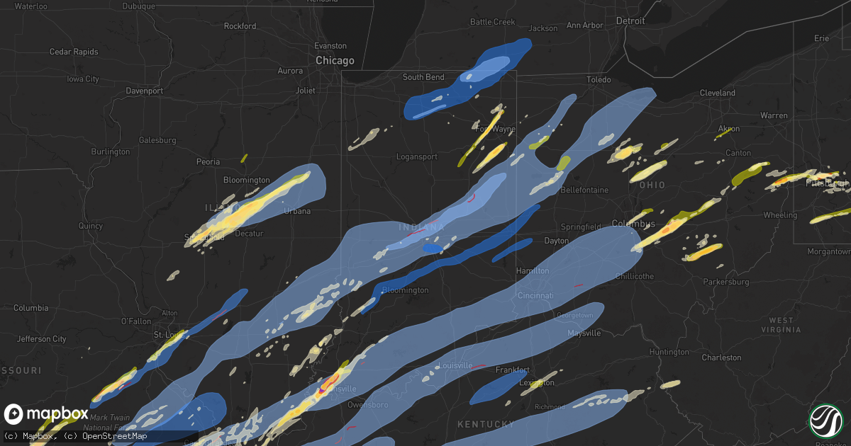
Hail Map in Indiana on April 2, 2025
Get this storm
April 2 map
$229
one time, instant access
Download today. No call, no setup
Keep the $229
Bought the map and want the full workflow? Apply the entire $229 to a subscription within 7 days. None of it is wasted.
Every map, not just this one
This buys you this map. Subscription and you get every map we run, in the markets you choose from a few cities to whole states to nationwide. Plus real-time alerts the moment a storm fires.
Contact data
Name, contact info, occupancy, even credit band for addresses in the footprint. You go from where it hit to who to call.
Become the source they trust
Unlimited branding weather history reports on demand. You already have the documented answer ready for the property owner, and you are the one who showed up with it.
Property data and RoofTrace estimates
Pull up any address you have got, its value and the exact code rules for that jurisdiction, straight from One Click Code. Then RoofTrace estimates the squares, pitch, and roof value, priced the way you price.
Storm reports in Indiana
Indiana
| Date | Description |
|---|---|
| 04/02/20256:56 PM CDT | Tree down onto a garage. Time estimated via radar. |
| 04/02/20256:54 PM CDT | Marshall county remc reports nearly a mile swath of 3 phase power poles and lines down on state road 10 between argos and culver and on the south side of lake max. Time |
| 04/02/20256:54 PM CDT | Roof damage to a barn on in-10 between culver and argos. Photo relayed by abc 57 on facebook. Time estimated via radar. |
| 04/02/20256:52 PM CDT | A survey of damage revealed a tornado touched down southeast of rutland on sr-10 and tracked quickly northeast. The tornado moved over numerous empty fields but also im |
| 04/02/20255:57 PM CDT | Private weather station reported 58 mph gust near brook. |
| 04/02/202510:44 AM CDT | Power lines down along farabee rd near pekin... In. |
| 04/02/20258:58 AM CDT | Utility lines down and sheet metal in roadway at n county rd 600 w & conner rd. Time estimated from radar. |
| 04/02/20257:55 AM CDT | Broadcast media reports quarter size hail in decatur. Time estimated via radar. |
| 04/02/20257:50 AM CDT | Trained spotter reports quarter size hail on sr 1. No damage to homes or cars. |
| 04/02/20257:49 AM CDT | Trees down and powerlines down on the road at the intersection of maplecrest rd and stellhorn rd. |
| 04/02/20257:49 AM CDT | Emergency manager reports golf ball size hail north of bluffton. |
| 04/02/20257:36 AM CDT | Report from mping: quarter |
| 04/02/20257:36 AM CDT | Photo on facebook shows half dollar to ping pong ball at the intersection of garmen rd and tonkel rd. Time estimated via radar. |
| 04/02/20257:35 AM CDT | A local report indicates 1.00 inch wind near 2 E Wallen |
| 04/02/20257:35 AM CDT | Report from mping: quarter |
| 04/02/20257:32 AM CDT | A local report indicates 1.00 inch wind near 4 ESE Huntertown |
| 04/02/20257:32 AM CDT | Report from mping: quarter |
| 04/02/20257:32 AM CDT | Report from mping: quarter |
| 04/02/20257:30 AM CDT | Cocorahs observer measured up to 1 inch hail. |
| 04/02/20257:30 AM CDT | Quarter size hail fell at lima rd and till rd. |
| 04/02/20257:30 AM CDT | A local report indicates 1.00 inch wind near Wallen |
| 04/02/20257:30 AM CDT | Quarter size hail fell at lima rd and till rd. |
| 04/02/20257:28 AM CDT | Nickel to quarter size hail fell for several minutes. |
| 04/02/20257:27 AM CDT | Photo on facebook shows quarter to half dollar size hail that fell in aboite. Time estimated via radar. |
| 04/02/20257:26 AM CDT | A local report indicates 1.00 inch wind near 1 N Rolling Hills |
| 04/02/20257:25 AM CDT | Photo on facebook shows ping pong ball sized hail. Time estimated via radar. |
| 04/02/20257:22 AM CDT | A local report indicates 1.00 inch wind near Fort Wayne |
| 04/02/20257:22 AM CDT | A local report indicates 1.00 inch wind near Fort Wayne |
| 04/01/202510:50 PM CDT | Numerous power poles down and broken near the 4h fairgrounds. |
| 04/01/202510:49 PM CDT | Tree downed along state route 101. Time estimated by radar. |
| 04/01/202510:42 PM CDT | Power lines over road. |
| 04/01/202510:38 PM CDT | Numerous trees snapped... Substantial damage to a barn. |
| 04/01/202510:30 PM CDT | Home damaged on garrison hollow road. |
| 04/01/202510:29 PM CDT | Tree uprooted. |
| 04/01/202510:16 PM CDT | Power line blocking both lanes. |
| 04/01/202510:16 PM CDT | Power pole snapped. |
| 04/01/202510:10 PM CDT | Tree on power line... 190n... Just past sultans run... Tree is completely blocking roadway. |
| 04/01/202510:06 PM CDT | Tree over road. Relayed via social media. |
| 04/01/202510:00 PM CDT | Tree down over road. |
| 04/01/20259:57 PM CDT | Corrects previous tstm wnd dmg report from duff. One main tree branch... 4in diameter... Covering the eastbound lane. |
| 04/01/20259:57 PM CDT | One main tree branch... 4in diameter... Covering the eastbound lane. |
| 04/01/20259:57 PM CDT | An ef-0 tornado with peak winds of 80 mph and a path length of 0.06 miles impacted a rural area southeast of heltonville began at this location. Damage was caused to fa |
| 04/01/20259:50 PM CDT | Damage to barns and out buildings in the area. |
| 04/01/20259:49 PM CDT | Numerous reports of trees down... Damage and debris from storms mainly across eastern part of lawrence co. Time estimated from radar. |
| 04/01/20259:42 PM CDT | Trained spotter reported a large tree downed in berne in adams county in indiana. |
| 04/01/20259:39 PM CDT | Huntingburg airport reporting 62.1 mph wind gust. |
| 04/01/20259:37 PM CDT | Large tree uprooted. Time estimated from radar. |
| 04/01/20259:33 PM CDT | Corrects previous tstm wnd gst report from 3 n johnsburg. Corrects previous tstm wnd gst report from 3 n johnsburg. Huntingburg airport reporting 62.1 mph wind gust. |
| 04/01/20259:33 PM CDT | Power lines and a tree down. |
| 04/01/20259:33 PM CDT | Corrects previous tstm wnd gst report from 3 n johnsburg. Huntingburg airport reporting 62.1 mph wind gust. |
| 04/01/20259:27 PM CDT | Emergency manager reports roof damage to barns... Silos... And machine sheds east of redkey on s cr 325 w. Debris scattered in a nearby field. Time estimated via radar. |
| 04/01/20259:27 PM CDT | Picture of tree over road between greenfield and maxwell on sr9. |
| 04/01/20259:24 PM CDT | Emergency manager reports powerlines down and trees down at 400 s and state road 1 north of redkey. |
| 04/01/20259:23 PM CDT | Tree onto a house near 550 s and 200 w. No injuries reported. Time estimated by radar. |
| 04/01/20259:22 PM CDT | Semi overturned. |
| 04/01/20259:18 PM CDT | Picture of large tree limb over the road. |
| 04/01/20259:15 PM CDT | A local report indicates 62 MPH wind near Dunkirk |
| 04/01/20259:15 PM CDT | Minor roof damage to homes. Time estimated from radar. |
| 04/01/20259:14 PM CDT | House damaged. |
| 04/01/20259:14 PM CDT | Multiple trees downed. |
| 04/01/20259:13 PM CDT | Personal weather station kineaton8 1 mile south of eaton... Indiana gusted to 100 mph from a thunderstorm at 10:13 pm edt. |
| 04/01/20259:10 PM CDT | Tree down near 5th and broadway. Time very roughly estimated from radar. |
| 04/01/20259:10 PM CDT | Report of roof damage... With water entering the structure... On morre st. Between 7th st and forrest ave. In boonville... In. |
| 04/01/20259:10 PM CDT | Part of roof blown off of a house and laying in the front yard near millersburg rd and n eskew rd... Boonville... In. Possible tornado. |
| 04/01/20259:09 PM CDT | Trees across road near hindostan. Time estimated from radar. |
| 04/01/20259:08 PM CDT | Law enforcement reports of a large tree downed near mill grove in blackford county in indiana. Time is radar estimated. |
| 04/01/20259:06 PM CDT | Law enforcement reported a tree had fallen on a house near mill grove in blackford county in indiana. Time is radar estimated. Injuries/fatalities are unknown at this t |
| 04/01/20259:06 PM CDT | *** 1 inj *** corrects previous tstm wnd dmg report from 1 wsw mill grove. Law enforcement reported a barn was blown into a house near mill grove in blackford county in |
| 04/01/20259:06 PM CDT | Asos station kmie muncie. |
| 04/01/20259:05 PM CDT | Report of a home with serious damage on cr 400 e between cr 300 s and cr 400 s. Time estimated from radar. |
| 04/01/20259:05 PM CDT | A local report indicates 63 MPH wind near 1 ENE Newburgh |
| 04/01/20259:03 PM CDT | Roof blown off a house by thunderstorm winds. Time estimated from radar. |
| 04/01/20259:03 PM CDT | A local report indicates 63 MPH wind near 2 NW Newburgh |
| 04/01/20259:03 PM CDT | Time approximated from radar. Location is approximate. ^00 west is shut down due to utility poles in the roadway. |
| 04/01/20259:03 PM CDT | Asos station kevv evansville in. |
| 04/01/20259:02 PM CDT | Tree and power lines down. |
| 04/01/20259:02 PM CDT | Several windows broken in dormitories at ball state university. Time estimated from radar. |
| 04/01/20259:01 PM CDT | Transformer damage reported. |
| 04/01/20258:58 PM CDT | Corrects previous tstm wnd dmg report from 4 s gaston. Utility lines down and sheet metal in roadway at n county rd 600 w & conner rd. Time estimated from radar. |
| 04/01/20258:58 PM CDT | Trees and powerlines down in area. |
| 04/01/20258:52 PM CDT | Delayed report. Tree down. |
| 04/01/20258:52 PM CDT | A local report indicates 79 MPH wind near 3 NNW River Forest |
| 04/01/20258:49 PM CDT | Numerous trees down... Including a very large one on highland court. |
| 04/01/20258:47 PM CDT | Multiple trees downed. |
| 04/01/20258:42 PM CDT | Plethora of damage to homes and businesses... Many roads impassable from large amounts of debris. |
| 04/01/20258:39 PM CDT | Time estimated from radar. |
| 04/01/20258:38 PM CDT | Trees and power lines down. |
| 04/01/20258:35 PM CDT | Thunderstorm winds were measured at 87 mph north of lapel. Time estimated from radar. Location estimated. |
| 04/01/20258:35 PM CDT | Reports of downed powerlines in the area from storms. |
| 04/01/20258:34 PM CDT | Power lines taken down near 3rd/broadway in oaktown. |
| 04/01/20258:30 PM CDT | Delayed report. Trees down. |
| 04/01/20258:30 PM CDT | Traffic signal was blown down into the intersection at west 86th street and harcourt road. Live electric line. Time estimated from radar. |
| 04/01/20258:30 PM CDT | Tree down with power lines. Time very roughly estimated from radar. |
| 04/01/20258:30 PM CDT | Unknown number of tree branches down. Winds shaking house considerably. Time estimated from radar. |
| 04/01/20258:30 PM CDT | Side of carmel old town antique mall building peeled off by thunderstorm winds. Time estimated from radar. |
| 04/01/20258:30 PM CDT | Report from mping: quarter |
| 04/01/20258:30 PM CDT | Furniture blown... Large limbs and tree tops down from thunderstorm winds. Time estimated from radar. |
| 04/01/20258:30 PM CDT | Aluminum siding blown off a house and a 12-inch diameter tree was split in half...suspected lightning strike. Time estimated from radar. |
| 04/01/20258:30 PM CDT | A local report indicates 1.00 inch wind near 3 ESE Beech Grove |
| 04/01/20258:26 PM CDT | Building damage and large tree limbs broken. Time estimated from radar. |
| 04/01/20258:26 PM CDT | Reports of debris and damage within carmel. Trees and powerlines down and roads flooded. |
| 04/01/20258:25 PM CDT | Per indianapolis dispatch center... We have at least 6 different incidents with trees into homes/buildings. Locations in the indianapolis area are unknown at this time. |
| 04/01/20258:20 PM CDT | Large tree down into a street from thunderstorm winds. Time estimated from radar. |
| 04/01/20258:18 PM CDT | A local report indicates 65 MPH wind near Indianapolis Intl Airp |
| 04/01/20258:18 PM CDT | A local report indicates 65 MPH wind near Indianapolis Int'l Airp |
| 04/01/20258:18 PM CDT | A local report indicates 65 MPH wind near 2 SSE Vincennes |
| 04/01/20258:18 PM CDT | Power poles snapped and along lafayette rd. One landed on a car. Sheet metal in road and in powerlines. Semi flipped on side nearby. Time estimated from radar. |
| 04/01/20258:15 PM CDT | A local report indicates 81 MPH wind near 3 ESE Danville |
| 04/01/20258:15 PM CDT | A local report indicates 60 MPH wind near Bruceville |
| 04/01/20258:15 PM CDT | At least a dozen trees down in the area. |
| 04/01/20258:15 PM CDT | Report of tree on house nearby. Time estimated from radar. |
| 04/01/20258:15 PM CDT | A local report indicates 70 MPH wind near Monrovia |
| 04/01/20258:14 PM CDT | Damage in branches subdivision neighborhood in brownsburg. |
| 04/01/20258:13 PM CDT | Location described as northeast of danville. Two reports of 70 mph thunderstorm winds. |
| 04/01/20258:11 PM CDT | Housing development damaged. Time estimated from radar. |
| 04/01/20258:10 PM CDT | Trees down and possibly other damage from thunderstorm winds along east county road 600 north between north raceway road and ronald regan parkway. Time estimated from r |
| 04/01/20258:10 PM CDT | Structure collapse with a few people unaccounted for. Time estimated from radar.... |
| 04/01/20258:10 PM CDT | Damage to hession farms inc. Time estimated from radar. |
| 04/01/20257:58 PM CDT | Delayed report. Barn blown 80 yards downstream. |
| 04/01/20257:55 PM CDT | Awos station kcfj crawfordsville. |
| 04/01/20257:50 PM CDT | Cup anemometer at 33 feet. |
| 04/01/20257:48 PM CDT | A local report indicates 63 MPH wind near 4 S Delphi |
| 04/01/20257:48 PM CDT | Trained spotter reports an estimated wind gust of 98.4 mph using an anemometer. |
| 04/01/20257:48 PM CDT | Damage reported to a barn and a home on st rd 120. Time estimated via radar. |
| 04/01/20257:48 PM CDT | Emergency manager reports 1 injury at 6060 market street in orland. Roof lost on a 1 story assisted living building. Insulation and debris strewn in nearby fields and i |
| 04/01/20257:48 PM CDT | Emergency manager reports a barn with structural damage to the roof at 7640 n 750 w ij orland. Time estimated via radar. |
| 04/01/20257:37 PM CDT | Lagrange county sheriffs office reports leaning/downed power lines on sr 120 between cr 110 e and cr 900 e. Time estimated via radar. |
| 04/01/20257:33 PM CDT | Corrects previous non-tstm wnd gst report from vincennes. |
| 04/01/20257:30 PM CDT | Multiple trees down onto powerlines at the intersection of st rd 120 and 900 west. Time estimated via radar. |
| 04/01/20257:30 PM CDT | Thunderstorm winds caused large oak tree to collapse on powerline... Causing power outage. Time estimated from radar. |
| 04/01/20257:25 PM CDT | Tree and power lines down onto a vehicle across n. Hillside drive. Time estimated via radar. |
| 04/01/20257:24 PM CDT | An ef-1 tornado with peak winds of 105 mph and a path length of 8.55 miles began in a rural field just east of numa... In. Damage was caused to a home and a few structu |
| 04/01/20257:24 PM CDT | Goshen airport is without power. Estimated 70+ mph winds. |
| 04/01/20257:23 PM CDT | Numerous tree damage in the area. |
| 04/01/20257:15 PM CDT | Home significantly damaged. Reports of tree damage as well. Power out across town from wind damage. |
| 04/01/20257:14 PM CDT | An ef-1 tornado with peak winds of 110 mph and a path length of 4.45 miles began right at the il/in state line and tracked ene toward west new goshen. The tornado then |
| 04/01/20257:13 PM CDT | Report of structure damage. Time estimated from radar. |
| 04/01/20257:10 PM CDT | Three semi-trucks were overturned by thunderstorm winds near the indiana-illinois state border. |
| 04/01/20257:09 PM CDT | Powerlines down on sr19 near 600 north. Time estimated via radar. |
| 04/01/20257:05 PM CDT | Substantial damage to a home in bourbon. Garage is completely gone and part of home has severe structural damage. Time estimated via radar. |
| 04/01/20257:05 PM CDT | Us 30 was closed for several hours on the evening of april 2nd after at least 3 semis flipped over at the intersection with cedar rd north of bourbon. Unknown if there |
| 04/01/20257:05 PM CDT | News now warsaw relays report of a woman trapped in her car after a tree fell on it. Unknown the extent of any injuries. Time estimated via radar. |
| 04/01/20257:05 PM CDT | Marshall county remc reports over 20 broken poles along 12th rd between cedar rd and beech rd. Time estimated via radar. |
| 04/01/20257:04 PM CDT | Abc 57 in south bend relays report that 3 semis tipped over on us 30 in bourbon. Parts of us 30 are closed. Unknown if any injuries. Time estimated via radar. |
| 04/01/20257:04 PM CDT | Emergency manager confirms multiple houses with roofs off on rose ln and crocut ct in bourbon. Time estimated via radar. |
| 04/01/20257:04 PM CDT | Roof gone and structural damage to the bourbon township trustee building at the intersection of center street and n washington street. Relayed by abc 57. Time estimated |
| 04/01/20257:04 PM CDT | Structural damage reported to a house on the east side of bourbon. Time estimated via radar. |
| 04/01/20257:03 PM CDT | Photo relayed by wsbt of damage to northern indiana manufacturing inc. The factory is at the intersection of s ecker avenue and w quad street. Time estimated via radar. |
| 04/01/20257:03 PM CDT | Photo relayed by wsbt in south bend of damage to the northern indiana manufacturing factory in bourbon. Factory is at the intersection of w quad street and s ecker aven |
| 04/01/20257:01 PM CDT | Emergency manager relayed a report of a tree down on hawthorne lane in logansport. Time estimated via radar. |
| 04/01/20257:00 PM CDT | Lots of damage reported east of argos... In on sr 10 including trees down onto powerlines and large trees limbs snapped. |
All States Impacted by Hail Map on April 2, 2025
Cities Impacted by Hail Map on April 2, 2025
- Butler, MO
- Urich, MO
- Montrose, MO
- Clinton, MO
- Ada, OK
- Sasakwa, OK
- Holdenville, OK
- Roff, OK
- Fitzhugh, OK
- Broken Arrow, OK
- Bixby, OK
- Davis, OK
- La Fontaine, IN
- Marion, IN
- Wabash, IN
- Andrews, IN
- Huntington, IN
- Roanoke, IN
- Fort Wayne, IN
- Moundville, MO
- Calvin, OK
- Pittsburg, KS
- Stonewall, OK
- Fittstown, OK
- Coweta, OK
- Sulphur, OK
- Stratford, OK
- Leo, IN
- Huntertown, IN
- Auburn, IN
- Spencerville, IN
- Bluffton, IN
- Allen, OK
- Tupelo, OK
- Liberty Center, IN
- Nocona, TX
- Saint Jo, TX
- Poneto, IN
- Warren, IN
- Lamar, OK
- Montpelier, IN
- Craigville, IN
- Wagoner, OK
- Ossian, IN
- Decatur, IN
- Centrahoma, OK
- Leon, OK
- Burneyville, OK
- Rossburg, OH
- New Weston, OH
- Hanna, OK
- Yorkshire, OH
- Botkins, OH
- Fort Loramie, OH
- New Bremen, OH
- Minster, OH
- Anna, OH
- Osgood, OH
- New Knoxville, OH
- Maria Stein, OH
- Coalgate, OK
- Eufaula, OK
- Van Wert, OH
- Middle Point, OH
- Delphos, OH
- Fort Jennings, OH
- Markle, IN
- Madill, OK
- Wardville, OK
- Wapakoneta, OH
- Rockford, OH
- Berne, IN
- Monroe, IN
- Willshire, OH
- Ohio City, OH
- Antwerp, OH
- Cecil, OH
- Cloverdale, OH
- El Dorado Springs, MO
- Pilot Grove, MO
- Boonville, MO
- Red Oak, OK
- Milburn, OK
- Tishomingo, OK
- Lima, OH
- Uniopolis, OH
- Harrod, OH
- Blairstown, MO
- Continental, OH
- Wapanucka, OK
- Coleman, OK
- Morral, OH
- La Rue, OH
- Harpster, OH
- Upper Sandusky, OH
- Nevada, OH
- Bucyrus, OH
- Monroeville, IN
- Cardington, OH
- Ashley, OH
- Waldo, OH
- Marion, OH
- Circleville, OH
- Mount Blanchard, OH
- Vanlue, OH
- Wharton, OH
- Carey, OH
- Mount Gilead, OH
- Edison, OH
- Mansfield, OH
- Fredericktown, OH
- Bellville, OH
- Wilburton, OK
- Columbus, OH
- Ashville, OH
- Lockbourne, OH
- Lancaster, OH
- Amanda, OH
- Carroll, OH
- Canal Winchester, OH
- New Riegel, OH
- Van Buren, IN
- New Albany, OH
- Westerville, OH
- Leipsic, OH
- Garrett, IN
- Laotto, IN
- Wister, OK
- Thurston, OH
- Baltimore, OH
- Pleasantville, OH
- Millersport, OH
- Thornville, OH
- Buckeye Lake, OH
- Johnstown, OH
- Cameron, OK
- Crestline, OH
- Galion, OH
- Poteau, OK
- Shady Point, OK
- Pickerington, OH
- Reynoldsburg, OH
- Glouster, OH
- Nelsonville, OH
- Murray City, OH
- Heath, OH
- Glenford, OH
- New Straitsville, OH
- Shawnee, OH
- Hebron, OH
- Hopewell, OH
- Mount Perry, OH
- Grove City, OH
- Jacksontown, OH
- Newark, OH
- Nashport, OH
- Frazeysburg, OH
- Dresden, OH
- Zanesville, OH
- Conesville, OH
- Coshocton, OH
- Adamsville, OH
- Corning, OH
- Malta, OH
- Chesterhill, OH
- Mcconnelsville, OH
- Stockport, OH
- Beverly, OH
- Greenwich, OH
- Shelby, OH
- Shiloh, OH
- Ashland, OH
- Pocola, OK
- Hackett, AR
- Fort Smith, AR
- Springdale, AR
- Caledonia, OH
- Granville, OH
- Alexandria, OH
- McCutchenville, OH
- Plainfield, OH
- West Lafayette, OH
- Bloomville, OH
- Sycamore, OH
- Rogers, AR
- Hindsville, AR
- Lowell, AR
- Caldwell, OH
- Newcomerstown, OH
- New Lexington, OH
- Crooksville, OH
- Roseville, OH
- Vincent, OH
- Waterford, OH
- Fleming, OH
- Oark, AR
- Blue Rock, OH
- New Philadelphia, OH
- Midvale, OH
- Dennison, OH
- Uhrichsville, OH
- Gnadenhutten, OH
- Sherrodsville, OH
- Dover, OH
- Mineral City, OH
- Dellroy, OH
- Magnolia, OH
- Bowerston, OH
- Carrollton, OH
- Ratcliff, AR
- Tuscarawas, OH
- Deer, AR
- Ozark, AR
- Port Washington, OH
- Altus, AR
- Clarksville, AR
- Paris, AR
- Wooster, OH
- Shreve, OH
- Big Prairie, OH
- Smithville, OK
- Fredericksburg, OH
- Apple Creek, OH
- Minerva, OH
- Mechanicstown, OH
- Salineville, OH
- Kensington, OH
- Brewster, OH
- Dundee, OH
- Navarre, OH
- Summitville, OH
- Marshallville, OH
- Rittman, OH
- Doylestown, OH
- Barberton, OH
- Richmond, OH
- Bloomingdale, OH
- Steubenville, OH
- Hopedale, OH
- Toronto, OH
- Irondale, OH
- New Cumberland, WV
- Empire, OH
- Georgetown, PA
- Hookstown, PA
- Fort Towson, OK
- Sycamore, PA
- Graysville, PA
- Hugo, OK
- Grant, OK
- Weirton, WV
- Jewett, OH
- Mena, AR
- Sawyer, OK
- Arthur City, TX
- Powderly, TX
- Prosperity, PA
- Waynesburg, PA
- Amity, PA
- Marianna, PA
- Fredericktown, PA
- Clarksville, PA
- Brownsville, PA
- Scenery Hill, PA
- Beallsville, PA
- Richeyville, PA
- Daisytown, PA
- California, PA
- Fayette City, PA
- Coal Center, PA
- Newell, PA
- Star Junction, PA
- Allenport, PA
- Elco, PA
- Perryopolis, PA
- Grindstone, PA
- Roscoe, PA
- Stockdale, PA
- Huntington, AR
- Greenwood, AR
- Mansfield, AR
- Booneville, AR
- Lavaca, AR
- Charleston, AR
- Clinton, PA
- Aliquippa, PA
- South Heights, PA
- Burgettstown, PA
- Stratton, OH
- Coraopolis, PA
- Dawson, PA
- Scottdale, PA
- Smithton, PA
- Alverton, PA
- Ruffs Dale, PA
- Pittsburgh, PA
- Sewickley, PA
- McKees Rocks, PA
- Ava, MO
- Parthenon, AR
- Mansfield, MO
- Vestaburg, PA
- Ambridge, PA
- Lavon, TX
- Nevada, TX
- Glenshaw, PA
- Cedarcreek, MO
- Farmersville, TX
- Branch, AR
- Royse City, TX
- Rockwall, TX
- Imperial, PA
- Allison Park, PA
- Cheswick, PA
- Indianola, PA
- Tarentum, PA
- Macomb, MO
- Norwood, MO
- Mountain Grove, MO
- Bradleyville, MO
- Oakmont, PA
- Harrison, AR
- Jasper, AR
- Monroeville, PA
- Kissee Mills, MO
- Rueter, MO
- Hartville, MO
- Seymour, MO
- Yellville, AR
- Gibsonia, PA
- Cecil, AR
- Thornfield, MO
- New Kensington, PA
- Verona, PA
- Squires, MO
- Bethel Park, PA
- Cuddy, PA
- McDonald, PA
- Oakdale, PA
- Bridgeville, PA
- Morgan, PA
- Bergholz, OH
- Hammondsville, OH
- Leetsdale, PA
- Crescent, PA
- Mountain Home, AR
- Oakland, AR
- Lakeview, AR
- Midway, AR
- Gainesville, MO
- Huggins, MO
- Graff, MO
- Cabool, MO
- Success, MO
- Bucyrus, MO
- Plato, MO
- Heavener, OK
- Western Grove, AR
- Hasty, AR
- Export, PA
- Murrysville, PA
- Turtle Creek, PA
- Pitcairn, PA
- East Pittsburgh, PA
- Trafford, PA
- Irwin, PA
- Duquesne, PA
- Mckeesport, PA
- Braddock, PA
- North Versailles, PA
- Homestead, PA
- Wilmerding, PA
- East McKeesport, PA
- West Mifflin, PA
- Clairton, PA
- Dravosburg, PA
- Everton, AR
- Saint Joe, AR
- Valley Springs, AR
- Flippin, AR
- Houston, MO
- Licking, MO
- Gassville, AR
- Cotter, AR
- New Alexandria, PA
- Greensburg, PA
- Latrobe, PA
- Ardara, PA
- Pettigrew, AR
- Harrison City, PA
- Jeannette, PA
- Westmoreland City, PA
- Claridge, PA
- Manor, PA
- Tecumseh, MO
- Hardenville, MO
- Wright City, OK
- Valliant, OK
- Dardanelle, AR
- Forbes Road, PA
- Summit, AR
- Lenox, MO
- Salem, MO
- Ligonier, PA
- Bolivar, PA
- New Florence, PA
- Roby, MO
- Kingston, AR
- Huntsville, AR
- Berryville, AR
- Johnstown, PA
- Green Forest, AR
- Compton, AR
- Alpena, AR
- Bull Shoals, AR
- Dover, AR
- Talihina, OK
- Pyatt, AR
- Peel, AR
- Saltsburg, PA
- Ponca, AR
- Stuart, OK
- Bethel, OK
- Hannastown, PA
- Crabtree, PA
- Waldron, AR
- Hartman, AR
- Derry, PA
- Laughlintown, PA
- Rector, PA
- Boswell, PA
- Broken Bow, OK
- Omaha, AR
- South Fork, PA
- Kirbyville, MO
- Hollister, MO
- Olive Branch, MS
- Memphis, TN
- Collierville, TN
- Pomona, MO
- West Plains, MO
- Caulfield, MO
- Pottersville, MO
- Pelsor, AR
- Gamaliel, AR
- Havana, AR
- Bakersfield, MO
- Clarkridge, AR
- Henderson, AR
- Udall, MO
- New Blaine, AR
- Cherryville, MO
- Delaware, AR
- Belleville, AR
- Gepp, AR
- Duke, MO
- Edgar Springs, MO
- Newburg, MO
- New Berlin, IL
- Watson, OK
- Cove, AR
- Hatfield, AR
- Dora, MO
- Danville, AR
- Drury, MO
- Magazine, AR
- Vendor, AR
- Davidsville, PA
- Wesco, MO
- Steelville, MO
- Springfield, IL
- Moody, MO
- Riverton, IL
- Sherman, IL
- London, AR
- Russellville, AR
- Pottsville, AR
- Oakland, TN
- Somerville, TN
- Crawfordsville, AR
- Paris, TX
- Vanderbilt, PA
- Pleasant Plains, IL
- Mountain View, MO
- New Enterprise, PA
- Woodbury, PA
- Owensville, MO
- Cantrall, IL
- Loami, IL
- Eminence, MO
- Pindall, AR
- Eads, TN
- Helena, AR
- Byhalia, MS
- Germantown, TN
- Rossville, TN
- Moscow, TN
- Williston, TN
- Bourbon, MO
- Potosi, MO
- Blue Springs, MS
- Tupelo, MS
- Saltillo, MS
- Guntown, MS
- Baldwyn, MS
- Davisville, MO
- Richwoods, MO
- Sullivan, MO
- Peace Valley, MO
- Birch Tree, MO
- Batesville, MS
- Williamsville, IL
- Clarksdale, MS
- Turrell, AR
- Marion, AR
- Detroit, TX
- Blossom, TX
- Mount Pulaski, IL
- Athens, IL
- Elkhart, IL
- Cadet, MO
- Blackwell, MO
- Lincoln, IL
- Chestnut, IL
- Beason, IL
- Middletown, IL
- Buffalo, IL
- Mason, TN
- Stanton, TN
- Fletcher, MO
- Dittmer, MO
- De Soto, MO
- Booneville, MS
- Fulton, MS
- Mantachie, MS
- Clinton, IL
- Wapella, IL
- Kenney, IL
- Waynesville, IL
- Latham, IL
- Maroa, IL
- Nettleton, MS
- Lyon, MS
- Charleston, MS
- Tutwiler, MS
- Hettick, IL
- Hernando, MS
- Lawndale, IL
- Atlanta, IL
- Coahoma, MS
- Plantersville, MS
- Greenfield, IL
- Millington, TN
- Drummonds, TN
- Rockbridge, IL
- Sardis, MS
- Hillsboro, MO
- Harriet, AR
- Burlison, TN
- Henning, TN
- Golden, MS
- Earle, AR
- Covington, TN
- Whiteville, TN
- Coldwater, MS
- Senatobia, MS
- Como, MS
- Willow Springs, MO
- Palmyra, IL
- Ellington, MO
- Marks, MS
- Chatham, IL
- Rienzi, MS
- Weldon, IL
- Dewitt, IL
- Farmer City, IL
- Dierks, AR
- Newhope, AR
- Belmont, MS
- Langley, AR
- Kirby, AR
- Dennis, MS
- Glenwood, AR
- Caddo Gap, AR
- Ripley, TN
- McLean, IL
- Spearsville, LA
- Rochester, IL
- Sledge, MS
- Barnhart, MO
- Dawson, IL
- Lesterville, MO
- Chesterfield, IL
- Mercer, TN
- Imperial, MO
- Courtland, MS
- Atoka, TN
- Holly Springs, MS
- Lane, IL
- Le Roy, IL
- Arrowsmith, IL
- Bellflower, IL
- Denmark, TN
- Jackson, TN
- New Site, MS
- Nashville, GA
- Alapaha, GA
- Willacoochee, GA
- Crenshaw, MS
- Sarah, MS
- Annapolis, MO
- Arcadia, MO
- Ironton, MO
- Munford, TN
- Brighton, TN
- Mechanicsburg, IL
- Auburn, IL
- Divernon, IL
- Glenarm, IL
- Pevely, MO
- Arnold, MO
- Columbia, IL
- Saint Louis, MO
- Heyworth, IL
- Illiopolis, IL
- Red Banks, MS
- Warrensburg, IL
- Decatur, IL
- Niantic, IL
- Norman, AR
- Oreana, IL
- Argenta, IL
- Forsyth, IL
- Bonnerdale, AR
- Saybrook, IL
- Foosland, IL
- Gibson City, IL
- Paxton, IL
- Mount Ida, AR
- Melvin, IL
- Elliott, IL
- Cisco, IL
- Redford, MO
- Centerville, MO
- Fredericktown, MO
- Wray, GA
- Brownsville, TN
- Farmington, MO
- Doe Run, MO
- Pawnee, IL
- Cherokee, AL
- Marietta, MS
- Tishomingo, MS
- East Carondelet, IL
- Gates, TN
- Mansfield, IL
- Belleville, IL
- Dupo, IL
- Millstadt, IL
- East Saint Louis, IL
- Halls, TN
- Fisher, IL
- Black, MO
- Vulcan, MO
- Rison, AR
- Middle Brook, MO
- Pilot Knob, MO
- Belleview, MO
- Bismarck, MO
- Park Hills, MO
- Sainte Genevieve, MO
- Bonne Terre, MO
- Perryville, MO
- Bloomsdale, MO
- Saint Mary, MO
- Modoc, IL
- Prairie Du Rocher, IL
- Evansville, IL
- Wilmar, AR
- Festus, MO
- Crystal City, MO
- Herculaneum, MO
- Valmeyer, IL
- Waterloo, IL
- Caseyville, IL
- Fairview Heights, IL
- O'Fallon, IL
- Lebanon, IL
- Collinsville, IL
- Highland, IL
- Saint Jacob, IL
- Troy, IL
- Trenton, IL
- Star City, AR
- Ambrose, GA
- Ocilla, GA
- Loda, IL
- Oakfield, TN
- Medina, TN
- De Land, IL
- Monticello, IL
- White Heath, IL
- Nesbit, MS
- Plainview, AR
- Winona, MO
- Mountain View, AR
- Warren, AR
- Red Bay, AL
- Briggsville, AR
- Rover, AR
- Ola, AR
- Perryville, AR
- Casa, AR
- Adona, AR
- Perry, AR
- Morrilton, AR
- Greenville, IL
- Pocahontas, IL
- Ellis Grove, IL
- Baldwin, IL
- Walsh, IL
- Chester, IL
- Sparta, IL
- Marissa, IL
- Houston, AR
- Bigelow, AR
- Mahomet, IL
- Seymour, IL
- Plumerville, AR
- Conway, AR
- Mayflower, AR
- Dewey, IL
- Champaign, IL
- Yorktown, AR
- Couch, MO
- Cedar Grove, TN
- Lexington, TN
- Alton, MO
- Milan, TN
- Lavinia, TN
- Bondville, IL
- Urbana, IL
- Doniphan, MO
- Fremont, MO
- Anchor, IL
- Sibley, IL
- Thomasboro, IL
- Rantoul, IL
- Haughton, LA
- Bossier City, LA
- Searcy, AR
- Batesville, AR
- Marcella, AR
- Pleasant Grove, AR
- Romance, AR
- Sherwood, AR
- Little Rock, AR
- North Little Rock, AR
- Beech Bluff, TN
- Buckley, IL
- Iuka, MS
- Gould, AR
- Grady, AR
- Ludlow, IL
- Gifford, IL
- Chatsworth, IL
- Gilman, IL
- Onarga, IL
- Roberts, IL
- Thawville, IL
- Smithboro, IL
- Penfield, IL
- Ogden, IL
- Armstrong, IL
- Cissna Park, IL
- Saint Joseph, IL
- Potomac, IL
- Rankin, IL
- Lamar, MS
- Okawville, IL
- Tilden, IL
- Oakdale, IL
- Coulterville, IL
- Addieville, IL
- Steeleville, IL
- Percy, IL
- Nashville, IL
- Cutler, IL
- Collison, IL
- Cordova, TN
- Arlington, TN
- Millen, GA
- Cabot, AR
- Michigan City, MS
- Grand Junction, TN
- La Grange, TN
- Midville, GA
- Garfield, GA
- Twin City, GA
- De Valls Bluff, AR
- Hazen, AR
- Jacksonville, AR
- Maumelle, AR
- Friars Point, MS
- Yuma, TN
- Huntingdon, TN
- Little Rock Air Force Base, AR
- Longview, TX
- Pangburn, AR
- Letona, AR
- Carlisle, AR
- Stuttgart, AR
- Biscoe, AR
- Princeton, LA
- Barksdale Afb, LA
- Jefferson, TX
- Harleton, TX
- Southaven, MS
- Van Buren, MO
- Poplar Bluff, MO
- Grandin, MO
- Ellsinore, MO
- Dundee, MS
- Rossville, IL
- Hoopeston, IL
- Austin, AR
- Ward, AR
- Des Arc, AR
- Beebe, AR
- Tunica, MS
- Cotton Plant, AR
- Florence, AL
- Waterloo, AL
- McRae, AR
- Diana, TX
- Black Rock, AR
- Smithville, AR
- Buena Vista, TN
- Westport, TN
- Monticello, AR
- Altheimer, AR
- De Witt, AR
- Bruceton, TN
- Lonoke, AR
- Burns, TN
- White Bluff, TN
- Haleyville, AL
- Clarks Hill, SC
- Keyesport, IL
- Ravenden, AR
- Imboden, AR
- Malvern, AR
- Lonsdale, AR
- Benton, AR
- Judsonia, AR
- Bald Knob, AR
- Bradford, AR
- Hallsville, TX
- Evening Shade, AR
- Poughkeepsie, AR
- Williford, AR
- Hickory Valley, TN
- Horn Lake, MS
- Williamsville, MO
- Mill Spring, MO
- Camden, TN
- Holladay, TN
- Wildersville, TN
- Hollow Rock, TN
- Mulberry Grove, IL
- Fillmore, IL
- Ramsey, IL
- Bingham, IL
- Vandalia, IL
- Hoyleton, IL
- Carlyle, IL
- Bartelso, IL
- Hoffman, IL
- Patoka, IL
- Centralia, IL
- Richview, IL
- Sandoval, IL
- Irvington, IL
- Ashley, IL
- Waynesboro, GA
- Lewisburg, TN
- Columbia, TN
- Chapel Hill, TN
- College Grove, TN
- Eagleville, TN
- Ashland City, TN
- Almyra, AR
- Bolivar, TN
- Logansport, LA
- Portia, AR
- Camden, AR
- Gloster, LA
- Grand Cane, LA
- San Augustine, TX
- Sparkman, AR
- Zavalla, TX
- Newport, AR
- Sheridan, AR
- Alicia, AR
- Etoile, TX
- Thida, AR
- Kensett, AR
- Huntington, TX
- Wappapello, MO
- Naylor, MO
- Chester, TX
- Cotton Valley, LA
- Oxly, MO
- Greenville, MO
- Stonewall, LA
- Patton, MO
- Redfield, AR
- Emerson, AR
- Rockwood, IL
- Swifton, AR
- Stephens, AR
- Shongaloo, LA
- Lowndes, MO
- Pocahontas, AR
- Marquand, MO
- Frierson, LA
- Campbell Hill, IL
- Carthage, AR
- Fairdealing, MO
- Magnolia, AR
- Cord, AR
- England, AR
- Higginson, AR
- Success, AR
- Harviell, MO
- Hoxie, AR
- Minden, LA
- Maynard, AR
- Marble Hill, MO
- Newark, AR
- Bearden, AR
- Pinckneyville, IL
- Sedgewickville, MO
- Garner, AR
- Shreveport, LA
- Glenallen, MO
- Walnut Ridge, AR
- Hensley, AR
- Oil Trough, AR
- Shelbyville, TX
- Center, TX
- Scott, AR
- Dukedom, TN
- De Soto, IL
- Palmersville, TN
- McKenzie, TN
- Sardis, TN
- Karnak, IL
- Grand Chain, IL
- Cunningham, KY
- Tamaroa, IL
- Makanda, IL
- Paducah, KY
- Carbondale, IL
- Buncombe, IL
- Scotts Hill, TN
- Phil Campbell, AL
- Bardwell, KY
- Reagan, TN
- Hackleburg, AL
- Gleason, TN
- Vienna, IL
- Russellville, AL
- Fancy Farm, KY
- Fulton, KY
- Goreville, IL
- Savannah, TN
- Morris Chapel, TN
- Saltillo, TN
- Bear Creek, AL
- Hickory, KY
- Wingo, KY
- Mayfield, KY
- Dresden, TN
- Du Quoin, IL
- Kevil, KY
- Cypress, IL
- Elkville, IL
- Sedalia, KY
- Carterville, IL
- Belknap, IL
- Spruce Pine, AL
- Hornbeak, TN
- Vergennes, IL
- Alto Pass, IL
- Obion, TN
- Union City, TN
- Cairo, IL
- Pomona, IL
- Murphysboro, IL
- Ashland, MS
- Bells, TN
- Dyersburg, TN
- Jonesboro, IL
- Friendship, TN
- Charleston, MO
- Cobden, IL
- Thebes, IL
- Troy, TN
- Tamms, IL
- Hickman, KY
- Newbern, TN
- Alamo, TN
- East Prairie, MO
- Broseley, MO
- Fisher, AR
- Wheatley, AR
- Oak Ridge, MO
- Frohna, MO
- Friedheim, MO
- Hickory Ridge, AR
- Rector, AR
- Paragould, AR
- Ava, IL
- Farrar, MO
- Fisk, MO
- State University, AR
- Lafe, AR
- Zalma, MO
- Daisy, MO
- Uniontown, MO
- Brinkley, AR
- Clarendon, AR
- Corning, AR
- Leopold, MO
- Puxico, MO
- Qulin, MO
- Millersville, MO
- Cherry Valley, AR
- Marmaduke, AR
- Jonesboro, AR
- Wynne, AR
- Sturdivant, MO
- Pollard, AR
- Dudley, MO
- Robinsonville, MS
- Ulm, AR
- Avinger, TX
- Griffithville, AR
- McCrory, AR
- Pleasant Plains, AR
- Linden, TX
- Alexander, AR
- Ravenden Springs, AR
- Hardy, AR
- Salem, IL
- Odin, IL
- Alma, IL
- Walnut Hill, IL
- Woodlawn, IL
- Kell, IL
- Iuka, IL
- Dix, IL
- Mount Vernon, IL
- Texico, IL
- Mount Hope, AL
- Moulton, AL
- Casscoe, AR
- Big Sandy, TN
- Eva, TN
- Waverly, TN
- Joelton, TN
- Pleasant View, TN
- Wickliffe, KY
- Toone, TN
- Medon, TN
- Piedmont, MO
- Des Arc, MO
- Patterson, MO
- Silva, MO
- Lodi, MO
- Morocco, IN
- Brook, IN
- Brilliant, AL
- Lake Cormorant, MS
- Walls, MS
- Kingston Springs, TN
- Culleoka, TN
- Kentland, IN
- Rensselaer, IN
- Weiner, AR
- Biggers, AR
- Villa Ridge, IL
- Mound City, IL
- Olmsted, IL
- Mounds, IL
- Cypress Inn, TN
- Lutts, TN
- El Paso, AR
- Hunter, AR
- Colt, AR
- Bivins, TX
- Vilonia, AR
- Jackson, MO
- Gipsy, MO
- McGee, MO
- Springfield, TN
- Goodlettsville, TN
- Greenbrier, TN
- Pinson, TN
- Edgewood, IL
- Farina, IL
- Kinmundy, IL
- Xenia, IL
- Mason, IL
- Louisville, IL
- Dieterich, IL
- Flora, IL
- Rinard, IL
- Johnsonville, IL
- Holly Grove, AR
- Neelyville, MO
- Wheatfield, IN
- Medaryville, IN
- Stewart, TN
- Ullin, IL
- Dongola, IL
- La Center, KY
- Barlow, KY
- Poyen, AR
- Traskwood, AR
- Atlanta, TX
- Queen City, TX
- Harrisburg, AR
- Augusta, AR
- Datto, AR
- Pegram, TN
- Nashville, TN
- Tuckerman, AR
- Francesville, IN
- Cumberland Furnace, TN
- Charlotte, TN
- Cedar Hill, TN
- Chapmansboro, TN
- Clarksville, TN
- Newton, IL
- Noble, IL
- Ingraham, IL
- Wheeler, IL
- Clay City, IL
- Sailor Springs, IL
- Mabelvale, AR
- Bay, AR
- Lake City, AR
- Olney, IL
- Dundas, IL
- Metropolis, IL
- Winamac, IN
- Whitewater, MO
- Cape Girardeau, MO
- Trumann, AR
- Arkadelphia, AR
- Gurdon, AR
- Bauxite, AR
- West Paducah, KY
- Cross Plains, TN
- Whites Creek, TN
- Prattsville, AR
- Doddridge, AR
- Toledo, IL
- Montrose, IL
- Adams, TN
- Paron, AR
- Oran, MO
- Advance, MO
- Du Bois, IL
- Knobel, AR
- Hickory Plains, AR
- Chaffee, MO
- Scott City, MO
- Brownwood, MO
- Gorham, IL
- Grand Tower, IL
- Old Appleton, MO
- Altenburg, MO
- Jacob, IL
- Wolf Lake, IL
- Fouke, AR
- Saint Peter, IL
- Watson, IL
- Altamont, IL
- Effingham, IL
- Teutopolis, IL
- Jewett, IL
- Casey, IL
- Charleston, IL
- Greenup, IL
- Hidalgo, IL
- Westfield, IL
- Yale, IL
- Willow Hill, IL
- Martinsville, IL
- Marshall, IL
- Paris, IL
- West Liberty, IL
- Annapolis, IL
- Oblong, IL
- Sainte Marie, IL
- Claremont, IL
- Sumner, IL
- West York, IL
- Robinson, IL
- Dennison, IL
- Hutsonville, IL
- West Union, IL
- Stoy, IL
- Bradley, AR
- Bono, AR
- Scheller, IL
- Palestine, AR
- Grantsburg, IL
- Marked Tree, AR
- Golconda, IL
- Downs, IL
- Donaldson, AR
- Orlinda, TN
- Portland, TN
- White House, TN
- Cottontown, TN
- Indian Mound, TN
- Woodlawn, TN
- Collinwood, TN
- New Johnsonville, TN
- Monette, AR
- Roland, AR
- Leachville, AR
- Marianna, AR
- Moro, AR
- McClure, IL
- Forrest City, AR
- Vermilion, IL
- Clinton, IN
- Bridgeport, IL
- Flat Rock, IL
- Bluford, IL
- Keenes, IL
- Haynes, AR
- Goodwin, AR
- Parkin, AR
- Ithaca, MI
- Herod, IL
- Eddyville, IL
- Elizabethtown, IL
- Franklin, KY
- Wheeler, MI
- Equality, IL
- Simpson, IL
- Stonefort, IL
- Junction, IL
- Rosiclare, IL
- Sesser, IL
- Benton, IL
- Bremen, IN
- Nappanee, IN
- Claypool, IN
- Oak Grove, KY
- Fort Campbell, KY
- Cardwell, MO
- Hot Springs Village, AR
- Huron, TN
- Pembroke, KY
- Beedeville, AR
- Keo, AR
- Caraway, AR
- Lewisville, AR
- Taylor, AR
- Dana, IN
- Chrisman, IL
- West Terre Haute, IN
- Hillsdale, IN
- Cayuga, IN
- Palestine, IL
- New Goshen, IN
- Shelburn, IN
- Sullivan, IN
- Universal, IN
- Farmersburg, IN
- Fairbanks, IN
- Terre Haute, IN
- Merom, IN
- Trenton, TN
- Dyer, TN
- Rutherford, TN
- Anna, IL
- Kenton, TN
- Lakeville, IN
- Plymouth, IN
- Widener, AR
- Madison, AR
- New Paris, IN
- Saint Francisville, IL
- Allendale, IL
- Topeka, IN
- Carmi, IL
- Mill Shoals, IL
- Grayville, IL
- Albion, IL
- Burnt Prairie, IL
- Enfield, IL
- Warsaw, IN
- Cisne, IL
- Geff, IL
- Manila, AR
- Tyronza, AR
- Sturgis, KY
- Shawneetown, IL
- Sherrill, AR
- Stamps, AR
- Buckner, AR
- Leola, AR
- Essexville, MI
- Eldorado, IL
- Winona Lake, IN
- Heth, AR
- Goshen, IN
- Mishawaka, IN
- Elkhart, IN
- Wakarusa, IN
- Milford, IN
- Bourbon, IN
- Etna Green, IN
- Leesburg, IN
- Syracuse, IN
- Cromwell, IN
- Ligonier, IN
- Millersburg, IN
- Albion, IN
- Wawaka, IN
- Kimmell, IN
- Kendallville, IN
- Rome City, IN
- Lagrange, IN
- Wolcottville, IN
- South Milford, IN
- Shipshewana, IN
- Middlebury, IN
- Howe, IN
- Bronson, MI
- Hudson, IN
- Orland, IN
- Angola, IN
- Burr Oak, MI
- Sturgis, MI
- Tucker, AR
- Omaha, IL
- Norris City, IL
- Mount Carmel, IL
- Pimento, IN
- Unionville, MI
- Bellmont, IL
- Browns, IL
- Bone Gap, IL
- Rives, TN
- Waldo, AR
- Roe, AR
- Sharon, TN
- Martin, TN
- Greenfield, TN
- Dyess, AR
- Lepanto, AR
- Joiner, AR
- New Haven, IL
- Morganfield, KY
- Sebewaing, MI
- Pigeon, MI
- Bay Port, MI
- Coldwater, MI
- Colon, MI
- Proctor, AR
- Sherwood, MI
- South Fulton, TN
- Union City, MI
- Gilmore, AR
- Brazil, IN
- Crawfordsville, IN
- Carbon, IN
- Waveland, IN
- Mecca, IN
- Rosedale, IN
- Bloomingdale, IN
- Kingman, IN
- Bridgeton, IN
- Riley, IN
- Rockville, IN
- Marshall, IN
- Montezuma, IN
- Centerpoint, IN
- Quincy, IN
- Patricksburg, IN
- Harmony, IN
- Cloverdale, IN
- Clay City, IN
- Russellville, IN
- Hymera, IN
- Bowling Green, IN
- Greencastle, IN
- Jasonville, IN
- Cory, IN
- Staunton, IN
- Fillmore, IN
- New Ross, IN
- Roachdale, IN
- Coal City, IN
- Knightsville, IN
- Bainbridge, IN
- Reelsville, IN
- Lewis, IN
- Ladoga, IN
- Poland, IN
- Putnamville, IN
- Spencer, IN
- New Market, IN
- Marion, IL
- Creal Springs, IL
- Ozark, IL
- Carrier Mills, IL
- New Burnside, IL
- Uniontown, KY
- Mount Vernon, IN
- Caseville, MI
- Wadesville, IN
- Evansville, IN
- Grapevine, AR
- Pine Bluff, AR
- Blytheville, AR
- Steele, MO
- Lawrenceville, IL
- Oaktown, IN
- Elkton, MI
- Kinde, MI
- Pulaski, IL
- Port Austin, MI
- Filion, MI
- McNeil, AR
- Edwardsport, IN
- Wilson, AR
- Frenchmans Bayou, AR
- Quincy, MI
- Tekonsha, MI
- Haubstadt, IN
- Danville, IN
- Pittsboro, IN
- Brownsburg, IN
- Jamestown, IN
- Coatesville, IN
- Gosport, IN
- North Salem, IN
- Lebanon, IN
- Lizton, IN
- Clayton, IN
- Stilesville, IN
- Martinsville, IN
- Amo, IN
- Brooklyn, IN
- Monrovia, IN
- Camby, IN
- Paragon, IN
- Indianapolis, IN
- Mooresville, IN
- Avon, IN
- Plainfield, IN
- Vincennes, IN
- Luxora, AR
- Sandborn, IN
- Linton, IN
- Freelandville, IN
- Carlisle, IN
- Bruceville, IN
- Osceola, AR
- Harrisburg, IL
- Cooter, MO
- Caruthersville, MO
- Crocketts Bluff, AR
- Argos, IN
- Tippecanoe, IN
- Culver, IN
- Fort Branch, IN
- Monterey, IN
- Elberfeld, IN
- Knox, IN
- Lynnville, IN
- Grovertown, IN
- Walkerton, IN
- Princeton, IN
- Francisco, IN
- Oakland City, IN
- Ridgway, IL
- Greenwood, IN
- West Newton, IN
- New Harmony, IN
- Chidester, AR
- Jonesville, MI
- Wabbaseka, AR
- Humphrey, AR
- Lyons, IN
- Switz City, IN
- Bloomfield, IN
- Worthington, IN
- Bassett, AR
- Fishers, IN
- Mccordsville, IN
- Carmel, IN
- Fortville, IN
- Pendleton, IN
- Noblesville, IN
- Beech Grove, IN
- Zionsville, IN
- Westfield, IN
- Whitestown, IN
- Cicero, IN
- Lapel, IN
- New Palestine, IN
- Fairland, IN
- Greenfield, IN
- Fountaintown, IN
- Maxwell, IN
- Ingalls, IN
- Anderson, IN
- Frankton, IN
- Fremont, IN
- Montgomery, MI
- Reading, MI
- Allen, MI
- Litchfield, MI
- Hillsdale, MI
- Hayti, MO
- Hornersville, MO
- Dell, AR
- Finley, TN
- Lenox, TN
- Hanover, MI
- Concord, MI
- Homer, MI
- Ridgely, TN
- Trimble, TN
- Stendal, IN
- Winslow, IN
- North Adams, MI
- Osseo, MI
- Boaz, KY
- Cave In Rock, IL
- Hampton, AR
- Wilkinson, IN
- Charlottesville, IN
- Carthage, IN
- Knightstown, IN
- Spiceland, IN
- Shirley, IN
- Markleville, IN
- Kennard, IN
- Alexandria, IN
- Middletown, IN
- New Castle, IN
- Daleville, IN
- Yorktown, IN
- Muncie, IN
- Gaston, IN
- Fordyce, AR
- Brookport, IL
- Thornton, AR
- Calvert City, KY
- Symsonia, KY
- Freedom, IN
- Benton, KY
- Solsberry, IN
- Kuttawa, KY
- Eddyville, KY
- Gilbertsville, KY
- Grand Rivers, KY
- Bloomington, IN
- Ellettsville, IN
- Unionville, IN
- Morgantown, IN
- Stinesville, IN
- Smithland, KY
- Marion, KY
- Tiline, KY
- Fredonia, KY
- Springport, IN
- Matthews, IN
- Upland, IN
- Summitville, IN
- Fairmount, IN
- Cement City, MI
- Jerome, MI
- Addison, MI
- Pittsford, MI
- Clinton, KY
- Farmington, KY
- Otwell, IN
- Poseyville, IN
- Chandler, IN
- Henderson, KY
- Boonville, IN
- Reed, KY
- Corydon, KY
- Spottsville, KY
- Newburgh, IN
- Waverly, KY
- Owensboro, KY
- Kingsland, AR
- Ivan, AR
- Melber, KY
- Arlington, KY
- New Madrid, MO
- Columbus, KY
- Princeton, KY
- Columbia City, IN
- Richland, IN
- Jasper, IN
- Dawson Springs, KY
- Nebo, KY
- Water Valley, KY
- Anniston, MO
- Ledbetter, KY
- Puryear, TN
- Cottage Grove, TN
- Burna, KY
- Hazel, KY
- Murray, KY
- Salem, KY
- Providence, KY
- Hanson, KY
- Madisonville, KY
- Manitou, KY
- Earlington, KY
- Slaughters, KY
- Island, KY
- Rumsey, KY
- Sacramento, KY
- Calhoun, KY
- Centertown, KY
- Livermore, KY
- Chrisney, IN
- Spurgeon, IN
- Tennyson, IN
- Lincoln City, IN
- Gentryville, IN
- Santa Claus, IN
- Dale, IN
- Lamar, IN
- Velpen, IN
- Saint Meinrad, IN
- Ferdinand, IN
- Holland, IN
- Huntingburg, IN
- Saint Anthony, IN
- Dubois, IN
- Loogootee, IN
- French Lick, IN
- Schnellville, IN
- Shoals, IN
- Celestine, IN
- Birdseye, IN
- Eckerty, IN
- Almo, KY
- Buchanan, TN
- Dexter, KY
- Cadiz, KY
- Hardin, KY
- Hughes, AR
- Lexa, AR
- Kirksey, KY
- Rockport, IN
- Grandview, IN
- Evanston, IN
- Bristow, IN
- Saint Croix, IN
- Tell City, IN
- English, IN
- Cannelburg, IN
- Eaton, IN
- Hartford City, IN
- Portland, IN
- Dunkirk, IN
- Parker City, IN
- Albany, IN
- Redkey, IN
- Bryant, IN
- Pennville, IN
- Mooreland, IN
- Selma, IN
- Ridgeville, IN
- Losantville, IN
- Farmland, IN
- Geneva, IN
- Keystone, IN
- Petroleum, IN
- Modoc, IN
- Winchester, IN
- Williamsburg, IN
- Fountain City, IN
- Economy, IN
- Lynn, IN
- Hagerstown, IN
- Union City, IN
- Union City, OH
- Saratoga, IN
- Greenville, OH
- Fort Recovery, OH
- Salamonia, IN
- Coldwater, OH
- Ansonia, OH
- Celina, OH
- Saint Henry, OH
- Burkettsville, OH
- Mendon, OH
- Montezuma, OH
- Humboldt, TN
- Bradford, TN
- New Edinburg, AR
- Poplar Grove, AR
- West Memphis, AR
- Brickeys, AR
- Dover, TN
- New Concord, KY
- Houston, OH
- Saint Marys, OH
- Versailles, OH
- Sidney, OH
- Russia, OH
- Chickasaw, OH
- Venedocia, OH
- Spencerville, OH
- Jackson Center, OH
- Maplewood, OH
- Trafalgar, IN
- Bargersville, IN
- Franklin, IN
- Edinburgh, IN
- Shelbyville, IN
- Needham, IN
- Boggstown, IN
- Homer, IN
- Manilla, IN
- Waldron, IN
- Rushville, IN
- Morristown, IN
- Arlington, IN
- Gadsden, TN
- Sebree, KY
- Utica, KY
- Trezevant, TN
- Atwood, TN
- Marvell, AR
- Hartford, KY
- White Plains, KY
- Mortons Gap, KY
- Nortonville, KY
- Bremen, KY
- Graham, KY
- Central City, KY
- Whitesville, KY
- Philpot, KY
- Fordsville, KY
- Lewisport, KY
- Maceo, KY
- Reynolds Station, KY
- Hawesville, KY
- Gracey, KY
- Hopkinsville, KY
- Cerulean, KY
- Crofton, KY
- West Helena, AR
- Troy, IN
- Cannelton, IN
- Dundee, KY
- Rome, IN
- Cloverport, KY
- Convoy, OH
- Wren, OH
- Scott, OH
- Grover Hill, OH
- Haviland, OH
- Melrose, OH
- Paulding, OH
- Oakwood, OH
- Taswell, IN
- Grantsburg, IN
- Paoli, IN
- Milltown, IN
- Marengo, IN
- Mitchell, IN
- Campbellsburg, IN
- West Baden Springs, IN
- Hardinsburg, IN
- Orleans, IN
- Mansfield, TN
- Bedford, IN
- Palmyra, IN
- Depauw, IN
- Borden, IN
- Pekin, IN
- Brownstown, IN
- Underwood, IN
- Henryville, IN
- Vallonia, IN
- Scottsburg, IN
- Fredericksburg, IN
- Salem, IN
- Seymour, IN
- Austin, IN
- Crothersville, IN
- Henry, TN
- Paris, TN
- Hardinsburg, KY
- Derby, IN
- Stephensport, KY
- Rhodelia, KY
- Webster, KY
- Union Star, KY
- Leavenworth, IN
- Branchville, IN
- Battletown, KY
- Payneville, KY
- Leopold, IN
- Brandenburg, KY
- Mauckport, IN
- Central, IN
- Corydon, IN
- Falls Of Rough, KY
- Harned, KY
- Irvington, KY
- Guston, KY
- New Bavaria, OH
- Holgate, OH
- Hamler, OH
- Defiance, OH
- Columbus Grove, OH
- Waynesfield, OH
- Beaverdam, OH
- Lafayette, OH
- Alger, OH
- Bluffton, OH
- Ada, OH
- Connersville, IN
- Falmouth, IN
- Glenwood, IN
- Napoleon, OH
- Malinta, OH
- Grelton, OH
- McClure, OH
- Milton, IN
- Cambridge City, IN
- Brownsville, IN
- Centerville, IN
- Richmond, IN
- Greens Fork, IN
- Webster, IN
- New Paris, OH
- Hollansburg, OH
- New Madison, OH
- Palestine, OH
- Arcanum, OH
- Bradford, OH
- Marysville, IN
- Lexington, IN
- Nabb, IN
- Deputy, IN
- Hanover, IN
- Paris Crossing, IN
- Commiskey, IN
- Madison, IN
- North Vernon, IN
- Laconia, IN
- Ekron, KY
- Elizabeth, IN
- Lanesville, IN
- New Middletown, IN
- New Albany, IN
- Louisville, KY
- Georgetown, IN
- Floyds Knobs, IN
- New Salisbury, IN
- Ramsey, IN
- Greenville, IN
- Crandall, IN
- Memphis, IN
- Sellersburg, IN
- Clarksville, IN
- Jeffersonville, IN
- Elkton, KY
- Greenville, KY
- Lewisburg, KY
- Belton, KY
- Beechmont, KY
- Drakesboro, KY
- Powderly, KY
- Dunmor, KY
- Rockport, KY
- Browder, KY
- Beech Creek, KY
- Springville, TN
- Gillett, AR
- Liberty Center, OH
- Grand Rapids, OH
- Gettysburg, OH
- Laurel, IN
- Metamora, IN
- Liberty, IN
- Camden, OH
- Eaton, OH
- Milton, KY
- Dupont, IN
- Canaan, IN
- Holton, IN
- Butlerville, IN
- Prospect, KY
- Charlestown, IN
- Goshen, KY
- Vine Grove, KY
- Muldraugh, KY
- West Point, KY
- Morgantown, KY
- Rochester, KY
- Beaver Dam, KY
- Cromwell, KY
- Horse Branch, KY
- Mount Cory, OH
- Rawson, OH
- Pandora, OH
- Findlay, OH
- McComb, OH
- Arlington, OH
- Benton Ridge, OH
- Jenera, OH
- Dola, OH
- Dunkirk, OH
- Forest, OH
- Kenton, OH
- Williamstown, OH
- Fostoria, OH
- Tiffin, OH
- Alvada, OH
- Green Springs, OH
- Bloomdale, OH
- Bascom, OH
- Republic, OH
- Van Buren, OH
- Arcadia, OH
- Oak Harbor, OH
- Bradner, OH
- Lindsey, OH
- Burgoon, OH
- Clyde, OH
- Gibsonburg, OH
- Cygnet, OH
- West Millgrove, OH
- Wayne, OH
- Risingsun, OH
- Old Fort, OH
- Helena, OH
- Fremont, OH
- North Baltimore, OH
- Bettsville, OH
- Kansas, OH
- Port Clinton, OH
- Bellevue, OH
- Vickery, OH
- Lakeside Marblehead, OH
- Castalia, OH
- Sandusky, OH
- West Alexandria, OH
- Versailles, IN
- Napoleon, IN
- Osgood, IN
- Batesville, IN
- Greensburg, IN
- Sunman, IN
- Dillsboro, IN
- Moores Hill, IN
- Milan, IN
- Aurora, IN
- Cross Plains, IN
- Vevay, IN
- Florence, IN
- Patriot, IN
- Bennington, IN
- Rising Sun, IN
- Glenview, KY
- Fairdale, KY
- Masonic Home, KY
- Shepherdsville, KY
- Brooks, KY
- Crestwood, KY
- Pewee Valley, KY
- Tennessee Ridge, TN
- Cumberland City, TN
- Fisherville, KY
- Simpsonville, KY
- Hurricane Mills, TN
- McEwen, TN
- Erin, TN
- Trenton, KY
- Falkner, MS
- Dickson, TN
- Vanleer, TN
- Florence, KY
- Union, KY
- Morning View, KY
- Burlington, KY
- Warsaw, KY
- Independence, KY
- Crittenden, KY
- Verona, KY
- Alexandria, KY
- Walton, KY
- Petersburg, KY
- Latonia, KY
- Fort Thomas, KY
- Milford, OH
- Erlanger, KY
- Loveland, OH
- Miamitown, OH
- Lawrenceburg, IN
- West Chester, OH
- Newport, KY
- Melbourne, KY
- Silver Grove, KY
- California, KY
- Hebron, KY
- Ft Mitchell, KY
- Camp Dennison, OH
- Bellevue, KY
- Mason, OH
- Addyston, OH
- Harrison, OH
- Covington, KY
- Guilford, IN
- Goshen, OH
- Miamiville, OH
- Morrow, OH
- Dayton, KY
- North Bend, OH
- Cincinnati, OH
- New Richmond, OH
- Cleves, OH
- Batavia, OH
- Maineville, OH
- Terrace Park, OH
- Hooven, OH
- West Harrison, IN
- Amelia, OH
- South Lebanon, OH
- Pleasant Plain, OH
- Blanchester, OH
- Clarksville, OH
- Oregonia, OH
- Lebanon, OH
- Kings Mills, OH
- Owensville, OH
- Bethel, OH
- Williamsburg, OH
- Fayetteville, OH
- Shelbyville, KY
- New Castle, KY
- Pendleton, KY
- La Grange, KY
- Sulphur, KY
- Smithfield, KY
- Bedford, KY
- Westport, KY
- Turners Station, KY
- Campbellsburg, KY
- Buckner, KY
- Pleasureville, KY
- Bagdad, KY
- Finchville, KY
- Eminence, KY
- Frankfort, KY
- Bethlehem, KY
- Owenton, KY
- Lockport, KY
- Sparta, KY
- Perry Park, KY
- Worthville, KY
- Glencoe, KY
- New Liberty, KY
- Williamstown, KY
- Stamping Ground, KY
- Jonesville, KY
- Dry Ridge, KY
- Sanders, KY
- Palmyra, TN
- Southside, TN
- Cunningham, TN
- Allensville, KY
- Russellville, KY
- Olmstead, KY
- Guthrie, KY
- Adairville, KY
- Walnut, MS
- Middleton, TN
- Saulsbury, TN
- Henderson, TN
- Luray, TN
- Tiplersville, MS
- Akron, OH
- Sugar Tree, TN
- Jacks Creek, TN
- Hornsby, TN
- Pocahontas, TN
- Sterling City, TX
- Westbrook, TX
- Parsons, TN
- Darden, TN
- Selmer, TN
- Bethel Springs, TN
- Linden, TN
- Auburn, KY
- Adamsville, TN
- Bowling Green, KY
- Big Spring, TX
- Nunnelly, TN
- Centerville, TN
- Only, TN
- Lobelville, TN
- Milledgeville, TN
- Enville, TN
- Middletown, OH
- Springboro, OH
- Hamilton, OH
- Waynesville, OH
- Franklin, OH
- Monroe, OH
- Miamisburg, OH
- Fairfield, OH
- Crossville, IL
- Trenton, OH
- Dayton, OH
- Wilmington, OH
- Wilberforce, OH
- Spring Valley, OH
- Yellow Springs, OH
- Bellbrook, OH
- Harveysburg, OH
- Cedarville, OH
- Xenia, OH
- Lynchburg, OH
- Sardinia, OH
- Mount Orab, OH
- Greenfield, OH
- Hillsboro, OH
- New Vienna, OH
- Martinsville, OH
- Midland, OH
- Bainbridge, OH
- Leesburg, OH
- Jamestown, OH
- West Jefferson, OH
- Mount Sterling, OH
- New Holland, OH
- Port William, OH
- Harrisburg, OH
- Galloway, OH
- South Charleston, OH
- Clarksburg, OH
- Jeffersonville, OH
- South Solon, OH
- Frankfort, OH
- Hilliard, OH
- Springfield, OH
- Bloomingburg, OH
- South Salem, OH
- Sabina, OH
- Washington Court House, OH
- Orient, OH
- London, OH
- Sadieville, KY
- Corinth, KY
- Moscow, OH
- Butler, KY
- Foster, KY
- Neville, OH
- Felicity, OH
- Falmouth, KY
- Georgetown, OH
- Berry, KY
- Hamersville, OH
- De Mossville, KY
- Winchester, OH
- Augusta, KY
- Brooksville, KY
- Germantown, KY
- Cynthiana, KY
- Aberdeen, OH
- Russellville, OH
- Ripley, OH
- Mount Olivet, KY
- Maysville, KY
- Georgetown, KY
- Dover, KY
- Manchester, OH
- West Union, OH
- Peebles, OH
- Seaman, OH
- Coxs Creek, KY
- Bardstown, KY
- Bloomfield, KY
- Springfield, KY
- Willisburg, KY
- Horse Cave, KY
- Finger, TN
- Taylorsville, KY
- Mount Eden, KY
- Fairfield, KY
- Chaplin, KY
- Decaturville, TN
- Waddy, KY
- Lawrenceburg, KY
- Versailles, KY
- Midway, KY
- Harrodsburg, KY
- Salvisa, KY
- Woodburn, KY
- Rockfield, KY
- Rocky Hill, KY
- Cave City, KY
- Smiths Grove, KY
- Park City, KY
- Alvaton, KY
- Glasgow, KY
- Oakland, KY
- Scottsville, KY
- Brownsville, KY
- Mammoth Cave, KY
- Cub Run, KY
- Munfordville, KY
- Magnolia, KY
- Hardyville, KY
- Greensburg, KY
- Campbellsville, KY
- Summersville, KY
- Canmer, KY
- Bonnieville, KY
- Center, KY
- Nicholasville, KY
- Wilmore, KY
- Bath Springs, TN
- Bon Aqua, TN
- Williamsport, OH
- Stoutsville, OH
- Chillicothe, OH
- Commercial Point, OH
- Groveport, OH
- Sweetwater, TX
- Lexington, KY
- Stamford, TX
- Rule, TX
- Sylvester, TX
- Merkel, TX
- Haskell, TX
- Anson, TX
- Paris, KY
- Hamlin, TX
- Throckmorton, TX
- Chandlersville, OH
- Philo, OH
- Avoca, TX
- Lueders, TX
- Albany, TX
- McCaulley, TX
- Lyles, TN
- Primm Springs, TN
- Duck River, TN
- Gallatin, TN
- Hendersonville, TN
- Fairview, TN
- Stanton, TX
- Lenorah, TX
- Madison, TN
- Holliday, TX
- Olney, TX
- Edmonton, KY
- Summer Shade, KY
- Knob Lick, KY
- Adolphus, KY
- Eighty Eight, KY
- Lucas, KY
- Austin, KY
- Etoile, KY
- Graham, TX
- Ravenna, KY
- Stanton, KY
- Clay City, KY
- Franklin, TN
- Tarzan, TX
- Williamsport, TN
- Newcastle, TX
- Wellington, KY
- Campton, KY
- Slade, KY
- Pine Ridge, KY
- Rogers, KY
- Bryson, TX
- Jacksboro, TX
- Ezel, KY
- Woodson, TX
- Bethpage, TN
- Gradyville, KY
- Columbia, KY
- Elk Horn, KY
- Lebanon, KY
- Bradfordsville, KY
- Mannsville, KY
- Knifley, KY
- Liberty, KY
- Stanford, KY
- Dunnville, KY
- Gravel Switch, KY
- Middleburg, KY
- Hustonville, KY
- Richmond, KY
- Parksville, KY
- Paint Lick, KY
- Lancaster, KY
- Danville, KY
- Junction City, KY
- Westmoreland, TN
- Kings Mountain, KY
- Crab Orchard, KY
- Waynesburg, KY
- Eubank, KY
- Bethelridge, KY
- Yosemite, KY
- Russell Springs, KY
- Frenchburg, KY
- Berea, KY
- Denniston, KY
- Brodhead, KY
- Waco, KY
- Irvine, KY
- Mount Vernon, KY
- Sandgap, KY
- Beattyville, KY
- McKee, KY
- Vincent, KY
- Orlando, KY
- Livingston, KY
- Booneville, KY
- Zoe, KY
- Tyner, KY
- Somerset, KY
- Windsor, KY
- Science Hill, KY
- Mize, KY
- Cannel City, KY
- West Liberty, KY
- Hazel Green, KY
- Jackson, KY
- Hermitage, TN
- Old Hickory, TN
- Mount Juliet, TN
- Jermyn, TX
- Henrietta, TX
- Gail, TX
- Lebanon, TN
- Oil Springs, KY
- Flatgap, KY
- Salyersville, KY
- Ramer, TN
- Snyder, TX
- Fluvanna, TX
- Castalian Springs, TN
- Hampshire, TN
- Carnegie, PA
- Windthorst, TX
- Stantonville, TN
- Stambaugh, KY
- Tutor Key, KY
- Vancleve, KY
- River, KY
- Sitka, KY
- Paintsville, KY
- Wittensville, KY
- Staffordsville, KY
- Guys, TN
- Hohenwald, TN
- Loving, TX
- Waynesboro, TN
- Clifton, TN
- Miles, TX
- Bronte, TX
- Bowie, TX
- Keaton, KY
- Michie, TN
- Brentwood, TN
- Scotland, TX
- Bellevue, TX
- Louisa, KY
- Fort Gay, WV
- Genoa, WV
- Dunlow, WV
- Winters, TX
- Ballinger, TX
- Norton, TX
- Shiloh, TN
- Blaine, KY
- Santa Fe, TN
- Crump, TN
- Ringgold, TX
- Crum, WV
- Hartsville, TN
- Jayton, TX
- Ovalo, TX
- Tuscola, TX
- Lawn, TX
- Antioch, TN
- Montague, TX
- Kiahsville, WV
- Ranger, WV
- Telephone, TX
- Aspermont, TX
- Old Glory, TX
- Goldsboro, TX
- Red Boiling Springs, TN
- Abilene, TX
- Muenster, TX
- Gainesville, TX
- Smyrna, TN
- O'Brien, TX
- Rochester, TX
- Nolensville, TN
- Clyde, TX
- Murfreesboro, TN
- Arrington, TN
- Bennington, OK
- Baird, TX
- Secor, IL
- El Paso, IL
- Mount Pleasant, TN
- Boswell, OK
- Weinert, TX
- Robert Lee, TX
- Munday, TX
- Knox City, TX
- La Vergne, TN
- Maryneal, TX
- Whitesboro, TX
- Cisco, TX
- Sadler, TX
- Moss, TN
- Seymour, TX
- Goree, TX
- Roscoe, TX
- Antlers, OK
- Atoka, OK
- Spring Hill, TN
- Thompsons Station, TN
- Cartwright, OK
- Pottsboro, TX
- Denison, TX
- Calera, OK
- Moran, TX
- Colbert, OK
- Mead, OK
- Caddo, TX
- Carthage, TN
- Ranger, TX
- Eastland, TX
- Gordonsville, TN
- Watertown, TN
- Kingston, OK
- Durant, OK
- Breckenridge, TX
- Cross Plains, TX
- Pleasant Shade, TN
- Gainesboro, TN
- Granville, TN
- Strawn, TX
- Graford, TX
- Caddo, OK
- Bokchito, OK
- Olivehill, TN
- Rising Star, TX
- Lane, OK
- Gordon, TX
- Palo Pinto, TX
- Iowa Park, TX
- Electra, TX
- Hawley, TX
- Perrin, TX
- Wichita Falls, TX
- Moyers, OK
- Finley, OK
- Bokoshe, OK
- Spiro, OK
- Monroe, TN
- Nashoba, OK
- Snow, OK
- Rattan, OK
- Jamestown, TN
- Pall Mall, TN
- Byrdstown, TN


