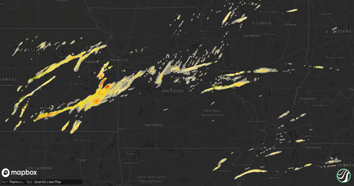
Hail Map in Missouri on April 2, 2014
Get this storm
April 2 map
$229
one time, instant access
Download today. No call, no setup
Keep the $229
Bought the map and want the full workflow? Apply the entire $229 to a subscription within 7 days. None of it is wasted.
Every map, not just this one
This buys you this map. Subscription and you get every map we run, in the markets you choose from a few cities to whole states to nationwide. Plus real-time alerts the moment a storm fires.
Contact data
Name, contact info, occupancy, even credit band for addresses in the footprint. You go from where it hit to who to call.
Become the source they trust
Unlimited branding weather history reports on demand. You already have the documented answer ready for the property owner, and you are the one who showed up with it.
Property data and RoofTrace estimates
Pull up any address you have got, its value and the exact code rules for that jurisdiction, straight from One Click Code. Then RoofTrace estimates the squares, pitch, and roof value, priced the way you price.
Storm reports in Missouri
Missouri
| Date | Description |
|---|---|
| 04/02/20141:20 PM CDT | Around 1 minute of torrential 1 inch hail at the goodfellow federal complex in north st. Louis. |
| 04/02/20141:17 PM CDT | Lindbergh at olive |
| 04/02/20141:13 PM CDT | Golf ball sized hail at broadway and i-70 |
| 04/02/20141:03 PM CDT | 0.75 to 1 inch hail on the west side of olivette |
| 04/02/20141:00 PM CDT | 1 to 1.25 inch hail at mercy hospital |
| 04/02/20141:00 PM CDT | St. Mercy hospital 270 at i-64 |
| 04/02/201411:00 AM CDT | Hail ranged from 0.25 to 1 inch |
| 04/02/201410:40 AM CDT | A local report indicates 1.00 inch wind near HILLSBORO |
| 04/02/201410:34 AM CDT | Hail size varied from pea to quarter. |
| 04/02/201410:25 AM CDT | A local report indicates 1.00 inch wind near LONEDELL |
| 04/02/201410:15 AM CDT | A local report indicates 1.00 inch wind near ST. CLAIR |
| 04/02/201410:14 AM CDT | Half-dollar sized hail at i-44 and u.s. Hwy 47. Also... Spotter noticed slight rotation of a wall cloud at this location. |
| 04/02/20149:55 AM CDT | Damage to cars from earlier hail. Home siding damaged at calwood... Mo. Hail size was estimated and not directly observed. |
| 04/02/20148:51 AM CDT | A local report indicates 1.00 inch wind near MONTGOMERY CITY |
| 04/02/20148:28 AM CDT | Hail up to the size of quarters south of fulton. |
| 04/02/20148:22 AM CDT | Half dollar size hail. |
| 04/02/20147:55 AM CDT | A local report indicates 1.25 inch wind near FULTON |
| 04/02/20147:51 AM CDT | A local report indicates 1.00 inch wind near FULTON |
| 04/02/20147:50 AM CDT | E-spotter report of 1-inch hail. Numerous reports of quarter-sized hail in fulton. |
| 04/02/20147:38 AM CDT | Picture of hail up to the size of quarters sent in from social media on the dallas/leclede county line |
| 04/02/20147:28 AM CDT | Quarter size hail in downtown columbia. |
| 04/02/20147:27 AM CDT | Update from spotter...hail has covered ground with largest stones the size of half dollars. |
| 04/02/20147:19 AM CDT | Spotter reports nickel to quarter size hail. |
| 04/02/20145:47 AM CDT | Roofing material off home...trees twisted...debris on roads...and fences blown down. Near mcknight and olive. |
| 04/02/20145:23 AM CDT | Possible tornadic damage...city administrator reports approx 100 homes with minor daamge |
| 04/02/20145:23 AM CDT | Trees down on delmar at north-south road. Twitter report. |
| 04/02/20145:16 AM CDT | Trees blown down. Widespread power outages. |
| 04/02/20141:46 AM CDT | A local report indicates 1.25 inch wind near BUTLER |
| 04/02/20141:19 AM CDT | Quarter size hail and heavy rain. |
| 04/02/20141:10 AM CDT | Heavy rain and quarter size hail. Frequent lightning. |
All States Impacted by Hail Map on April 2, 2014
Cities Impacted by Hail Map on April 2, 2014
- Smithville, TN
- Sparta, TN
- Turon, KS
- Cunningham, KS
- Marquette, KS
- Windom, KS
- Little River, KS
- Vienna, MO
- Brookport, IL
- Golconda, IL
- Jamestown, MO
- Wooldridge, MO
- Columbia, MO
- West Point, IL
- Warsaw, IL
- Sutter, IL
- Basco, IL
- East Carondelet, IL
- East Saint Louis, IL
- Saint Louis, MO
- Otterville, MO
- Fulton, MO
- Williamsburg, MO
- Ashland, MO
- New Florence, MO
- Hartsburg, MO
- New Bloomfield, MO
- Portland, MO
- Steedman, MO
- Montgomery City, MO
- Peoria, IL
- Boaz, KY
- Hume, MO
- Rich Hill, MO
- Fort Scott, KS
- Uniontown, KS
- Redfield, KS
- Clearwater, KS
- Mayetta, KS
- Pretty Prairie, KS
- Kingman, KS
- Peck, KS
- Mulvane, KS
- Corning, KS
- Goff, KS
- Seneca, KS
- Macon, MO
- Sunset, TX
- Bowie, TX
- Newton, IL
- Spivey, KS
- Hillsboro, KS
- Lehigh, KS
- Tampa, KS
- Canton, KS
- Durham, KS
- Bonnots Mill, MO
- Jefferson City, MO
- Chamois, MO
- Ladoga, IN
- Atlanta, MO
- Anabel, MO
- Cadiz, KY
- Viola, KS
- Butler, MO
- Cedar Vale, KS
- Dexter, KS
- High Hill, MO
- Garden City, MO
- Creighton, MO
- Alma, KS
- Eskridge, KS
- Nelson, MO
- Marshall, MO
- Arlington, KS
- Abbyville, KS
- Inman, KS
- Conway Springs, KS
- Wellington, KS
- Belle Plaine, KS
- Parker, KS
- Centerville, KS
- Fontana, KS
- Greeley, KS
- Garnett, KS
- Toronto, KS
- Virgil, KS
- Eureka, KS
- Abilene, KS
- Walnut Ridge, AR
- Alicia, AR
- Colchester, IL
- New Boston, IL
- Joy, IL
- New Athens, IL
- Waterloo, IL
- Freeburg, IL
- Columbia, IL
- Barnhart, MO
- Millstadt, IL
- Valmeyer, IL
- Cedar Hill, MO
- Hillsboro, MO
- Mascoutah, IL
- Smithton, IL
- Dittmer, MO
- Belleville, IL
- Pevely, MO
- Imperial, MO
- Milton, KS
- Norwich, KS
- Saint Clair, MO
- Union, MO
- Douglass, KS
- Westphalia, MO
- Loose Creek, MO
- Clay, KY
- Dixon, KY
- Providence, KY
- Union City, TN
- Antioch, TN
- Nashville, TN
- Herod, IL
- Elizabethtown, IL
- Rosiclare, IL
- Waldron, KS
- Attica, KS
- Hazelton, KS
- Kiowa, KS
- Ottawa, KS
- Avon, IL
- Wellsville, KS
- Edgerton, KS
- Eudora, KS
- Baldwin City, KS
- La Monte, MO
- Green Ridge, MO
- Sedalia, MO
- Knob Noster, MO
- Annada, MO
- Elsberry, MO
- Alma, IL
- Lincoln, MO
- Cole Camp, MO
- Fall River, KS
- Fredonia, KS
- Chesterfield, MO
- Havana, IL
- Hughesville, MO
- Clyde, KS
- Russellville, MO
- Osawatomie, KS
- Princeton, KS
- Rantoul, KS
- Richmond, KS
- Easton, IL
- Adair, IL
- Industry, IL
- Littleton, IL
- Latham, KS
- Beaumont, KS
- Piedmont, KS
- Leon, KS
- Maple Hill, KS
- Hope, KS
- Enterprise, KS
- Chapman, KS
- Blue Rapids, KS
- Randolph, KS
- Shelbyville, MO
- Bridgeport, TX
- Hurricane Mills, TN
- Jonesburg, MO
- Wapello, IA
- Pacific, MO
- Eureka, MO
- Wildwood, MO
- Saint Albans, MO
- Labadie, MO
- Augusta, MO
- Fenton, MO
- Defiance, MO
- High Ridge, MO
- Valley Park, MO
- Ballwin, MO
- Clifton, KS
- Clay Center, KS
- Palmer, KS
- Miltonvale, KS
- Morganville, KS
- Tipton, KS
- Beloit, KS
- Sherrard, IL
- Aledo, IL
- Reynolds, IL
- Milan, IL
- Bono, AR
- Beech Grove, AR
- Villa Ridge, MO
- Robertsville, MO
- Catawissa, MO
- Florence, MO
- Syracuse, MO
- Bunceton, MO
- Mora, MO
- New Franklin, MO
- Boonville, MO
- Pilot Grove, MO
- Smithton, MO
- Stover, MO
- Gates, TN
- Ripley, TN
- Loretto, KY
- Springfield, KY
- Granite City, IL
- Madison, IL
- Venice, IL
- Gray Summit, MO
- Hermann, MO
- Mound City, KS
- Leeton, MO
- Neal, KS
- Archie, MO
- Le Roy, KS
- Adrian, MO
- Chilhowee, MO
- Blue Mound, KS
- Iola, KS
- La Harpe, KS
- Severy, KS
- Atlanta, KS
- Urich, MO
- Mapleton, KS
- Rock, KS
- Neosho Falls, KS
- Warrensburg, MO
- Welda, KS
- Harrisonville, MO
- Kincaid, KS
- Yates Center, KS
- Moran, KS
- Amsterdam, MO
- Argonia, KS
- Buffalo, KS
- Foster, MO
- Centerview, MO
- Holden, MO
- Blairstown, MO
- Piqua, KS
- Prescott, KS
- Fulton, KS
- Udall, KS
- Pleasanton, KS
- Bronson, KS
- Derby, KS
- Paola, KS
- Haysville, KS
- Lane, KS
- Augusta, KS
- Humboldt, KS
- Benedict, KS
- Westphalia, KS
- Amoret, MO
- Colony, KS
- Rose Hill, KS
- La Cygne, KS
- Drexel, MO
- Portageville, MO
- Cash, AR
- Valley Falls, KS
- Denison, KS
- Sedan, KS
- De Soto, KS
- Mexico, MO
- Dickson, TN
- McEwen, TN
- Watertown, TN
- Peoria Heights, IL
- Morning Sun, IA
- Orion, IL
- Coal Valley, IL
- Atchison, KS
- Cummings, KS
- Water Valley, KY
- Salina, KS
- Gypsum, KS
- Dresden, TN
- Martin, TN
- Danville, KY
- Junction City, KY
- Parksville, KY
- Stanford, KY
- Lancaster, KY
- Lake City, KS
- Medicine Lodge, KS
- Beardstown, IL
- Arenzville, IL
- Houstonia, MO
- Pomona, KS
- Highland, IL
- Saint Jacob, IL
- Marine, IL
- Steelville, MO
- Davisville, MO
- Viburnum, MO
- Junction City, KS
- Woodbine, KS
- Wayland, MO
- Bardstown, KY
- New Haven, KY
- Lebanon, KY
- Saint Catharine, KY
- Mackville, KY
- Canton, IL
- Linwood, KS
- Pleasant Hill, MO
- Raymore, MO
- Peculiar, MO
- Wellsville, MO
- Holts Summit, MO
- California, MO
- Franklin, MO
- Hawk Point, MO
- Martinsburg, MO
- Clarksburg, MO
- Troy, MO
- Mokane, MO
- Thompson, MO
- Prairie Home, MO
- Rocheport, MO
- Truxton, MO
- Tipton, MO
- Hallsville, MO
- Fayette, MO
- Bellflower, MO
- Centertown, MO
- Auxvasse, MO
- Tebbetts, MO
- Laddonia, MO
- Rush Hill, MO
- Minneapolis, KS
- Galva, KS
- Hutchinson, KS
- Mcpherson, KS
- Buhler, KS
- Moundridge, KS
- Metamora, IL
- Friendship, TN
- Halls, TN
- Alamo, TN
- Hoyt, KS
- Assaria, KS
- Lindsborg, KS
- Sugar Tree, TN
- Holladay, TN
- Waverly, TN
- Oak Grove, KY
- Hopkinsville, KY
- Harriman, TN
- New London, MO
- Center, MO
- Clarksville, MO
- Saint Marys, KS
- Rossville, KS
- Lyons, KS
- Roseville, IL
- Good Hope, IL
- Benson, IL
- Roanoke, IL
- Glen Carbon, IL
- Collinsville, IL
- Maryville, IL
- Forest City, IL
- Kilbourne, IL
- Bath, IL
- Benton, KY
- Mayfield, KY
- Kirksey, KY
- Rockville, MO
- Nebo, IL
- Winchester, KS
- Baring, MO
- Memphis, MO
- Brashear, MO
- Greentop, MO
- Herndon, KY
- Blackwater, MO
- Aurora, KS
- Concordia, KS
- El Dorado, KS
- Delphos, KS
- Cuba, MO
- Lowry City, MO
- Rhineland, MO
- Lost Springs, KS
- Ramona, KS
- Isabel, KS
- Perry, KS
- Lecompton, KS
- Deer Creek, IL
- Morton, IL
- Luxora, AR
- Wilson, AR
- Osceola, AR
- Keiser, AR
- Longton, KS
- Elk City, KS
- Carlyle, IL
- Shobonier, IL
- Breese, IL
- Vernon, IL
- Vandalia, IL
- Farina, IL
- Xenia, IL
- Smithboro, IL
- Patoka, IL
- Kinmundy, IL
- Greenville, IL
- Mulberry Grove, IL
- Saint Peter, IL
- Pocahontas, IL
- Louisville, IL
- Keyesport, IL
- Paris, MO
- Lohman, MO
- Nortonville, KS
- Manhattan, KS
- Ozawkie, KS
- Holton, KS
- Rushville, MO
- Lancaster, KS
- Topeka, KS
- Wamego, KS
- Saint George, KS
- Paxico, KS
- Effingham, KS
- Delia, KS
- Emmett, KS
- Muscotah, KS
- Solomon, KS
- Silver Lake, KS
- Alta Vista, KS
- Belvue, KS
- Paducah, KY
- Symsonia, KY
- Plymouth, IL
- Vermont, IL
- Table Grove, IL
- Freeburg, MO
- Lonedell, MO
- Westport, TN
- Ellisville, IL
- Cuba, IL
- Wheeler, IL
- Dieterich, IL
- Hickory, KY
- Linn, MO
- Eldon, MO
- Lake Ozark, MO
- Olathe, KS
- Gardner, KS
- Olney, IL
- Noble, IL
- Bourbon, MO
- Columbus Junction, IA
- Letts, IA
- Hornbeak, TN
- Troy, TN
- Dyess, AR
- Lewistown, IL
- Ipava, IL
- Belleville, KS
- Scandia, KS
- Zenda, KS
- Marion, KS
- Lincolnville, KS
- Partridge, KS
- Herington, KS
- Belle, MO
- Lebanon, IL
- Grubville, MO
- O'Fallon, IL
- Scott Air Force Base, IL
- Luebbering, MO
- Sullivan, MO
- Novelty, MO
- Hurdland, MO
- Edina, MO
- Auburntown, TN
- Loda, IL
- Melvin, IL
- Paxton, IL
- Cissna Park, IL
- Marion, KY
- Bowling Green, MO
- Lebanon, IN
- Dexter, KY
- Alden, KS
- Richmond, MO
- Farmington, KY
- Saybrook, IL
- Rushville, IL
- Ashland, IL
- Lawrence, KS
- Glasgow, MO
- Mankato, KS
- Glen Elder, KS
- Leonardville, KS
- Green, KS
- Forestburg, TX
- Topeka, IL
- Astoria, IL
- Browning, IL
- Gravel Switch, KY
- Perryville, KY
- New Baden, IL
- Fairview, TN
- Dupo, IL
- Fairview Heights, IL
- Caseyville, IL
- Troy, IL
- Camden, IL
- Barnes, KS
- Marietta, IL
- Owensville, MO
- Mitchell, IN
- Bedford, IN
- Oliver Springs, TN
- Elnora, IN
- Benton City, MO
- Galesburg, IL
- Wataga, IL
- East Galesburg, IL
- Du Quoin, IL
- Clark, MO
- Higbee, MO
- Vermillion, KS
- Carrollton, MO
- Bogard, MO
- Chanute, KS
- Louisburg, KS
- Elsmore, KS
- Kingsville, MO
- Hamilton, KS
- Eolia, MO
- Pleasant Hill, IL
- Bartelso, IL
- Salem, KY
- Smyrna, TN
- La Vergne, TN
- Nolensville, TN
- Brentwood, TN
- Towanda, KS
- Benton, KS
- Andover, KS
- Farmington, IL
- Elmwood, IL
- Carlisle, IN
- Liberty, MO
- Palmersville, TN
- Ellington, MO
- Oakford, IL
- Chandlerville, IL
- Franklin, TN
- Fulton, KY
- Montrose, MO
- Mount Juliet, TN
- Middletown, MO
- Hermitage, TN
- Jamestown, KS
- Gravois Mills, MO
- Sunrise Beach, MO
- Old Hickory, TN
- Madison, TN
- Vandalia, MO
- Alvord, TX
- Pawhuska, OK
- Rosalia, KS
- Sterling, KS
- Delaplaine, AR
- Swifton, AR
- Paragould, AR
- Pittsfield, IL
- Perry, MO
- Macomb, IL
- Berger, MO
- Marthasville, MO
- Calvert City, KY
- Bevier, MO
- Humboldt, TN
- Lavinia, TN
- Chambersburg, IL
- Versailles, IL
- Meredosia, IL
- Windsor, MO
- Hickman, KY
- Bosworth, MO
- Tina, MO
- Harrisburg, MO
- Blytheville, AR
- Kingdom City, MO
- Morrison, MO
- Onaga, KS
- Frankfort, KS
- Centralia, KS
- Westmoreland, KS
- Kirksville, MO
- La Plata, MO
- Alexandria, MO
- Louisiana, MO
- Rockport, IL
- South Fulton, TN
- Kahoka, MO
- Dyersburg, TN
- Timewell, IL
- Argyle, MO
- Peru, KS
- Lebanon, TN
- Sturgeon, MO
- Centralia, MO
- Jewell, KS
- Elk Falls, KS
- Robinson, IL
- Eureka, IL
- Washington, IL
- Greenleaf, KS
- Walling, TN
- Bushnell, IL
- Armstrong, MO
- Eugene, MO
- Carthage, IL
- Dallas City, IL
- Rayville, MO
- Excelsior Springs, MO
- Orrick, MO
- Perrin, TX
- Berwick, IL
- Maple City, KS
- Grenola, KS
- Harper, KS
- East Prairie, MO
- Norborne, MO
- Obion, TN
- Ridgely, TN
- Blandinsville, IL
- Bland, MO
- Downing, MO
- Rives, TN
- Beaufort, MO
- London Mills, IL
- Saint Augustine, IL
- Winchester, IL
- Odon, IN
- Sandborn, IN
- Yates City, IL
- Mount Union, IA
- Winfield, IA
- Trivoli, IL
- Mount Sterling, IL
- Curryville, MO
- Hunter, KS
- Lucas, KS
- Osborne, KS
- Smithfield, IL
- Newberry, IN
- Oaktown, IN
- Edwardsport, IN
- Westphalia, IN
- Chico, TX
- Jamestown, IN
- Overbrook, KS
- Quenemo, KS
- Wyaconda, MO
- Williamstown, MO
- La Belle, MO
- Wichita, KS
- Long Lane, MO
- Lebanon, MO
- Phillipsburg, MO
- Saint Patrick, MO
- Muscatine, IA
- Admire, KS
- Reading, KS
- Gibson City, IL
- Rector, AR
- Piggott, AR
- Groveland, IL
- Tremont, IL
- Cottage Grove, TN
- Oakdale, TN
- Rockwood, TN
- Lizton, IN
- Williams, IN
- Dundas, IL
- Washington, MO
- Leonard, MO
- Wildersville, TN
- Griggsville, IL
- Eddyville, IL
- Crofton, KY
- Bonner Springs, KS
- Pearl, IL
- Silex, MO
- Henley, MO
- Germantown, IL
- Clay City, IL
- Sailor Springs, IL
- East Peoria, IL
- Howard, KS
- House Springs, MO
- Edwardsville, IL
- Nickerson, KS
- Plevna, KS
- Chase, KS
- Lyons, IN
- Harrodsburg, KY


