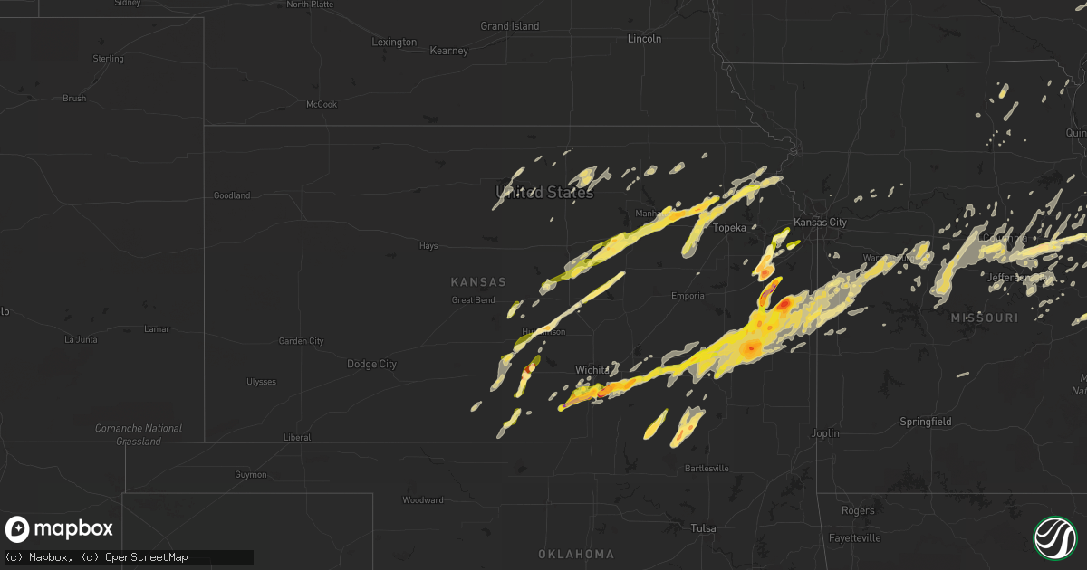
Hail Map in Kansas on April 2, 2014
Get this storm
April 2 map
$229
one time, instant access
Download today. No call, no setup
Keep the $229
Bought the map and want the full workflow? Apply the entire $229 to a subscription within 7 days. None of it is wasted.
Every map, not just this one
This buys you this map. Subscription and you get every map we run, in the markets you choose from a few cities to whole states to nationwide. Plus real-time alerts the moment a storm fires.
Contact data
Name, contact info, occupancy, even credit band for addresses in the footprint. You go from where it hit to who to call.
Become the source they trust
Unlimited branding weather history reports on demand. You already have the documented answer ready for the property owner, and you are the one who showed up with it.
Property data and RoofTrace estimates
Pull up any address you have got, its value and the exact code rules for that jurisdiction, straight from One Click Code. Then RoofTrace estimates the squares, pitch, and roof value, priced the way you price.
Storm reports in Kansas
Kansas
| Date | Description |
|---|---|
| 04/02/20146:42 PM CDT | A local report indicates 1.00 inch wind near 5 W HUMBOLDT |
| 04/02/20142:45 AM CDT | Pockets of wind damage including downed power lines... Large trees down...and heavily damaged barns and outbuildings. |
| 04/02/20142:30 AM CDT | Loose tin blown around 100 feet. Time estimated based on radar data. |
| 04/02/201412:30 AM CDT | A local report indicates 1.25 inch wind near 3 E HERINGTON |
| 04/02/201412:25 AM CDT | A local report indicates 1.00 inch wind near 2 S KINCAID |
| 04/02/201412:20 AM CDT | Barn blown over 5 miles south of yates center. Time estimated from radar |
| 04/01/201411:46 PM CDT | A local report indicates 1.00 inch wind near DURHAM |
| 04/01/201411:35 PM CDT | Delayed report with time estimated from radar |
| 04/01/201411:21 PM CDT | A local report indicates 1.00 inch wind near SILVER LAKE |
| 04/01/201411:20 PM CDT | A local report indicates 1.00 inch wind near VALLEY FALLS |
| 04/01/201411:15 PM CDT | Reported via twitter |
| 04/01/201411:12 PM CDT | A local report indicates 1.00 inch wind near 1 S LE ROY |
| 04/01/201411:03 PM CDT | Delayed report |
| 04/01/201410:46 PM CDT | Hail covering the ground |
| 04/01/201410:45 PM CDT | A local report indicates 1.75 inch wind near 5 NW ROSSVILLE |
| 04/01/201410:40 PM CDT | Relayed via facebook. Delayed report. |
| 04/01/201410:30 PM CDT | A local report indicates 1.00 inch wind near LINWOOD |
| 04/01/201410:29 PM CDT | Quarter size hail covering the ground |
| 04/01/201410:21 PM CDT | Delayed report |
| 04/01/201410:21 PM CDT | Delayed report |
| 04/01/201410:21 PM CDT | A local report indicates 1.50 inch wind near HUTCHINSON |
| 04/01/201410:12 PM CDT | Reported via twitter |
| 04/01/20149:51 PM CDT | From cocorahs |
| 04/01/20149:51 PM CDT | Reported via twitter |
| 04/01/20149:50 PM CDT | Social media photo of 1.5 inch hail. Time estimated based on radar. |
| 04/01/20149:48 PM CDT | Us54 in the town of neal |
| 04/01/20149:43 PM CDT | A local report indicates 1.75 inch wind near 4 E DOUGLASS |
| 04/01/20149:37 PM CDT | Time estimated from radar |
| 04/01/20149:36 PM CDT | A local report indicates 1.00 inch wind near ABILENE |
| 04/01/20149:35 PM CDT | Relayed by emergency management. |
| 04/01/20149:34 PM CDT | A local report indicates 1.00 inch wind near DOUGLASS |
| 04/01/20149:32 PM CDT | 1800 rd and linn/anderson county line |
| 04/01/20149:31 PM CDT | A local report indicates 1.75 inch wind near PARKER |
| 04/01/20149:30 PM CDT | A local report indicates 1.00 inch wind near 5 NE CLIMAX |
| 04/01/20149:30 PM CDT | Delayed report |
| 04/01/20149:27 PM CDT | A local report indicates 1.00 inch wind near 2 W DOUGLASS |
| 04/01/20149:26 PM CDT | A local report indicates 1.75 inch wind near ROSE HILL |
| 04/01/20149:24 PM CDT | A local report indicates 1.75 inch wind near 3 S ROSE HILL |
| 04/01/20149:24 PM CDT | A local report indicates 1.00 inch wind near 4 WSW BALDWIN CITY |
| 04/01/20149:24 PM CDT | A local report indicates 1.50 inch wind near 3 SSE BALDWIN CITY |
| 04/01/20149:23 PM CDT | Car windshields busted out at the kansas star casino |
| 04/01/20149:22 PM CDT | A local report indicates 1.00 inch wind near 4 WSW BALDWIN CITY |
| 04/01/20149:21 PM CDT | A local report indicates 1.75 inch wind near 2 S ROSE HILL |
| 04/01/20149:20 PM CDT | Quarter size hail at 95th street south and k15 |
| 04/01/20149:10 PM CDT | Golfball size hail reported in peck. Time estimated from radar |
| 04/01/20149:08 PM CDT | A local report indicates 1.00 inch wind near 3 NE ASSARIA |
| 04/01/20149:08 PM CDT | A local report indicates 1.00 inch wind near TURON |
| 04/01/20149:06 PM CDT | A local report indicates 1.00 inch wind near 5 S ENTERPRISE |
| 04/01/20149:02 PM CDT | Golfball hail reported at broadway and 119th county line road. |
| 04/01/20149:00 PM CDT | A local report indicates 2.00 inch wind near OTTAWA |
| 04/01/20148:56 PM CDT | A local report indicates 1.00 inch wind near 2 S OTTAWA |
| 04/01/20148:56 PM CDT | A local report indicates 1.75 inch wind near S OTTAWA |
| 04/01/20148:50 PM CDT | 103rd and ridge road |
| 04/01/20148:50 PM CDT | A local report indicates 1.00 inch wind near CLEARWATER |
| 04/01/20148:45 PM CDT | A local report indicates 1.00 inch wind near 9 S ABILENE |
| 04/01/20148:45 PM CDT | A local report indicates 1.00 inch wind near 12 S ABILENE |
| 04/01/20148:42 PM CDT | A local report indicates 1.00 inch wind near 5 SE ASSARIA |
| 04/01/20148:40 PM CDT | A local report indicates 1.25 inch wind near 4 E CONWAY SPRINGS |
| 04/01/20148:36 PM CDT | A local report indicates 1.25 inch wind near CONWAY SPRINGS |
| 04/01/20148:30 PM CDT | A local report indicates 1.00 inch wind near LONE ELM |
| 04/01/20148:30 PM CDT | A local report indicates 1.75 inch wind near 2 WSW KINCAID |
| 04/01/20148:29 PM CDT | A local report indicates 1.00 inch wind near LINDSBORG |
| 04/01/20148:23 PM CDT | Storm chaser reported a brief rope tornado 5 miles southwest of elk city while traveling on saddle road. |
| 04/01/20148:13 PM CDT | A local report indicates 1.00 inch wind near RANTOUL |
| 04/01/20148:12 PM CDT | A local report indicates 1.00 inch wind near 2 S KINCAID |
| 04/01/20148:12 PM CDT | A local report indicates 1.00 inch wind near WNW RANTOUL |
| 04/01/20148:10 PM CDT | A local report indicates 1.50 inch wind near 2 WSW RANTOUL |
| 04/01/20148:00 PM CDT | A local report indicates 1.00 inch wind near 2 E PRINCETON |
| 04/01/20148:00 PM CDT | A local report indicates 1.75 inch wind near SEDAN |
| 04/01/20147:55 PM CDT | A local report indicates 1.00 inch wind near 4 S GRENOLA |
| 04/01/20147:54 PM CDT | Dime to quarter size hail |
| 04/01/20147:52 PM CDT | A local report indicates 1.00 inch wind near RICHMOND |
| 04/01/20147:47 PM CDT | A local report indicates 1.00 inch wind near 3 S SEDAN |
| 04/01/20147:42 PM CDT | A local report indicates 1.50 inch wind near SEDAN |
| 04/01/20147:31 PM CDT | A local report indicates 2.00 inch wind near 3 S IOLA |
| 04/01/20147:31 PM CDT | A local report indicates 1.75 inch wind near ELGIN |
| 04/01/20147:30 PM CDT | A local report indicates 1.75 inch wind near 5 SE DEXTER |
| 04/01/20147:28 PM CDT | A local report indicates 1.25 inch wind near IOLA |
| 04/01/20147:26 PM CDT | A local report indicates 1.75 inch wind near IOLA |
| 04/01/20147:25 PM CDT | Damage to several vehicles. |
| 04/01/20147:24 PM CDT | A local report indicates 1.25 inch wind near 6 S GARNETT |
| 04/01/20147:24 PM CDT | A local report indicates 1.00 inch wind near IOLA |
| 04/01/20147:23 PM CDT | A local report indicates 1.00 inch wind near GAS |
| 04/01/20147:20 PM CDT | A local report indicates 2.50 inch wind near IOLA |
| 04/01/20147:20 PM CDT | Reported from twitter |
| 04/01/20147:19 PM CDT | A local report indicates 1.75 inch wind near 7 SW KINGMAN |
| 04/01/20147:16 PM CDT | A local report indicates 1.50 inch wind near IOLA |
| 04/01/20147:13 PM CDT | A local report indicates 1.00 inch wind near COLONY |
| 04/01/20147:07 PM CDT | A local report indicates 1.25 inch wind near ZENDA |
All States Impacted by Hail Map on April 2, 2014
Cities Impacted by Hail Map on April 2, 2014
- Smithville, TN
- Sparta, TN
- Turon, KS
- Cunningham, KS
- Marquette, KS
- Windom, KS
- Little River, KS
- Vienna, MO
- Brookport, IL
- Golconda, IL
- Jamestown, MO
- Wooldridge, MO
- Columbia, MO
- West Point, IL
- Warsaw, IL
- Sutter, IL
- Basco, IL
- East Carondelet, IL
- East Saint Louis, IL
- Saint Louis, MO
- Otterville, MO
- Fulton, MO
- Williamsburg, MO
- Ashland, MO
- New Florence, MO
- Hartsburg, MO
- New Bloomfield, MO
- Portland, MO
- Steedman, MO
- Montgomery City, MO
- Peoria, IL
- Boaz, KY
- Hume, MO
- Rich Hill, MO
- Fort Scott, KS
- Uniontown, KS
- Redfield, KS
- Clearwater, KS
- Mayetta, KS
- Pretty Prairie, KS
- Kingman, KS
- Peck, KS
- Mulvane, KS
- Corning, KS
- Goff, KS
- Seneca, KS
- Macon, MO
- Sunset, TX
- Bowie, TX
- Newton, IL
- Spivey, KS
- Hillsboro, KS
- Lehigh, KS
- Tampa, KS
- Canton, KS
- Durham, KS
- Bonnots Mill, MO
- Jefferson City, MO
- Chamois, MO
- Ladoga, IN
- Atlanta, MO
- Anabel, MO
- Cadiz, KY
- Viola, KS
- Butler, MO
- Cedar Vale, KS
- Dexter, KS
- High Hill, MO
- Garden City, MO
- Creighton, MO
- Alma, KS
- Eskridge, KS
- Nelson, MO
- Marshall, MO
- Arlington, KS
- Abbyville, KS
- Inman, KS
- Conway Springs, KS
- Wellington, KS
- Belle Plaine, KS
- Parker, KS
- Centerville, KS
- Fontana, KS
- Greeley, KS
- Garnett, KS
- Toronto, KS
- Virgil, KS
- Eureka, KS
- Abilene, KS
- Walnut Ridge, AR
- Alicia, AR
- Colchester, IL
- New Boston, IL
- Joy, IL
- New Athens, IL
- Waterloo, IL
- Freeburg, IL
- Columbia, IL
- Barnhart, MO
- Millstadt, IL
- Valmeyer, IL
- Cedar Hill, MO
- Hillsboro, MO
- Mascoutah, IL
- Smithton, IL
- Dittmer, MO
- Belleville, IL
- Pevely, MO
- Imperial, MO
- Milton, KS
- Norwich, KS
- Saint Clair, MO
- Union, MO
- Douglass, KS
- Westphalia, MO
- Loose Creek, MO
- Clay, KY
- Dixon, KY
- Providence, KY
- Union City, TN
- Antioch, TN
- Nashville, TN
- Herod, IL
- Elizabethtown, IL
- Rosiclare, IL
- Waldron, KS
- Attica, KS
- Hazelton, KS
- Kiowa, KS
- Ottawa, KS
- Avon, IL
- Wellsville, KS
- Edgerton, KS
- Eudora, KS
- Baldwin City, KS
- La Monte, MO
- Green Ridge, MO
- Sedalia, MO
- Knob Noster, MO
- Annada, MO
- Elsberry, MO
- Alma, IL
- Lincoln, MO
- Cole Camp, MO
- Fall River, KS
- Fredonia, KS
- Chesterfield, MO
- Havana, IL
- Hughesville, MO
- Clyde, KS
- Russellville, MO
- Osawatomie, KS
- Princeton, KS
- Rantoul, KS
- Richmond, KS
- Easton, IL
- Adair, IL
- Industry, IL
- Littleton, IL
- Latham, KS
- Beaumont, KS
- Piedmont, KS
- Leon, KS
- Maple Hill, KS
- Hope, KS
- Enterprise, KS
- Chapman, KS
- Blue Rapids, KS
- Randolph, KS
- Shelbyville, MO
- Bridgeport, TX
- Hurricane Mills, TN
- Jonesburg, MO
- Wapello, IA
- Pacific, MO
- Eureka, MO
- Wildwood, MO
- Saint Albans, MO
- Labadie, MO
- Augusta, MO
- Fenton, MO
- Defiance, MO
- High Ridge, MO
- Valley Park, MO
- Ballwin, MO
- Clifton, KS
- Clay Center, KS
- Palmer, KS
- Miltonvale, KS
- Morganville, KS
- Tipton, KS
- Beloit, KS
- Sherrard, IL
- Aledo, IL
- Reynolds, IL
- Milan, IL
- Bono, AR
- Beech Grove, AR
- Villa Ridge, MO
- Robertsville, MO
- Catawissa, MO
- Florence, MO
- Syracuse, MO
- Bunceton, MO
- Mora, MO
- New Franklin, MO
- Boonville, MO
- Pilot Grove, MO
- Smithton, MO
- Stover, MO
- Gates, TN
- Ripley, TN
- Loretto, KY
- Springfield, KY
- Granite City, IL
- Madison, IL
- Venice, IL
- Gray Summit, MO
- Hermann, MO
- Mound City, KS
- Leeton, MO
- Neal, KS
- Archie, MO
- Le Roy, KS
- Adrian, MO
- Chilhowee, MO
- Blue Mound, KS
- Iola, KS
- La Harpe, KS
- Severy, KS
- Atlanta, KS
- Urich, MO
- Mapleton, KS
- Rock, KS
- Neosho Falls, KS
- Warrensburg, MO
- Welda, KS
- Harrisonville, MO
- Kincaid, KS
- Yates Center, KS
- Moran, KS
- Amsterdam, MO
- Argonia, KS
- Buffalo, KS
- Foster, MO
- Centerview, MO
- Holden, MO
- Blairstown, MO
- Piqua, KS
- Prescott, KS
- Fulton, KS
- Udall, KS
- Pleasanton, KS
- Bronson, KS
- Derby, KS
- Paola, KS
- Haysville, KS
- Lane, KS
- Augusta, KS
- Humboldt, KS
- Benedict, KS
- Westphalia, KS
- Amoret, MO
- Colony, KS
- Rose Hill, KS
- La Cygne, KS
- Drexel, MO
- Portageville, MO
- Cash, AR
- Valley Falls, KS
- Denison, KS
- Sedan, KS
- De Soto, KS
- Mexico, MO
- Dickson, TN
- McEwen, TN
- Watertown, TN
- Peoria Heights, IL
- Morning Sun, IA
- Orion, IL
- Coal Valley, IL
- Atchison, KS
- Cummings, KS
- Water Valley, KY
- Salina, KS
- Gypsum, KS
- Dresden, TN
- Martin, TN
- Danville, KY
- Junction City, KY
- Parksville, KY
- Stanford, KY
- Lancaster, KY
- Lake City, KS
- Medicine Lodge, KS
- Beardstown, IL
- Arenzville, IL
- Houstonia, MO
- Pomona, KS
- Highland, IL
- Saint Jacob, IL
- Marine, IL
- Steelville, MO
- Davisville, MO
- Viburnum, MO
- Junction City, KS
- Woodbine, KS
- Wayland, MO
- Bardstown, KY
- New Haven, KY
- Lebanon, KY
- Saint Catharine, KY
- Mackville, KY
- Canton, IL
- Linwood, KS
- Pleasant Hill, MO
- Raymore, MO
- Peculiar, MO
- Wellsville, MO
- Holts Summit, MO
- California, MO
- Franklin, MO
- Hawk Point, MO
- Martinsburg, MO
- Clarksburg, MO
- Troy, MO
- Mokane, MO
- Thompson, MO
- Prairie Home, MO
- Rocheport, MO
- Truxton, MO
- Tipton, MO
- Hallsville, MO
- Fayette, MO
- Bellflower, MO
- Centertown, MO
- Auxvasse, MO
- Tebbetts, MO
- Laddonia, MO
- Rush Hill, MO
- Minneapolis, KS
- Galva, KS
- Hutchinson, KS
- Mcpherson, KS
- Buhler, KS
- Moundridge, KS
- Metamora, IL
- Friendship, TN
- Halls, TN
- Alamo, TN
- Hoyt, KS
- Assaria, KS
- Lindsborg, KS
- Sugar Tree, TN
- Holladay, TN
- Waverly, TN
- Oak Grove, KY
- Hopkinsville, KY
- Harriman, TN
- New London, MO
- Center, MO
- Clarksville, MO
- Saint Marys, KS
- Rossville, KS
- Lyons, KS
- Roseville, IL
- Good Hope, IL
- Benson, IL
- Roanoke, IL
- Glen Carbon, IL
- Collinsville, IL
- Maryville, IL
- Forest City, IL
- Kilbourne, IL
- Bath, IL
- Benton, KY
- Mayfield, KY
- Kirksey, KY
- Rockville, MO
- Nebo, IL
- Winchester, KS
- Baring, MO
- Memphis, MO
- Brashear, MO
- Greentop, MO
- Herndon, KY
- Blackwater, MO
- Aurora, KS
- Concordia, KS
- El Dorado, KS
- Delphos, KS
- Cuba, MO
- Lowry City, MO
- Rhineland, MO
- Lost Springs, KS
- Ramona, KS
- Isabel, KS
- Perry, KS
- Lecompton, KS
- Deer Creek, IL
- Morton, IL
- Luxora, AR
- Wilson, AR
- Osceola, AR
- Keiser, AR
- Longton, KS
- Elk City, KS
- Carlyle, IL
- Shobonier, IL
- Breese, IL
- Vernon, IL
- Vandalia, IL
- Farina, IL
- Xenia, IL
- Smithboro, IL
- Patoka, IL
- Kinmundy, IL
- Greenville, IL
- Mulberry Grove, IL
- Saint Peter, IL
- Pocahontas, IL
- Louisville, IL
- Keyesport, IL
- Paris, MO
- Lohman, MO
- Nortonville, KS
- Manhattan, KS
- Ozawkie, KS
- Holton, KS
- Rushville, MO
- Lancaster, KS
- Topeka, KS
- Wamego, KS
- Saint George, KS
- Paxico, KS
- Effingham, KS
- Delia, KS
- Emmett, KS
- Muscotah, KS
- Solomon, KS
- Silver Lake, KS
- Alta Vista, KS
- Belvue, KS
- Paducah, KY
- Symsonia, KY
- Plymouth, IL
- Vermont, IL
- Table Grove, IL
- Freeburg, MO
- Lonedell, MO
- Westport, TN
- Ellisville, IL
- Cuba, IL
- Wheeler, IL
- Dieterich, IL
- Hickory, KY
- Linn, MO
- Eldon, MO
- Lake Ozark, MO
- Olathe, KS
- Gardner, KS
- Olney, IL
- Noble, IL
- Bourbon, MO
- Columbus Junction, IA
- Letts, IA
- Hornbeak, TN
- Troy, TN
- Dyess, AR
- Lewistown, IL
- Ipava, IL
- Belleville, KS
- Scandia, KS
- Zenda, KS
- Marion, KS
- Lincolnville, KS
- Partridge, KS
- Herington, KS
- Belle, MO
- Lebanon, IL
- Grubville, MO
- O'Fallon, IL
- Scott Air Force Base, IL
- Luebbering, MO
- Sullivan, MO
- Novelty, MO
- Hurdland, MO
- Edina, MO
- Auburntown, TN
- Loda, IL
- Melvin, IL
- Paxton, IL
- Cissna Park, IL
- Marion, KY
- Bowling Green, MO
- Lebanon, IN
- Dexter, KY
- Alden, KS
- Richmond, MO
- Farmington, KY
- Saybrook, IL
- Rushville, IL
- Ashland, IL
- Lawrence, KS
- Glasgow, MO
- Mankato, KS
- Glen Elder, KS
- Leonardville, KS
- Green, KS
- Forestburg, TX
- Topeka, IL
- Astoria, IL
- Browning, IL
- Gravel Switch, KY
- Perryville, KY
- New Baden, IL
- Fairview, TN
- Dupo, IL
- Fairview Heights, IL
- Caseyville, IL
- Troy, IL
- Camden, IL
- Barnes, KS
- Marietta, IL
- Owensville, MO
- Mitchell, IN
- Bedford, IN
- Oliver Springs, TN
- Elnora, IN
- Benton City, MO
- Galesburg, IL
- Wataga, IL
- East Galesburg, IL
- Du Quoin, IL
- Clark, MO
- Higbee, MO
- Vermillion, KS
- Carrollton, MO
- Bogard, MO
- Chanute, KS
- Louisburg, KS
- Elsmore, KS
- Kingsville, MO
- Hamilton, KS
- Eolia, MO
- Pleasant Hill, IL
- Bartelso, IL
- Salem, KY
- Smyrna, TN
- La Vergne, TN
- Nolensville, TN
- Brentwood, TN
- Towanda, KS
- Benton, KS
- Andover, KS
- Farmington, IL
- Elmwood, IL
- Carlisle, IN
- Liberty, MO
- Palmersville, TN
- Ellington, MO
- Oakford, IL
- Chandlerville, IL
- Franklin, TN
- Fulton, KY
- Montrose, MO
- Mount Juliet, TN
- Middletown, MO
- Hermitage, TN
- Jamestown, KS
- Gravois Mills, MO
- Sunrise Beach, MO
- Old Hickory, TN
- Madison, TN
- Vandalia, MO
- Alvord, TX
- Pawhuska, OK
- Rosalia, KS
- Sterling, KS
- Delaplaine, AR
- Swifton, AR
- Paragould, AR
- Pittsfield, IL
- Perry, MO
- Macomb, IL
- Berger, MO
- Marthasville, MO
- Calvert City, KY
- Bevier, MO
- Humboldt, TN
- Lavinia, TN
- Chambersburg, IL
- Versailles, IL
- Meredosia, IL
- Windsor, MO
- Hickman, KY
- Bosworth, MO
- Tina, MO
- Harrisburg, MO
- Blytheville, AR
- Kingdom City, MO
- Morrison, MO
- Onaga, KS
- Frankfort, KS
- Centralia, KS
- Westmoreland, KS
- Kirksville, MO
- La Plata, MO
- Alexandria, MO
- Louisiana, MO
- Rockport, IL
- South Fulton, TN
- Kahoka, MO
- Dyersburg, TN
- Timewell, IL
- Argyle, MO
- Peru, KS
- Lebanon, TN
- Sturgeon, MO
- Centralia, MO
- Jewell, KS
- Elk Falls, KS
- Robinson, IL
- Eureka, IL
- Washington, IL
- Greenleaf, KS
- Walling, TN
- Bushnell, IL
- Armstrong, MO
- Eugene, MO
- Carthage, IL
- Dallas City, IL
- Rayville, MO
- Excelsior Springs, MO
- Orrick, MO
- Perrin, TX
- Berwick, IL
- Maple City, KS
- Grenola, KS
- Harper, KS
- East Prairie, MO
- Norborne, MO
- Obion, TN
- Ridgely, TN
- Blandinsville, IL
- Bland, MO
- Downing, MO
- Rives, TN
- Beaufort, MO
- London Mills, IL
- Saint Augustine, IL
- Winchester, IL
- Odon, IN
- Sandborn, IN
- Yates City, IL
- Mount Union, IA
- Winfield, IA
- Trivoli, IL
- Mount Sterling, IL
- Curryville, MO
- Hunter, KS
- Lucas, KS
- Osborne, KS
- Smithfield, IL
- Newberry, IN
- Oaktown, IN
- Edwardsport, IN
- Westphalia, IN
- Chico, TX
- Jamestown, IN
- Overbrook, KS
- Quenemo, KS
- Wyaconda, MO
- Williamstown, MO
- La Belle, MO
- Wichita, KS
- Long Lane, MO
- Lebanon, MO
- Phillipsburg, MO
- Saint Patrick, MO
- Muscatine, IA
- Admire, KS
- Reading, KS
- Gibson City, IL
- Rector, AR
- Piggott, AR
- Groveland, IL
- Tremont, IL
- Cottage Grove, TN
- Oakdale, TN
- Rockwood, TN
- Lizton, IN
- Williams, IN
- Dundas, IL
- Washington, MO
- Leonard, MO
- Wildersville, TN
- Griggsville, IL
- Eddyville, IL
- Crofton, KY
- Bonner Springs, KS
- Pearl, IL
- Silex, MO
- Henley, MO
- Germantown, IL
- Clay City, IL
- Sailor Springs, IL
- East Peoria, IL
- Howard, KS
- House Springs, MO
- Edwardsville, IL
- Nickerson, KS
- Plevna, KS
- Chase, KS
- Lyons, IN
- Harrodsburg, KY


