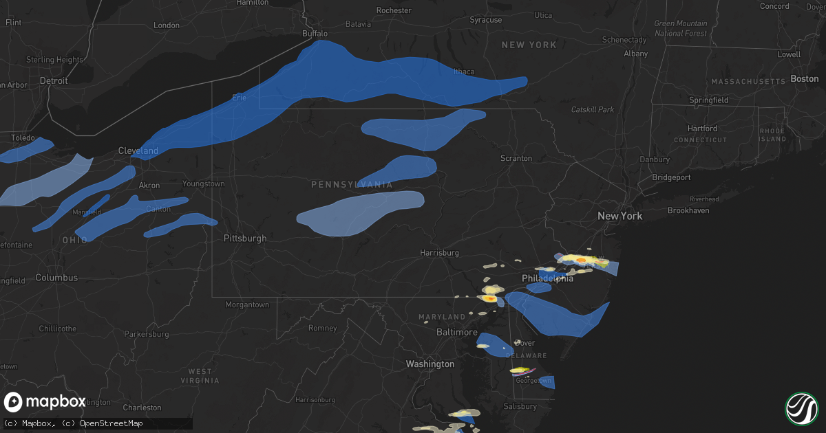
Hail Map in Pennsylvania on April 1, 2023
Get this storm
April 1 map
$229
one time, instant access
Download today. No call, no setup
Keep the $229
Bought the map and want the full workflow? Apply the entire $229 to a subscription within 7 days. None of it is wasted.
Every map, not just this one
This buys you this map. Subscription and you get every map we run, in the markets you choose from a few cities to whole states to nationwide. Plus real-time alerts the moment a storm fires.
Contact data
Name, contact info, occupancy, even credit band for addresses in the footprint. You go from where it hit to who to call.
Become the source they trust
Unlimited branding weather history reports on demand. You already have the documented answer ready for the property owner, and you are the one who showed up with it.
Property data and RoofTrace estimates
Pull up any address you have got, its value and the exact code rules for that jurisdiction, straight from One Click Code. Then RoofTrace estimates the squares, pitch, and roof value, priced the way you price.
Storm reports in Pennsylvania
Pennsylvania
| Date | Description |
|---|---|
| 04/01/20236:07 PM CDT | A local report indicates 62 MPH wind near PHILADELPHIA INTERNATIO |
| 04/01/20235:54 PM CDT | Picture of quarter sized hail in lower makefield township. Time estimated via radar. |
| 04/01/20235:54 PM CDT | Quarter sized hail pictures from trained spotter. |
| 04/01/20235:51 PM CDT | Pictures of trees and fencing down in langhorne... Pa. Time estimated via radar. |
| 04/01/20235:49 PM CDT | A local report indicates 68 MPH wind near LOWER MORELAND TWP |
| 04/01/20235:48 PM CDT | Large tree downed blocking bells mill road in andorra section of philadelphia county. Time estimated via radar. |
| 04/01/20235:42 PM CDT | Us-422 closed in both directions between the pa-23 bridgeport and pa 363 at audubon exits in upper merion township... Montgomery county due to downed utility lines. Tim |
| 04/01/20235:40 PM CDT | Large tree down on barren hill road just west of ridge pike. |
| 04/01/20235:40 PM CDT | Report from mping: quarter |
| 04/01/20235:30 PM CDT | Picture of large trees downed in honey brook... Pa. Time estimated via radar. |
| 04/01/20234:35 PM CDT | Tree and wires down. |
| 04/01/20234:11 PM CDT | Large tree limb fell onto front of a house. |
| 04/01/20234:05 PM CDT | Tree down at lickdale campground. |
| 04/01/20233:05 PM CDT | Trees down. |
| 04/01/20232:50 PM CDT | Multiple trees down... One on a barn roof. |
| 04/01/20232:38 PM CDT | Trees down. |
| 04/01/20232:35 PM CDT | A local report indicates 58 MPH wind near 3 NNE LEONARD HARRISON |
| 04/01/20232:35 PM CDT | Trees down along route 6. |
| 04/01/20232:30 PM CDT | Measured at top of beaver stadium. |
| 04/01/20232:25 PM CDT | *** 1 inj *** branches from a fallen tree struck and injured a female's neck. Time estimated from radar. |
| 04/01/20232:15 PM CDT | Power poles damaged. |
| 04/01/20232:15 PM CDT | Pictures provided of 3 snapped trees and one uprooted tree on wren street. Time estimated from radar. |
| 04/01/20232:10 PM CDT | Tree down on wires. |
| 04/01/20232:09 PM CDT | Wires down. |
| 04/01/20232:08 PM CDT | Wires down. |
| 04/01/20232:00 PM CDT | Trees down at sinnemahoning state park. |
| 04/01/20231:55 PM CDT | Mobile home unit rolled over on its roof remaining essentially intact. Report relayed via social media. |
| 04/01/20231:51 PM CDT | Tree down. |
| 04/01/20231:50 PM CDT | Tree down on route 59. |
| 04/01/20231:45 PM CDT | Telephone poles snapped and wires down on university drive. |
| 04/01/20231:40 PM CDT | Tree and wires down. |
| 04/01/20231:40 PM CDT | Trees and wires down. |
| 04/01/20231:40 PM CDT | Trees down with wires. |
| 04/01/20231:40 PM CDT | Trees down across benshoff hill road. |
| 04/01/20231:35 PM CDT | Trees down on wires. |
| 04/01/20231:35 PM CDT | Tree down across 66. |
| 04/01/20231:33 PM CDT | Telephone pole snapped on john street |
| 04/01/20231:32 PM CDT | Trees down and uprooted along scott lane. Time based off radar. |
| 04/01/20231:31 PM CDT | Trees down on moccasin drive... Thompsonville... And old washington road. Time based on the radar. |
| 04/01/20231:30 PM CDT | Trees and lines down in harmony township. Time estimated from radar. |
| 04/01/20231:20 PM CDT | Trees down on several roads in and around marienville. Time estimated from radar. |
| 04/01/20231:16 PM CDT | Trees down on conewango ave. |
| 04/01/20231:15 PM CDT | Approximately six inch diameter branch blown off of a tree. Time estimated. |
| 04/01/20231:15 PM CDT | Tree and wires down. |
| 04/01/20231:15 PM CDT | Tree on power lines along route 286 near the prison. Time based off the radar. |
| 04/01/20231:13 PM CDT | Tree down on route 286 and sample run. Picture provided. Time based off the radar. |
| 04/01/20231:11 PM CDT | Big tree down on grandview ave and 6th street. Power line pole also leaning in picture. Time based off the radar. |
| 04/01/20231:11 PM CDT | Multiple trees dwon on railroad tracks near 25 lewis street. Time based off the radar. |
| 04/01/20231:11 PM CDT | Trees down near indiana country club on wren road. Time based off the radar. |
| 04/01/20231:11 PM CDT | Big tree down on grandview ave and 6th street. Power line pole also leaning in picture. Time based off the rad |
| 04/01/20231:10 PM CDT | Multiple trees down. |
| 04/01/20231:08 PM CDT | Roof blown off of old hopwood gym |
| 04/01/20231:08 PM CDT | Roof blown off of old hopwood gym |
| 04/01/20231:07 PM CDT | Numerous trees down around the city. Roads impacted were: hemlock acres road... Goodville road... And north point park road. Time based on the radar. |
| 04/01/20231:05 PM CDT | A church on south 9th street lost some of its roof and a nearby telephone pole was snapped. Time estimated from radar. |
| 04/01/20231:05 PM CDT | Tree blocking truittsburg road. Time estimated |
| 04/01/20231:01 PM CDT | Multiple trees down on oak ridge hill. Time based off the radar. |
| 04/01/20231:00 PM CDT | 60 foot tall tree partially uprooted on to power lines on meadow avenue. Time estimated from radar. |
| 04/01/20231:00 PM CDT | Tree down across the road. |
| 04/01/20231:00 PM CDT | Shannon tipple road cloased with power lines and tree down. Picture provided. Time based off the radar. |
| 04/01/20231:00 PM CDT | Trees and utility lines down across several roads... Including pictured tree on wires at redbank valley high school. Time estimated from radar. |
| 04/01/202312:57 PM CDT | Power pole damage on maple ave and ridge ave. Picture from county police. Time based off the radar. |
| 04/01/202312:50 PM CDT | Many reports of tree and power line damage across the county... A few examples include aleppo township... Jefferson... And franklin township. Time estimated. |
| 04/01/202312:49 PM CDT | Big pine tree down by login cabin restaurant along bredinsburg road. |
| 04/01/202312:49 PM CDT | Trees and power lines down near 1400 block of big bend road in scrubgrass township. |
| 04/01/202312:48 PM CDT | *delayed report* numerous calls for downed trees and power-lines came in to dispatch from across crawford county. Power outages were most concentrated near riceville an |
| 04/01/202312:47 PM CDT | Tree down on mt royal blvd. Time based off the radar. |
| 04/01/202312:47 PM CDT | Large branches/small trees snapped. Picture provided. |
| 04/01/202312:45 PM CDT | Four trees down. Time estimated from radar. |
| 04/01/202312:45 PM CDT | Four trees down. Time estimated from radar. Ar. |
| 04/01/202312:45 PM CDT | Tree down on cherry drive. Picture provided. |
| 04/01/202312:45 PM CDT | Numerous trees down on bonniebrook road |
| 04/01/202312:45 PM CDT | Siding from a home partially ripped off and tree down. |
| 04/01/202312:45 PM CDT | Tree down on cherry drive. Picture provided. |
| 04/01/202312:45 PM CDT | Siding blown off of a house and some large branches down on lakeview road. Time estimated from radar. |
| 04/01/202312:42 PM CDT | Tree down on hulton road. Time based off the radar. |
| 04/01/202312:41 PM CDT | Siding removed from a portion of a home. Time based off the radar. |
| 04/01/202312:41 PM CDT | Tree down on meridian road. Picture provided. Time based off the radar. |
| 04/01/202312:41 PM CDT | 8 pine trees down near haine elementary school. Picture provided. Time based off the radar. |
| 04/01/202312:40 PM CDT | Tree down. Time estimated. |
| 04/01/202312:40 PM CDT | Tree fell on property on danbury street. Time estimated from radar. |
| 04/01/202312:39 PM CDT | Tree down on brandywine dr. In cranberry twp. Picture provided. Time based off the radar. |
| 04/01/202312:39 PM CDT | Tree caught in wires and smoking on yankee ridge road. Time based on radar. |
| 04/01/202312:37 PM CDT | Measured gust of 76 mph on davis anemometer. Shingles blown off of roof. |
| 04/01/202312:37 PM CDT | Asos station kgkj meadville. |
| 04/01/202312:37 PM CDT | Corrected to thunderstorm wind gust |
| 04/01/202312:36 PM CDT | *delayed report* large pine tree fell onto a road and took down power-lines. Time estimated via radar. |
| 04/01/202312:35 PM CDT | Pine trees down. Time estimated by the radar. |
| 04/01/202312:35 PM CDT | Roof damage to business between duncan alley and grand ave. Video surveillance footage available. Time estimated based on radar. . |
| 04/01/202312:33 PM CDT | Tree uprooted. Time estimated by radar. |
| 04/01/202312:33 PM CDT | Trees uprooted at south hills village mall. Small hail noted. Time based off the radar. |
| 04/01/202312:32 PM CDT | Tree down behind stephen phillips apartments. Time based off the radar. |
| 04/01/202312:31 PM CDT | Tree down on 10th street. Picture provided. Time based off the radar. |
| 04/01/202312:30 PM CDT | Tree blown down in monaca/center township cemetry. |
| 04/01/202312:28 PM CDT | Two trees down in observer yard. Pictures provided. |
| 04/01/202312:27 PM CDT | *delayed report* numerous calls for downed trees and power-lines came into dispatch from across erie county. Power outages were most concentrated just east of i-79 in m |
| 04/01/202312:25 PM CDT | Siding blown off house and tree down in yard. Time estimated from radar. |
| 04/01/202312:25 PM CDT | Oak trees down and branches displaced around the city. Time based on the radar. |
| 04/01/202312:22 PM CDT | Trees down on wires. Radar estimated time. |
| 04/01/202312:21 PM CDT | Gust recorded near i90 and route 19. |
| 04/01/202312:20 PM CDT | Several large branches down on wyngate road. Picture provided. |
| 04/01/202312:20 PM CDT | Trees down in west salem township. Time estimated from radar. |
| 04/01/202312:20 PM CDT | Several large branches down on wyngate road. Picture provided. |
| 04/01/202312:20 PM CDT | Trees down in west middlesex... Including on bedford road... Causing power outages. Time estimated from radar. |
| 04/01/202312:20 PM CDT | Trees down in hermitage. Time estimated from radar. |
| 04/01/202312:19 PM CDT | Partial collapse of a structure on mercer road |
| 04/01/202312:13 PM CDT | Multiple trees down between leeepr and cook forest along route 36. |
| 04/01/202312:13 PM CDT | 10 pine tree snapped halfway up near route 20 and imperial parkway. |
| 04/01/202312:10 PM CDT | Numerous trees uprooted. |
| 03/31/20238:21 PM CDT | Trees down |
All States Impacted by Hail Map on April 1, 2023
Cities Impacted by Hail Map on April 1, 2023
- Corydon, KY
- Henderson, KY
- Robards, KY
- Sturgis, KY
- Morganfield, KY
- Murray, KY
- Hollow Rock, TN
- Bruceton, TN
- Camden, TN
- Mansfield, TN
- Big Sandy, TN
- Charleston, MS
- Enid, MS
- Blue Springs, MS
- Guntown, MS
- Bluffton, OH
- Harrod, OH
- Jenera, OH
- Forest, OH
- Arlington, OH
- Ada, OH
- Williamstown, OH
- Findlay, OH
- Mount Cory, OH
- Rawson, OH
- Benton Ridge, OH
- Liberty Center, OH
- McClure, OH
- Napoleon, OH
- Grand Rapids, OH
- Weston, OH
- Bowling Green, OH
- Waterville, OH
- Whitehouse, OH
- Haskins, OH
- Pemberville, OH
- Tontogany, OH
- Perrysburg, OH
- Dunbridge, OH
- Stony Ridge, OH
- Millbury, OH
- Walbridge, OH
- Luckey, OH
- Upper Sandusky, OH
- Carey, OH
- McCutchenville, OH
- Wharton, OH
- Vanlue, OH
- Mount Blanchard, OH
- Sycamore, OH
- Alvada, OH
- Arcadia, OH
- Tiffin, OH
- Bascom, OH
- New Riegel, OH
- Fostoria, OH
- La Rue, OH
- New Bloomington, OH
- Marion, OH
- Morral, OH
- Caledonia, OH
- Bucyrus, OH
- Bloomville, OH
- Republic, OH
- Green Springs, OH
- Elmore, OH
- Genoa, OH
- Woodville, OH
- Graytown, OH
- Williston, OH
- Curtice, OH
- Clay Center, OH
- Martin, OH
- Oak Harbor, OH
- Rocky Ridge, OH
- Port Clinton, OH
- Clyde, OH
- Attica, OH
- Bellevue, OH
- Crestline, OH
- Galion, OH
- Tiro, OH
- New Washington, OH
- Shelby, OH
- Willard, OH
- Monroeville, OH
- Castalia, OH
- Sandusky, OH
- Huron, OH
- Collins, OH
- Norwalk, OH
- Milan, OH
- Berlin Heights, OH
- Plymouth, OH
- Shiloh, OH
- Greenwich, OH
- Sullivan, OH
- Nova, OH
- Wellington, OH
- New London, OH
- Vermilion, OH
- Mansfield, OH
- Ashland, OH
- Polk, OH
- Homerville, OH
- Spencer, OH
- Litchfield, OH
- West Salem, OH
- Lagrange, OH
- Grafton, OH
- Lodi, OH
- Medina, OH
- Valley City, OH
- Brunswick, OH
- Strongsville, OH
- Hinckley, OH
- Columbia Station, OH
- North Royalton, OH
- Brecksville, OH
- Richfield, OH
- Broadview Heights, OH
- Fredericktown, OH
- Mount Gilead, OH
- Bellville, OH
- Butler, OH
- Perrysville, OH
- Lucas, OH
- Loudonville, OH
- Jeromesville, OH
- Shreve, OH
- Wooster, OH
- Lakeville, OH
- Apple Creek, OH
- Smithville, OH
- Orrville, OH
- Sterling, OH
- Marshallville, OH
- Rittman, OH
- Doylestown, OH
- Cleveland, OH
- Independence, OH
- Maple Heights, OH
- Bedford, OH
- Euclid, OH
- Beachwood, OH
- Chagrin Falls, OH
- Solon, OH
- Wickliffe, OH
- Eastlake, OH
- Willoughby, OH
- Mentor, OH
- Gates Mills, OH
- Perry, OH
- Novelty, OH
- Grand River, OH
- Painesville, OH
- Chardon, OH
- Chesterland, OH
- Madison, OH
- Rome, OH
- Thompson, OH
- Montville, OH
- Newbury, OH
- Huntsburg, OH
- Geneva, OH
- Rock Creek, OH
- Ashtabula, OH
- North Kingsville, OH
- Conneaut, OH
- Austinburg, OH
- Kingsville, OH
- Jefferson, OH
- Windsor, OH
- Burton, OH
- Orwell, OH
- Middlefield, OH
- Dorset, OH
- Williamsfield, OH
- Pierpont, OH
- Andover, OH
- Albion, PA
- Conneautville, PA
- East Springfield, PA
- Girard, PA
- Lake City, PA
- Cranesville, PA
- Springboro, PA
- West Springfield, PA
- Fairview, PA
- Erie, PA
- Linesville, PA
- North Springfield, PA
- Dover, OH
- New Philadelphia, OH
- Sugarcreek, OH
- Sherrodsville, OH
- Mineral City, OH
- Dellroy, OH
- Somerdale, OH
- Carrollton, OH
- Magnolia, OH
- Mechanicstown, OH
- Minerva, OH
- Salineville, OH
- Hanoverton, OH
- Kensington, OH
- Summitville, OH
- East Rochester, OH
- Hammondsville, OH
- Lisbon, OH
- Wellsville, OH
- East Liverpool, OH
- Newell, WV
- Chester, WV
- Georgetown, PA
- Midland, PA
- Industry, PA
- Hookstown, PA
- Shippingport, PA
- Aliquippa, PA
- Cambridge Springs, PA
- Saegertown, PA
- Meadville, PA
- Hartstown, PA
- Jamestown, PA
- Edinboro, PA
- Harmonsburg, PA
- McKean, PA
- Venango, PA
- Conneaut Lake, PA
- Wattsburg, PA
- Union City, PA
- Waterford, PA
- Ripley, NY
- North East, PA
- Harborcreek, PA
- Centerville, PA
- Findley Lake, NY
- Guys Mills, PA
- Sherman, NY
- Townville, PA
- Corry, PA
- Spartansburg, PA
- Clymer, NY
- Chautauqua, NY
- Fredonia, NY
- Brocton, NY
- Bear Lake, PA
- Westfield, NY
- Dunkirk, NY
- Van Buren Point, NY
- Stockton, NY
- Mayville, NY
- Dewittville, NY
- Ashville, NY
- Columbus, PA
- Portland, NY
- Panama, NY
- Arlington, AL
- Thomaston, AL
- Catherine, AL
- Pine Hill, AL
- Camden, AL
- Americus, GA
- Parrott, GA
- Smithville, GA
- Preston, GA
- Plains, GA
- Dawson, GA
- Alberta, AL
- Magnolia, AL
- Bemus Point, NY
- Cassadaga, NY
- Celoron, NY
- Lakewood, NY
- Stow, NY
- Gerry, NY
- Sinclairville, NY
- Jamestown, NY
- Sugar Grove, PA
- Lily Dale, NY
- Pittsfield, PA
- Spring Creek, PA
- Cherry Creek, NY
- Sheridan, NY
- Forestville, NY
- Silver Creek, NY
- Falconer, NY
- Frewsburg, NY
- Little Valley, NY
- Conewango Valley, NY
- Gowanda, NY
- Randolph, NY
- Perrysburg, NY
- South Dayton, NY
- Irving, NY
- Dayton, NY
- Salamanca, NY
- Cattaraugus, NY
- Kennedy, NY
- Lake View, NY
- North Collins, NY
- Hamburg, NY
- Eden, NY
- Lawtons, NY
- Collins, NY
- Angola, NY
- Derby, NY
- Machias, NY
- Delevan, NY
- East Concord, NY
- East Otto, NY
- Boston, NY
- Ellicottville, NY
- Springville, NY
- West Valley, NY
- Holland, NY
- Chaffee, NY
- Yorkshire, NY
- Orchard Park, NY
- Colden, NY
- Sardinia, NY
- Glenwood, NY
- Arcade, NY
- West Falls, NY
- Java Village, NY
- South Wales, NY
- Varysburg, NY
- East Aurora, NY
- Java Center, NY
- North Java, NY
- Strykersville, NY
- Buffalo, NY
- Elma, NY
- Osceola Mills, PA
- Philipsburg, PA
- Ramey, PA
- La Jose, PA
- New Millport, PA
- Smithmill, PA
- Morrisdale, PA
- Glen Hope, PA
- Irvona, PA
- Madera, PA
- West Decatur, PA
- Coalport, PA
- Brisbin, PA
- Curwensville, PA
- Houtzdale, PA
- Beccaria, PA
- Olanta, PA
- Glen Campbell, PA
- Mahaffey, PA
- Cherry Tree, PA
- Burnside, PA
- Westover, PA
- Marion Center, PA
- Starford, PA
- Dixonville, PA
- Clymer, PA
- Arcadia, PA
- Commodore, PA
- Indiana, PA
- Home, PA
- Rochester Mills, PA
- Hillsdale, PA
- Ernest, PA
- Emeigh, PA
- Saint Benedict, PA
- Penn Run, PA
- Northern Cambria, PA
- Ebensburg, PA
- Hastings, PA
- Strongstown, PA
- Mentcle, PA
- Spangler, PA
- Nicktown, PA
- Heilwood, PA
- Marsteller, PA
- Alverda, PA
- Patton, PA
- Elmora, PA
- Colver, PA
- Carrolltown, PA
- Saint Boniface, PA
- Loretto, PA
- Ashville, PA
- Flinton, PA
- Chest Springs, PA
- Gallitzin, PA
- Dysart, PA
- Duncansville, PA
- Cresson, PA
- Fallentimber, PA
- Altoona, PA
- Bellwood, PA
- Hollidaysburg, PA
- Blandburg, PA
- Tipton, PA
- Tyrone, PA
- Munson, PA
- Hawk Run, PA
- Bellefonte, PA
- Howard, PA
- Port Matilda, PA
- Pennsylvania Furnace, PA
- Warriors Mark, PA
- Alexandria, PA
- University Park, PA
- Snow Shoe, PA
- Spruce Creek, PA
- Milesburg, PA
- Fleming, PA
- Sandy Ridge, PA
- Julian, PA
- State College, PA
- Lanse, PA
- Pine Grove Mills, PA
- Centre Hall, PA
- Lemont, PA
- Petersburg, PA
- Boalsburg, PA
- Williamsburg, PA
- Huntingdon, PA
- Spring Mills, PA
- Great Valley, NY
- Hinsdale, NY
- Allegany, NY
- Cuba, NY
- Bolivar, NY
- Franklinville, NY
- Kill Buck, NY
- Olean, NY
- Portville, NY
- Limestone, NY
- Friendship, NY
- Caneadea, NY
- Belfast, NY
- Black Creek, NY
- Houghton, NY
- Freedom, NY
- Farmersville Station, NY
- Rushford, NY
- Dalton, NY
- Swain, NY
- Hunt, NY
- Fillmore, NY
- Angelica, NY
- Portageville, NY
- Nunda, NY
- Gainesville, NY
- Bliss, NY
- Castile, NY
- Mill Hall, PA
- North Bend, PA
- Lock Haven, PA
- Cammal, PA
- Renovo, PA
- Beech Creek, PA
- Frenchville, PA
- Moshannon, PA
- Orviston, PA
- Karthaus, PA
- Pottersdale, PA
- Clarence, PA
- Millheim, PA
- Woodward, PA
- Madisonburg, PA
- Aaronsburg, PA
- Coburn, PA
- Rebersburg, PA
- Loganton, PA
- Waterville, PA
- Jersey Shore, PA
- Jersey Mills, PA
- Alfred, NY
- Canisteo, NY
- Cameron Mills, NY
- Scio, NY
- Campbell, NY
- Arkport, NY
- Almond, NY
- Alfred Station, NY
- Canaseraga, NY
- Savona, NY
- Bath, NY
- Cameron, NY
- Hornell, NY
- Avoca, NY
- Dansville, NY
- Andover, NY
- Belmont, NY
- Cohocton, NY
- Wayland, NY
- Wellsville, NY
- Roulette, PA
- Coudersport, PA
- Genesee, PA
- Galeton, PA
- Ulysses, PA
- Sabinsville, PA
- Westfield, PA
- Gaines, PA
- Morris, PA
- Liberty, PA
- Wellsboro, PA
- Trout Run, PA
- Blossburg, PA
- Ralston, PA
- Roaring Branch, PA
- Cogan Station, PA
- Mansfield, PA
- Morris Run, PA
- Tioga, PA
- Middlebury Center, PA
- Troy, PA
- Mainesburg, PA
- Canton, PA
- Covington, PA
- Alba, PA
- Columbia Cross Roads, PA
- Millerton, PA
- Linden, PA
- Avis, PA
- Williamsport, PA
- Milroy, PA
- Wray, GA
- Ocilla, GA
- Ambrose, GA
- Douglas, GA
- Granville Summit, PA
- Shunk, PA
- Forksville, PA
- Dushore, PA
- East Smithfield, PA
- Monroeton, PA
- Ulster, PA
- Towanda, PA
- Milan, PA
- New Albany, PA
- Athens, PA
- Sayre, PA
- Gillett, PA
- Laurelton, PA
- Mifflinburg, PA
- Millmont, PA
- McClure, PA
- Beavertown, PA
- Beaver Springs, PA
- Middleburg, PA
- Vancleave, MS
- Jasper, NY
- Painted Post, NY
- Addison, NY
- Greenwood, NY
- Corning, NY
- Pine City, NY
- Big Flats, NY
- Elmira, NY
- Pine Valley, NY
- Horseheads, NY
- Beaver Dams, NY
- Trumansburg, NY
- Dundee, NY
- Bradford, NY
- Millport, NY
- Watkins Glen, NY
- Burdett, NY
- Rock Stream, NY
- Hammondsport, NY
- Odessa, NY
- Montour Falls, NY
- Hector, NY
- Lodi, NY
- Interlaken, NY
- Branchport, NY
- Himrod, NY
- Prattsburgh, NY
- Penn Yan, NY
- Pulteney, NY
- Naples, NY
- Atlanta, NY
- Keuka Park, NY
- Breesport, NY
- Erin, NY
- Alpine, NY
- Cayuta, NY
- Lowman, NY
- Wellsburg, NY
- Waverly, NY
- Chemung, NY
- Newfield, NY
- Lockwood, NY
- Van Etten, NY
- Ithaca, NY
- Spencer, NY
- Nichols, NY
- Barton, NY
- Willseyville, NY
- Apalachin, NY
- Owego, NY
- Candor, NY
- Chenango Forks, NY
- Dryden, NY
- Glen Aubrey, NY
- Newark Valley, NY
- Port Crane, NY
- Slaterville Springs, NY
- Castle Creek, NY
- Whitney Point, NY
- Richford, NY
- Lisle, NY
- Berkshire, NY
- Afton, NY
- Harpursville, NY
- Brooktondale, NY
- Maine, NY
- Greene, NY
- Johnson City, NY
- Freeville, NY
- Binghamton, NY
- Bainbridge, NY
- Endicott, NY
- Rome, PA
- Wysox, PA
- Montoursville, PA
- Warren Center, PA
- Little Meadows, PA
- Le Raysville, PA
- Oxford, NY
- Mount Upton, NY
- Guilford, NY
- South New Berlin, NY
- Federalsburg, MD
- Greenwood, DE
- Denton, MD
- Bridgeville, DE
- Lincoln, DE
- Ellendale, DE
- Feasterville Trevose, PA
- Langhorne, PA
- Richboro, PA
- Southampton, PA
- Newtown, PA
- Warminster, PA
- Peach Bottom, PA
- Nottingham, PA
- Rising Sun, MD
- Colora, MD
- North East, MD
- Levittown, PA
- Bensalem, PA
- Morrisville, PA
- Fairless Hills, PA
- Willacoochee, GA
- Alapaha, GA
- Bonifay, FL
- Caryville, FL
- Chipley, FL
- Trenton, NJ
- Bristol, PA
- Riverton, NJ
- Palmyra, NJ
- Moorestown, NJ
- Riverside, NJ
- Florence, NJ
- Bordentown, NJ
- Chesterfield, NJ
- Robbinsville, NJ
- Allentown, NJ
- Cream Ridge, NJ
- Millstone Township, NJ
- Hightstown, NJ
- Elkton, MD
- Englishtown, NJ
- Freehold, NJ
- Roosevelt, NJ
- Jackson, NJ
- New Egypt, NJ
- Lakewood, NJ
- Manchester Township, NJ
- Toms River, NJ
- Howell, NJ
- Philadelphia, PA
- Gladwyne, PA
- Glenside, PA
- Wyncote, PA
- Elkins Park, PA
- Bala Cynwyd, PA
- Merion Station, PA
- Narberth, PA
- Cheltenham, PA
- Lafayette Hill, PA
- Conshohocken, PA
- Havertown, PA
- Ardmore, PA
- Wynnewood, PA
- Upper Darby, PA
- Camden, NJ
- Pennsauken, NJ
- Merchantville, NJ
- Mount Laurel, NJ
- Willingboro, NJ
- Mount Holly, NJ
- Rancocas, NJ
- Maple Shade, NJ
- Hainesport, NJ
- Wrightstown, NJ
- Chester, PA
- Brookhaven, PA
- Swarthmore, PA
- Norwood, PA
- Folsom, PA
- Ridley Park, PA
- Sharon Hill, PA
- Folcroft, PA
- Gibbstown, NJ
- Crum Lynne, PA
- Woodlyn, PA
- Wallingford, PA
- Prospect Park, PA
- Holmes, PA
- Glenolden, PA
- Westville, NJ
- Bridgeport, NJ
- Essington, PA
- Paulsboro, NJ
- National Park, NJ
- Thorofare, NJ
- Swedesboro, NJ
- Morton, PA
- Marcus Hook, PA
- Media, PA
- Wilmington, DE
- Aston, PA
- Garnet Valley, PA
- Claymont, DE
- Yorklyn, DE
- Newark, DE
- Hockessin, DE
- Landenberg, PA
- Middletown, DE
- New Castle, DE
- Bear, DE
- Delaware City, DE
- Pennsville, NJ
- Penns Grove, NJ
- Salem, NJ
- Woodstown, NJ
- Newfield, NJ
- Mullica Hill, NJ
- Williamstown, NJ
- Malaga, NJ
- Elmer, NJ
- Newtonville, NJ
- Pedricktown, NJ
- Franklinville, NJ
- Monroeville, NJ
- Clayton, NJ
- Bridgeton, NJ
- Alloway, NJ
- Millville, NJ
- Minotola, NJ
- Buena, NJ
- Shiloh, NJ
- Greenwich, NJ
- Vineland, NJ
- Landisville, NJ
- Cedarville, NJ
- Clarksboro, NJ
- Mickleton, NJ
- Wenonah, NJ
- Mantua, NJ
- Woodbury Heights, NJ
- Mount Royal, NJ
- Woodbury, NJ
- Sewell, NJ
- Bellmawr, NJ
- Gloucester City, NJ
- Dorothy, NJ
- Milmay, NJ
- Richland, NJ
- Newport, NJ
- Mays Landing, NJ
- Hammonton, NJ
- Lavallette, NJ
- Brick, NJ
- Spring Lake, NJ
- Belmar, NJ
- Mantoloking, NJ
- Point Pleasant Beach, NJ
- Allenwood, NJ
- Sea Girt, NJ
- Brielle, NJ
- Manasquan, NJ
- Farmingdale, NJ
- Harrington, DE
- Dorchester, NJ
- Egg Harbor Township, NJ
- Cape May, NJ
- Wildwood, NJ
- Ocean View, NJ
- Villas, NJ
- Delmont, NJ
- Woodbine, NJ
- Mauricetown, NJ
- Leesburg, NJ
- Cape May Court House, NJ
- Rio Grande, NJ
- Port Norris, NJ
- Port Elizabeth, NJ
- Heislerville, NJ
- Fortescue, NJ
- Estell Manor, NJ
- Brigantine, NJ
- Pleasantville, NJ
- Linwood, NJ
- Absecon, NJ
- Somers Point, NJ
- Northfield, NJ
- Atlantic City, NJ
- Ocean City, NJ
- Margate City, NJ
- Ventnor City, NJ
- Longport, NJ
- Marmora, NJ
- Chestertown, MD
- Worton, MD
- Rock Hall, MD
- Centreville, MD
- Church Hill, MD
- Goldsboro, MD
- Queen Anne, MD
- Marydel, MD
- Barclay, MD
- Marydel, DE
- Camden Wyoming, DE
- Ingleside, MD
- Felton, DE
- Sudlersville, MD
- Henderson, MD
- Ridgely, MD
- Greensboro, MD
- Great Mills, MD
- Patuxent River, MD
- California, MD
- Leonardtown, MD
- Valley Lee, MD
- Lexington Park, MD
- Callaway, MD
- Hollywood, MD
- Saint Inigoes, MD
- Drayden, MD
- Park Hall, MD
- Dameron, MD
- Mechanicsville, VA
- Ridge, MD
- Heathsville, VA
- Kinsale, VA
- Piney Point, MD
- Callao, VA
- Lottsburg, VA
- Scotland, MD
- Farnham, VA
- Lancaster, VA
- Reedville, VA
- Burgess, VA
- King William, VA
- New Kent, VA
- West Point, VA
- Lewes, DE
- Harbeson, DE
- Georgetown, DE
- Milton, DE
- Rehoboth Beach, DE
- Millsboro, DE
- Bethany Beach, DE
- Kilmarnock, VA
- Weems, VA
- Saluda, VA
- Urbanna, VA
- Church View, VA
- Mascot, VA
- Shacklefords, VA
- Little Plymouth, VA
- Mattaponi, VA
- Barnegat Light, NJ
- Manahawkin, NJ
- West Creek, NJ
- Port Republic, NJ
- Tuckerton, NJ
- Beach Haven, NJ
- Egg Harbor City, NJ
- Henrico, VA
- Richmond, VA
- Glen Allen, VA
- Kirkwood, PA
- Oxford, PA
- Quarryville, PA
- Fallston, MD
- Bel Air, MD
- Jobstown, NJ
- Joint Base Mdl, NJ
- Cookstown, NJ
- Christiana, PA
- Strasburg, PA
- Paradise, PA
- Ronks, PA
- Loretto, VA
- Caret, VA
- Cherry Hill, NJ
- Tappahannock, VA
- Saint Stephens Church, VA
- New Holland, PA
- East Earl, PA
- Narvon, PA
- Leola, PA
- Hartly, DE
- Dover, DE
- Honey Brook, PA
- Elverson, PA
- Woodbine, MD
- Mount Airy, MD
- Fawn Grove, PA
- Stewartstown, PA
- Parkton, MD
- Conowingo, MD
- Port Deposit, MD
- Havre De Grace, MD
- Aberdeen, MD
- Aberdeen Proving Ground, MD
- West Grove, PA
- Cochranville, PA
- Lincoln University, PA
- Lusby, MD
- Avenue, MD
- Solomons, MD
- Jenkintown, PA
- Hooksett, NH
- Dunnsville, VA
- Bruington, VA
- Warsaw, VA
- Spring City, PA
- Phoenixville, PA
- Pottstown, PA
- Tall Timbers, MD
- Bowling Green, VA
- Hague, VA
- Montross, VA
- Colonial Beach, VA
- Port Royal, VA
- Champlain, VA
- Hustle, VA
- Burlington, NJ
- Columbus, NJ
- Lakehurst, NJ
- Perryville, MD
- Cranbury, NJ
- Monroe Township, NJ
- Jamaica, VA
- Whiteford, MD
- Delta, PA
- Princeton Junction, NJ
- Lawrence Township, NJ
- Wayne, PA
- Bryn Mawr, PA
- Huntingdon Valley, PA
- King Of Prussia, PA
- Villanova, PA
- Newtown, VA
- Milford, VA
- Aylett, VA
- Ruther Glen, VA
- Water View, VA
- Gloucester, VA
- Sandston, VA
- Quinton, VA
- Providence Forge, VA
- Locust Hill, VA
- Mount Vernon, OH
- Glenmont, OH
- Howard, OH
- Danville, OH
- Fredericksburg, OH
- Big Prairie, OH
- Millersburg, OH
- Holmesville, OH
- Mount Eaton, OH
- Navarre, OH
- Dalton, OH
- Dundee, OH
- North Lawrence, OH
- Massillon, OH
- Canton, OH
- Canal Fulton, OH
- East Canton, OH
- Damascus, OH
- Sebring, OH
- North Canton, OH
- Paris, OH
- Homeworth, OH
- Clinton, OH
- Beloit, OH
- Salem, OH
- Alliance, OH
- Louisville, OH
- Middlebranch, OH


