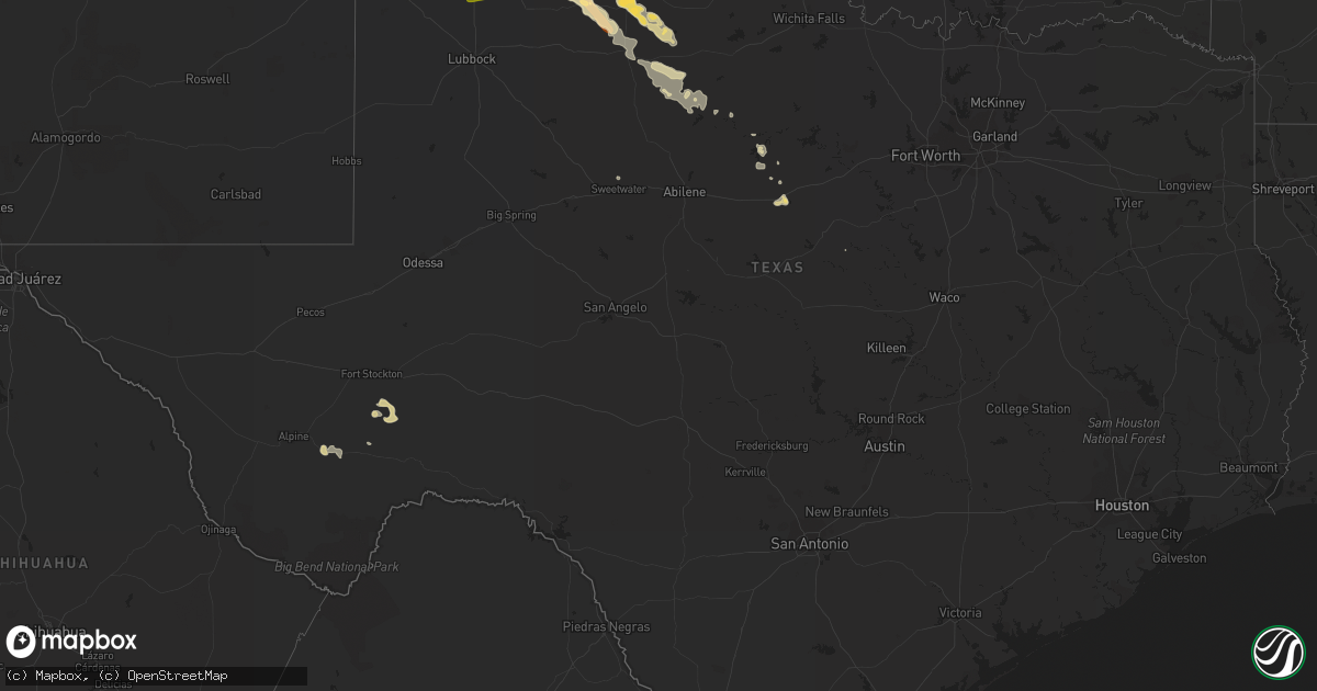
Hail Map in Texas on April 1, 2013
Get this storm
April 1 map
$229
one time, instant access
Download today. No call, no setup
Keep the $229
Bought the map and want the full workflow? Apply the entire $229 to a subscription within 7 days. None of it is wasted.
Every map, not just this one
This buys you this map. Subscription and you get every map we run, in the markets you choose from a few cities to whole states to nationwide. Plus real-time alerts the moment a storm fires.
Contact data
Name, contact info, occupancy, even credit band for addresses in the footprint. You go from where it hit to who to call.
Become the source they trust
Unlimited branding weather history reports on demand. You already have the documented answer ready for the property owner, and you are the one who showed up with it.
Property data and RoofTrace estimates
Pull up any address you have got, its value and the exact code rules for that jurisdiction, straight from One Click Code. Then RoofTrace estimates the squares, pitch, and roof value, priced the way you price.
Storm reports in Texas
Texas
| Date | Description |
|---|---|
| 04/01/20136:55 PM CDT | Widespread pea sized hail with occasional quarters |
| 04/01/20136:50 PM CDT | West texas mesonet |
| 04/01/20136:17 PM CDT | Ping pong ball size hail in city of paducah |
| 04/01/20136:17 PM CDT | Ping pong ball size via trained spotter |
| 04/01/20136:15 PM CDT | West texas mesonet |
| 04/01/20136:15 PM CDT | Quarter sized hail in city of paducah |
| 04/01/20135:35 PM CDT | 60 mph wind gust measured at the mesonet site. |
| 04/01/20135:25 PM CDT | West texas mesonet reported 67mph wind gust |
| 04/01/20135:20 PM CDT | Power pole snapped |
| 04/01/20135:13 PM CDT | West texas mesonet reported 59mph gust |
| 04/01/20135:10 PM CDT | A local report indicates 2.00 inch wind near 4 ESE SILVERTON |
| 04/01/20135:00 PM CDT | 6 power poles blown over. All pushed to the east |
| 04/01/20134:53 PM CDT | Damaged a metal barn. On ground for 5 minutes |
| 04/01/20134:50 PM CDT | Via nws coop |
| 04/01/20134:48 PM CDT | Windshield busted out with hail covering ground |
| 04/01/20134:41 PM CDT | Silverton high school net relayed by local media |
| 04/01/20134:40 PM CDT | Tornado touchdown reported by trained spotter |
| 04/01/20134:18 PM CDT | Crops damaged. Hail 4.5 inches deep covering roadway |
| 04/01/20134:17 PM CDT | Golfball size hail covering hwy 287 nw of childress |
| 04/01/20134:00 PM CDT | Windshield busted out of a vehicle |
| 04/01/20133:42 PM CDT | Quarter size hail reported in hale center by trained spotter |
| 04/01/20133:20 PM CDT | 4 cars blown off i27 |
| 04/01/20132:10 AM CDT | Quarter size hail 10 miles west of de leon |
| 04/01/20132:07 AM CDT | Quarter size hail in duster |
| 04/01/20131:12 AM CDT | Quarter size hail 5 miles southeast of dublin on fm 219 |
| 04/01/20131:10 AM CDT | Golfball size hail in dublin |
| 03/31/20139:30 PM CDT | Woodson fire department reported winds of 65 mph. |
| 03/31/20138:39 PM CDT | Jason at the fire dept in haskell reported 60 mph winds. |
| 03/31/20138:33 PM CDT | Mesonet station in wienert recorded sustained winds at 54 mph with 64 mph gust peak wind. |
| 03/31/20138:14 PM CDT | Hail lasted for another 11 minutes |
| 03/31/20138:08 PM CDT | 65 mph wind gusts. |
| 03/31/20138:06 PM CDT | A local report indicates 1.00 inch wind near MARATHON |
| 03/31/20138:04 PM CDT | A local report indicates 1.00 inch wind near KNOX CITY |
| 03/31/20137:42 PM CDT | 60 mph wind gust at this location. Sustained winds of 55 mph |
| 03/31/20137:24 PM CDT | Tree down |
| 03/31/20137:23 PM CDT | A local report indicates 1.00 inch wind near 7 W TRUSCOTT |
| 03/31/20137:00 PM CDT | Tin roof and doors blown off of barn |
Cities Impacted by Hail Map on April 1, 2013
- Tulia, TX
- Happy, TX
- Matador, TX
- Dickens, TX
- Paducah, TX
- Rule, TX
- Rochester, TX
- Caddo, TX
- Breckenridge, TX
- Plainview, TX
- Childress, TX
- Silverton, TX
- Quitaque, TX
- Memphis, TX
- Homestead, FL
- Seymour, TX
- Clarendon, TX
- Lakeview, TX
- Turkey, TX
- Cee Vee, TX
- Crowell, TX
- Fort Stockton, TX
- Quanah, TX
- Knox City, TX
- O'Brien, TX
- Old Glory, TX
- Ponte Vedra Beach, FL
- Eastland, TX
- Cisco, TX
- Stamford, TX
- Throckmorton, TX
- Marathon, TX
- Miami, FL
- Ranger, TX
- Hico, TX
- Lockney, TX
- Haskell, TX
- Woodson, TX
- Albany, TX
- Tell, TX
- Weinert, TX
- Palm Coast, FL
- Roaring Springs, TX
- Hale Center, TX
- Sweetwater, TX


