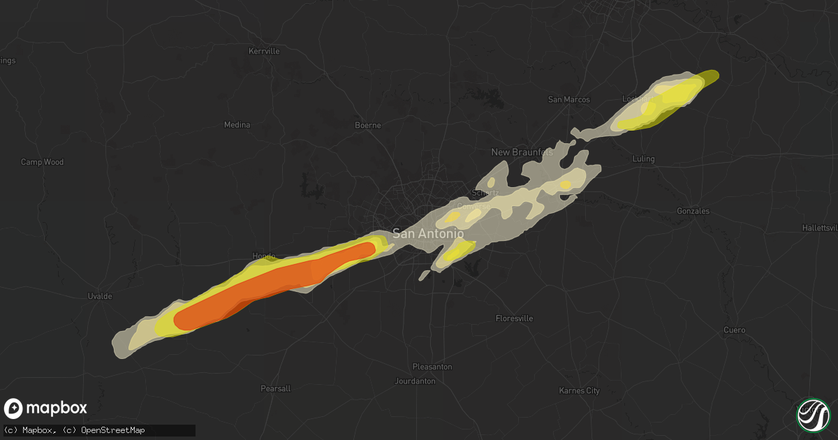
Hail Map in San Antonio, TX on March 28, 2018
Get this storm
March 28 map
$229
one time, instant access
Download today. No call, no setup
Keep the $229
Bought the map and want the full workflow? Apply the entire $229 to a subscription within 7 days. None of it is wasted.
Every map, not just this one
This buys you this map. Subscription and you get every map we run, in the markets you choose from a few cities to whole states to nationwide. Plus real-time alerts the moment a storm fires.
Contact data
Name, contact info, occupancy, even credit band for addresses in the footprint. You go from where it hit to who to call.
Become the source they trust
Unlimited branding weather history reports on demand. You already have the documented answer ready for the property owner, and you are the one who showed up with it.
Property data and RoofTrace estimates
Pull up any address you have got, its value and the exact code rules for that jurisdiction, straight from One Click Code. Then RoofTrace estimates the squares, pitch, and roof value, priced the way you price.
Storm reports in San Antonio, TX
San Antonio, TX
| Date | Description |
|---|---|
| 03/28/20189:45 AM CDT | A local report indicates 1.00 inch wind near 4 S SEA WORLD |
| 03/27/201810:20 PM CDT | Public report of quarter sized hail near the intersection of loop 410 and rigsby ave via ksat 12 facebook. |
All States Impacted by Hail Map on March 28, 2018
All Cities Impacted by Hail Map on March 28, 2018
- Louise, TX
- Ganado, TX
- El Campo, TX
- Devine, TX
- San Antonio, TX
- La Coste, TX
- Castroville, TX
- Sikes, LA
- Winnfield, LA
- Grayson, LA
- Orange Grove, TX
- Luling, TX
- Kennard, TX
- Rio Grande City, TX
- Campti, LA
- Saline, LA
- Goldonna, LA
- Yoakum, TX
- Kenedy, TX
- Montgomery, LA
- San Ygnacio, TX
- Zapata, TX
- Lexington, TX
- Lincoln, TX
- Pleasanton, TX
- Jourdanton, TX
- Floresville, TX
- Falls City, TX
- Jonesville, LA
- Edna, TX
- Laredo, TX
- Hebbronville, TX
- Garwood, TX
- Pickens, MS
- Benton, MS
- Durant, MS
- Goodman, MS
- Lexington, MS
- Vaughan, MS
- Santa Elena, TX
- Garciasville, TX
- Roma, TX
- Seguin, TX
- Lake Providence, LA
- Oak Grove, LA
- Rolling Fork, MS
- Gonzales, TX
- Tilden, TX
- Alice, TX
- Mayersville, MS
- Sondheimer, LA
- Transylvania, LA
- Refugio, TX
- Dale, TX
- Red Rock, TX
- Lockhart, TX
- Rockport, TX
- West, MS
- Ethel, MS
- Sabinal, TX
- D Hanis, TX
- Epps, LA
- Delhi, LA
- Cary, MS
- Tinsley, MS
- Yazoo City, MS
- Provencal, LA
- Robeline, LA
- Robstown, TX
- Mathiston, MS
- Cibolo, TX
- Merryville, LA
- Richmond, TX
- Sugar Land, TX
- Houston, TX
- Sandia, TX
- Cotulla, TX
- Encinal, TX
- Huffman, TX
- Karnes City, TX
- Kosciusko, MS
- Vaiden, MS
- Sallis, MS
- Louise, MS
- Holly Bluff, MS
- Anguilla, MS
- Moore, TX
- Converse, TX
- Matagorda, TX
- Portland, TX
- Ackerman, MS
- McQueeney, TX
- Jbsa Ft Sam Houston, TX
- Marion, TX
- Saint Hedwig, TX
- Schertz, TX
- Universal City, TX
- Jbsa Randolph, TX
- Rio Medina, TX
- Hondo, TX
- Mico, TX
- Goliad, TX
- Beeville, TX
- New Caney, TX
- Eagle Lake, TX
- Martindale, TX
- San Marcos, TX
- Kingsbury, TX
- Campbellton, TX
- Calliham, TX
- Whitsett, TX
- Odem, TX
- Sinton, TX
- Wharton, TX
- Atlanta, LA
- Tivoli, TX
- Dime Box, TX
- Cloutierville, LA
- Lena, LA
- Coila, MS
- Harrisonburg, LA
- Rayville, LA
- Cleveland, TX
- Port Lavaca, TX
- Victoria, TX
- Jbsa Lackland, TX
- Batesville, TX
- Uvalde, TX
- Adkins, TX
- Yancey, TX
- New Braunfels, TX
- La Vernia, TX
- Atascosa, TX
- Woodsboro, TX
- Gregory, TX
- Charlotte, TX
- Sealy, TX
- Vidor, TX
- Natchitoches, LA
- Lovelady, TX
- Crockett, TX
- Taft, TX
- Natalia, TX
- Tchula, MS
- Three Rivers, TX
- Kilmichael, MS
- French Camp, MS
- Weir, MS
- Olla, LA
- Dodson, LA
- Tullos, LA
- Melrose, LA
- Natchez, LA
- Pheba, MS
- Columbus, TX
- Hallettsville, TX
- Inez, TX
- Muldoon, TX
- Bay City, TX
- Singer, LA
- Starks, LA
- Call, TX
- Kountze, TX
- Wallis, TX
- Rosenberg, TX
- Mission, TX
- Aransas Pass, TX
- Shiner, TX
- Cuero, TX
- Gilbert, LA
- Clayton, LA
- Boling, TX
- Spring, TX
- Valley Park, MS
- Silver City, MS
- Tallulah, LA
- Katy, TX
- Cypress, TX
- Von Ormy, TX
- Lytle, TX
- Somerset, TX
- Porter, TX
- Conroe, TX
- Harwood, TX
- Mangham, LA
- Mathis, TX
- Ingleside, TX
- Corpus Christi, TX
- Drew, MS
- Alleyton, TX
- Freer, TX
- Gillett, TX
- Bastrop, TX
- Rosanky, TX
- Smithville, TX
- Kermit, TX
- Tarzan, TX
- Lenorah, TX
- Goldsmith, TX
- Stanton, TX
- Andrews, TX
- Early, TX
- Brownwood, TX
- Stephenville, TX
- Sidney, TX
- Rainbow, TX
- Hico, TX
- Dublin, TX
- Walnut Springs, TX
- Comanche, TX
- Cleburne, TX
- Glen Rose, TX
- Granbury, TX
- Nemo, TX
- Godley, TX
- May, TX
- Blanket, TX
- Bluff Dale, TX
- Monahans, TX
- Dilley, TX
- Bigfoot, TX
- Pearsall, TX
- Carrizo Springs, TX
- Eagle Pass, TX
- Catarina, TX
- Asherton, TX


