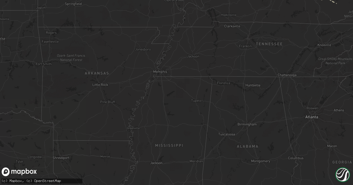
Hail Map in Kansas on March 28, 2012
Get this storm
March 28 map
$229
one time, instant access
Download today. No call, no setup
Keep the $229
Bought the map and want the full workflow? Apply the entire $229 to a subscription within 7 days. None of it is wasted.
Every map, not just this one
This buys you this map. Subscription and you get every map we run, in the markets you choose from a few cities to whole states to nationwide. Plus real-time alerts the moment a storm fires.
Contact data
Name, contact info, occupancy, even credit band for addresses in the footprint. You go from where it hit to who to call.
Become the source they trust
Unlimited branding weather history reports on demand. You already have the documented answer ready for the property owner, and you are the one who showed up with it.
Property data and RoofTrace estimates
Pull up any address you have got, its value and the exact code rules for that jurisdiction, straight from One Click Code. Then RoofTrace estimates the squares, pitch, and roof value, priced the way you price.
Storm reports in Kansas
Kansas
| Date | Description |
|---|---|
| 03/28/20126:57 PM CDT | Delayed report from severe hail verification experiment - shave. |
| 03/28/20126:56 PM CDT | A local report indicates 1.25 inch wind near 1 N CARBONDALE |
| 03/28/20126:55 PM CDT | Delayed report. |
| 03/28/20126:54 PM CDT | A local report indicates 1.75 inch wind near 3 SSW CARBONDALE |
| 03/28/20126:52 PM CDT | A local report indicates 1.00 inch wind near COUNCIL GROVE |
| 03/28/20126:50 PM CDT | Hail estimated at 2 inches based on comparison to hen egg in facebook storm report. |
| 03/28/20126:49 PM CDT | A local report indicates 1.00 inch wind near COUNCIL GROVE |
| 03/28/20126:48 PM CDT | A local report indicates 1.00 inch wind near COUNCIL GROVE |
| 03/28/20126:47 PM CDT | Delayed report from the severe hazards analysis and verification experiment...shave |
| 03/28/20126:45 PM CDT | Hail estimated at 2.5 inches from facebook storm report image. |
| 03/28/20126:36 PM CDT | A local report indicates 1.75 inch wind near 4 SW CARBONDALE |
| 03/28/20126:33 PM CDT | A local report indicates 1.75 inch wind near 4 S CARBONDALE |
| 03/28/20126:33 PM CDT | A local report indicates 1.25 inch wind near 3 SE SCRANTON |
| 03/28/20126:33 PM CDT | Hail covering ground |
| 03/28/20126:28 PM CDT | Numerous 2 to 2.25 inch hail stones reported. |
| 03/28/20126:22 PM CDT | A local report indicates 1.25 inch wind near 3 E BURLINGAME |
| 03/28/20126:20 PM CDT | A local report indicates 2.00 inch wind near 5 SSE SCRANTON |
| 03/28/20126:04 PM CDT | A local report indicates 1.00 inch wind near 2 WNW CARBONDALE |
| 03/28/20125:58 PM CDT | A local report indicates 1.00 inch wind near 2 WNW CARBONDALE |
| 03/28/20125:52 PM CDT | A local report indicates 1.50 inch wind near 6 N BURLINGAME |
| 03/28/20125:47 PM CDT | A local report indicates 2.00 inch wind near 3 NW SCRANTON |
| 03/28/20125:35 PM CDT | A local report indicates 1.00 inch wind near 3 N BURLINGAME |
| 03/28/20125:25 PM CDT | Delayed report from the severe hazards analysis and verification experiment...shave |
| 03/27/201211:36 PM CDT | A local report indicates 1.00 inch wind near SW BERN |
| 03/27/201210:51 PM CDT | A local report indicates 1.00 inch wind near 2 N SENECA |
| 03/27/201210:16 PM CDT | A local report indicates 1.00 inch wind near BAILEYVILLE |
| 03/27/201210:15 PM CDT | Hail fell for over 20 minutes in bern |
| 03/27/201210:03 PM CDT | A local report indicates 1.00 inch wind near 4 SSW BAILEYVILLE |
| 03/27/20129:57 PM CDT | A local report indicates 1.75 inch wind near 5 WNW BERN |
| 03/27/20129:19 PM CDT | A local report indicates 1.00 inch wind near 3 SSE MAYETTA |
| 03/27/20129:15 PM CDT | A plethora of golfball-sized hail occurring 2 miles north of hilltop. |
| 03/27/20129:11 PM CDT | Golfball to tennis ball size hail. |
| 03/27/20129:11 PM CDT | A local report indicates 1.00 inch wind near 2 W HOYT |
| 03/27/20129:10 PM CDT | Delayed report |
| 03/27/20129:08 PM CDT | Delayed report from social media. |
| 03/27/20128:57 PM CDT | A local report indicates 4.25 inch wind near MADISON |
| 03/27/20128:55 PM CDT | A local report indicates 1.00 inch wind near 7 NW READING |
| 03/27/20128:47 PM CDT | A local report indicates 1.00 inch wind near MADISON |
| 03/27/20128:38 PM CDT | A local report indicates 2.00 inch wind near 5 SSE BUSHONG |
| 03/27/20128:33 PM CDT | A local report indicates 1.75 inch wind near 11 N EMPORIA |
| 03/27/20128:26 PM CDT | A local report indicates 1.00 inch wind near 6 S ADMIRE |
| 03/27/20128:25 PM CDT | A local report indicates 1.25 inch wind near 2 E WESTMORELAND |
| 03/27/20128:17 PM CDT | A local report indicates 1.50 inch wind near 4 NNW LOUISVILLE |
| 03/27/20128:07 PM CDT | A local report indicates 1.50 inch wind near 3 NW WAMEGO |
| 03/27/20128:06 PM CDT | A local report indicates 1.50 inch wind near 5 SSE BUSHONG |
| 03/27/20128:00 PM CDT | Also reporting a strongly rotating wall cloud. |
| 03/27/20128:00 PM CDT | Delayed report from social media. |
| 03/27/20127:46 PM CDT | A local report indicates 2.00 inch wind near 5 S BUSHONG |
| 03/27/20127:43 PM CDT | Delayed report from social media. |
| 03/27/20127:15 PM CDT | A local report indicates 1.75 inch wind near DUNLAP |
| 03/27/20127:15 PM CDT | Disk shaped with several golfball-sized. |
| 03/27/20127:11 PM CDT | A local report indicates 1.00 inch wind near 1 SW EMPORIA |
| 03/27/20127:10 PM CDT | Quarter to dime size hail reported. |
| 03/27/20127:10 PM CDT | A local report indicates 1.25 inch wind near DUNLAP |
| 03/27/20127:08 PM CDT | Commerical ave and kansas st. |
| 03/27/20127:06 PM CDT | A local report indicates 1.00 inch wind near CARBONDALE |
| 03/27/20127:05 PM CDT | Lots of golfball hail in town. |
| 03/27/20127:05 PM CDT | A local report indicates 1.25 inch wind near 2 W OVERBROOK |
| 03/27/20127:02 PM CDT | Relayed by wfo topeka. Received on facebook page. |
| 03/27/20127:01 PM CDT | A local report indicates 1.75 inch wind near 5 W OVERBROOK |
| 03/27/20127:00 PM CDT | Delayed report from the severe hazards analysis and verification experiment...shave |
| 03/27/20127:00 PM CDT | A local report indicates 1.50 inch wind near MADISON |
All States Impacted by Hail Map on March 28, 2012
Cities Impacted by Hail Map on March 28, 2012
- Barboursville, WV
- Salt Rock, WV
- Milton, WV
- Versailles, KY
- Chapmanville, WV
- Mayetta, KS
- Hoyt, KS
- Garden City, MO
- Holden, MO
- Blairstown, MO
- Hillsboro, KY
- Rockville, MO
- Butler, MO
- Rich Hill, MO
- Oak Grove, MO
- Lone Jack, MO
- Paris, KY
- Sharpsburg, KY
- Owingsville, KY
- Moorefield, KY
- Carlisle, KY
- Clinton, MO
- Urich, MO
- Chilhowee, MO
- Lehr, ND
- Culloden, WV
- Ironton, OH
- Kitts Hill, OH
- Huntington, WV
- Flatwoods, KY
- Hurricane, WV
- South Point, OH
- Chesapeake, OH
- Ona, WV
- Russell, KY
- South Shore, KY
- Proctorville, OH
- Franklin Furnace, OH
- Worthington, KY
- Greenup, KY
- Ashland, KY
- Council Grove, KS
- Mount Sterling, KY
- Winchester, KY
- Holbrook, NE
- Arapahoe, NE
- Grain Valley, MO
- Buckner, MO
- Virgil, KS
- Du Bois, NE
- Oneida, KS
- Bern, KS
- Seneca, KS
- Greenock, PA
- Jeannette, PA
- Adamsburg, PA
- Rillton, PA
- Irwin, PA
- Clairton, PA
- Mckeesport, PA
- Greensburg, PA
- Elizabeth, PA
- Glassport, PA
- West Mifflin, PA
- Pittsburgh, PA
- Boonville, MO
- Bunceton, MO
- Leon, WV
- Gassaway, WV
- Webster Springs, WV
- Cowen, WV
- Sutton, WV
- Erbacon, WV
- Little Birch, WV
- Diana, WV
- Shelbyville, KY
- Taylorsville, KY
- Mount Eden, KY
- Lawrenceburg, KY
- Waddy, KY
- Missouri City, MO
- Liberty, MO
- Independence, MO
- Excelsior Springs, MO
- Orrick, MO
- Olive Hill, KY
- Beatrice, NE
- Filley, NE
- Encinal, TX
- Frohna, MO
- Altenburg, MO
- Waynesburg, KY
- Louisa, KY
- Fort Gay, WV
- Eskridge, KS
- Wolf Lake, IL
- Georgetown, KY
- Sadieville, KY
- Karnes City, TX
- Kenedy, TX
- Madison, KS
- Gridley, KS
- Hartford, KS
- Hamilton, KS
- Lexington, KY
- Courtland, KS
- Bentleyville, PA
- Eighty Four, PA
- Scenery Hill, PA
- Diller, NE
- Tilden, TX
- Linwood, KS
- Eudora, KS
- Tonganoxie, KS
- Denison, KS
- Meriden, KS
- Mcconnelsville, OH
- Helvetia, WV
- Pickens, WV
- Huttonsville, WV
- Mill Creek, WV
- Calliham, TX
- Beeville, TX
- Cynthiana, KY
- Stamping Ground, KY
- Reading, KS
- Sibley, MO
- New Stanton, PA
- Arona, PA
- South Park, PA
- Bridgeville, PA
- Bethel Park, PA
- Herminie, PA
- Americus, KS
- Wamego, KS
- Saint George, KS
- Olpe, KS
- Emporia, KS
- French Creek, WV
- Mabie, WV
- Freer, TX
- San Diego, TX
- Silver Lake, KS
- Prichard, WV
- Catlettsburg, KY
- Vanceburg, KY
- Rush, KY
- Grayson, KY
- East Lynn, WV
- Branchland, WV
- Wayne, WV
- Emerson, KY
- Floresville, TX
- Sandgap, KY
- Tyner, KY
- McKee, KY
- Alma, KS
- Allen, KS
- Kenova, WV
- Louisville, KY
- Wathena, KS
- Troy, KS
- Carbondale, KS
- Scranton, KS
- Midkiff, WV
- Wallingford, KY
- Flemingsburg, KY
- Tollesboro, KY
- Ranger, WV
- Mayslick, KY
- Maysville, KY
- Harveyville, KS
- Frankfort, KY
- Midway, KY
- Burlingame, KS
- Linn, WV
- Coxs Mills, WV
- Rock Cave, WV
- Weston, WV
- Burnsville, WV
- Ireland, WV
- Walkersville, WV
- Crawford, WV
- Orlando, WV
- Cleveland, WV
- Glenville, WV
- Campbellton, TX
- Falls City, TX
- Three Rivers, TX
- Fisherville, KY
- Cotulla, TX
- Laredo, TX
- Horton, KS
- Blackburn, MO
- Concordia, MO
- Yoakum, TX
- Kenna, WV
- Advent, WV
- Walton, WV
- Gandeeville, WV
- Anna, IL
- Jonesboro, IL
- Cobden, IL
- Weston, MO
- Pedro, OH
- Webbville, KY
- Sandy Hook, KY
- Blackwater, MO
- Pilot Grove, MO
- Ewing, KY
- Morehead, KY
- Wishek, ND
- Burgettstown, PA
- Joffre, PA
- Yorktown, TX
- Hambleton, WV
- Onaga, KS
- Westmoreland, KS
- Runge, TX
- Hobson, TX
- Lathrop, MO
- Cameron, MO
- Stewartsville, MO
- Osborn, MO
- Kingston, MO
- Turney, MO
- Plattsburg, MO
- Polo, MO
- Middle Brook, MO
- Winfield, WV
- Red House, WV
- Eleanor, WV
- Fraziers Bottom, WV
- Buffalo, WV
- Dilley, TX
- Big Wells, TX
- Appleton City, MO
- Claysville, PA
- Washington, PA
- Avella, PA
- Dwight, KS
- Alta Vista, KS
- Oxford, NE
- Fairview, KS
- Corning, OH
- Crooksville, OH
- Alto Pass, IL
- Grand Tower, IL
- Big Springs, WV
- Harrisville, WV
- Smithville, WV
- Paola, KS
- Sweet Springs, MO
- Thomas, WV
- Parsons, WV
- Hendricks, WV
- Montrose, WV
- Thousandsticks, KY
- Baileyville, KS
- Millstone, WV
- Perryville, MO
- Reedy, WV
- Sandyville, WV
- Spencer, WV
- Arnoldsburg, WV
- Le Roy, WV
- Maple Hill, KS
- Topeka, KS
- Upperglade, WV
- Camden On Gauley, WV
- De Kalb, MO
- Rushville, MO
- Mathias, WV
- Moorefield, WV
- Calhoun, MO
- Alice, TX
- Orange Grove, TX
- Perryopolis, PA
- Dawson, PA
- Hollenberg, KS
- Hanover, KS
- Odell, NE
- Centerview, MO
- Kansas City, MO
- Rossville, KS
- Goliad, TX
- Concepcion, TX
- Blue Springs, MO
- Annville, KY
- Ivydale, WV
- Centralia, KS
- Vermillion, KS
- Looneyville, WV
- Willow Wood, OH
- Simpsonville, KY
- Finchville, KY
- Smithville, MO
- Eglon, WV
- Aurora, WV
- Lesage, WV
- Lansing, KS
- Leavenworth, KS
- Proctor, WV
- Robstown, TX
- Cameron, WV
- Bagdad, KY
- Everest, KS
- Ceredo, WV
- Lavalette, WV
- Argillite, KY
- Garrison, KY
- Orma, WV
- Whiting, KS
- Netawaka, KS
- Holton, KS
- Saltsburg, PA
- Apollo, PA
- Export, PA
- Admire, KS
- Flatgap, KY
- Martha, KY
- Blaine, KY
- Keaton, KY
- Stambaugh, KY
- McLouth, KS
- Guysville, OH
- Coolville, OH
- Frametown, WV
- Eureka, SD
- Waverly, MO
- Belvue, KS
- Clendenin, WV
- Elkview, WV
- Ironton, MO
- Pilot Knob, MO
- Holbrook, PA
- Waynesburg, PA
- Rogersville, PA
- Weirton, WV
- Toronto, OH
- Bulger, PA
- New Cumberland, WV
- Imperial, PA
- Darragh, PA
- Nicholasville, KY
- Richmond, KY
- Alum Bridge, WV
- Kanawha Head, WV
- Bartow, WV
- Sand Fork, WV
- Tallmansville, WV
- Macfarlan, WV
- Arcadia, MO
- Belleview, MO
- Sistersville, WV
- Middlebourne, WV
- New Martinsville, WV
- Newton, WV
- Ripley, WV
- Gay, WV
- Left Hand, WV
- Amma, WV
- Saint Joseph, MO
- Rockwood, IL
- Farrar, MO
- Overbrook, KS
- Durbin, WV
- Midway, PA
- McDonald, PA
- Booneville, KY
- Ricetown, KY
- Formoso, KS
- Jewell, KS
- Murrysville, PA
- Monroeville, PA
- Delmont, PA
- Burchard, NE
- Table Rock, NE
- Pawnee City, NE
- Steinauer, NE
- Southside, WV
- Delia, KS
- Auburn, KS
- Sod, WV
- Emlenton, PA
- Morrowville, KS
- Fairbury, NE
- Mahaska, KS
- Oneida, KY
- Axtell, KS
- Shippenville, PA
- Wallback, WV
- Chloe, WV
- Liberty, NE
- Yawkey, WV
- Alum Creek, WV
- Griffithsville, WV
- Sumerco, WV
- Bonne Terre, MO
- Belle Vernon, PA
- West Newton, PA
- Monongahela, PA
- Smithton, PA
- Creekside, PA
- Home, PA
- Given, WV
- Charleston, WV
- Liberty, WV
- Poth, TX
- Thornton, WV
- Blue Grass, VA
- Birchleaf, VA
- Bee, VA
- Fairmont, WV
- Farmington, WV
- Worthington, WV
- Manhattan, KS
- Montrose, MO
- Schell City, MO
- Wetmore, KS
- Bendena, KS
- Rosedale, WV
- Alkol, WV
- Rayville, MO
- Richmond, MO
- Dawson, NE
- Sabetha, KS
- Platte City, MO
- Dearborn, MO
- Humboldt, NE
- Corning, KS
- Littleton, WV
- Ovando, MT
- Bethany, WV
- Henderson, WV
- Clintwood, VA
- Mount Zion, WV
- Grantsville, WV
- Genoa, WV
- Ligonier, PA
- Highland, KS
- Robinson, KS
- Gallipolis Ferry, WV
- Apple Grove, WV
- Norborne, MO
- Villisca, IA
- Waldron, MO
- Malta Bend, MO
- Buena Vista, PA
- Wymore, NE
- West Hamlin, WV
- Grafton, WV
- Irvine, KY
- Knob Noster, MO
- Warrensburg, MO
- Blue Springs, NE
- Mannington, WV
- Moundsville, WV
- Glen Easton, WV
- Seguin, TX
- Easton, KS
- Sardis, OH
- Isonville, KY
- Lowmansville, KY
- Sitka, KY
- New Matamoras, OH
- Woodsfield, OH
- Graysville, OH
- Long Lake, SD
- Manchester, KY
- Jerusalem, OH
- Clarington, OH
- Beallsville, OH
- Jacksonburg, WV
- Reader, WV
- Pine Grove, WV
- Goff, KS
- Evans, WV
- Duck, WV
- Wind Ridge, PA
- Corder, MO
- Wilmore, KY
- Cuero, TX
- Creighton, MO
- Leeton, MO
- Basehor, KS
- Savannah, MO
- Finleyville, PA
- Venetia, PA
- New Eagle, PA
- Bunola, PA
- Sextons Creek, KY
- Nixon, TX
- Hamlin, WV
- Tornado, WV
- Muscotah, KS
- Portland, OH
- Millwood, WV
- Ravenswood, WV
- Cuddy, PA
- Mount Jackson, VA
- Edinburg, VA
- Nordheim, TX
- Palestine, WV
- Elwood, NE
- Elwood, KS
- Coal Center, PA
- Charleroi, PA
- Lewisville, OH
- Racine, OH
- Circleville, WV
- Tunnelton, WV
- Moatsville, WV
- Lincoln, MO
- Windsor, MO


