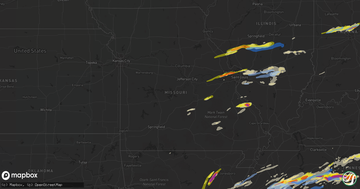
Hail Map in Missouri on March 27, 2021
Get this storm
March 27 map
$229
one time, instant access
Download today. No call, no setup
Keep the $229
Bought the map and want the full workflow? Apply the entire $229 to a subscription within 7 days. None of it is wasted.
Every map, not just this one
This buys you this map. Subscription and you get every map we run, in the markets you choose from a few cities to whole states to nationwide. Plus real-time alerts the moment a storm fires.
Contact data
Name, contact info, occupancy, even credit band for addresses in the footprint. You go from where it hit to who to call.
Become the source they trust
Unlimited branding weather history reports on demand. You already have the documented answer ready for the property owner, and you are the one who showed up with it.
Property data and RoofTrace estimates
Pull up any address you have got, its value and the exact code rules for that jurisdiction, straight from One Click Code. Then RoofTrace estimates the squares, pitch, and roof value, priced the way you price.
Storm reports in Missouri
Missouri
| Date | Description |
|---|---|
| 03/27/20216:45 PM CDT | Siding completely ripped off the west side of a house. Trees downed. |
| 03/27/20215:35 PM CDT | A local report indicates 1.00 inch wind near 1 WNW SPANISH LAKE |
| 03/27/20215:29 PM CDT | Via facebook report with picture. |
| 03/27/20215:27 PM CDT | Corrects previous hail report from hazelwood. |
| 03/27/20215:21 PM CDT | Report from mping: quarter |
| 03/27/20215:17 PM CDT | Report from mping: quarter |
| 03/27/20215:13 PM CDT | Report from mping: quarter |
| 03/27/20215:11 PM CDT | Report from mping: quarter |
| 03/27/20215:09 PM CDT | A local report indicates 1.00 inch wind near 3 SSW WELDON SPRING |
| 03/27/20215:07 PM CDT | Via facebook with measurements. Hail of variable size but 1in max. |
| 03/27/20215:05 PM CDT | 1.75 inch hail at the nws office in weldon spring. |
| 03/27/20212:53 AM CDT | At 753 PM CDT, a severe thunderstorm was located near Reynolds, moving east at 55 mph. HAZARD...60 mph wind gusts and quarter size hail. SOURCE...Radar indicated. IMPACT...Hail damage to vehicles is expected. Expect wind damage to roofs, siding, and trees. Locations impacted include... Fredericktown, Ironton, Reynolds, Ellington, Pilot Knob, Arcadia, Annapolis, Junction City, Cobalt, Marquand, Buckhorn, Glover, Roselle, Garwood, Saco, Centerville, Des Arc, Corridon, Sabula and Mine La Motte.This also includes Fort Davidson Historic Site, Taum Sauk MountainState Park, and Clearwater Lake Recreational Area. |
| 03/27/20211:56 AM CDT | At 655 PM CDT, a severe thunderstorm was located over Maryville, moving east at 45 mph. HAZARD...60 mph wind gusts and quarter size hail. SOURCE...Radar indicated. IMPACT...Hail damage to vehicles is expected. Expect wind damage to roofs, siding, and trees. Locations impacted include... Belleville, Granite City, O'Fallon, East St. Louis, Collinsville, Edwardsville, Fairview Heights, Swansea, Glen Carbon, Shiloh, Wood River, Highland, Troy, Bethalto, Maryville, Greenville, Pontoon Beach, Centreville, Breese and Lebanon.This includes the following highways... Interstate 70 in Illinois between exits 21 and 45. Interstate 55 in Illinois between exits 23 and 30. Interstate 64 in Illinois between exits 9 and 19.This also includes Carlyle Lake Recreational Area and Horseshoe LakeState Park. |
| 03/27/202112:36 AM CDT | At 536 PM CDT, a severe thunderstorm was located near Cuba, moving northeast at 30 mph. HAZARD...60 mph wind gusts and quarter size hail. SOURCE...Radar indicated. IMPACT...Hail damage to vehicles is expected. Expect wind damage to roofs, siding, and trees. Locations impacted include... Sullivan, Cuba, Steelville, Bourbon, Anthonies Mill, Leasburg, Richwoods and St. Cloud.This includes Interstate 44 in Missouri between exits 203 and 218. This also includes Onondaga Cave State Park. |
| 03/27/202112:24 AM CDT | At 523 PM CDT, a severe thunderstorm was located near Bland, moving east at 45 mph. HAZARD...60 mph wind gusts and quarter size hail. SOURCE...Radar indicated. IMPACT...Hail damage to vehicles is expected. Expect wind damage to roofs, siding, and trees. Locations impacted include... Washington, Union, Pacific, St. Clair, Owensville, New Haven, Gray Summit, Villa Ridge, Gerald, Bland, Parkway, Rosebud, Swiss, Mount Sterling, Beaufort, Lonedell, Drake, Leslie, Canaan and Robertsville.This includes Interstate 44 in Missouri between exits 239 and 257. This also includes Robertsville State Park. |
| 03/26/202111:23 PM CDT | At 423 PM CDT, a severe thunderstorm was located near Belleview, moving northeast at 60 mph. HAZARD...60 mph wind gusts and quarter size hail. SOURCE...Radar indicated. IMPACT...Hail damage to vehicles is expected. Expect wind damage to roofs, siding, and trees. Locations impacted include... White Hall, Carrollton, Roodhouse, Belleview, Patterson, Kampsville, Wrights, Eldred, Hillview, Pearl, Hamburg, Paynesville, Annada, Belltown, Mozier, Berdan, Haypress, Barrow, Walkersville and Beecreek. |
| 03/26/202111:16 PM CDT | At 415 PM CDT, a severe thunderstorm was located near Swiss, moving northeast at 50 mph. HAZARD...60 mph wind gusts and quarter size hail. SOURCE...Radar indicated. IMPACT...Hail damage to vehicles is expected. Expect wind damage to roofs, siding, and trees. Locations impacted include... O'Fallon, Wentzville, Lake St. Louis, Washington, Dardenne Prairie, New Haven, Marthasville, Innsbrook, New Melle, Josephville, Swiss, Treloar, Dutzow, Defiance, Flint Hill, Foristell, Lyon and Holstein.This includes Interstate 70 in Missouri between exits 203 and 212. |
| 03/26/20218:15 PM CDT | A local report indicates 1.00 inch wind near 3 SSW RIVER AUX VASES |
| 03/26/20217:46 PM CDT | Tree limbs reported down via public report. |
All States Impacted by Hail Map on March 27, 2021
Cities Impacted by Hail Map on March 27, 2021
- Gate City, VA
- De Berry, TX
- Beckville, TX
- Carthage, TX
- Labadie, MO
- Owens Cross Roads, AL
- Gurley, AL
- Wynne, AR
- Parkin, AR
- Cherry Valley, AR
- Colt, AR
- Jacksonville, AR
- Sherrill, AR
- Brinkley, AR
- Humphrey, AR
- Wabbaseka, AR
- Altheimer, AR
- Holly Grove, AR
- Roe, AR
- England, AR
- Stuttgart, AR
- Clarendon, AR
- Humnoke, AR
- Ashdown, AR
- Texarkana, TX
- New Boston, TX
- Hooks, TX
- Farina, IL
- Louisville, IL
- Xenia, IL
- Cabot, AR
- Austin, AR
- Kenansville, NC
- Warsaw, NC
- Sunbright, TN
- Clarkrange, TN
- Lancing, TN
- Monterey, TN
- Deer Lodge, TN
- Hope Mills, NC
- Fayetteville, NC
- Fouke, AR
- New Hope, AL
- Drummonds, TN
- Raleigh, NC
- Morrisville, NC
- Lonoke, AR
- Scott, AR
- Greeneville, TN
- Afton, TN
- Nashville, TN
- Kingston Springs, TN
- Pegram, TN
- Fairview, TN
- Fulton, MS
- Mantachie, MS
- Reklaw, TX
- Laneville, TX
- Rusk, TX
- Concord, NC
- Caledonia, MS
- Redfield, AR
- Hensley, AR
- Little Rock, AR
- Sheridan, AR
- Crawfordsville, IN
- Keithville, LA
- Keatchie, LA
- Long Branch, TX
- Gary, TX
- Mount Enterprise, TX
- Middletown, MO
- Lebanon, TN
- Mount Juliet, TN
- Statesville, NC
- Ward, AR
- Millport, AL
- Kennedy, AL
- Whitestown, IN
- Carmel, IN
- New Ross, IN
- Zionsville, IN
- Westfield, IN
- Sheridan, IN
- Ladoga, IN
- Jamestown, IN
- Lebanon, IN
- Noblesville, IN
- Advance, IN
- Hamburg, AR
- Laredo, TX
- College Grove, TN
- Eagleville, TN
- Mocksville, NC
- Greensboro, NC
- Lexington, NC
- Cooleemee, NC
- Thomasville, NC
- Snow Camp, NC
- Liberty, NC
- Climax, NC
- High Point, NC
- Julian, NC
- Advance, NC
- Winston Salem, NC
- Cleveland, NC
- Pleasant Garden, NC
- Woodleaf, NC
- Trinity, NC
- Sophia, NC
- Randleman, NC
- Kingsport, TN
- Mount Carmel, TN
- Blountville, TN
- Hiltons, VA
- Bristol, TN
- Bristol, VA
- New Market, IN
- Sanford, NC
- Cameron, NC
- Hope, AR
- Arkadelphia, AR
- Prescott, AR
- Emmet, AR
- Okolona, AR
- Gurdon, AR
- Rockvale, TN
- Johnson City, TN
- Albertville, AL
- Geraldine, AL
- Collinsville, AL
- Fyffe, AL
- Dawson, AL
- Groveoak, AL
- Fort Payne, AL
- Jonesborough, TN
- Telford, TN
- Limestone, TN
- Garland City, AR
- Lewisville, AR
- Texarkana, AR
- Wilson, NC
- Elm City, NC
- Knoxville, TN
- Ethelsville, AL
- Columbus, MS
- Wilder, TN
- Jamestown, TN
- Selmer, TN
- Adamsville, TN
- Bethel Springs, TN
- Morris Chapel, TN
- Alma, IL
- Salem, IL
- Patoka, IL
- Saint Peter, IL
- Odin, IL
- Edgewood, IL
- Kinmundy, IL
- Robbins, TN
- Brooksville, MS
- Rickman, TN
- Livingston, TN
- Cookeville, TN
- Grady, AR
- Dumas, AR
- Gould, AR
- Star City, AR
- Cullman, AL
- Spring Hill, TN
- Casey, IL
- Chuckey, TN
- Watauga, TN
- Elizabethton, TN
- Eva, AL
- Bremen, AL
- Hanceville, AL
- Glen Carbon, IL
- Marine, IL
- Collinsville, IL
- Highland, IL
- Edwardsville, IL
- Saint Jacob, IL
- Maryville, IL
- Troy, IL
- Trilla, IL
- Windsor, IL
- Gays, IL
- Mattoon, IL
- Stewardson, IL
- Neoga, IL
- Franklinville, NC
- Brentwood, TN
- Franklin, TN
- Pikeville, NC
- Charlotte, NC
- Faison, NC
- Clinton, NC
- Carthage, TN
- Riddleton, TN
- North Little Rock, AR
- Hampton, AR
- Greenup, IL
- Martinsville, IL
- Chidester, AR
- Hughes Springs, TX
- Naples, TX
- New Tazewell, TN
- Corryton, TN
- Luttrell, TN
- Lenoir City, TN
- Sherwood, TN
- Stevenson, AL
- Aberdeen, MS
- Rogersville, TN
- Modesto, IL
- Auburn, IL
- Taylorville, IL
- Palmyra, IL
- Owaneco, IL
- Thayer, IL
- Waverly, IL
- Pawnee, IL
- Morrisonville, IL
- Virden, IL
- Palmer, IL
- Farmersville, IL
- Girard, IL
- Marianna, AR
- Maben, MS
- Shreveport, LA
- Pleasant Shade, TN
- Dixon Springs, TN
- Gainesboro, TN
- Whitleyville, TN
- Elmwood, TN
- Granville, TN
- Bon Aqua, TN
- Primm Springs, TN
- Huntersville, NC
- Springville, AL
- Odenville, AL
- Detroit, AL
- Sulligent, AL
- Peel, AR
- Yellville, AR
- Floyd, VA
- Carthage, NC
- Eagle Springs, NC
- Sallisaw, OK
- Huntsville, AL
- Clayton, NC
- Smithfield, NC
- Seymour, TN
- Bybee, TN
- White Pine, TN
- Newport, TN
- Newport, AR
- Cord, AR
- Newark, AR
- Tuckerman, AR
- Wartrace, TN
- Normandy, TN
- Manchester, TN
- Shelbyville, TN
- Griffithville, AR
- Carlisle, AR
- Garner, AR
- Higginson, AR
- McRae, AR
- Kensett, AR
- Searcy, AR
- Beebe, AR
- Judsonia, AR
- Bald Knob, AR
- Steens, MS
- Tyronza, AR
- Crossville, TN
- Henderson, TX
- Shobonier, IL
- Mulberry Grove, IL
- Brownstown, IL
- Vandalia, IL
- White Plains, GA
- Greensboro, GA
- Queen City, TX
- Trenton, AL
- Scottsboro, AL
- Somerville, AL
- Union Grove, AL
- Fackler, AL
- Arab, AL
- Woodville, AL
- Paint Rock, AL
- Joppa, AL
- Hollytree, AL
- Vinemont, AL
- Grant, AL
- Baileyton, AL
- Almyra, AR
- De Witt, AR
- Kannapolis, NC
- Mount Pleasant, NC
- Granite City, IL
- Tichnor, AR
- Gillett, AR
- Dandridge, TN
- Farragut, TN
- Loudon, TN
- Beech Bluff, TN
- Luray, TN
- South Pittsburg, TN
- Trenton, NC
- Pink Hill, NC
- Deep Run, NC
- Tuscumbia, AL
- Russellville, AL
- Snow Lake, AR
- Watson, AR
- Wilmar, AR
- Monticello, AR
- Swifton, AR
- Magnolia, NC
- Rose Hill, NC
- Beulaville, NC
- Decaturville, TN
- Medon, TN
- Lexington, TN
- Jacks Creek, TN
- Reagan, TN
- Jackson, TN
- Huron, TN
- Henderson, TN
- Darden, TN
- Parsons, TN
- Pinson, TN
- Scotts Hill, TN
- Camden, AR
- Hartford, IL
- Roxana, IL
- East Alton, IL
- Saint Louis, MO
- Alhambra, IL
- South Roxana, IL
- Mount Olive, NC
- Banks, AR
- Warren, AR
- Muldrow, OK
- Stilwell, OK
- Tillar, AR
- McGehee, AR
- Fort Bragg, NC
- Sevierville, TN
- Kodak, TN
- Homer, LA
- Sparkman, AR
- Kingsland, AR
- Rison, AR
- Carthage, AR
- Waldo, AR
- Stephens, AR
- McNeil, AR
- Thornton, AR
- New Edinburg, AR
- Magnolia, AR
- Butler, TN
- Mountain City, TN
- Moro, AR
- Forrest City, AR
- Palestine, AR
- Madison, AR
- Dugspur, VA
- Willis, VA
- Nebo, IL
- Eldred, IL
- White Hall, IL
- Eolia, MO
- Elsberry, MO
- Assumption, IL
- Silex, MO
- Greenfield, IL
- Hillview, IL
- Roodhouse, IL
- Stonington, IL
- Moweaqua, IL
- Rockbridge, IL
- Clarksville, MO
- Franklin, IL
- Harvel, IL
- Divernon, IL
- Carrollton, IL
- Kampsville, IL
- Annada, MO
- Hamburg, IL
- Adamsville, AL
- Crossville, AL
- Walnut Hill, IL
- Woodlawn, IL
- Centralia, IL
- Dix, IL
- Steelville, MO
- Cuba, MO
- Oil Trough, AR
- Bradford, AR
- Garland, NC
- Elizabethtown, NC
- Roseboro, NC
- Lexington, KY
- Paris, KY
- Burns, TN
- Lerna, IL
- Toledo, IL
- Rutledge, TN
- Blaine, TN
- Troy, NC
- Albemarle, NC
- New London, NC
- Madison, AL
- Finger, TN
- Williamsport, TN
- Duck River, TN
- Santa Fe, TN
- Readyville, TN
- Christiana, TN
- Murfreesboro, TN
- Hillsville, VA
- Brickeys, AR
- Lobelville, TN
- Garwood, TX
- Hallettsville, TX
- Waveland, IN
- Cicero, IN
- Oak Ridge, TN
- Kingston, TN
- Linden, TN
- Holladay, TN
- Chapel Hill, TN
- Thompsons Station, TN
- Morrison, TN
- Hohenwald, TN
- Mount Pleasant, TN
- Centerville, TN
- Bell Buckle, TN
- Beechgrove, TN
- Denmark, TN
- Arrington, TN
- Mercer, TN
- Mcminnville, TN
- Toone, TN
- Unionville, TN
- Nunnelly, TN
- Hampshire, TN
- Lewisburg, TN
- Sugar Tree, TN
- Columbia, TN
- Bradyville, TN
- Woodbury, TN
- Wildersville, TN
- Ulm, AR
- Galax, VA
- Woodlawn, VA
- West End, NC
- Davidson, NC
- Belleville, IL
- Millstadt, IL
- Newburg, MO
- Edgar Springs, MO
- Duke, MO
- Oneida, TN
- Winfield, TN
- Sandoval, IL
- Iuka, IL
- Denton, NC
- Ramseur, NC
- Siler City, NC
- Bennett, NC
- Seagrove, NC
- Asheboro, NC
- Erwin, NC
- Coats, NC
- Princeton, NC
- Lillington, NC
- Dunn, NC
- Four Oaks, NC
- Benson, NC
- Richview, IL
- Irvington, IL
- Wendell, NC
- Knightdale, NC
- Cordova, AL
- Jasper, AL
- Clinton, TN
- Andersonville, TN
- Norris, TN
- Ellington, MO
- Bowling Green, MO
- Grapevine, AR
- Abingdon, VA
- Haynesville, LA
- Sainte Genevieve, MO
- Fredericktown, MO
- Saint Mary, MO
- Chester, IL
- Farmington, MO
- Perryville, MO
- Lyles, TN
- Jackson Springs, NC
- Ellerbe, NC
- Corinth, MS
- Hughes, AR
- Independence, VA
- Fries, VA
- Star, NC
- Lexa, AR
- McCrory, AR
- Earle, AR
- Cary, NC
- Durham, NC
- Zebulon, NC
- Turkey, NC
- Raeford, NC
- Harrells, NC
- Wallace, NC
- Parkton, NC
- Willard, NC
- Teachey, NC
- Ivanhoe, NC
- Huntsville, TN
- Kell, IL
- Mount Vernon, IL
- Texico, IL
- Pocahontas, IL
- Keyesport, IL
- Greenville, IL
- Smithboro, IL
- Mason, IL
- Carlyle, IL
- Vernon, IL
- Crawford, MS
- Sardis, TN
- Saltillo, TN
- Mouth Of Wilson, VA
- Waynesboro, TN
- Clifton, TN
- Gattman, MS
- Vass, NC
- Spring Lake, NC
- Pope Army Airfield, NC
- West Point, MS
- Midway, TN
- Dyersburg, TN
- Fayette, AL
- Reform, AL
- Powell, TN
- Mathiston, MS
- Eupora, MS
- Mosheim, TN
- Helenwood, TN
- Strunk, KY
- Saint Charles, MO
- O'Fallon, MO
- Marthasville, MO
- Augusta, MO
- Foristell, MO
- Defiance, MO
- Earth City, MO
- Bridgeton, MO
- Maryland Heights, MO
- Saint Peters, MO
- Hillsborough, NC
- Chapel Hill, NC
- Efland, NC
- Cascilla, MS
- Tillatoba, MS
- Charleston, MS
- Casscoe, AR
- Rosston, AR
- Fountain, NC
- Bailey, NC
- Stantonsburg, NC
- Rockford, TN
- Bossier City, LA
- Barksdale Afb, LA
- Haughton, LA
- Parrish, AL
- Duff, TN
- Bunnlevel, NC
- Linden, NC
- Pioneer, TN
- La Follette, TN
- Cushing, TX
- Goldsboro, NC
- Wentzville, MO
- Mooresburg, TN
- Bulls Gap, TN
- Whitesburg, TN
- Springfield, TN
- Speedwell, TN
- Tazewell, TN
- Newton Grove, NC
- Calypso, NC
- Bismarck, MO
- Brownsboro, AL
- Spruce Pine, AL
- Pall Mall, TN
- Alpine, TN
- Angier, NC
- Robbins, NC
- Candor, NC
- Biscoe, NC
- Aubrey, AR
- Joiner, AR
- Belleview, MO
- Ironton, MO
- Thorn Hill, TN
- Leasburg, MO
- Saint James, MO
- Bloomsdale, MO
- Prairie Du Rocher, IL
- La Grange, NC
- Little Rock Air Force Base, AR
- Frakes, KY
- Benoit, MS
- Gilmer, TX
- Diana, TX
- Freeburg, IL
- Mascoutah, IL
- Columbia, IL
- Dudley, NC
- Bartelso, IL
- Okawville, IL
- Hoyleton, IL
- Kinston, NC
- Seven Springs, NC
- Gardendale, AL
- Birmingham, AL
- Pinson, AL
- Morris, AL
- Pleasant Plains, AR
- Thida, AR
- Pine Bluff, AR
- Waynesville, MO
- Fort Leonard Wood, MO
- Ogden, AR
- Maynardville, TN
- Sparta, TN
- Harrogate, TN
- Hendersonville, TN
- De Valls Bluff, AR
- Ozan, AR
- Blevins, AR
- Washington, AR
- Dickson, TN
- Apex, NC
- Elk Creek, VA
- Lansing, NC
- Milan, TN
- Medina, TN
- Lavinia, TN
- Autryville, NC
- Biscoe, AR
- Hazen, AR
- Des Arc, AR
- Greenwood Springs, MS
- Redford, MO
- Graysville, AL
- Brookside, AL
- Mount Olive, AL
- Stamps, AR
- Buckner, AR
- Brownsville, TN
- Whiteville, TN
- Waverly, TN
- Enville, TN
- Somerville, TN
- Gordonsville, TN
- Hilham, TN
- Allardt, TN
- Antioch, TN
- Old Hickory, TN
- Bath Springs, TN
- Only, TN
- Bloomington Springs, TN
- Brush Creek, TN
- Watertown, TN
- Celina, TN
- Hermitage, TN
- Rugby, TN
- Hartsville, TN
- Bluff City, TN
- Piney Flats, TN
- Tatum, TX
- Troup, TX
- Arp, TX
- Tyler, TX
- Jacksonville, TX
- Arlington, TN
- Eads, TN
- Cordova, TN
- Lascassas, TN
- Church Hill, TN
- Thorntown, IN
- Anderson, IN
- Arcadia, IN
- Selma, NC
- Kenly, NC
- Cedarbluff, MS
- Prairie, MS
- Hamilton, MS
- Troutdale, VA
- Whitetop, VA
- Grassy Creek, NC
- Creston, NC
- Elaine, AR
- Louann, AR
- Fordyce, AR
- Amory, MS
- Winona, MO
- Dyer, TN
- Newbern, TN
- Eatonton, GA
- Morristown, TN
- Rosedale, MS
- Beaverton, AL
- Daingerfield, TX
- Marietta, TX
- Burgaw, NC
- Maple Hill, NC
- Surgoinsville, TN
- Halls, TN
- Bells, TN
- Stanton, TN
- Tuscola, IL
- Arcola, IL
- New Market, TN
- Russellville, TN
- Clarksdale, MS
- Ethel, AR
- Farmville, NC
- Walstonburg, NC
- Macclesfield, NC
- Bassett, AR
- Frenchmans Bayou, AR
- Rohwer, AR
- Beulah, MS
- Cedar Grove, TN
- Cumberland Gap, TN
- Mebane, NC
- Graham, NC
- Burlington, NC
- Haw River, NC
- Robinsonville, MS
- Smyrna, TN
- Nolensville, TN
- Willow Spring, NC
- Garner, NC
- Florissant, MO
- Wood River, IL
- Weber City, VA
- Hickory Flat, MS
- Myrtle, MS
- Stanfield, NC
- Bullard, TX
- Lillie, LA
- Spencer, TN
- Pinehurst, NC
- Aberdeen, NC
- Mellwood, AR
- White Hall, AR
- Tucker, AR
- Marvell, AR
- Nashville, NC
- Rocky Mount, NC
- Wharton, TX
- Troy, MO
- Madison, TN
- Bolivar, TN
- Bethany, LA
- Middlesex, NC
- Evansville, IL
- Modoc, IL
- Talbott, TN
- Jefferson City, TN
- Moulton, AL
- Indianapolis, IN
- La Vergne, TN
- Glasgow, KY
- Ferrum, VA
- Spring Hope, NC
- Sims, NC
- Mount Gilead, NC
- Broadway, NC
- Gadsden, TN
- Humboldt, TN
- Dyess, AR
- Wilson, AR
- Gilmore, AR
- Henning, TN
- Burlison, TN
- Marked Tree, AR
- Cotton Plant, AR
- Turrell, AR
- Brighton, TN
- Washington, IN
- Plainville, IN
- Wheatland, IN
- Chinquapin, NC
- Heiskell, TN
- Pinebluff, NC
- Godwin, NC
- Ripley, TN
- Ivan, AR
- Salemburg, NC
- Osceola, AR
- Bessemer, AL
- Mulga, AL
- Quinton, AL
- Licking, MO
- Plato, MO
- Oxford, MS
- Potts Camp, MS
- Jellico, TN
- Williamsburg, KY
- Newcomb, TN
- Bradford, TN
- Trenton, TN
- Friendship, TN
- Pine Knot, KY
- Caryville, TN
- Sewanee, TN
- Fall Branch, TN
- Mendota, VA
- Meadowview, VA
- Lynnville, TN
- Ethridge, TN
- Summertown, TN
- Lawrenceburg, TN
- Holly Springs, MS
- Middleton, TN
- Michigan City, MS
- Walnut, MS
- Saulsbury, TN
- Moscow, TN
- La Grange, TN
- Rossville, TN
- Ashland, MS
- Stantonville, TN
- Shiloh, TN
- Grand Junction, TN
- Michie, TN
- Savannah, TN
- Hickory Valley, TN
- Hornsby, TN
- Byhalia, MS
- Milledgeville, TN
- Ramer, TN
- Oakland, TN
- Crump, TN
- Guys, TN
- Red Banks, MS
- Lamar, MS
- Pocahontas, TN
- Williston, TN
- Alto, TX
- Timpson, TX
- Garrison, TX
- Frierson, LA
- Stonewall, LA
- New Haven, MO
- Hazelwood, MO
- Washington, MO
- Hermann, MO
- Owensville, MO
- Gerald, MO
- Bourbon, MO
- Murrayville, IL
- Pearl, IL
- Frankton, IN
- Marshall, IN
- Bloomingdale, IN
- Cincinnati, OH
- Trussville, AL
- Jamestown, NC
- Richfield, NC
- Alicia, AR
- Walnut Ridge, AR
- Cash, AR
- Saint Charles, AR
- Como, MS
- Coahoma, MS
- Sardis, MS
- Helena, AR
- Senatobia, MS
- Marks, MS
- Crenshaw, MS
- Sledge, MS
- Tunica, MS
- Sarah, MS
- Friars Point, MS
- Lyon, MS
- Dundee, MS
- Coldwater, MS
- Yorktown, AR
- Harrell, AR
- Merigold, MS
- Batesville, MS
- Parchman, MS
- Sumner, MS
- Enid, MS
- Pope, MS
- Oakland, MS
- Gunnison, MS
- Cleveland, MS
- Tutwiler, MS
- Drew, MS
- Shelby, MS
- Mound Bayou, MS
- Lambert, MS
- Vance, MS
- Arkansas City, AR
- Brilliant, AL
- Winfield, AL
- Lynn, AL
- Nauvoo, AL
- Carbon Hill, AL
- Eldridge, AL
- Guin, AL
- Rocky Mount, VA
- Check, VA
- Radford, VA
- Riner, VA
- Callaway, VA
- Copper Hill, VA
- Pilot, VA
- Bethany, IL
- Sullivan, IL
- Waggoner, IL
- Pana, IL
- Findlay, IL
- Shelbyville, IL
- Breese, IL
- Trenton, IL
- Aviston, IL
- Decatur, AL
- Danville, AL


