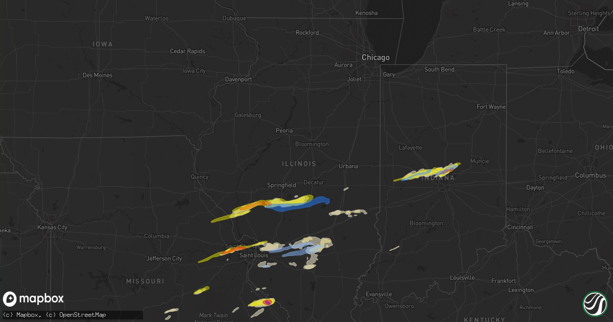
Hail Map in Illinois on March 27, 2021
Get this storm
March 27 map
$229
one time, instant access
Download today. No call, no setup
Keep the $229
Bought the map and want the full workflow? Apply the entire $229 to a subscription within 7 days. None of it is wasted.
Every map, not just this one
This buys you this map. Subscription and you get every map we run, in the markets you choose from a few cities to whole states to nationwide. Plus real-time alerts the moment a storm fires.
Contact data
Name, contact info, occupancy, even credit band for addresses in the footprint. You go from where it hit to who to call.
Become the source they trust
Unlimited branding weather history reports on demand. You already have the documented answer ready for the property owner, and you are the one who showed up with it.
Property data and RoofTrace estimates
Pull up any address you have got, its value and the exact code rules for that jurisdiction, straight from One Click Code. Then RoofTrace estimates the squares, pitch, and roof value, priced the way you price.
Storm reports in Illinois
Illinois
| Date | Description |
|---|---|
| 03/27/20216:55 PM CDT | A local report indicates 1.00 inch wind near COLLINSVILLE |
| 03/27/20216:55 PM CDT | Trees downed on houses. |
| 03/27/20216:00 PM CDT | Large tree down. |
| 03/27/20216:00 PM CDT | Sheet metal on the road and damage to trees. |
| 03/27/20216:00 PM CDT | Video & photos of of trees & power lines down. Small piece of sheet metal also reported wrapped around small tree branch. |
| 03/27/20215:58 PM CDT | Report from mping: quarter |
| 03/27/20215:56 PM CDT | Awos station ktaz taylorville muni ap. |
| 03/27/20215:54 PM CDT | A local report indicates 1.25 inch wind near 1 ENE TAYLORVILLE |
| 03/27/20215:54 PM CDT | Report from mping: half dollar |
| 03/27/20215:33 PM CDT | Estimated 65-70 mph. Relayed via social media. |
| 03/27/20215:33 PM CDT | Relayed via social media. |
| 03/27/20215:30 PM CDT | Corrects previous hail report from virden. Via broadcast media on twitter. |
| 03/27/20214:27 AM CDT | At 927 PM CDT, severe thunderstorms were located along a line extending from Oliver to near West Union, moving east at 30 mph. HAZARD...60 mph wind gusts. SOURCE...Radar indicated. IMPACT...Expect damage to roofs, siding, and trees. Locations impacted include... Marshall, Dennison, West Union, Oliver, York, Darwin, Lincoln Trail State Park and Sandford.This includes Interstate 70 between mile markers 143 and 154. |
| 03/27/20214:11 AM CDT | At 911 PM CDT, a severe thunderstorm was located near Helm, or 11 miles southwest of Flora, moving east at 30 mph. HAZARD...60 mph wind gusts and quarter size hail. SOURCE...Radar indicated. IMPACT...Hail damage to vehicles is expected. Expect wind damage to roofs, siding, and trees. Locations impacted include... Cisne, Jeffersonville, Mount Erie and Johnsonville. |
| 03/27/20213:43 AM CDT | At 843 PM CDT, severe thunderstorms were located along a line extending from 8 miles east of Womac to near Cobalt, moving east at 20 mph. HAZARD...60 mph wind gusts and quarter size hail. SOURCE...Radar indicated. IMPACT...Hail damage to vehicles is expected. Expect wind damage to roofs, siding, and trees. Locations impacted include... Perryville, Alliance, Patton, Sedgewickville, Longtown and Silver Lake.This includes Interstate 55 between Mile Markers 120 and 132. |
| 03/27/20213:22 AM CDT | At 821 PM CDT, a severe thunderstorm was located near Coffman, or 10 miles south of Ste. Genevieve, moving east at 30 mph. HAZARD...60 mph wind gusts and half dollar size hail. SOURCE...Radar indicated. IMPACT...Hail damage to vehicles is expected. Expect wind damage to roofs, siding, and trees. Locations impacted include... Perryville, St. Mary and Lithium. This includes Interstate 55 between Mile Markers 132 and 139. |
| 03/27/20213:21 AM CDT | At 818 PM CDT, severe thunderstorms were located along a line extending from near Altamont to 6 miles southwest of Kinmundy to near Ashley, moving east at 50 mph. HAZARD...60 mph wind gusts. SOURCE...Radar indicated. IMPACT...Expect damage to roofs, siding, and trees. Locations impacted include... Centralia, Salem, Nashville, St. Elmo, Sandoval, Wamac, Central City, Odin, Kinmundy, Brownstown, Irvington, Patoka, Farina, Omega, Stephen Forbes Station, Shobonier, Fairman, Wrights Corner, Shattuc and Helm.This includes the following highways... Interstate 70 in Illinois between exits 68 and 76. Interstate 57 in Illinois between exits 109 and 135. Interstate 64 in Illinois between exits 50 and 61. |
| 03/27/20213:20 AM CDT | At 820 PM CDT, severe thunderstorms were located along a line extending from near Shumway to near Altamont to near Salem, moving east at 45 mph. HAZARD...60 mph wind gusts and nickel size hail. SOURCE...Radar indicated. IMPACT...Expect damage to roofs, siding, and trees. Locations impacted include... Effingham, Flora, Altamont, Teutopolis, Louisville, Clay City, Watson, Dieterich, Beecher City, Edgewood, Xenia, Bible Grove, Shumway, Montrose, Wheeler, Iola, Hidalgo, Sailor Springs, Ingraham and Bogota.This includes the following highways... Interstate 57 between mile markers 143 and 167. Interstate 70 between mile markers 79 and 104. |
| 03/27/20213:11 AM CDT | At 811 PM CDT, severe thunderstorms were located along a line extending from near Lively Grove to near Knob Lick, moving east at 35 mph. HAZARD...60 mph wind gusts and quarter size hail. SOURCE...Radar indicated. IMPACT...Hail damage to vehicles is expected. Expect wind damage to roofs, siding, and trees. Locations impacted include... Farmington, Chester, Ste. Genevieve, Sparta, Nashville, Bremen, Steeleville, Marissa, Percy, Coulterville, Tilden, Evansville, Lively Grove, Ashley, Baldwin, St. Mary, Knob Lick, Weingarten, Womac and Rocky Ridge.This includes Interstate 55 in Missouri between exits 141 and 150. This also includes Hawn State Park and Felix Valle House State Park. |
| 03/27/20213:06 AM CDT | At 806 PM CDT, a severe thunderstorm was located over Stewardson, or 9 miles north of Effingham, moving east at 45 mph. HAZARD...60 mph wind gusts and nickel size hail. SOURCE...Radar indicated. IMPACT...Expect damage to roofs, siding, and trees. Locations impacted include... Charleston, Mattoon, Toledo, Casey, Neoga, Greenup, Ashmore, Stewardson, Lerna, Janesville, Paradise, Hutton, Strasburg, Sigel, Trowbridge, Etna, Fox Ridge State Park, Union Center, Coles County Airport and Trilla.This includes the following highways... Interstate 57 between mile markers 168 and 189. Interstate 70 between mile markers 112 and 126. |
| 03/27/20212:43 AM CDT | At 742 PM CDT, severe thunderstorms were located along a line extending from Van Burensburg to near Beaver Creek to near Lively Grove, moving east at 40 mph. HAZARD...60 mph wind gusts and quarter size hail. SOURCE...Public. Numerous trees and powerlines were reported snapped in St. Jacobs and south of Pocahontas. IMPACT...Hail damage to vehicles is expected. Expect wind damage to roofs, siding, and trees. Locations impacted include... Centralia, Highland, Mascoutah, Vandalia, Greenville, Breese, Lebanon, Freeburg, New Baden, Carlyle, Nashville, Scott AFB, Trenton, New Athens, Aviston, Okawville, St. Elmo, St. Rose, Sandoval and Germantown.This includes the following highways... Interstate 70 in Illinois between exits 30 and 76. Interstate 64 in Illinois between exits 23 and 61.This also includes Carlyle Lake Recreational Area. |
| 03/27/20212:27 AM CDT | At 727 PM CDT, severe thunderstorms were located along a line extending from near Smithton to near Pilot Knob, moving east at 35 mph. HAZARD...60 mph wind gusts and quarter size hail. SOURCE...Radar indicated. IMPACT...Hail damage to vehicles is expected. Expect wind damage to roofs, siding, and trees. Locations impacted include... Farmington, Desloge, Ste. Genevieve, Sparta, Red Bud, Bismarck, Park Hills, New Athens, Marissa, Tilden, Iron Mountain Lake, Evansville, Lively Grove, Bloomsdale, Baldwin, St. Mary, Weingarten, Womac, Rocky Ridge and Knob Lick.This includes Interstate 55 in Missouri between exits 141 and 162. This also includes St. Joe State Park, Hawn State Park, Felix ValleHouse State Park, and Missouri Mines Historic Site. |
| 03/27/20212:06 AM CDT | At 706 PM CDT, a severe thunderstorm was located over Millstadt, moving east at 45 mph. HAZARD...60 mph wind gusts and quarter size hail. SOURCE...Radar indicated. IMPACT...Hail damage to vehicles is expected. Expect wind damage to roofs, siding, and trees. Locations impacted include... Belleville, O'Fallon, Fairview Heights, Cahokia, Swansea, Shiloh, Waterloo, Columbia, Mascoutah, Centreville, Breese, Lebanon, Freeburg, Dupo, Millstadt, New Baden, Carlyle, Nashville, Scott AFB and Smithton.This includes Interstate 64 in Illinois between exits 19 and 50. |
| 03/27/20211:07 AM CDT | At 607 PM CDT, a severe thunderstorm was located over Assumption, or 9 miles east of Taylorville, moving east at 45 mph. HAZARD...60 mph wind gusts and quarter size hail. SOURCE...Radar indicated. IMPACT...Hail damage to vehicles is expected. Expect wind damage to roofs, siding, and trees. Locations impacted include... Shelbyville, Sullivan, Arthur, Moweaqua, Bethany, Macon, Lovington, Windsor, Findlay, Dalton City, Allenville, Westervelt, Gays, Wolf Creek State Park, Lake City, Cadwell, Eagle Creek State Park and Kirksville. |
| 03/27/202112:32 AM CDT | At 532 PM CDT, a severe thunderstorm was located over White Oak, or 9 miles east of Virden, moving east at 55 mph. HAZARD...60 mph wind gusts and quarter size hail. SOURCE...Radar indicated. IMPACT...Hail damage to vehicles is expected. Expect wind damage to roofs, siding, and trees. Locations impacted include... Taylorville, Moweaqua, Kincaid, Assumption, Edinburg, Morrisonville, Stonington, Bulpitt, Jeisyville, Tovey, Owaneco, Palmer, Sangchris Lake State Park, Willeys, Sharpsburg, Sicily and Taylorville Airport. |
| 03/27/202112:26 AM CDT | At 526 PM CDT, a severe thunderstorm was located over Lambert-St. Louis International Airport, moving east at 45 mph. HAZARD...Golf ball size hail and 60 mph wind gusts. SOURCE...Trained weather spotters. IMPACT...People and animals outdoors will be injured. Expect hail damage to roofs, siding, windows, and vehicles. Expect wind damage to roofs, siding, and trees. Locations impacted include... St. Louis, St. Charles, Florissant, University City, Granite City, Alton, Maryland Heights, Hazelwood, Collinsville, Edwardsville, Ferguson, Creve Coeur, Overland, Jennings, St. Ann, Glen Carbon, Bridgeton, Bellefontaine Neighbors, Wood River and Troy.This includes the following highways... Interstate 55 in Illinois near exit 23. Interstate 70 in Missouri near exit 231.This also includes Confluence State Park, First Missouri StateCapitol Historic Site, and Horseshoe Lake State Park. |
| 03/27/202112:18 AM CDT | At 518 PM CDT, a severe thunderstorm was located near Girard, moving east at 50 mph. HAZARD...60 mph wind gusts and quarter size hail. SOURCE...Radar indicated. IMPACT...Hail damage to vehicles is expected. Expect wind damage to roofs, siding, and trees. Locations impacted include... Virden, Girard, White Oak, Farmersville, Palmyra, Nilwood and Modesto. |
| 03/26/202111:54 PM CDT | At 453 PM CDT, a severe thunderstorm was located over Athensville, or 9 miles east of White Hall, moving northeast at 55 mph. HAZARD...60 mph wind gusts and quarter size hail. SOURCE...Radar indicated. IMPACT...Hail damage to vehicles is expected. Expect wind damage to roofs, siding, and trees. Locations impacted include... Springfield, Chatham, Auburn, Rochester, Pawnee, Waverly, Divernon, Loami, Franklin, Thayer, Berry, Glenarm, Nortonville and Lowder.This includes Interstate 55 between mile markers 77 and 91. |
| 03/26/202111:52 PM CDT | At 451 PM CDT, a severe thunderstorm was located over New Melle, moving east at 50 mph. HAZARD...60 mph wind gusts and quarter size hail. SOURCE...Radar indicated. IMPACT...Hail damage to vehicles is expected. Expect wind damage to roofs, siding, and trees. Locations impacted include... O'Fallon, St. Charles, St. Peters, Florissant, Chesterfield, Wildwood, Granite City, Wentzville, Alton, Maryland Heights, Hazelwood, Ferguson, Godfrey, Creve Coeur, Overland, Jennings, Lake St. Louis, St. Ann, Bridgeton and Dardenne Prairie.This includes Interstate 70 in Missouri between exits 214 and 231. This also includes Babler Memorial State Park and First MissouriState Capitol Historic Site. |
| 03/26/202111:47 PM CDT | At 447 PM CDT, a severe thunderstorm was located near White Hall, moving east at 60 mph. HAZARD...60 mph wind gusts and quarter size hail. SOURCE...Radar indicated. IMPACT...Hail damage to vehicles is expected. Expect wind damage to roofs, siding, and trees. Locations impacted include... Virden, White Hall, Carrollton, Girard, Roodhouse, Greenfield, Palmyra, Athensville, Patterson, Wrights, Eldred, Hillview, Modesto, Scottville, Belltown, Berdan, Haypress, Barrow and Walkersville. |
| 03/26/20219:00 PM CDT | Semi-truck blown over on i-70 mile marker 150. No injuries reported. |
| 03/26/20219:00 PM CDT | Semi-truck blown over on i-70 mile marker 141. No injuries reported. |
| 03/26/20218:30 PM CDT | Delayed report. 18 miles sw of mattoon at lake mattoon. |
| 03/26/20218:15 PM CDT | Tree limbs down. |
| 03/26/20217:54 PM CDT | Downed tree branches and other debris... Reported via twitter. |
| 03/26/20217:37 PM CDT | Trees and power lines down along millersburg road. |
| 03/26/20217:18 PM CDT | Flag pole snapped in half. |
| 03/26/20217:17 PM CDT | Report from mping: trees uprooted or snapped; roof blown off. |
| 03/26/20217:17 PM CDT | A local report indicates 62 MPH wind near 1 ENE HIGHLAND |
| 03/26/20217:15 PM CDT | Heavy damage to several buildings... Multiple trees uprooted. |
| 03/26/20217:08 PM CDT | Fence damage with outbuilding destroyed. |
| 03/26/20217:08 PM CDT | Nws official storm survey found an ef-1 tornado occurred along an intermittent path of nearly 5 miles from north of st. Jacob east into highland. The most significant d |
| 03/26/20217:05 PM CDT | Drywall ripped from a home... Roof ripped all off a pole barn. |
| 03/26/20217:03 PM CDT | Fence and deck damage to a home. |
| 03/26/20217:01 PM CDT | *** 1 inj *** a delivery truck was blown into another car on the other side of the road causing a collision. The delivery truck driver was taken to the hospital for min |
| 03/26/20217:00 PM CDT | Small piece of siding ripped from home... Fence blown down. |
| 03/26/20217:00 PM CDT | Large trees down and utilities damaged. |
| 03/26/20217:00 PM CDT | A local report indicates 1.00 inch wind near MARYVILLE |
All States Impacted by Hail Map on March 27, 2021
Cities Impacted by Hail Map on March 27, 2021
- Gate City, VA
- De Berry, TX
- Beckville, TX
- Carthage, TX
- Labadie, MO
- Owens Cross Roads, AL
- Gurley, AL
- Wynne, AR
- Parkin, AR
- Cherry Valley, AR
- Colt, AR
- Jacksonville, AR
- Sherrill, AR
- Brinkley, AR
- Humphrey, AR
- Wabbaseka, AR
- Altheimer, AR
- Holly Grove, AR
- Roe, AR
- England, AR
- Stuttgart, AR
- Clarendon, AR
- Humnoke, AR
- Ashdown, AR
- Texarkana, TX
- New Boston, TX
- Hooks, TX
- Farina, IL
- Louisville, IL
- Xenia, IL
- Cabot, AR
- Austin, AR
- Kenansville, NC
- Warsaw, NC
- Sunbright, TN
- Clarkrange, TN
- Lancing, TN
- Monterey, TN
- Deer Lodge, TN
- Hope Mills, NC
- Fayetteville, NC
- Fouke, AR
- New Hope, AL
- Drummonds, TN
- Raleigh, NC
- Morrisville, NC
- Lonoke, AR
- Scott, AR
- Greeneville, TN
- Afton, TN
- Nashville, TN
- Kingston Springs, TN
- Pegram, TN
- Fairview, TN
- Fulton, MS
- Mantachie, MS
- Reklaw, TX
- Laneville, TX
- Rusk, TX
- Concord, NC
- Caledonia, MS
- Redfield, AR
- Hensley, AR
- Little Rock, AR
- Sheridan, AR
- Crawfordsville, IN
- Keithville, LA
- Keatchie, LA
- Long Branch, TX
- Gary, TX
- Mount Enterprise, TX
- Middletown, MO
- Lebanon, TN
- Mount Juliet, TN
- Statesville, NC
- Ward, AR
- Millport, AL
- Kennedy, AL
- Whitestown, IN
- Carmel, IN
- New Ross, IN
- Zionsville, IN
- Westfield, IN
- Sheridan, IN
- Ladoga, IN
- Jamestown, IN
- Lebanon, IN
- Noblesville, IN
- Advance, IN
- Hamburg, AR
- Laredo, TX
- College Grove, TN
- Eagleville, TN
- Mocksville, NC
- Greensboro, NC
- Lexington, NC
- Cooleemee, NC
- Thomasville, NC
- Snow Camp, NC
- Liberty, NC
- Climax, NC
- High Point, NC
- Julian, NC
- Advance, NC
- Winston Salem, NC
- Cleveland, NC
- Pleasant Garden, NC
- Woodleaf, NC
- Trinity, NC
- Sophia, NC
- Randleman, NC
- Kingsport, TN
- Mount Carmel, TN
- Blountville, TN
- Hiltons, VA
- Bristol, TN
- Bristol, VA
- New Market, IN
- Sanford, NC
- Cameron, NC
- Hope, AR
- Arkadelphia, AR
- Prescott, AR
- Emmet, AR
- Okolona, AR
- Gurdon, AR
- Rockvale, TN
- Johnson City, TN
- Albertville, AL
- Geraldine, AL
- Collinsville, AL
- Fyffe, AL
- Dawson, AL
- Groveoak, AL
- Fort Payne, AL
- Jonesborough, TN
- Telford, TN
- Limestone, TN
- Garland City, AR
- Lewisville, AR
- Texarkana, AR
- Wilson, NC
- Elm City, NC
- Knoxville, TN
- Ethelsville, AL
- Columbus, MS
- Wilder, TN
- Jamestown, TN
- Selmer, TN
- Adamsville, TN
- Bethel Springs, TN
- Morris Chapel, TN
- Alma, IL
- Salem, IL
- Patoka, IL
- Saint Peter, IL
- Odin, IL
- Edgewood, IL
- Kinmundy, IL
- Robbins, TN
- Brooksville, MS
- Rickman, TN
- Livingston, TN
- Cookeville, TN
- Grady, AR
- Dumas, AR
- Gould, AR
- Star City, AR
- Cullman, AL
- Spring Hill, TN
- Casey, IL
- Chuckey, TN
- Watauga, TN
- Elizabethton, TN
- Eva, AL
- Bremen, AL
- Hanceville, AL
- Glen Carbon, IL
- Marine, IL
- Collinsville, IL
- Highland, IL
- Edwardsville, IL
- Saint Jacob, IL
- Maryville, IL
- Troy, IL
- Trilla, IL
- Windsor, IL
- Gays, IL
- Mattoon, IL
- Stewardson, IL
- Neoga, IL
- Franklinville, NC
- Brentwood, TN
- Franklin, TN
- Pikeville, NC
- Charlotte, NC
- Faison, NC
- Clinton, NC
- Carthage, TN
- Riddleton, TN
- North Little Rock, AR
- Hampton, AR
- Greenup, IL
- Martinsville, IL
- Chidester, AR
- Hughes Springs, TX
- Naples, TX
- New Tazewell, TN
- Corryton, TN
- Luttrell, TN
- Lenoir City, TN
- Sherwood, TN
- Stevenson, AL
- Aberdeen, MS
- Rogersville, TN
- Modesto, IL
- Auburn, IL
- Taylorville, IL
- Palmyra, IL
- Owaneco, IL
- Thayer, IL
- Waverly, IL
- Pawnee, IL
- Morrisonville, IL
- Virden, IL
- Palmer, IL
- Farmersville, IL
- Girard, IL
- Marianna, AR
- Maben, MS
- Shreveport, LA
- Pleasant Shade, TN
- Dixon Springs, TN
- Gainesboro, TN
- Whitleyville, TN
- Elmwood, TN
- Granville, TN
- Bon Aqua, TN
- Primm Springs, TN
- Huntersville, NC
- Springville, AL
- Odenville, AL
- Detroit, AL
- Sulligent, AL
- Peel, AR
- Yellville, AR
- Floyd, VA
- Carthage, NC
- Eagle Springs, NC
- Sallisaw, OK
- Huntsville, AL
- Clayton, NC
- Smithfield, NC
- Seymour, TN
- Bybee, TN
- White Pine, TN
- Newport, TN
- Newport, AR
- Cord, AR
- Newark, AR
- Tuckerman, AR
- Wartrace, TN
- Normandy, TN
- Manchester, TN
- Shelbyville, TN
- Griffithville, AR
- Carlisle, AR
- Garner, AR
- Higginson, AR
- McRae, AR
- Kensett, AR
- Searcy, AR
- Beebe, AR
- Judsonia, AR
- Bald Knob, AR
- Steens, MS
- Tyronza, AR
- Crossville, TN
- Henderson, TX
- Shobonier, IL
- Mulberry Grove, IL
- Brownstown, IL
- Vandalia, IL
- White Plains, GA
- Greensboro, GA
- Queen City, TX
- Trenton, AL
- Scottsboro, AL
- Somerville, AL
- Union Grove, AL
- Fackler, AL
- Arab, AL
- Woodville, AL
- Paint Rock, AL
- Joppa, AL
- Hollytree, AL
- Vinemont, AL
- Grant, AL
- Baileyton, AL
- Almyra, AR
- De Witt, AR
- Kannapolis, NC
- Mount Pleasant, NC
- Granite City, IL
- Tichnor, AR
- Gillett, AR
- Dandridge, TN
- Farragut, TN
- Loudon, TN
- Beech Bluff, TN
- Luray, TN
- South Pittsburg, TN
- Trenton, NC
- Pink Hill, NC
- Deep Run, NC
- Tuscumbia, AL
- Russellville, AL
- Snow Lake, AR
- Watson, AR
- Wilmar, AR
- Monticello, AR
- Swifton, AR
- Magnolia, NC
- Rose Hill, NC
- Beulaville, NC
- Decaturville, TN
- Medon, TN
- Lexington, TN
- Jacks Creek, TN
- Reagan, TN
- Jackson, TN
- Huron, TN
- Henderson, TN
- Darden, TN
- Parsons, TN
- Pinson, TN
- Scotts Hill, TN
- Camden, AR
- Hartford, IL
- Roxana, IL
- East Alton, IL
- Saint Louis, MO
- Alhambra, IL
- South Roxana, IL
- Mount Olive, NC
- Banks, AR
- Warren, AR
- Muldrow, OK
- Stilwell, OK
- Tillar, AR
- McGehee, AR
- Fort Bragg, NC
- Sevierville, TN
- Kodak, TN
- Homer, LA
- Sparkman, AR
- Kingsland, AR
- Rison, AR
- Carthage, AR
- Waldo, AR
- Stephens, AR
- McNeil, AR
- Thornton, AR
- New Edinburg, AR
- Magnolia, AR
- Butler, TN
- Mountain City, TN
- Moro, AR
- Forrest City, AR
- Palestine, AR
- Madison, AR
- Dugspur, VA
- Willis, VA
- Nebo, IL
- Eldred, IL
- White Hall, IL
- Eolia, MO
- Elsberry, MO
- Assumption, IL
- Silex, MO
- Greenfield, IL
- Hillview, IL
- Roodhouse, IL
- Stonington, IL
- Moweaqua, IL
- Rockbridge, IL
- Clarksville, MO
- Franklin, IL
- Harvel, IL
- Divernon, IL
- Carrollton, IL
- Kampsville, IL
- Annada, MO
- Hamburg, IL
- Adamsville, AL
- Crossville, AL
- Walnut Hill, IL
- Woodlawn, IL
- Centralia, IL
- Dix, IL
- Steelville, MO
- Cuba, MO
- Oil Trough, AR
- Bradford, AR
- Garland, NC
- Elizabethtown, NC
- Roseboro, NC
- Lexington, KY
- Paris, KY
- Burns, TN
- Lerna, IL
- Toledo, IL
- Rutledge, TN
- Blaine, TN
- Troy, NC
- Albemarle, NC
- New London, NC
- Madison, AL
- Finger, TN
- Williamsport, TN
- Duck River, TN
- Santa Fe, TN
- Readyville, TN
- Christiana, TN
- Murfreesboro, TN
- Hillsville, VA
- Brickeys, AR
- Lobelville, TN
- Garwood, TX
- Hallettsville, TX
- Waveland, IN
- Cicero, IN
- Oak Ridge, TN
- Kingston, TN
- Linden, TN
- Holladay, TN
- Chapel Hill, TN
- Thompsons Station, TN
- Morrison, TN
- Hohenwald, TN
- Mount Pleasant, TN
- Centerville, TN
- Bell Buckle, TN
- Beechgrove, TN
- Denmark, TN
- Arrington, TN
- Mercer, TN
- Mcminnville, TN
- Toone, TN
- Unionville, TN
- Nunnelly, TN
- Hampshire, TN
- Lewisburg, TN
- Sugar Tree, TN
- Columbia, TN
- Bradyville, TN
- Woodbury, TN
- Wildersville, TN
- Ulm, AR
- Galax, VA
- Woodlawn, VA
- West End, NC
- Davidson, NC
- Belleville, IL
- Millstadt, IL
- Newburg, MO
- Edgar Springs, MO
- Duke, MO
- Oneida, TN
- Winfield, TN
- Sandoval, IL
- Iuka, IL
- Denton, NC
- Ramseur, NC
- Siler City, NC
- Bennett, NC
- Seagrove, NC
- Asheboro, NC
- Erwin, NC
- Coats, NC
- Princeton, NC
- Lillington, NC
- Dunn, NC
- Four Oaks, NC
- Benson, NC
- Richview, IL
- Irvington, IL
- Wendell, NC
- Knightdale, NC
- Cordova, AL
- Jasper, AL
- Clinton, TN
- Andersonville, TN
- Norris, TN
- Ellington, MO
- Bowling Green, MO
- Grapevine, AR
- Abingdon, VA
- Haynesville, LA
- Sainte Genevieve, MO
- Fredericktown, MO
- Saint Mary, MO
- Chester, IL
- Farmington, MO
- Perryville, MO
- Lyles, TN
- Jackson Springs, NC
- Ellerbe, NC
- Corinth, MS
- Hughes, AR
- Independence, VA
- Fries, VA
- Star, NC
- Lexa, AR
- McCrory, AR
- Earle, AR
- Cary, NC
- Durham, NC
- Zebulon, NC
- Turkey, NC
- Raeford, NC
- Harrells, NC
- Wallace, NC
- Parkton, NC
- Willard, NC
- Teachey, NC
- Ivanhoe, NC
- Huntsville, TN
- Kell, IL
- Mount Vernon, IL
- Texico, IL
- Pocahontas, IL
- Keyesport, IL
- Greenville, IL
- Smithboro, IL
- Mason, IL
- Carlyle, IL
- Vernon, IL
- Crawford, MS
- Sardis, TN
- Saltillo, TN
- Mouth Of Wilson, VA
- Waynesboro, TN
- Clifton, TN
- Gattman, MS
- Vass, NC
- Spring Lake, NC
- Pope Army Airfield, NC
- West Point, MS
- Midway, TN
- Dyersburg, TN
- Fayette, AL
- Reform, AL
- Powell, TN
- Mathiston, MS
- Eupora, MS
- Mosheim, TN
- Helenwood, TN
- Strunk, KY
- Saint Charles, MO
- O'Fallon, MO
- Marthasville, MO
- Augusta, MO
- Foristell, MO
- Defiance, MO
- Earth City, MO
- Bridgeton, MO
- Maryland Heights, MO
- Saint Peters, MO
- Hillsborough, NC
- Chapel Hill, NC
- Efland, NC
- Cascilla, MS
- Tillatoba, MS
- Charleston, MS
- Casscoe, AR
- Rosston, AR
- Fountain, NC
- Bailey, NC
- Stantonsburg, NC
- Rockford, TN
- Bossier City, LA
- Barksdale Afb, LA
- Haughton, LA
- Parrish, AL
- Duff, TN
- Bunnlevel, NC
- Linden, NC
- Pioneer, TN
- La Follette, TN
- Cushing, TX
- Goldsboro, NC
- Wentzville, MO
- Mooresburg, TN
- Bulls Gap, TN
- Whitesburg, TN
- Springfield, TN
- Speedwell, TN
- Tazewell, TN
- Newton Grove, NC
- Calypso, NC
- Bismarck, MO
- Brownsboro, AL
- Spruce Pine, AL
- Pall Mall, TN
- Alpine, TN
- Angier, NC
- Robbins, NC
- Candor, NC
- Biscoe, NC
- Aubrey, AR
- Joiner, AR
- Belleview, MO
- Ironton, MO
- Thorn Hill, TN
- Leasburg, MO
- Saint James, MO
- Bloomsdale, MO
- Prairie Du Rocher, IL
- La Grange, NC
- Little Rock Air Force Base, AR
- Frakes, KY
- Benoit, MS
- Gilmer, TX
- Diana, TX
- Freeburg, IL
- Mascoutah, IL
- Columbia, IL
- Dudley, NC
- Bartelso, IL
- Okawville, IL
- Hoyleton, IL
- Kinston, NC
- Seven Springs, NC
- Gardendale, AL
- Birmingham, AL
- Pinson, AL
- Morris, AL
- Pleasant Plains, AR
- Thida, AR
- Pine Bluff, AR
- Waynesville, MO
- Fort Leonard Wood, MO
- Ogden, AR
- Maynardville, TN
- Sparta, TN
- Harrogate, TN
- Hendersonville, TN
- De Valls Bluff, AR
- Ozan, AR
- Blevins, AR
- Washington, AR
- Dickson, TN
- Apex, NC
- Elk Creek, VA
- Lansing, NC
- Milan, TN
- Medina, TN
- Lavinia, TN
- Autryville, NC
- Biscoe, AR
- Hazen, AR
- Des Arc, AR
- Greenwood Springs, MS
- Redford, MO
- Graysville, AL
- Brookside, AL
- Mount Olive, AL
- Stamps, AR
- Buckner, AR
- Brownsville, TN
- Whiteville, TN
- Waverly, TN
- Enville, TN
- Somerville, TN
- Gordonsville, TN
- Hilham, TN
- Allardt, TN
- Antioch, TN
- Old Hickory, TN
- Bath Springs, TN
- Only, TN
- Bloomington Springs, TN
- Brush Creek, TN
- Watertown, TN
- Celina, TN
- Hermitage, TN
- Rugby, TN
- Hartsville, TN
- Bluff City, TN
- Piney Flats, TN
- Tatum, TX
- Troup, TX
- Arp, TX
- Tyler, TX
- Jacksonville, TX
- Arlington, TN
- Eads, TN
- Cordova, TN
- Lascassas, TN
- Church Hill, TN
- Thorntown, IN
- Anderson, IN
- Arcadia, IN
- Selma, NC
- Kenly, NC
- Cedarbluff, MS
- Prairie, MS
- Hamilton, MS
- Troutdale, VA
- Whitetop, VA
- Grassy Creek, NC
- Creston, NC
- Elaine, AR
- Louann, AR
- Fordyce, AR
- Amory, MS
- Winona, MO
- Dyer, TN
- Newbern, TN
- Eatonton, GA
- Morristown, TN
- Rosedale, MS
- Beaverton, AL
- Daingerfield, TX
- Marietta, TX
- Burgaw, NC
- Maple Hill, NC
- Surgoinsville, TN
- Halls, TN
- Bells, TN
- Stanton, TN
- Tuscola, IL
- Arcola, IL
- New Market, TN
- Russellville, TN
- Clarksdale, MS
- Ethel, AR
- Farmville, NC
- Walstonburg, NC
- Macclesfield, NC
- Bassett, AR
- Frenchmans Bayou, AR
- Rohwer, AR
- Beulah, MS
- Cedar Grove, TN
- Cumberland Gap, TN
- Mebane, NC
- Graham, NC
- Burlington, NC
- Haw River, NC
- Robinsonville, MS
- Smyrna, TN
- Nolensville, TN
- Willow Spring, NC
- Garner, NC
- Florissant, MO
- Wood River, IL
- Weber City, VA
- Hickory Flat, MS
- Myrtle, MS
- Stanfield, NC
- Bullard, TX
- Lillie, LA
- Spencer, TN
- Pinehurst, NC
- Aberdeen, NC
- Mellwood, AR
- White Hall, AR
- Tucker, AR
- Marvell, AR
- Nashville, NC
- Rocky Mount, NC
- Wharton, TX
- Troy, MO
- Madison, TN
- Bolivar, TN
- Bethany, LA
- Middlesex, NC
- Evansville, IL
- Modoc, IL
- Talbott, TN
- Jefferson City, TN
- Moulton, AL
- Indianapolis, IN
- La Vergne, TN
- Glasgow, KY
- Ferrum, VA
- Spring Hope, NC
- Sims, NC
- Mount Gilead, NC
- Broadway, NC
- Gadsden, TN
- Humboldt, TN
- Dyess, AR
- Wilson, AR
- Gilmore, AR
- Henning, TN
- Burlison, TN
- Marked Tree, AR
- Cotton Plant, AR
- Turrell, AR
- Brighton, TN
- Washington, IN
- Plainville, IN
- Wheatland, IN
- Chinquapin, NC
- Heiskell, TN
- Pinebluff, NC
- Godwin, NC
- Ripley, TN
- Ivan, AR
- Salemburg, NC
- Osceola, AR
- Bessemer, AL
- Mulga, AL
- Quinton, AL
- Licking, MO
- Plato, MO
- Oxford, MS
- Potts Camp, MS
- Jellico, TN
- Williamsburg, KY
- Newcomb, TN
- Bradford, TN
- Trenton, TN
- Friendship, TN
- Pine Knot, KY
- Caryville, TN
- Sewanee, TN
- Fall Branch, TN
- Mendota, VA
- Meadowview, VA
- Lynnville, TN
- Ethridge, TN
- Summertown, TN
- Lawrenceburg, TN
- Holly Springs, MS
- Middleton, TN
- Michigan City, MS
- Walnut, MS
- Saulsbury, TN
- Moscow, TN
- La Grange, TN
- Rossville, TN
- Ashland, MS
- Stantonville, TN
- Shiloh, TN
- Grand Junction, TN
- Michie, TN
- Savannah, TN
- Hickory Valley, TN
- Hornsby, TN
- Byhalia, MS
- Milledgeville, TN
- Ramer, TN
- Oakland, TN
- Crump, TN
- Guys, TN
- Red Banks, MS
- Lamar, MS
- Pocahontas, TN
- Williston, TN
- Alto, TX
- Timpson, TX
- Garrison, TX
- Frierson, LA
- Stonewall, LA
- New Haven, MO
- Hazelwood, MO
- Washington, MO
- Hermann, MO
- Owensville, MO
- Gerald, MO
- Bourbon, MO
- Murrayville, IL
- Pearl, IL
- Frankton, IN
- Marshall, IN
- Bloomingdale, IN
- Cincinnati, OH
- Trussville, AL
- Jamestown, NC
- Richfield, NC
- Alicia, AR
- Walnut Ridge, AR
- Cash, AR
- Saint Charles, AR
- Como, MS
- Coahoma, MS
- Sardis, MS
- Helena, AR
- Senatobia, MS
- Marks, MS
- Crenshaw, MS
- Sledge, MS
- Tunica, MS
- Sarah, MS
- Friars Point, MS
- Lyon, MS
- Dundee, MS
- Coldwater, MS
- Yorktown, AR
- Harrell, AR
- Merigold, MS
- Batesville, MS
- Parchman, MS
- Sumner, MS
- Enid, MS
- Pope, MS
- Oakland, MS
- Gunnison, MS
- Cleveland, MS
- Tutwiler, MS
- Drew, MS
- Shelby, MS
- Mound Bayou, MS
- Lambert, MS
- Vance, MS
- Arkansas City, AR
- Brilliant, AL
- Winfield, AL
- Lynn, AL
- Nauvoo, AL
- Carbon Hill, AL
- Eldridge, AL
- Guin, AL
- Rocky Mount, VA
- Check, VA
- Radford, VA
- Riner, VA
- Callaway, VA
- Copper Hill, VA
- Pilot, VA
- Bethany, IL
- Sullivan, IL
- Waggoner, IL
- Pana, IL
- Findlay, IL
- Shelbyville, IL
- Breese, IL
- Trenton, IL
- Aviston, IL
- Decatur, AL
- Danville, AL


