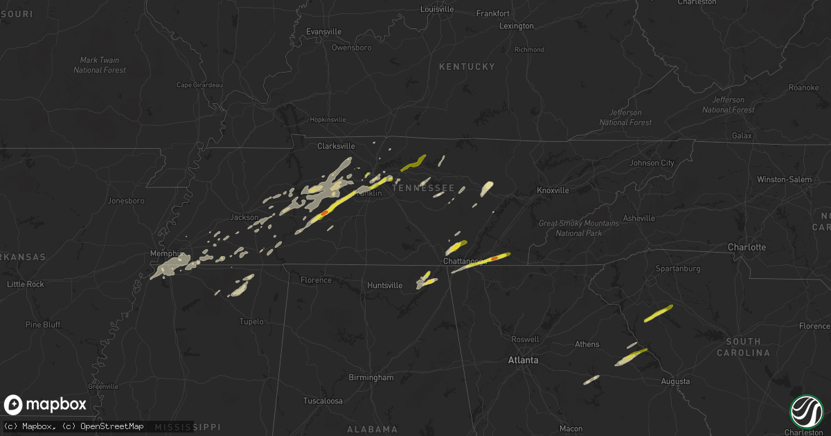
Hail Map in Tennessee on March 26, 2021
Get this storm
March 26 map
$229
one time, instant access
Download today. No call, no setup
Keep the $229
Bought the map and want the full workflow? Apply the entire $229 to a subscription within 7 days. None of it is wasted.
Every map, not just this one
This buys you this map. Subscription and you get every map we run, in the markets you choose from a few cities to whole states to nationwide. Plus real-time alerts the moment a storm fires.
Contact data
Name, contact info, occupancy, even credit band for addresses in the footprint. You go from where it hit to who to call.
Become the source they trust
Unlimited branding weather history reports on demand. You already have the documented answer ready for the property owner, and you are the one who showed up with it.
Property data and RoofTrace estimates
Pull up any address you have got, its value and the exact code rules for that jurisdiction, straight from One Click Code. Then RoofTrace estimates the squares, pitch, and roof value, priced the way you price.
Storm reports in Tennessee
Tennessee
| Date | Description |
|---|---|
| 03/26/20217:36 AM CDT | At 1236 AM EDT, a severe thunderstorm was located 9 miles southeast of Eagleton Village, or 10 miles east of Maryville, moving northeast at 60 mph. HAZARD...Ping pong ball size hail and 60 mph wind gusts. SOURCE...Radar indicated. IMPACT...People and animals outdoors will be injured. Expect hail damage to roofs, siding, windows, and vehicles. Expect wind damage to roofs, siding, and trees. Locations impacted include... Morristown, Sevierville, Jefferson City, Rogersville, Dandridge, Pigeon Forge, Bean Station, White Pine, New Market and Baneberry.This includes the following highways... Interstate 40 in Tennessee between mile markers 405 and 430. Interstate 81 in Tennessee between mile markers 1 and 37. |
| 03/26/20216:48 AM CDT | Reported on anderson road |
| 03/26/20216:40 AM CDT | Large tree down on cherry road near park in memphis. |
| 03/26/20216:36 AM CDT | Reported at 9475 smithson lane |
| 03/26/20216:00 AM CDT | Hail fell at the tva ocoee hydro plant along us hwy 64. |
| 03/26/20215:55 AM CDT | Nickel to quarter sized hail near polk county line. |
| 03/26/20215:35 AM CDT | Large tree down on cherry road near park in memphis. |
| 03/26/20215:18 AM CDT | Twitter photo of half dollar size hail on arnold road |
| 03/26/20214:40 AM CDT | Determined from a picture of hail that had fallen. In the sequatchie valley/stone cave area. Time and location approximated by radar. |
| 03/26/20214:35 AM CDT | From social media picture. |
| 03/26/20214:30 AM CDT | Picture of hail that was larger than a penny. |
| 03/26/20214:30 AM CDT | A local report indicates 1.50 inch wind near 1 N WHITWELL |
All States Impacted by Hail Map on March 26, 2021
Cities Impacted by Hail Map on March 26, 2021
- Cedar Grove, TN
- Yuma, TN
- Campbell, NE
- Bladen, NE
- Sparta, TN
- Clifton, TN
- Kingston Springs, TN
- White Bluff, TN
- Saulsbury, TN
- Nashville, TN
- Centerville, TN
- Lobelville, TN
- Chattanooga, TN
- Whitwell, TN
- Signal Mountain, TN
- Tracy City, TN
- Ripley, MS
- Blue Mountain, MS
- Dumas, MS
- Charlotte, TN
- Buckhead, GA
- Eatonton, GA
- Stevenson, AL
- Hollywood, AL
- Scottsboro, AL
- Flat Rock, AL
- Stanton, TN
- Greensboro, GA
- Goodlettsville, TN
- Fackler, AL
- Hodges, SC
- Bon Aqua, TN
- Dickson, TN
- McDonald, TN
- Apison, TN
- Cleveland, TN
- Hohenwald, TN
- Laurens, SC
- Waterloo, SC
- Donalds, SC
- Abbeville, SC
- Due West, SC
- Ware Shoals, SC
- Moscow, TN
- McEwen, TN
- Madison, GA
- Collierville, TN
- Brentwood, TN
- Lexington, TN
- Washington, GA
- Memphis, TN
- Lebanon, TN
- Whiteville, TN
- Smithville, TN
- Antioch, TN
- Lyles, TN
- Franklin, TN
- Myrtle, MS
- Old Fort, TN
- Ocoee, TN
- Hurricane Mills, TN
- Linn, KS
- Palmer, KS
- Greenleaf, KS
- Rossville, TN
- Holladay, TN
- Sugar Tree, TN
- Parsons, TN
- Linden, TN
- Darden, TN
- Waverly, TN
- Enville, TN
- Reagan, TN
- Henderson, TN
- Medon, TN
- Germantown, TN
- Corinth, MS
- Walnut, MS
- Rienzi, MS
- Crawfordville, GA
- Rayle, GA
- Lincolnton, GA
- Chapmansboro, TN
- Ashland City, TN
- Fairview, TN
- Cumberland Furnace, TN
- Burns, TN
- Only, TN
- Nunnelly, TN
- Somerville, TN
- Crossville, TN
- Edgar, NE
- Primm Springs, TN
- Duck River, TN
- Tignall, GA
- Rossville, GA
- Fort Oglethorpe, GA
- Rock Island, TN
- Doyle, TN
- Quebeck, TN
- Byhalia, MS
- Olive Branch, MS
- Westport, TN
- Huntingdon, TN
- Buena Vista, TN
- Hermitage, TN
- La Grange, TN
- Grand Junction, TN
- New Albany, MS
- Sequatchie, TN
- Dunlap, TN
- Palmer, TN
- Spring City, TN
- Middleton, TN
- Oakland, TN
- Williston, TN
- Lake Cormorant, MS
- Walls, MS
- Pocahontas, TN
- Hornsby, TN
- Jasper, TN
- Crump, TN
- Adamsville, TN
- Savannah, TN
- Pinson, TN
- Robinsonville, MS
- Cordova, TN
- Horn Lake, MS
- Nesbit, MS
- Eads, TN
- Southaven, MS
- Hernando, MS
- Santa Fe, TN
- Liberty, TN
- Mount Juliet, TN
- Bath Springs, TN
- Stantonville, TN
- Selmer, TN
- Hickory Flat, MS
- Auburntown, TN
- Arapahoe, NE
- Wildwood, GA
- Rising Fawn, GA
- Ringgold, GA
- Ooltewah, TN
- Flintstone, GA
- Lookout Mountain, GA
- Trenton, GA
- Benton, TN
- Camden, TN
- Millington, TN
- Gallatin, TN
- Granville, TN
- Gainesboro, TN
- Bolivar, TN
- Springfield, TN
- Cross Plains, TN
- Luray, TN
- Huron, TN
- Beech Bluff, TN
- Summertown, TN
- Alexandria, TN
- Hickman, TN
- Lancaster, TN
- Pikeville, TN
- Hickory Valley, TN
- Wildersville, TN
- Sardis, TN
- Milledgeville, TN
- Holbrook, NE
- Cambridge, NE
- Holstein, NE
- Edison, NE
- Pleasant Shade, TN
- Dixon Springs, TN
- Riddleton, TN
- Carthage, TN
- Washington, KS
- Barnes, KS
- Mountville, SC
- Iva, SC
- Huntsville, OH
- Solon, OH
- Columbus, OH
- Danville, OH
- Mount Sterling, OH
- Twinsburg, OH
- West Liberty, OH
- Delaware, OH
- Doylestown, OH
- Sterling, OH
- South Charleston, OH
- Hiram, OH
- Bellville, OH
- Lima, OH
- Fairborn, OH
- Limaville, OH
- Paris, OH
- Mogadore, OH
- Carrollton, OH
- Washingtonville, OH
- Northfield, OH
- Richwood, OH
- Holmesville, OH
- Wooster, OH
- Brookpark, OH
- Westlake, OH
- East Sparta, OH
- Cardington, OH
- Wilmington, OH
- Marysville, OH
- Southington, OH
- Mechanicstown, OH
- Jeffersonville, OH
- Damascus, OH
- London, OH
- Vienna, OH
- Mineral Ridge, OH
- Middlebranch, OH
- Frazeysburg, OH
- Lakewood, OH
- New Waterford, OH
- Killbuck, OH
- Ashley, OH
- Creston, OH
- Aurora, OH
- Barberton, OH
- Fredericktown, OH
- Lake Milton, OH
- Homerville, OH
- Xenia, OH
- Lewis Center, OH
- Zanesfield, OH
- Maplewood, OH
- Macedonia, OH
- Washington Court House, OH
- Hartville, OH
- West Mansfield, OH
- Hayesville, OH
- Kensington, OH
- Tiro, OH
- Glenmont, OH
- New Hampshire, OH
- Seville, OH
- Granville, OH
- Lagrange, OH
- Avon Lake, OH
- Minerva, OH
- South Solon, OH
- Johnstown, OH
- Alliance, OH
- Waynesfield, OH
- Centerburg, OH
- Malvern, OH
- Shreve, OH
- Chardon, OH
- Springfield, OH
- Leetonia, OH
- Kent, OH
- Lodi, OH
- Medina, OH
- Garrettsville, OH
- Niles, OH
- Ridgeway, OH
- Sebring, OH
- Spring Valley, OH
- Raymond, OH
- Roundhead, OH
- Ostrander, OH
- Lakeview, OH
- Loudonville, OH
- Bellbrook, OH
- Salem, OH
- Russells Point, OH
- Waynesburg, OH
- Shelby, OH
- North Lewisburg, OH
- Wakeman, OH
- Berlin Heights, OH
- Newbury, OH
- Radnor, OH
- Tallmadge, OH
- Broadway, OH
- Utica, OH
- Mingo, OH
- Port William, OH
- Irwin, OH
- East Liberty, OH
- Galena, OH
- Kipton, OH
- Atwater, OH
- Alger, OH
- Cable, OH
- Grove City, OH
- Cedarville, OH
- Ashland, OH
- Homeworth, OH
- Galion, OH
- Millersburg, OH
- Mount Victory, OH
- Beloit, OH
- Bristolville, OH
- Bedford, OH
- Dayton, OH
- Edison, OH
- Croton, OH
- Rushsylvania, OH
- Cleveland, OH
- Urbana, OH
- Crestline, OH
- Wapakoneta, OH
- Ravenna, OH
- Fulton, OH
- Powell, OH
- Rocky River, OH
- Salineville, OH
- Butler, OH
- Bellefontaine, OH
- Smithville, OH
- Deerfield, OH
- Brewster, OH
- Sullivan, OH
- Uniontown, OH
- Woodstock, OH
- Newton Falls, OH
- Middlefield, OH
- North Olmsted, OH
- Chesterville, OH
- Youngstown, OH
- Leavittsburg, OH
- Summitville, OH
- Prospect, OH
- Independence, OH
- Akron, OH
- East Rochester, OH
- Columbiana, OH
- Stow, OH
- Green Camp, OH
- West Salem, OH
- Magnetic Springs, OH
- Miamisburg, OH
- Martinsburg, OH
- Big Prairie, OH
- Nova, OH
- North Bloomfield, OH
- North Jackson, OH
- Rogers, OH
- Burton, OH
- Ada, OH
- Clinton, OH
- Westerville, OH
- Enon, OH
- Huntsburg, OH
- Wadsworth, OH
- North Canton, OH
- Brecksville, OH
- Warren, OH
- Morral, OH
- Norwalk, OH
- Mount Vernon, OH
- Novelty, OH
- Canfield, OH
- North Lawrence, OH
- Marengo, OH
- Windham, OH
- Chagrin Falls, OH
- Dublin, OH
- Plymouth, OH
- Olmsted Falls, OH
- Milford Center, OH
- Uniopolis, OH
- Beach City, OH
- Oberlin, OH
- Avon, OH
- Newark, OH
- Mechanicsburg, OH
- McGuffey, OH
- Caledonia, OH
- Marion, OH
- Coshocton, OH
- Canal Fulton, OH
- Amherst, OH
- Burbank, OH
- Walhonding, OH
- Diamond, OH
- Rootstown, OH
- Amlin, OH
- Kenton, OH
- Dalton, OH
- Massillon, OH
- Girard, OH
- West Farmington, OH
- Beachwood, OH
- Lucas, OH
- Collins, OH
- Gates Mills, OH
- Yellow Springs, OH
- Perrysville, OH
- Robertsville, OH
- Sabina, OH
- Hilliard, OH
- Jamestown, OH
- Fredericksburg, OH
- Alpha, OH
- Lakeville, OH
- De Graff, OH
- Shiloh, OH
- Howard, OH
- Cuyahoga Falls, OH
- Spencer, OH
- Lakemore, OH
- Jeromesville, OH
- Orrville, OH
- Apple Creek, OH
- Warsaw, OH
- Bay Village, OH
- Mount Gilead, OH
- Saint Louisville, OH
- Munroe Falls, OH
- Bucyrus, OH
- Hanoverton, OH
- Farmdale, OH
- Gambier, OH
- New London, OH
- North Lima, OH
- Rittman, OH
- Wilberforce, OH
- Marshallville, OH
- West Jefferson, OH
- New Bloomington, OH
- Sparta, OH
- North Benton, OH
- Hudson, OH
- Quincy, OH
- South Vienna, OH
- North Fairfield, OH
- Mount Eaton, OH
- Belle Center, OH
- Lewistown, OH
- Harrod, OH
- Greenwich, OH
- Mantua, OH
- Litchfield, OH
- East Canton, OH
- Richfield, OH
- Plain City, OH
- Catawba, OH
- Galloway, OH
- Fowler, OH
- Streetsboro, OH
- Alexandria, OH
- La Rue, OH
- Polk, OH
- Waldo, OH
- Mansfield, OH
- Louisville, OH
- Bloomingburg, OH
- Cortland, OH
- Dundee, OH
- Maple Heights, OH
- Canton, OH
- Jackson Center, OH
- Brinkhaven, OH
- Peninsula, OH
- Sunbury, OH
- Lisbon, OH
- Navarre, OH
- Wellington, OH
- Berlin Center, OH
- Lorraine, NY
- Lacona, NY
- Copenhagen, NY
- Lowville, NY
- Mannsville, NY
- Croghan, NY
- Carthage, NY
- Castorland, NY
- Long Lake, NY
- Eagle Bay, NY
- Piseco, NY
- Blue Mountain Lake, NY
- Schroon Lake, NY
- North Hudson, NY
- Minerva, NY
- Olmstedville, NY
- Newcomb, NY
- Ticonderoga, NY
- Bridport, VT
- Whiting, VT
- Crown Point, NY
- Paradox, NY
- Shoreham, VT
- Middlebury, VT
- Moretown, VT
- Montpelier, VT
- McCormick, SC


