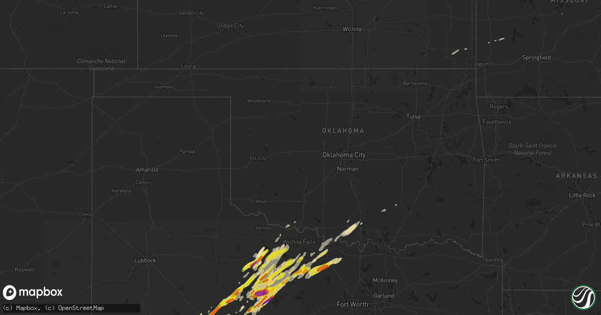
Hail Map in Oklahoma on March 26, 2018
Get this storm
March 26 map
$229
one time, instant access
Download today. No call, no setup
Keep the $229
Bought the map and want the full workflow? Apply the entire $229 to a subscription within 7 days. None of it is wasted.
Every map, not just this one
This buys you this map. Subscription and you get every map we run, in the markets you choose from a few cities to whole states to nationwide. Plus real-time alerts the moment a storm fires.
Contact data
Name, contact info, occupancy, even credit band for addresses in the footprint. You go from where it hit to who to call.
Become the source they trust
Unlimited branding weather history reports on demand. You already have the documented answer ready for the property owner, and you are the one who showed up with it.
Property data and RoofTrace estimates
Pull up any address you have got, its value and the exact code rules for that jurisdiction, straight from One Click Code. Then RoofTrace estimates the squares, pitch, and roof value, priced the way you price.
Storm reports in Oklahoma
Oklahoma
| Date | Description |
|---|---|
| 03/26/20187:35 AM CDT | At 1234 PM CDT, two severe thunderstorms were located near Nocona to near Newport, moving northeast at 50 mph. HAZARD...Quarter size hail. SOURCE...Law enforcement. IMPACT...Damage to vehicles is possible. Locations impacted include... Bowie, Nocona and Stoneburg. |
| 03/26/20185:40 AM CDT | At 1039 PM CDT, a severe thunderstorm was located 4 miles northeast of Fitzhugh, moving east at 45 mph. HAZARD...60 mph wind gusts and penny size hail. SOURCE...Radar indicated. IMPACT...Expect damage to roofs, siding, and trees. Locations impacted include... Ada, Allen, Stonewall, Tupelo, Calvin, Fitzhugh, Stuart, Gerty, Centrahoma, Atwood, Fittstown and Jesse. |
| 03/26/20185:18 AM CDT | At 1018 PM CDT, a severe thunderstorm was located 4 miles north of Sulphur, moving east at 45 mph. HAZARD...60 mph wind gusts and penny size hail. SOURCE...Radar indicated. IMPACT...Expect damage to roofs, siding, and trees. Locations impacted include... Ada, Sulphur, Roff, Stonewall, Fitzhugh, Hickory, Scullin, Fittstown and Jesse. |
| 03/25/201811:11 PM CDT | Several large tree branches broken. |
| 03/25/20189:48 PM CDT | At 248 PM CDT, a severe thunderstorm was located over northwestern Wichita Falls, moving northeast at 40 mph. HAZARD...60 mph wind gusts and nickel size hail. SOURCE...Radar indicated. IMPACT...Expect damage to roofs, siding, and trees. Locations impacted include... Wichita Falls, Burkburnett, Iowa Park, Temple, Petrolia, Byers, Dean, Randlett, Jolly, Sheppard AFB, Pleasant Valley, Taylor, Charlie and Cashion.This includes Interstate 44 between mile markers 0 and 3. |
Cities Impacted by Hail Map on March 26, 2018
- Big Lake, TX
- Midkiff, TX
- Garden City, TX
- Sterling City, TX
- Crane, TX
- Merkel, TX
- Abilene, TX
- Montague, TX
- Bowie, TX
- Sunset, TX
- Forestburg, TX
- Jacksboro, TX
- Sweetwater, TX
- Roby, TX
- Holts Summit, MO
- Tebbetts, MO
- Buffalo Gap, TX
- Tuscola, TX
- Holliday, TX
- Seymour, TX
- Mertzon, TX
- McCamey, TX
- Midland, TX
- Scotland, TX
- Windthorst, TX
- Woodson, TX
- Lone Grove, OK
- Wilson, OK
- Throckmorton, TX
- Maryneal, TX
- Blackwell, TX
- Robert Lee, TX
- Bellevue, TX
- Nocona, TX
- Fort Stockton, TX
- Ardmore, OK
- Glasgow, MO
- Cherokee, KS
- Ozona, TX
- Newcastle, TX
- Rule, TX
- Stamford, TX
- Anson, TX
- McCaulley, TX
- Hamlin, TX
- Dryden, TX
- Electra, TX
- Albany, TX
- Haskell, TX
- Westbrook, TX
- Sylvester, TX
- Saint Jo, TX
- Graham, TX
- Lueders, TX
- Archer City, TX
- Loving, TX
- Breckenridge, TX
- Jermyn, TX
- Loraine, TX
- Henrietta, TX
- Bryson, TX
- Olney, TX
- Colorado City, TX
- Iowa Park, TX
- Avoca, TX
- Roscoe, TX
- Rankin, TX
- Wingate, TX
- Munday, TX
- Goree, TX
- Bronte, TX
- Winters, TX
- Lamar, MO
- Hawley, TX
- Ringling, OK
- Higbee, MO
- Huntsville, MO
- Trent, TX
- Camdenton, MO
- Armstrong, MO
- Devol, OK
- Columbia, MO
- Weinert, TX
- Stonewall, OK
- Tishomingo, OK
- Carlsbad, TX
- Slater, MO
- Gilliam, MO
- Norton, TX
- Portland, MO
- Overbrook, OK
- California, MO
- Lockwood, MO
- Grandfield, OK
- Lawn, TX
- Eldorado, TX
- Terral, OK
- Ryan, OK
- Ovalo, TX
- Healdton, OK
- Pleasant Hill, MO
- Ringgold, TX
- Knox City, TX
- Greenwood, MO
- Lone Jack, MO
- Centrahoma, OK
- Dyess Afb, TX
- Tye, TX
- Oswego, KS
- McCune, KS
- Saint James, MO
- Cuba, MO
- Jefferson City, MO
- Lohman, MO
- Harrisonville, MO
- Lees Summit, MO
- Peculiar, MO
- O'Brien, TX
- Chico, TX


