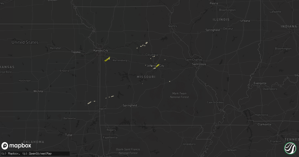
Hail Map in Missouri on March 26, 2018
Get this storm
March 26 map
$229
one time, instant access
Download today. No call, no setup
Keep the $229
Bought the map and want the full workflow? Apply the entire $229 to a subscription within 7 days. None of it is wasted.
Every map, not just this one
This buys you this map. Subscription and you get every map we run, in the markets you choose from a few cities to whole states to nationwide. Plus real-time alerts the moment a storm fires.
Contact data
Name, contact info, occupancy, even credit band for addresses in the footprint. You go from where it hit to who to call.
Become the source they trust
Unlimited branding weather history reports on demand. You already have the documented answer ready for the property owner, and you are the one who showed up with it.
Property data and RoofTrace estimates
Pull up any address you have got, its value and the exact code rules for that jurisdiction, straight from One Click Code. Then RoofTrace estimates the squares, pitch, and roof value, priced the way you price.
Storm reports in Missouri
Missouri
| Date | Description |
|---|---|
| 03/26/20188:45 AM CDT | Hail covering the ground. |
| 03/26/20187:23 AM CDT | Observed at wfo eax. |
| 03/26/20186:21 AM CDT | At 1121 AM CDT, a severe thunderstorm was located over Lamar, moving northeast at 45 mph. HAZARD...Quarter size hail. SOURCE...Radar indicated. IMPACT...Damage to vehicles is expected. Locations impacted include... Stockton Lake... Stockton State Park... Lamar... Stockton... Jerico Springs... Lamar Heights... Arcola... Umber View Heights... Milford... Bearcreek... Masters... Olympia... Caplinger Mills... Wagoner... Cane Hill... Arnica... Kenoma... Filley... Cedarville... Sylvania...This includes Interstate 49 between mile markers 63 and 71. |
| 03/26/20185:45 AM CDT | At 1045 AM CDT, a severe thunderstorm was located near Oswego, moving northeast at 55 mph. HAZARD...Quarter size hail. SOURCE...Radar indicated. IMPACT...Damage to vehicles is expected. Locations impacted include... Pittsburg... Prairie State Park... Lamar... Frontenac... Arma... Liberal... Cherokee... Weir... Sherman... Mulberry... Scammon... Chicopee... Mccune... Nashville... Mindenmines... Franklin... Asbury... West Mineral... Lamar Heights... Roseland...This includes Interstate 49 between mile markers 57 and 69. |
| 03/26/20183:29 AM CDT | At 829 AM CDT, a severe thunderstorm was located near Holts Summit, moving northeast at 35 mph. HAZARD...Quarter size hail. SOURCE...Radar indicated. IMPACT...Damage to vehicles is expected. Locations impacted include... Jefferson City, Fulton, Holts Summit, Lake Mykee Town, Lake Mykee, Mokane, Wainwright, Tebbetts, Reform and Steedman. |
| 03/26/20183:21 AM CDT | At 821 AM CDT, a severe thunderstorm was located 8 miles south of Osage Beach, moving northeast at 55 mph. HAZARD...Quarter size hail. SOURCE...Radar indicated. IMPACT...Damage to vehicles is expected. Locations impacted include... Lake of The Ozarks... Lake of The Ozarks State Park... Osage Beach... Iberia... Vienna... Saint Elizabeth... St. Elizabeth... Linn Creek... Tuscumbia... Brumley... Ulman... Freedom... Kaiser... Marys Home... Montreal... |
| 03/26/20181:38 AM CDT | At 638 AM CDT, a severe thunderstorm was located near Louisburg, moving northeast at 35 mph. HAZARD...Quarter size hail. SOURCE...Trained weather spotters. IMPACT...Damage to vehicles is expected. Locations impacted include... Grandview, Belton, Raymore, Peculiar, Louisburg, Cleveland and Bucyrus. |
| 03/26/201812:37 AM CDT | At 537 AM CDT, a severe thunderstorm was located near Pocahontas, moving east northeast at 35 mph. HAZARD...Half dollar size hail. SOURCE...Trained weather spotters. IMPACT...Damage to vehicles is expected. Locations impacted include... Pocahontas, Corning, Reyno, Maynard, Biggers, Knobel, Success, Peach Orchard, Delaplaine, Datto, Attica, Middlebrook, Ingram, Brookings, Twin Oaks, Palatka, Heelstring, Elkins Park, Brakebill and Warm Springs. |
| 03/25/201811:58 PM CDT | At 457 AM CDT, a severe thunderstorm was located 8 miles southeast of Willow Springs, moving northeast at 20 mph. HAZARD...Quarter size hail. SOURCE...Radar indicated. IMPACT...Damage to vehicles is expected. Locations impacted include... Mountain View... Montier... Teresita... Peace Valley... |
Cities Impacted by Hail Map on March 26, 2018
- Big Lake, TX
- Midkiff, TX
- Garden City, TX
- Sterling City, TX
- Crane, TX
- Merkel, TX
- Abilene, TX
- Montague, TX
- Bowie, TX
- Sunset, TX
- Forestburg, TX
- Jacksboro, TX
- Sweetwater, TX
- Roby, TX
- Holts Summit, MO
- Tebbetts, MO
- Buffalo Gap, TX
- Tuscola, TX
- Holliday, TX
- Seymour, TX
- Mertzon, TX
- McCamey, TX
- Midland, TX
- Scotland, TX
- Windthorst, TX
- Woodson, TX
- Lone Grove, OK
- Wilson, OK
- Throckmorton, TX
- Maryneal, TX
- Blackwell, TX
- Robert Lee, TX
- Bellevue, TX
- Nocona, TX
- Fort Stockton, TX
- Ardmore, OK
- Glasgow, MO
- Cherokee, KS
- Ozona, TX
- Newcastle, TX
- Rule, TX
- Stamford, TX
- Anson, TX
- McCaulley, TX
- Hamlin, TX
- Dryden, TX
- Electra, TX
- Albany, TX
- Haskell, TX
- Westbrook, TX
- Sylvester, TX
- Saint Jo, TX
- Graham, TX
- Lueders, TX
- Archer City, TX
- Loving, TX
- Breckenridge, TX
- Jermyn, TX
- Loraine, TX
- Henrietta, TX
- Bryson, TX
- Olney, TX
- Colorado City, TX
- Iowa Park, TX
- Avoca, TX
- Roscoe, TX
- Rankin, TX
- Wingate, TX
- Munday, TX
- Goree, TX
- Bronte, TX
- Winters, TX
- Lamar, MO
- Hawley, TX
- Ringling, OK
- Higbee, MO
- Huntsville, MO
- Trent, TX
- Camdenton, MO
- Armstrong, MO
- Devol, OK
- Columbia, MO
- Weinert, TX
- Stonewall, OK
- Tishomingo, OK
- Carlsbad, TX
- Slater, MO
- Gilliam, MO
- Norton, TX
- Portland, MO
- Overbrook, OK
- California, MO
- Lockwood, MO
- Grandfield, OK
- Lawn, TX
- Eldorado, TX
- Terral, OK
- Ryan, OK
- Ovalo, TX
- Healdton, OK
- Pleasant Hill, MO
- Ringgold, TX
- Knox City, TX
- Greenwood, MO
- Lone Jack, MO
- Centrahoma, OK
- Dyess Afb, TX
- Tye, TX
- Oswego, KS
- McCune, KS
- Saint James, MO
- Cuba, MO
- Jefferson City, MO
- Lohman, MO
- Harrisonville, MO
- Lees Summit, MO
- Peculiar, MO
- O'Brien, TX
- Chico, TX


