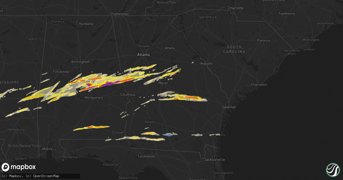
Hail Map in Georgia on March 25, 2023
Get this storm
March 25 map
$229
one time, instant access
Download today. No call, no setup
Keep the $229
Bought the map and want the full workflow? Apply the entire $229 to a subscription within 7 days. None of it is wasted.
Every map, not just this one
This buys you this map. Subscription and you get every map we run, in the markets you choose from a few cities to whole states to nationwide. Plus real-time alerts the moment a storm fires.
Contact data
Name, contact info, occupancy, even credit band for addresses in the footprint. You go from where it hit to who to call.
Become the source they trust
Unlimited branding weather history reports on demand. You already have the documented answer ready for the property owner, and you are the one who showed up with it.
Property data and RoofTrace estimates
Pull up any address you have got, its value and the exact code rules for that jurisdiction, straight from One Click Code. Then RoofTrace estimates the squares, pitch, and roof value, priced the way you price.
Storm reports in Georgia
Georgia
| Date | Description |
|---|---|
| 03/25/20235:27 PM CDT | Golf ball sized hail reported at 911 call center. |
| 03/25/20234:45 PM CDT | Two trees and one power line down along gardner road. |
| 03/25/20234:40 PM CDT | A picture of a tree across a road in the pavo area was posted on social media. |
| 03/25/20234:30 PM CDT | Caller reported 1.5 inch sized hail near harrington street and oak park hwy. |
| 03/25/20234:10 PM CDT | Trees down at the intersection of hwy 117 and cj bedingfield rd. |
| 03/25/20234:06 PM CDT | Tree down on salem rd at salem church rd. |
| 03/25/20234:00 PM CDT | Tree down on harrell rd. |
| 03/25/20233:58 PM CDT | Tree down on newton rd at mm 23. |
| 03/25/20233:54 PM CDT | Tree down at pine level rd and owens rd. |
| 03/25/20233:54 PM CDT | Tree on powerline at spring hill rd and hwy 112n. |
| 03/25/20233:49 PM CDT | Tree down at lothair church rd and hwy 199. |
| 03/25/20233:44 PM CDT | Trees down at intersection of hwy 199s and thairdale rd. |
| 03/25/20233:40 PM CDT | Multiple trees down near the intersection of mister rd and highway 82. Time estimated from radar. |
| 03/25/20233:40 PM CDT | Tree blocking w fancy bluff rd as reported by 911 dispatch. Time estimated from radar. |
| 03/25/20233:35 PM CDT | Tree down at intersection of pelham rd and old pelham rd. |
| 03/25/20233:30 PM CDT | 911 call center reported quarter sized hail at the intersection of perry hwy and truman rd. |
| 03/25/20233:23 PM CDT | Tree down on salem church road. |
| 03/25/20233:19 PM CDT | Wires down at intersection of meeks rd and hwy 441. |
| 03/25/20232:59 PM CDT | Hail associated with a severe warned storm dented a vehicle in dexter... Ga. |
| 03/25/20232:50 PM CDT | Tree limb down on lane bridge road. |
| 03/25/20232:40 PM CDT | 911 dispatch reports power lines down on swamp road in southern ware county. Time estimated from radar. |
| 03/25/20231:34 PM CDT | Tree down on river rd. |
| 03/25/20231:14 PM CDT | Ambient weather mesonet site griffin ag measured a 58 mph gust. |
| 03/25/20231:13 PM CDT | Trees down on hwy 125 near allenville rd. |
| 03/25/20231:11 PM CDT | Cable lines down reported near industrial park blvd and may ave. |
| 03/25/20231:09 PM CDT | Tree down on nashville enigma rd near the nashville city limits. |
| 03/25/202312:53 PM CDT | Tree down on county farm rd at mcconnel bridge rd. |
| 03/25/202312:53 PM CDT | Power outages and a couple of trees down across old union road. |
| 03/25/202312:45 PM CDT | Couple of downed powerlines. 1 tree fell on a vehicle... Damaging its roof. Couple of tree tops broke off and landed on roofs. |
| 03/25/202312:24 PM CDT | Utility pole reported down. |
| 03/25/202312:17 PM CDT | Power lines down on highway 37 west. |
| 03/25/202312:08 PM CDT | Tree down near gin creek. |
| 03/25/202311:53 AM CDT | Tree down on john collins road. |
| 03/25/202311:52 AM CDT | 2 trees down on johnny freeman rd in colquitt... Ga |
| 03/25/202311:44 AM CDT | A local report indicates 1.50 inch wind near 2 ESE CAMILLA |
| 03/25/202311:42 AM CDT | Corrects time of previous tstm wnd dmg report from 1 ssw camilla. Tree down on newton rd at mm 23. |
| 03/25/202311:40 AM CDT | Tree down near the intersection of highway 37 and river road. |
| 03/25/202311:30 AM CDT | Corrects previous tstm wnd dmg report from 3 s elmodel wma. 2 trees down along jericho rd. |
| 03/25/202311:18 AM CDT | Tree down on josuli rd. |
| 03/25/202311:00 AM CDT | A large pine tree was blown over with downed power lines along old ga highway 3 in mitchell county. |
| 03/25/202310:30 AM CDT | Corrects time of previous tstm wnd dmg report from 3 s elmodel wma. 2 trees down along jericho rd. |
| 03/25/20236:45 AM CDT | The emergency services building sustained considerable roof damage. A tree fell on an ambulance. |
| 03/25/20236:43 AM CDT | Multiple trees and powerlines down across north milledgeville. The hospital sustained roof damage. |
| 03/25/20236:40 AM CDT | Several trees and powerlines down near the intersection of mlk and jefferson st. |
| 03/25/20236:26 AM CDT | Report via social media for north baldwin county. |
| 03/25/20236:10 AM CDT | A local report indicates 1.50 inch wind near HOLLONVILLE |
| 03/25/20236:06 AM CDT | Numerous trees snapped on either side of i-185 in a stretch between oak grove rd and salem rd. |
| 03/25/20236:00 AM CDT | Multiple trees and powerlines down near oak grove rd nw of pine mountain ga. |
| 03/25/20236:00 AM CDT | Several reports of ping pong to golf ball sized hail in lagrange from severe warned storm. Reports via social media. |
| 03/25/20236:00 AM CDT | Trees down along niles street. |
| 03/25/20235:53 AM CDT | Multiple trees snapped and uprooted along shoemarker rd near west point. Damage to residences was also noted along shoemarker rd. |
| 03/25/20235:20 AM CDT | Trees reported down on lockett rd. |
| 03/25/20235:16 AM CDT | Report via social media. |
| 03/25/20234:47 AM CDT | Report via social media. |
| 03/25/20234:40 AM CDT | Near the intersection of werner way and seavy street. |
| 03/25/20234:30 AM CDT | Report via social media. |
| 03/25/20234:00 AM CDT | 1 inch hail and 50e mph winds at lower big springs rd and stovall rd se of lagrange. |
| 03/25/20233:55 AM CDT | Ping pong ball sized hail reported south of lagrange on salem... Whitesville... And hamilton rds. |
| 03/24/20239:50 PM CDT | Half dollar sized hail reported by emergency manager along hwy 228 near lacross rd. |
All States Impacted by Hail Map on March 25, 2023
Cities Impacted by Hail Map on March 25, 2023
- Lake Village, AR
- Dermott, AR
- Greenville, MS
- Benoit, MS
- Cleveland, MS
- Beulah, MS
- Boyle, MS
- Merigold, MS
- Ruleville, MS
- Mound Bayou, MS
- Drew, MS
- Parchman, MS
- Tutwiler, MS
- Charleston, MS
- Sumner, MS
- Rolling Fork, MS
- Mayersville, MS
- Anguilla, MS
- Enid, MS
- Louise, MS
- Silver City, MS
- Pope, MS
- Belzoni, MS
- Sheffield, AL
- Florence, AL
- Muscle Shoals, AL
- Killen, AL
- Rogersville, AL
- Lexington, AL
- Anderson, AL
- Athens, AL
- Elkmont, AL
- Lester, AL
- Detroit, AL
- Hamilton, AL
- Haleyville, AL
- Bear Creek, AL
- Hackleburg, AL
- Ashford, AL
- Columbia, AL
- Moultrie, GA
- Adel, GA
- Norman Park, GA
- Bedford, OH
- Cleveland, OH
- Beachwood, OH
- Maple Heights, OH
- Solon, OH
- Chagrin Falls, OH
- Novelty, OH
- Chesterland, OH
- Gates Mills, OH
- Willoughby, OH
- Newbury, OH
- Sparks, GA
- Dry Branch, GA
- Perry, GA
- Bonaire, GA
- Kathleen, GA
- Jeffersonville, GA
- Cochran, GA
- Fort Valley, GA
- Pelham, GA
- Sale City, GA
- Camilla, GA
- Hartsfield, GA
- Meigs, GA
- Independence, OH
- Hartford, AL
- Doerun, GA
- Columbia Station, OH
- Brookpark, OH
- Broadview Heights, OH
- Berea, OH
- Strongsville, OH
- Brecksville, OH
- North Royalton, OH
- Chardon, OH
- Burton, OH
- Nashville, GA
- Huntsburg, OH
- Montville, OH
- Thompson, OH
- Painesville, OH
- Madison, OH
- Rock Creek, OH
- Geneva, OH
- Rome, OH
- Windsor, OH
- Austinburg, OH
- Ashtabula, OH
- Jefferson, OH
- Pierpont, OH
- Kingsville, OH
- Conneaut, OH
- North Kingsville, OH
- Newton Falls, OH
- Leavittsburg, OH
- Warren, OH
- Cortland, OH
- Dexter, GA
- Dudley, GA
- Rentz, GA
- Dublin, GA
- Hawkinsville, GA
- Glenwood, GA
- Rockledge, GA
- Soperton, GA
- Tarrytown, GA
- Chester, GA
- Evergreen, AL
- Castleberry, AL
- Eastman, GA
- Cadwell, GA
- Vidalia, GA
- Red Level, AL
- Twin City, GA
- Lyons, GA
- Swainsboro, GA
- Metter, GA
- Cobbtown, GA
- Andalusia, AL
- Dozier, AL
- Opp, AL
- Gantt, AL
- Elba, AL
- New Brockton, AL
- Gordon, AL
- Bonifay, FL
- Brinson, GA
- Colquitt, GA
- Bainbridge, GA
- Ellaville, GA
- Whigham, GA
- Climax, GA
- Brunswick, GA
- Iron City, GA
- Donalsonville, GA
- Elko, GA
- Unadilla, GA
- Oglethorpe, GA
- Andersonville, GA
- Montezuma, GA
- Waynesville, GA
- Waverly, GA
- East Dublin, GA
- Black, AL
- Cairo, GA
- Ochlocknee, GA
- Lumpkin, GA
- Preston, GA
- Weston, GA
- Richland, GA
- Newton, GA
- Plains, GA
- Americus, GA
- Coolidge, GA
- Pavo, GA
- Danville, GA
- Waycross, GA
- Thomasville, GA
- Slocomb, AL
- Hoboken, GA
- Collins, GA
- Jakin, GA
- Marianna, FL
- Cottonwood, AL
- Barney, GA
- Graceville, FL
- Campbellton, FL
- Montrose, GA
- Eufaula, AL
- Georgetown, GA
- Morris, GA
- Mount Vernon, GA
- Abbeville, AL
- Fort Gaines, GA
- Enterprise, AL
- Fort Rucker, AL
- Cuthbert, GA
- Campbell, NE
- Ozark, AL
- Ailey, GA
- Claxton, GA
- Register, GA
- Equality, AL
- Eclectic, AL
- Alexander City, AL
- Dadeville, AL
- Jacksons Gap, AL
- Camp Hill, AL
- Lafayette, AL
- Wetumpka, AL
- Jones, AL
- Billingsley, AL
- Prattville, AL
- Marbury, AL
- Deatsville, AL
- Verbena, AL
- Buena Vista, GA
- Ideal, GA
- Marshallville, GA
- Waverly, AL
- Marion, AL
- Centreville, AL
- Lawley, AL
- Brandon, MS
- Titus, AL
- Lanett, AL
- Lagrange, GA
- Valley, AL
- West Point, GA
- Rockford, AL
- Randolph, AL
- Maplesville, AL
- Thorsby, AL
- Jemison, AL
- Clanton, AL
- Weogufka, AL
- Pine Mountain, GA
- Greenville, GA
- Warm Springs, GA
- Five Points, AL
- Sylacauga, AL
- Goodwater, AL
- Kellyton, AL
- Hickory, MS
- Chunky, MS
- Enterprise, MS
- Meridian, MS
- Marion, MS
- Brent, AL
- Toomsuba, MS
- Lauderdale, MS
- Woodbury, GA
- Gay, GA
- Molena, GA
- Newnan, GA
- Moreland, GA
- Grantville, GA
- Senoia, GA
- Sharpsburg, GA
- Fayetteville, GA
- Brooks, GA
- Zebulon, GA
- Meansville, GA
- Barnesville, GA
- Milner, GA
- Daviston, AL
- Wadley, AL
- Shelby, AL
- Cuba, AL
- York, AL
- Forsyth, GA
- Hogansville, GA
- Luthersville, GA
- Laurel, MS
- Bay Springs, MS
- Heidelberg, MS
- Gray, GA
- Juliette, GA
- Vossburg, MS
- Paulding, MS
- Sweet Water, AL
- Linden, AL
- Gallion, AL
- Hillsboro, GA
- Faunsdale, AL
- Haddock, GA
- Hampton, GA
- Griffin, GA
- Locust Grove, GA
- Pachuta, MS
- Quitman, MS
- Uniontown, AL
- Thomaston, AL
- Milledgeville, GA
- Sparta, GA
- Marion Junction, AL
- Concord, GA
- Thomaston, GA
- Selma, AL
- Williamson, GA
- Livingston, AL
- Aliceville, AL
- Yatesville, GA
- Culloden, GA
- Jackson, GA
- Pantego, NC
- Pinetown, NC
- Washington, NC
- Roanoke, AL
- Columbia, NC
- Fairfield, NC
- Ward, AL
- Lisman, AL
- Demopolis, AL
- Bellamy, AL
- Jachin, AL
- Engelhard, NC
- Montevallo, AL
- Brierfield, AL
- Morton, MS
- Eatonton, GA
- Lena, MS
- Forest, MS
- Belhaven, NC
- Plantersville, AL
- Walnut Grove, MS
- Carthage, MS
- Taylorsville, MS
- Mount Olive, MS
- Greenville, NC
- Farmville, NC
- Stantonsburg, NC
- Fremont, NC
- Walstonburg, NC
- Manchester, GA
- Newbern, AL
- Macon, GA
- Macclesfield, NC
- Stokes, NC
- Robersonville, NC
- Fountain, NC
- Bethel, NC
- Tarboro, NC
- Williamston, NC
- Monticello, GA
- Jackson, MS
- Greensboro, AL
- Ashland, AL
- Eutaw, AL
- Newton, MS
- Louin, MS
- Boligee, AL
- Stanton, AL
- Union, MS
- De Kalb, MS
- Philadelphia, MS
- Collinsville, MS
- Pelahatchie, MS
- Ridgeland, MS
- Franklin, GA
- Mcdonough, GA
- Bailey, MS
- Peachtree City, GA
- Autaugaville, AL
- The Rock, GA
- Thomson, GA
- White Plains, GA
- Flovilla, GA
- Toxey, AL
- Butler, AL
- Needham, AL
- Stringer, MS
- Calera, AL
- Gordon, GA
- Emelle, AL
- Mize, MS
- Jenkinsburg, GA
- Covington, GA
- Forkland, AL
- Waves, NC
- Salvo, NC
- Rodanthe, NC
- Plymouth, NC
- Sawyerville, AL
- Cragford, AL
- Akron, AL
- Collins, MS
- Shubuta, MS
- Porterville, MS
- Moundville, AL
- Pennington, AL
- Daleville, MS
- Epes, AL


