Hail Map in Alabama on March 25, 2023
Get this storm
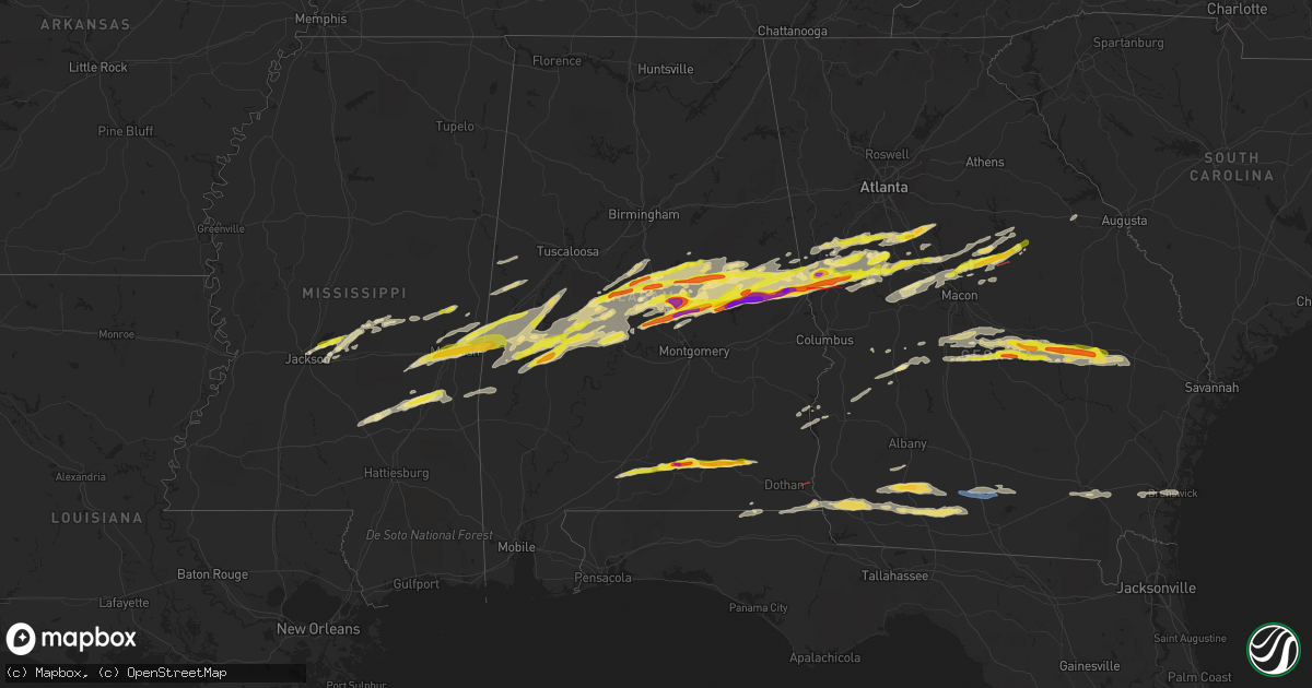
March 25 map
$229
one time, instant access
Download today. No call, no setup
Keep the $229
Bought the map and want the full workflow? Apply the entire $229 to a subscription within 7 days. None of it is wasted.
Every map, not just this one
This buys you this map. Subscription and you get every map we run, in the markets you choose from a few cities to whole states to nationwide. Plus real-time alerts the moment a storm fires.
Contact data
Name, contact info, occupancy, even credit band for addresses in the footprint. You go from where it hit to who to call.
Become the source they trust
Unlimited branding weather history reports on demand. You already have the documented answer ready for the property owner, and you are the one who showed up with it.
Property data and RoofTrace estimates
Pull up any address you have got, its value and the exact code rules for that jurisdiction, straight from One Click Code. Then RoofTrace estimates the squares, pitch, and roof value, priced the way you price.
Storm reports in Alabama
Alabama
| Date | Description |
|---|---|
| 03/25/20235:27 PM CDT | Public report of golf ball size hail in the new brockton area. |
| 03/25/20235:07 PM CDT | Public reported golf ball size hail in elba. Report relayed via wdhn media. |
| 03/25/20234:33 PM CDT | Public report to broadcast media of golf ball sized hail. |
| 03/25/20234:29 PM CDT | Social media report of hen egg size hail |
| 03/25/20234:17 PM CDT | Golf ball sized hail reported by public. |
| 03/25/20234:17 PM CDT | Public report of hail at gantt. This is a correction to a previous report. |
| 03/25/20239:10 AM CDT | Damage along goodson road corresponds to tornadic debris signature |
| 03/25/20239:06 AM CDT | Houston em reports several spots of damage between columbia and ashford... Al. Tornado confirmed by radar and eye witnesses. |
| 03/25/20238:08 AM CDT | Tree down on s county road 61. |
| 03/25/20236:42 AM CDT | The metal roof was ripped off a home in the holiday shores neighborhood along lake jordan. |
| 03/25/20236:41 AM CDT | Public report of quarter size hail near the coosa/elmore county line. |
| 03/25/20236:35 AM CDT | Reported via social media. Time estimated from radar. |
| 03/25/20236:18 AM CDT | Tree limbs reported down north of marion junction. |
| 03/25/20236:17 AM CDT | Social media report of ping pong ball sized hail near verbena. |
| 03/25/20236:15 AM CDT | Social media report of large hail in cooper. |
| 03/25/20235:40 AM CDT | Social media report of tree limbs down near fredonia. |
| 03/25/20235:32 AM CDT | Car blown off the road into a ditch along county rd 114 near county rd 53. |
| 03/25/20235:20 AM CDT | A local report indicates 1.50 inch wind near LINDEN |
| 03/25/20234:54 AM CDT | A local report indicates 1.00 inch wind near 2 SE WAXAHATCHEE AT LAY |
| 03/25/20234:41 AM CDT | A local report indicates 1.50 inch wind near 4 SSW HACKNEYVILLE |
| 03/25/20234:32 AM CDT | A local report indicates 1.75 inch wind near 1 N KELLYTON |
| 03/25/20234:20 AM CDT | Up to golf ball size. |
| 03/25/20233:59 AM CDT | Corrects previous hail report from 1 ne new site. |
| 03/25/20233:54 AM CDT | Reported via social media. Time estimated from radar. |
| 03/25/20233:47 AM CDT | Golf ball size hail via social media. |
| 03/25/20233:37 AM CDT | Reported via social media. |
| 03/25/20233:36 AM CDT | Reported via social media. |
| 03/25/20233:29 AM CDT | Reported via social media. |
| 03/25/20233:20 AM CDT | Hail covering the ground. A few cracks in car windshields. |
| 03/25/20233:18 AM CDT | Baseball hail in the lafayette area. |
| 03/25/20233:18 AM CDT | Reported via social media. |
| 03/25/20233:09 AM CDT | A local report indicates 1.75 inch wind near 2 ENE WEST CHAMBERS |
| 03/25/20233:06 AM CDT | Reported via social media. |
| 03/25/20232:59 AM CDT | A local report indicates 1.00 inch wind near 1 NE NEW SITE |
| 03/25/20232:53 AM CDT | Large hail on video. At least two inches in diameter. |
| 03/25/20232:53 AM CDT | Cars battered and windows shattered. |
| 03/25/20232:50 AM CDT | Reported via social media. |
| 03/25/20232:45 AM CDT | Golf ball size hail reported along cr 34 near lake martin. |
| 03/25/20232:33 AM CDT | Reported in the lake martin area via social media. Time estimated from radar. |
| 03/25/20232:26 AM CDT | Second round of hail tonight. |
| 03/25/20232:24 AM CDT | Reported via social media. |
| 03/25/20231:26 AM CDT | Public reported quarter size hail along al hwy 49. |
| 03/25/20231:11 AM CDT | Via social media. Time estimated from radar. |
All States Impacted by Hail Map on March 25, 2023
Cities Impacted by Hail Map on March 25, 2023
- Lake Village, AR
- Dermott, AR
- Greenville, MS
- Benoit, MS
- Cleveland, MS
- Beulah, MS
- Boyle, MS
- Merigold, MS
- Ruleville, MS
- Mound Bayou, MS
- Drew, MS
- Parchman, MS
- Tutwiler, MS
- Charleston, MS
- Sumner, MS
- Rolling Fork, MS
- Mayersville, MS
- Anguilla, MS
- Enid, MS
- Louise, MS
- Silver City, MS
- Pope, MS
- Belzoni, MS
- Sheffield, AL
- Florence, AL
- Muscle Shoals, AL
- Killen, AL
- Rogersville, AL
- Lexington, AL
- Anderson, AL
- Athens, AL
- Elkmont, AL
- Lester, AL
- Detroit, AL
- Hamilton, AL
- Haleyville, AL
- Bear Creek, AL
- Hackleburg, AL
- Ashford, AL
- Columbia, AL
- Moultrie, GA
- Adel, GA
- Norman Park, GA
- Bedford, OH
- Cleveland, OH
- Beachwood, OH
- Maple Heights, OH
- Solon, OH
- Chagrin Falls, OH
- Novelty, OH
- Chesterland, OH
- Gates Mills, OH
- Willoughby, OH
- Newbury, OH
- Sparks, GA
- Dry Branch, GA
- Perry, GA
- Bonaire, GA
- Kathleen, GA
- Jeffersonville, GA
- Cochran, GA
- Fort Valley, GA
- Pelham, GA
- Sale City, GA
- Camilla, GA
- Hartsfield, GA
- Meigs, GA
- Independence, OH
- Hartford, AL
- Doerun, GA
- Columbia Station, OH
- Brookpark, OH
- Broadview Heights, OH
- Berea, OH
- Strongsville, OH
- Brecksville, OH
- North Royalton, OH
- Chardon, OH
- Burton, OH
- Nashville, GA
- Huntsburg, OH
- Montville, OH
- Thompson, OH
- Painesville, OH
- Madison, OH
- Rock Creek, OH
- Geneva, OH
- Rome, OH
- Windsor, OH
- Austinburg, OH
- Ashtabula, OH
- Jefferson, OH
- Pierpont, OH
- Kingsville, OH
- Conneaut, OH
- North Kingsville, OH
- Newton Falls, OH
- Leavittsburg, OH
- Warren, OH
- Cortland, OH
- Dexter, GA
- Dudley, GA
- Rentz, GA
- Dublin, GA
- Hawkinsville, GA
- Glenwood, GA
- Rockledge, GA
- Soperton, GA
- Tarrytown, GA
- Chester, GA
- Evergreen, AL
- Castleberry, AL
- Eastman, GA
- Cadwell, GA
- Vidalia, GA
- Red Level, AL
- Twin City, GA
- Lyons, GA
- Swainsboro, GA
- Metter, GA
- Cobbtown, GA
- Andalusia, AL
- Dozier, AL
- Opp, AL
- Gantt, AL
- Elba, AL
- New Brockton, AL
- Gordon, AL
- Bonifay, FL
- Brinson, GA
- Colquitt, GA
- Bainbridge, GA
- Ellaville, GA
- Whigham, GA
- Climax, GA
- Brunswick, GA
- Iron City, GA
- Donalsonville, GA
- Elko, GA
- Unadilla, GA
- Oglethorpe, GA
- Andersonville, GA
- Montezuma, GA
- Waynesville, GA
- Waverly, GA
- East Dublin, GA
- Black, AL
- Cairo, GA
- Ochlocknee, GA
- Lumpkin, GA
- Preston, GA
- Weston, GA
- Richland, GA
- Newton, GA
- Plains, GA
- Americus, GA
- Coolidge, GA
- Pavo, GA
- Danville, GA
- Waycross, GA
- Thomasville, GA
- Slocomb, AL
- Hoboken, GA
- Collins, GA
- Jakin, GA
- Marianna, FL
- Cottonwood, AL
- Barney, GA
- Graceville, FL
- Campbellton, FL
- Montrose, GA
- Eufaula, AL
- Georgetown, GA
- Morris, GA
- Mount Vernon, GA
- Abbeville, AL
- Fort Gaines, GA
- Enterprise, AL
- Fort Rucker, AL
- Cuthbert, GA
- Campbell, NE
- Ozark, AL
- Ailey, GA
- Claxton, GA
- Register, GA
- Equality, AL
- Eclectic, AL
- Alexander City, AL
- Dadeville, AL
- Jacksons Gap, AL
- Camp Hill, AL
- Lafayette, AL
- Wetumpka, AL
- Jones, AL
- Billingsley, AL
- Prattville, AL
- Marbury, AL
- Deatsville, AL
- Verbena, AL
- Buena Vista, GA
- Ideal, GA
- Marshallville, GA
- Waverly, AL
- Marion, AL
- Centreville, AL
- Lawley, AL
- Brandon, MS
- Titus, AL
- Lanett, AL
- Lagrange, GA
- Valley, AL
- West Point, GA
- Rockford, AL
- Randolph, AL
- Maplesville, AL
- Thorsby, AL
- Jemison, AL
- Clanton, AL
- Weogufka, AL
- Pine Mountain, GA
- Greenville, GA
- Warm Springs, GA
- Five Points, AL
- Sylacauga, AL
- Goodwater, AL
- Kellyton, AL
- Hickory, MS
- Chunky, MS
- Enterprise, MS
- Meridian, MS
- Marion, MS
- Brent, AL
- Toomsuba, MS
- Lauderdale, MS
- Woodbury, GA
- Gay, GA
- Molena, GA
- Newnan, GA
- Moreland, GA
- Grantville, GA
- Senoia, GA
- Sharpsburg, GA
- Fayetteville, GA
- Brooks, GA
- Zebulon, GA
- Meansville, GA
- Barnesville, GA
- Milner, GA
- Daviston, AL
- Wadley, AL
- Shelby, AL
- Cuba, AL
- York, AL
- Forsyth, GA
- Hogansville, GA
- Luthersville, GA
- Laurel, MS
- Bay Springs, MS
- Heidelberg, MS
- Gray, GA
- Juliette, GA
- Vossburg, MS
- Paulding, MS
- Sweet Water, AL
- Linden, AL
- Gallion, AL
- Hillsboro, GA
- Faunsdale, AL
- Haddock, GA
- Hampton, GA
- Griffin, GA
- Locust Grove, GA
- Pachuta, MS
- Quitman, MS
- Uniontown, AL
- Thomaston, AL
- Milledgeville, GA
- Sparta, GA
- Marion Junction, AL
- Concord, GA
- Thomaston, GA
- Selma, AL
- Williamson, GA
- Livingston, AL
- Aliceville, AL
- Yatesville, GA
- Culloden, GA
- Jackson, GA
- Pantego, NC
- Pinetown, NC
- Washington, NC
- Roanoke, AL
- Columbia, NC
- Fairfield, NC
- Ward, AL
- Lisman, AL
- Demopolis, AL
- Bellamy, AL
- Jachin, AL
- Engelhard, NC
- Montevallo, AL
- Brierfield, AL
- Morton, MS
- Eatonton, GA
- Lena, MS
- Forest, MS
- Belhaven, NC
- Plantersville, AL
- Walnut Grove, MS
- Carthage, MS
- Taylorsville, MS
- Mount Olive, MS
- Greenville, NC
- Farmville, NC
- Stantonsburg, NC
- Fremont, NC
- Walstonburg, NC
- Manchester, GA
- Newbern, AL
- Macon, GA
- Macclesfield, NC
- Stokes, NC
- Robersonville, NC
- Fountain, NC
- Bethel, NC
- Tarboro, NC
- Williamston, NC
- Monticello, GA
- Jackson, MS
- Greensboro, AL
- Ashland, AL
- Eutaw, AL
- Newton, MS
- Louin, MS
- Boligee, AL
- Stanton, AL
- Union, MS
- De Kalb, MS
- Philadelphia, MS
- Collinsville, MS
- Pelahatchie, MS
- Ridgeland, MS
- Franklin, GA
- Mcdonough, GA
- Bailey, MS
- Peachtree City, GA
- Autaugaville, AL
- The Rock, GA
- Thomson, GA
- White Plains, GA
- Flovilla, GA
- Toxey, AL
- Butler, AL
- Needham, AL
- Stringer, MS
- Calera, AL
- Gordon, GA
- Emelle, AL
- Mize, MS
- Jenkinsburg, GA
- Covington, GA
- Forkland, AL
- Waves, NC
- Salvo, NC
- Rodanthe, NC
- Plymouth, NC
- Sawyerville, AL
- Cragford, AL
- Akron, AL
- Collins, MS
- Shubuta, MS
- Porterville, MS
- Moundville, AL
- Pennington, AL
- Daleville, MS
- Epes, AL


