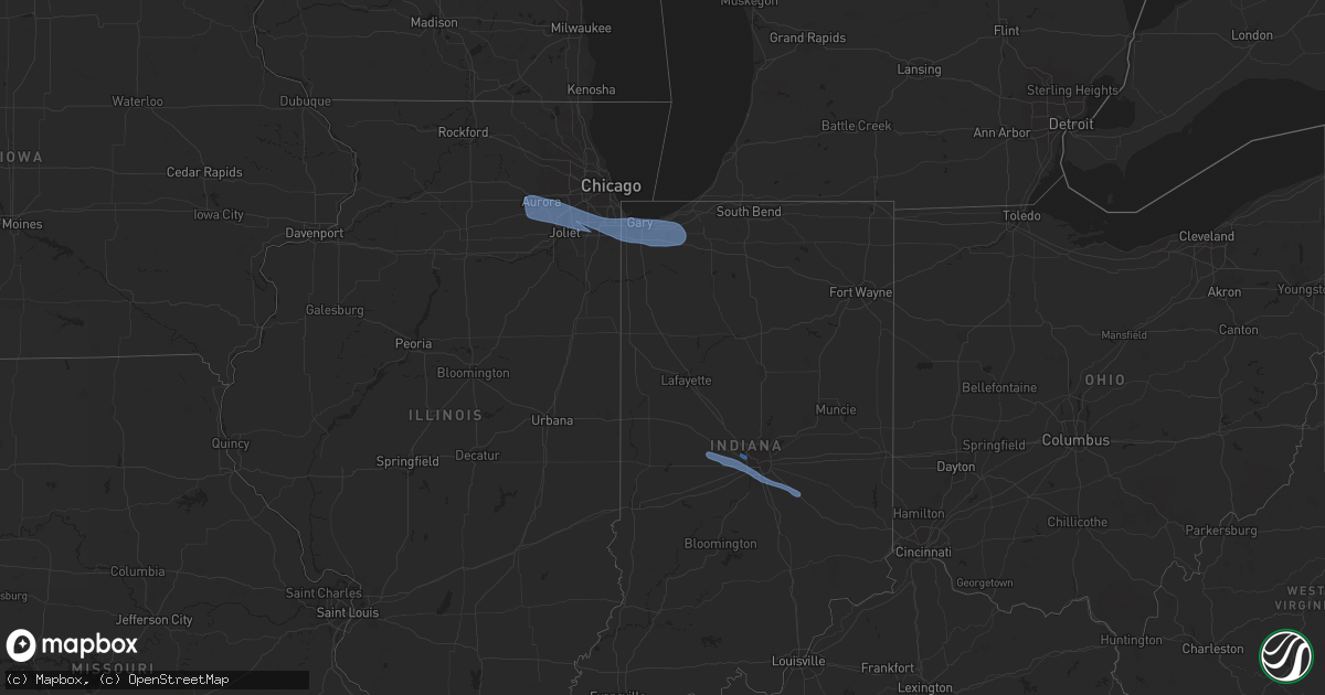
Hail Map in Indiana on March 25, 2022
Get this storm
March 25 map
$229
one time, instant access
Download today. No call, no setup
Keep the $229
Bought the map and want the full workflow? Apply the entire $229 to a subscription within 7 days. None of it is wasted.
Every map, not just this one
This buys you this map. Subscription and you get every map we run, in the markets you choose from a few cities to whole states to nationwide. Plus real-time alerts the moment a storm fires.
Contact data
Name, contact info, occupancy, even credit band for addresses in the footprint. You go from where it hit to who to call.
Become the source they trust
Unlimited branding weather history reports on demand. You already have the documented answer ready for the property owner, and you are the one who showed up with it.
Property data and RoofTrace estimates
Pull up any address you have got, its value and the exact code rules for that jurisdiction, straight from One Click Code. Then RoofTrace estimates the squares, pitch, and roof value, priced the way you price.
Storm reports in Indiana
Indiana
| Date | Description |
|---|---|
| 03/25/20226:20 PM CDT | Public reports large pine tree limbs down. Time estimated from radar. |
| 03/25/20225:42 PM CDT | Half inch galvanized steel pipe supporting a bird house blown over. |
| 03/25/20225:40 PM CDT | Downed power lines. |
| 03/25/20225:25 PM CDT | A local report indicates 60 MPH wind near GARY AIRPORT |
| 03/25/20225:25 PM CDT | Mesonet station xcav cline avenue bridge. |
| 03/25/20225:20 PM CDT | Fence damage. |
| 03/25/20224:41 AM CDT | At 941 PM EDT, a severe thunderstorm was located 8 miles northeast of Shelbyville, moving east at 40 mph. HAZARD...60 mph wind gusts. SOURCE...Radar indicated. IMPACT...Expect damage to roofs, siding, and trees. This severe thunderstorm will be near... Arlington around 945 PM EDT. Rushville and Moscow around 955 PM EDT. Milroy around 1000 PM EDT.Other locations in the path of this severe thunderstorm include NewSalem, Clarksburg and Lake Santee.This includes Interstate 74 between mile markers 114 and 124. |
| 03/25/20224:14 AM CDT | At 914 PM EDT, a severe thunderstorm was located over Greenwood, or 10 miles south of Indianapolis, moving east at 50 mph. HAZARD...60 mph wind gusts. SOURCE...Radar indicated. IMPACT...Expect damage to roofs, siding, and trees. This severe thunderstorm will be near... Franklin around 920 PM EDT. Fairland and Boggstown around 930 PM EDT.Other locations in the path of this severe thunderstorm includeShelbyville, St. Paul and Waldron.This includes the following highways... Interstate 65 between mile markers 90 and 103. Interstate 74 between mile markers 101 and 123. |
| 03/25/20223:51 AM CDT | At 851 PM EDT, a severe thunderstorm was located near Plainfield, or 13 miles west of Indianapolis, moving east at 50 mph. HAZARD...60 mph wind gusts. SOURCE...Radar indicated. IMPACT...Expect damage to roofs, siding, and trees. This severe thunderstorm will be near... Mooresville, Clermont and Eagle Creek Reservoir around 855 PM EDT. Speedway, Indianapolis Int'l Airport and Camby around 900 PM EDT. Monument Circle around 905 PM EDT. Beech Grove, Southport, Warren Park and Homecroft around 910 PM EDT.Other locations in the path of this severe thunderstorm includeGreenwood and Whiteland.This includes the following highways... Interstate 65 between mile markers 91 and 127. Interstate 70 between mile markers 63 and 87. Interstate 74 between mile markers 63 and 100. |
| 03/24/20228:04 PM CDT | Asos station keye indianapolis |
| 03/24/20227:59 PM CDT | Asos station kind indianapolis. |
| 03/24/20227:14 PM CDT | Awos station kokk kokomo. |
Cities Impacted by Hail Map on March 25, 2022
- Portage, IN
- Munster, IN
- Posen, IL
- Montgomery, IL
- Westville, IN
- Mokena, IL
- Merrillville, IN
- Frankfort, IL
- South Holland, IL
- Oswego, IL
- Markham, IL
- Calumet City, IL
- Saint John, IN
- Plano, IL
- Tinley Park, IL
- Olympia Fields, IL
- Palos Park, IL
- Robbins, IL
- Bolingbrook, IL
- Hebron, IN
- Chesterton, IN
- Glenwood, IL
- Yorkville, IL
- Oak Forest, IL
- Wanatah, IN
- Lake Station, IN
- Hobart, IN
- Aurora, IL
- Bristol, IL
- Crown Point, IN
- Romeoville, IL
- Country Club Hills, IL
- Dyer, IN
- Thornton, IL
- Dolton, IL
- Chicago Heights, IL
- Gary, IN
- Homer Glen, IL
- Sugar Grove, IL
- Lansing, IL
- Midlothian, IL
- Downers Grove, IL
- Plainfield, IL
- Orland Park, IL
- Lemont, IL
- Valparaiso, IN
- Homewood, IL
- Palos Heights, IL
- Flossmoor, IL
- Woodridge, IL
- Joliet, IL
- Highland, IN
- Schererville, IN
- Harvey, IL
- Hammond, IN
- Matteson, IL
- East Chicago, IN
- New Lenox, IL
- Crete, IL
- Lockport, IL
- Crestwood, IL
- Hazel Crest, IL
- Griffith, IN
- Crest Hill, IL
- Naperville, IL
- Blue Island, IL
- Needham, IN
- Plainfield, IN
- Shelbyville, IN
- Avon, IN
- Danville, IN
- Pittsboro, IN
- Greenwood, IN
- Brownsburg, IN
- North Salem, IN
- Lizton, IN
- Indianapolis, IN
- Fairland, IN
- Boggstown, IN


