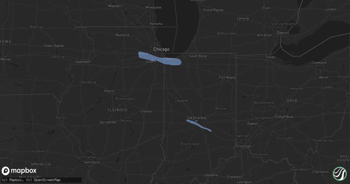
Hail Map in Illinois on March 25, 2022
Get this storm
March 25 map
$229
one time, instant access
Download today. No call, no setup
Keep the $229
Bought the map and want the full workflow? Apply the entire $229 to a subscription within 7 days. None of it is wasted.
Every map, not just this one
This buys you this map. Subscription and you get every map we run, in the markets you choose from a few cities to whole states to nationwide. Plus real-time alerts the moment a storm fires.
Contact data
Name, contact info, occupancy, even credit band for addresses in the footprint. You go from where it hit to who to call.
Become the source they trust
Unlimited branding weather history reports on demand. You already have the documented answer ready for the property owner, and you are the one who showed up with it.
Property data and RoofTrace estimates
Pull up any address you have got, its value and the exact code rules for that jurisdiction, straight from One Click Code. Then RoofTrace estimates the squares, pitch, and roof value, priced the way you price.
Storm reports in Illinois
Illinois
| Date | Description |
|---|---|
| 03/25/20224:51 PM CDT | Report of a roughly 1 foot diameter tree down in jefferson park. Time estimated based on radar. |
| 03/25/20224:45 PM CDT | Several two inch diameter tree limbs down. Hail also briefly covered the ground before melting. |
| 03/25/20224:40 PM CDT | Witnessed building materials flying through air at lewis university airport. |
| 03/25/20224:23 PM CDT | Roof damage to an industrial building with debris on roadway. |
| 03/25/20224:20 PM CDT | Report of power lines down across us 34 at tuma road... Blocking portions of the road. |
| 03/25/20224:20 PM CDT | Westbound van emmon road blocked near benjamin street due to a downed tree. Time estimated based on radar. |
| 03/25/20224:18 PM CDT | Corrects previous non-tstm wnd gst report from 2 w sugar grove. Asos station karr sugar grove - aurora arpt. |
| 03/25/202212:20 AM CDT | At 520 PM CDT, a severe thunderstorm was located near Gary, moving east at 50 mph. HAZARD...65 to 70 mph wind gusts. SOURCE...Radar indicated. IMPACT...Expect considerable tree damage. Damage is likely to mobile homes, roofs, and outbuildings. Locations impacted include... Hammond, Gary, Portage, Merrillville, Valparaiso, East Chicago, Schererville, Hobart, Lansing, Crown Point, Highland, Munster, Chesterton, Griffith, Dyer, St. John, Lake Station, Lynwood, South Haven and Whiting.Including the following interstates... Indiana I-80 between mile markers 1 and 16. Indiana I-90 between mile markers 3 and 37. Indiana I-94 between mile markers 16 and 32. Indiana I-65 between mile markers 251 and 261.This includes... Indiana University Northwest, Purdue UniversityNorthwest Hammond, Valparaiso University, Illiana Motor Speedway,Indiana Dunes State Park, Porter County Fairgrounds, and South ShoreRail Cats Baseball. |
| 03/24/202211:44 PM CDT | At 444 PM CDT, a severe thunderstorm was located over Lemont, moving east at 50 mph. HAZARD...70 mph wind gusts. SOURCE...Radar indicated. IMPACT...Expect considerable tree damage. Damage is likely to mobile homes, roofs, and outbuildings. Locations impacted include... Chicago, Orland Park, Tinley Park, Oak Lawn, Calumet City, Chicago Heights, Roseland, South Shore, Chicago Lawn, Burbank, Lansing, Oak Forest, Harvey, Homer Glen, Blue Island, Dolton, Park Forest, Homewood, Alsip and Matteson.Including the following interstates... I-55 between mile markers 277 and 280. I-57 between mile markers 338 and 358. I-80 between mile markers 143 and 155. I-90 between mile markers 104 and 107. I-94 between mile markers 61 and 74. I-294 between mile markers 61 and 74. I-355 between mile markers 8 and 10.This includes... Windy City Thunderbolts Baseball, Hollywood CasinoAmphitheatre, Moraine Valley Community College, Prairie StateCollege, and South Suburban College. |
| 03/24/202211:16 PM CDT | At 416 PM CDT, a severe thunderstorm was located over Sugar Grove, or near Oswego, moving east at 50 mph. HAZARD...70 mph wind gusts. SOURCE...Automated observations. A gust 63 mph wind gust was measured in Sugar Grove. IMPACT...Expect considerable tree damage. Damage is likely to mobile homes, roofs, and outbuildings. Locations impacted include... Aurora, Joliet, Naperville, Bolingbrook, Downers Grove, Romeoville, Plainfield, Woodridge, Oswego, Batavia, Lockport, New Lenox, Homer Glen, Mokena, Yorkville, Lemont, Plano, Burr Ridge, Westmont and Lisle.Including the following interstates... I-55 between mile markers 256 and 276. I-80 between mile markers 137 and 142. I-88 between mile markers 105 and 125. I-355 between mile markers 1 and 7, and between mile markers 11 and18.This includes... Argonne National Laboratory, Aurora University,Benedictine University, IL Math and Science Academy, LewisUniversity, Waubonsee Community College, and North Central College. |
Cities Impacted by Hail Map on March 25, 2022
- Portage, IN
- Munster, IN
- Posen, IL
- Montgomery, IL
- Westville, IN
- Mokena, IL
- Merrillville, IN
- Frankfort, IL
- South Holland, IL
- Oswego, IL
- Markham, IL
- Calumet City, IL
- Saint John, IN
- Plano, IL
- Tinley Park, IL
- Olympia Fields, IL
- Palos Park, IL
- Robbins, IL
- Bolingbrook, IL
- Hebron, IN
- Chesterton, IN
- Glenwood, IL
- Yorkville, IL
- Oak Forest, IL
- Wanatah, IN
- Lake Station, IN
- Hobart, IN
- Aurora, IL
- Bristol, IL
- Crown Point, IN
- Romeoville, IL
- Country Club Hills, IL
- Dyer, IN
- Thornton, IL
- Dolton, IL
- Chicago Heights, IL
- Gary, IN
- Homer Glen, IL
- Sugar Grove, IL
- Lansing, IL
- Midlothian, IL
- Downers Grove, IL
- Plainfield, IL
- Orland Park, IL
- Lemont, IL
- Valparaiso, IN
- Homewood, IL
- Palos Heights, IL
- Flossmoor, IL
- Woodridge, IL
- Joliet, IL
- Highland, IN
- Schererville, IN
- Harvey, IL
- Hammond, IN
- Matteson, IL
- East Chicago, IN
- New Lenox, IL
- Crete, IL
- Lockport, IL
- Crestwood, IL
- Hazel Crest, IL
- Griffith, IN
- Crest Hill, IL
- Naperville, IL
- Blue Island, IL
- Needham, IN
- Plainfield, IN
- Shelbyville, IN
- Avon, IN
- Danville, IN
- Pittsboro, IN
- Greenwood, IN
- Brownsburg, IN
- North Salem, IN
- Lizton, IN
- Indianapolis, IN
- Fairland, IN
- Boggstown, IN


