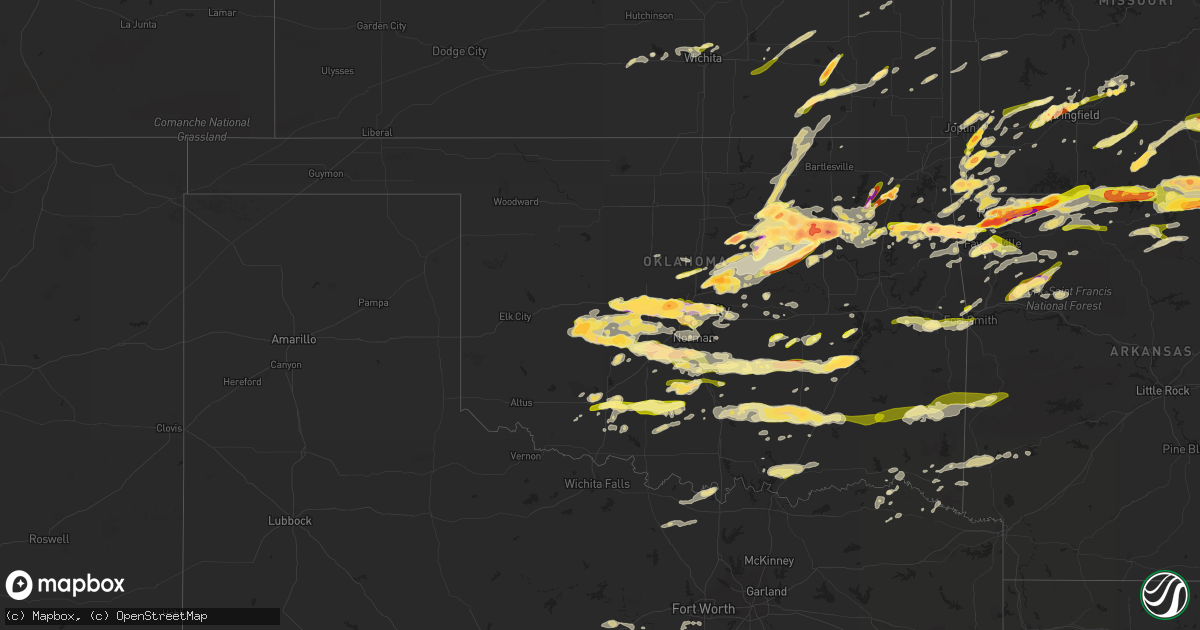
Hail Map in Oklahoma on March 25, 2015
Get this storm
March 25 map
$229
one time, instant access
Download today. No call, no setup
Keep the $229
Bought the map and want the full workflow? Apply the entire $229 to a subscription within 7 days. None of it is wasted.
Every map, not just this one
This buys you this map. Subscription and you get every map we run, in the markets you choose from a few cities to whole states to nationwide. Plus real-time alerts the moment a storm fires.
Contact data
Name, contact info, occupancy, even credit band for addresses in the footprint. You go from where it hit to who to call.
Become the source they trust
Unlimited branding weather history reports on demand. You already have the documented answer ready for the property owner, and you are the one who showed up with it.
Property data and RoofTrace estimates
Pull up any address you have got, its value and the exact code rules for that jurisdiction, straight from One Click Code. Then RoofTrace estimates the squares, pitch, and roof value, priced the way you price.
Storm reports in Oklahoma
Oklahoma
| Date | Description |
|---|---|
| 03/25/20156:56 PM CDT | A local report indicates a tornado near INOLA |
| 03/25/20156:55 PM CDT | A local report indicates 1.00 inch wind near 7 NNW CHICKASHA |
| 03/25/20156:55 PM CDT | Large tree limbs blow over a rural road. |
| 03/25/20156:53 PM CDT | A local report indicates 72 MPH wind near WILL ROGERS AIRPORT |
| 03/25/20156:45 PM CDT | A local report indicates 60 MPH wind near 5 NNW CHICKASHA |
| 03/25/20156:42 PM CDT | Nickel to quarter |
| 03/25/20156:41 PM CDT | Made holes in convertible car top |
| 03/25/20156:35 PM CDT | Began 635pm near sw119/penn ended 646pm near se34/sunnylane... Time and location est from radar. |
| 03/25/20156:35 PM CDT | Several large tree limbs broken. One tree over a road. |
| 03/25/20156:35 PM CDT | A local report indicates 1.00 inch wind near WARR ACRES |
| 03/25/20156:35 PM CDT | A local report indicates 1.75 inch wind near ADAIR |
| 03/25/20156:33 PM CDT | Windowns blown out of homes. |
| 03/25/20156:33 PM CDT | A local report indicates 59 MPH wind near WILL ROGERS AIRPORT |
| 03/25/20156:32 PM CDT | A local report indicates 60 MPH wind near WILEY POST AIRPORT |
| 03/25/20156:31 PM CDT | A local report indicates 1.00 inch wind near 3 N WARWICK |
| 03/25/20156:30 PM CDT | 21st and yale. |
| 03/25/20156:30 PM CDT | Glass door shattered on 1st floor of building housing wfo tulsa. |
| 03/25/20156:29 PM CDT | Reported at admiral and sheridan. |
| 03/25/20156:28 PM CDT | A local report indicates 1.00 inch wind near CATOOSA |
| 03/25/20156:28 PM CDT | A local report indicates 1.75 inch wind near 1 E LOCUST GROVE |
| 03/25/20156:27 PM CDT | A local report indicates 1.00 inch wind near MUSTANG |
| 03/25/20156:27 PM CDT | Tennis ball sized hail reported at interstate 40 and morgan road. |
| 03/25/20156:27 PM CDT | A local report indicates 1.75 inch wind near YUKON |
| 03/25/20156:26 PM CDT | Inflow winds reported at 145th e. Ave and the broken arrow expressway. |
| 03/25/20156:26 PM CDT | Spotter report of 80-100 mph inflow winds. |
| 03/25/20156:25 PM CDT | Tree damage. One tree partially over a rural road. |
| 03/25/20156:24 PM CDT | Cause considerable damage to autos. |
| 03/25/20156:22 PM CDT | A local report indicates 1.00 inch wind near 3 S MUSTANG |
| 03/25/20156:22 PM CDT | A local report indicates 73 MPH wind near 3 S MUSTANG |
| 03/25/20156:22 PM CDT | A local report indicates 1.75 inch wind near 4 W GRACEMONT |
| 03/25/20156:19 PM CDT | In downtown tulsa. |
| 03/25/20156:18 PM CDT | At 161st e. Ave and i-44. |
| 03/25/20156:18 PM CDT | A local report indicates 1.50 inch wind near 6 SW YUKON |
| 03/25/20156:17 PM CDT | A local report indicates 1.00 inch wind near 4 SW BETHANY |
| 03/25/20156:15 PM CDT | Golf ball size hail at berryville. |
| 03/25/20156:15 PM CDT | A local report indicates 1.00 inch wind near 2 W LUTHER |
| 03/25/20156:15 PM CDT | Estimated 60-70 mph winds at admiral and sheridan. |
| 03/25/20156:15 PM CDT | Report of roofs blown off homes in 15th and harvard area. |
| 03/25/20156:13 PM CDT | Powerlines down at admiral and sheridan. |
| 03/25/20156:12 PM CDT | Softball hail at cahndler park. |
| 03/25/20156:12 PM CDT | An anticyclonic tornado was observed north of southwest 15th street and gregory road. No damage is known to have occurred. |
| 03/25/20156:11 PM CDT | Reported at apache and sheridan. |
| 03/25/20156:10 PM CDT | Large wooden swingset blown over. Near 31st street and 193rd east ave. |
| 03/25/20156:09 PM CDT | A local report indicates 1.25 inch wind near EL RENO |
| 03/25/20156:08 PM CDT | A local report indicates 1.75 inch wind near EL RENO |
| 03/25/20156:07 PM CDT | Near berryhill. |
| 03/25/20156:05 PM CDT | A local report indicates 3.00 inch wind near SAND SPRINGS |
| 03/25/20156:05 PM CDT | A local report indicates 1.25 inch wind near FOYIL |
| 03/25/20156:05 PM CDT | Tree down near 66th north and 129th east. |
| 03/25/20156:02 PM CDT | Ef-0 damage found near mingo/admiral with a short tornado path length. |
| 03/25/20156:00 PM CDT | A local report indicates 60 MPH wind near 4 NNW FORT COBB |
| 03/25/20156:00 PM CDT | A local report indicates 2.00 inch wind near 4 SW EL RENO |
| 03/25/20156:00 PM CDT | A local report indicates 2.00 inch wind near 1 W SAND SPRINGS |
| 03/25/20155:58 PM CDT | A local report indicates 1.50 inch wind near MANNFORD |
| 03/25/20155:57 PM CDT | At i-35 and highway 77 |
| 03/25/20155:57 PM CDT | Reported at 71st street and peoria. |
| 03/25/20155:53 PM CDT | A local report indicates 1.00 inch wind near SAND SPRINGS |
| 03/25/20155:51 PM CDT | A local report indicates 1.75 inch wind near 4 N LUTHER |
| 03/25/20155:50 PM CDT | Bears glen exit off u.s. 412 near lake keystone. |
| 03/25/20155:45 PM CDT | Numerous reports of trees and power poles down on the northern side of the city of tulsa between 545 pm and 700 pm. Most of these reports were north of 21st street from |
| 03/25/20155:45 PM CDT | Numerous reports of quarter to golf balll sized hail in the city of tulsa...mainly north of 21st street. |
| 03/25/20155:40 PM CDT | At i-40 and route 81 |
| 03/25/20155:40 PM CDT | Charter oak road between penn and western. |
| 03/25/20155:38 PM CDT | Donut shop destroyed at highway 97. |
| 03/25/20155:34 PM CDT | *** 1 fatal *** extensive damage in mobile home park near highway 51 and 145 west avenue. |
| 03/25/20155:30 PM CDT | A local report indicates 2.50 inch wind near 4 SE WESTPORT |
| 03/25/20155:30 PM CDT | A local report indicates 80 MPH wind near 4 SE WESTPORT |
| 03/25/20155:30 PM CDT | 2 inch hail at prue. |
| 03/25/20155:29 PM CDT | Relayed by kfor |
| 03/25/20155:25 PM CDT | Largest was golf ball size. Minor wind damage to a few signs and two trampolines overturned. |
| 03/25/20155:15 PM CDT | A local report indicates 1.75 inch wind near COLONY |
| 03/25/20155:15 PM CDT | Large limbs down. |
| 03/25/20155:00 PM CDT | A local report indicates 1.75 inch wind near CLEVELAND |
| 03/25/20154:57 PM CDT | A local report indicates 2.00 inch wind near 5 E STILLWATER |
| 03/25/20154:57 PM CDT | Reported at intersection of highway 64 and 99. |
| 03/25/20154:55 PM CDT | A local report indicates 1.75 inch wind near 4 E STILLWATER |
| 03/25/20154:55 PM CDT | Southeast part of stillwater... Tweet relayed by kwtv |
| 03/25/20154:53 PM CDT | Reported at i-44 and arkansas river. |
| 03/25/20154:50 PM CDT | Relayed via twitter by koco |
| 03/25/20154:50 PM CDT | A local report indicates 1.25 inch wind near 4 SE SAND SPRINGS |
| 03/25/20154:50 PM CDT | Relayed by koco-tv. |
| 03/25/20154:48 PM CDT | Nickel to quarter hail |
| 03/25/20154:43 PM CDT | A local report indicates 1.00 inch wind near 6 SW TULSA |
| 03/25/20154:41 PM CDT | A local report indicates 1.75 inch wind near JENNINGS |
| 03/25/20154:41 PM CDT | A local report indicates 1.75 inch wind near SAPULPA |
| 03/25/20154:25 PM CDT | West of sapulpa on state highway 33. |
| 03/25/20154:19 PM CDT | A local report indicates 1.00 inch wind near 1 W KELLYVILLE |
| 03/25/20154:19 PM CDT | A local report indicates 1.00 inch wind near 3 W MARAMEC |
| 03/25/20154:00 PM CDT | A local report indicates 1.50 inch wind near BRISTOW |
| 03/25/20153:55 PM CDT | A local report indicates 1.00 inch wind near WATTS |
| 03/25/20153:52 PM CDT | Nickel to quarter size hail...per video. |
| 03/25/20153:40 PM CDT | Reported by cushing eoc |
| 03/25/20153:33 PM CDT | A local report indicates 1.00 inch wind near 3 N STROUD |
| 03/25/20153:27 PM CDT | Nickel to quarter size hail covering u.s. Highway 62. |
| 03/25/20153:05 PM CDT | A local report indicates 1.00 inch wind near ROLAND |
| 03/25/201512:15 AM CDT | A local report indicates 60 MPH wind near BOKCHITO |
| 03/24/201511:51 PM CDT | A local report indicates 1.00 inch wind near DURANT |
| 03/24/201511:43 PM CDT | Several large tree limbs and branches blown down. |
| 03/24/201510:54 PM CDT | On route 3 |
| 03/24/201510:46 PM CDT | A local report indicates 1.00 inch wind near WAPANUCKA |
| 03/24/201510:28 PM CDT | A local report indicates 1.00 inch wind near POCOLA |
| 03/24/201510:28 PM CDT | North side of town. |
| 03/24/201510:12 PM CDT | Near kerr dam. |
| 03/24/201510:10 PM CDT | A local report indicates 63 MPH wind near 6 SW FITTSTOWN |
| 03/24/201510:05 PM CDT | A local report indicates 66 MPH wind near 6 SW FITTSTOWN |
| 03/24/20159:59 PM CDT | A local report indicates 1.00 inch wind near 5 W EUFAULA |
| 03/24/20159:46 PM CDT | A local report indicates 1.00 inch wind near CALVIN |
| 03/24/20159:15 PM CDT | A local report indicates 1.00 inch wind near 6 ENE WETUMKA |
| 03/24/20159:15 PM CDT | A local report indicates 1.00 inch wind near 3 SW VELMA |
| 03/24/20159:13 PM CDT | A local report indicates 1.00 inch wind near KONAWA |
| 03/24/20159:09 PM CDT | A local report indicates 60 MPH wind near TATUMS |
| 03/24/20158:50 PM CDT | Large tree limbs down. |
| 03/24/20158:37 PM CDT | A local report indicates 1.00 inch wind near WANETTE |
| 03/24/20158:36 PM CDT | A local report indicates 1.00 inch wind near 5 E DUNCAN |
| 03/24/20158:32 PM CDT | A local report indicates 1.00 inch wind near DUNCAN |
| 03/24/20158:15 PM CDT | A local report indicates 2.50 inch wind near WATTS |
| 03/24/20158:09 PM CDT | Barn roof blown off. Hwy 9 and 366 |
| 03/24/20158:09 PM CDT | Two inch diameter tree limbs blown down by thunderstorm winds. |
| 03/24/20158:08 PM CDT | Trees and limbs down north of boley. |
| 03/24/20158:07 PM CDT | A local report indicates 1.25 inch wind near LINDSAY |
| 03/24/20158:05 PM CDT | A local report indicates 1.75 inch wind near 4 W WEST SILOAM SPRINGS |
| 03/24/20158:00 PM CDT | A local report indicates 1.00 inch wind near 3 ESE LAWTON |
| 03/24/20157:58 PM CDT | A local report indicates 2.50 inch wind near KANSAS |
| 03/24/20157:58 PM CDT | A local report indicates 1.00 inch wind near 4 E LAWTON |
| 03/24/20157:57 PM CDT | Golf ball hail near chewey. |
| 03/24/20157:55 PM CDT | A local report indicates 1.50 inch wind near OAKS |
| 03/24/20157:53 PM CDT | Reported at lawton airport |
| 03/24/20157:50 PM CDT | A local report indicates 1.00 inch wind near PURCELL |
| 03/24/20157:49 PM CDT | A local report indicates 1.00 inch wind near 1 NE WASHINGTON |
| 03/24/20157:40 PM CDT | A local report indicates 1.25 inch wind near LAWTON |
| 03/24/20157:29 PM CDT | A local report indicates 1.00 inch wind near MIDDLEBERG |
| 03/24/20157:25 PM CDT | A local report indicates 1.75 inch wind near LOCUST GROVE |
| 03/24/20157:25 PM CDT | Two power poles and some trees down. |
| 03/24/20157:25 PM CDT | Probable tornado. 26 trees blown down...several buildings damaged. Shingles off a roof. Sycamore springs ranch. |
| 03/24/20157:23 PM CDT | Fences blown down |
| 03/24/20157:15 PM CDT | A local report indicates 1.00 inch wind near SPARKS |
| 03/24/20157:10 PM CDT | A local report indicates 1.00 inch wind near CHICKASHA |
| 03/24/20157:09 PM CDT | A local report indicates 1.00 inch wind near CHICKASHA |
| 03/24/20157:07 PM CDT | A local report indicates 65 MPH wind near 4 S CHOCTAW |
| 03/24/20157:07 PM CDT | A local report indicates 1.25 inch wind near 4 S CHOCTAW |
| 03/24/20157:06 PM CDT | A local report indicates 1.50 inch wind near 4 S COLCORD |
| 03/24/20157:02 PM CDT | A local report indicates 1.25 inch wind near TINKER AIR FORCE BASE |
All States Impacted by Hail Map on March 25, 2015
Cities Impacted by Hail Map on March 25, 2015
- Caulfield, MO
- West Plains, MO
- Moody, MO
- Neosho, MO
- Union City, OK
- Yukon, OK
- Calumet, OK
- Oklahoma City, OK
- El Reno, OK
- Bethany, OK
- Mustang, OK
- Bristow, OK
- Stroud, OK
- Depew, OK
- Claremore, OK
- Broken Arrow, OK
- Blossom, TX
- Paris, TX
- Lowell, AR
- Springdale, AR
- Rogers, AR
- Cave Springs, AR
- Gordon, TX
- Thebes, IL
- Jonesboro, IL
- Tamms, IL
- Golconda, IL
- Grand Chain, IL
- Stonefort, IL
- Buncombe, IL
- Belknap, IL
- Vienna, IL
- Whitewater, MO
- Simpson, IL
- Scott City, MO
- Karnak, IL
- Anna, IL
- Dongola, IL
- Burfordville, MO
- Alto Pass, IL
- Wolf Lake, IL
- Cape Girardeau, MO
- McClure, IL
- Cypress, IL
- Marble Hill, MO
- Chaffee, MO
- Eddyville, IL
- Jackson, MO
- Grantsburg, IL
- Leopold, MO
- Ullin, IL
- Cobden, IL
- Konawa, OK
- Bokchito, OK
- Bennington, OK
- Durant, OK
- Kingston, OK
- Caddo, OK
- Mead, OK
- Calera, OK
- Madill, OK
- Rochelle, TX
- Mannford, OK
- Sand Springs, OK
- Tulsa, OK
- Catoosa, OK
- Sperry, OK
- Owasso, OK
- Elkins, AR
- Anadarko, OK
- Lookeba, OK
- Gracemont, OK
- Binger, OK
- Wanette, OK
- Calvin, OK
- Lexington, OK
- Byars, OK
- Wewoka, OK
- Asher, OK
- Holdenville, OK
- Ada, OK
- Sasakwa, OK
- Atwood, OK
- Cushing, OK
- Pawnee, OK
- Terlton, OK
- Prue, OK
- Sapulpa, OK
- Yale, OK
- Hominy, OK
- Stillwater, OK
- Fairfax, OK
- Glencoe, OK
- Skiatook, OK
- Osage, OK
- Drumright, OK
- Jennings, OK
- Cleveland, OK
- Maramec, OK
- Ripley, OK
- Kellyville, OK
- Walters, OK
- Niangua, MO
- Purcell, OK
- Washington, OK
- Berryville, AR
- Green Forest, AR
- Snow, OK
- Wichita, KS
- Kechi, KS
- Palo Pinto, TX
- Strawn, TX
- Santo, TX
- Lipan, TX
- Cheney, KS
- Bentonville, AR
- Gentry, AR
- Garfield, AR
- Eureka Springs, AR
- Guthrie, OK
- Edmond, OK
- Marmaduke, AR
- Harrison, AR
- Sulphur, OK
- Davis, OK
- Elk City, KS
- Sedan, KS
- Elk Falls, KS
- Longton, KS
- Fredonia, KS
- Neodesha, KS
- Inola, OK
- Atoka, OK
- Wapanucka, OK
- Lawton, OK
- Geronimo, OK
- Republic, MO
- Bois D Arc, MO
- Springfield, MO
- Montague, TX
- Forestburg, TX
- Muenster, TX
- Saint Jo, TX
- Sunset, TX
- Bowie, TX
- Oak Grove, AR
- Oldfield, MO
- Seymour, MO
- Chadwick, MO
- Mansfield, MO
- Ava, MO
- Duncan, OK
- Marlow, OK
- Foster, OK
- Carnegie, OK
- Lindsay, OK
- Gainesville, TX
- Elmore City, OK
- Elgin, OK
- Minco, OK
- Hinton, OK
- Seminole, OK
- Sparta, MO
- Fair Grove, MO
- Benton, KS
- Granby, MO
- Carthage, MO
- Sarcoxie, MO
- Diamond, MO
- Alex, OK
- Blanchard, OK
- Chickasha, OK
- Amber, OK
- Verden, OK
- Pocasset, OK
- Luther, OK
- Wellston, OK
- Arcadia, OK
- Carney, OK
- Chandler, OK
- Meridian, OK
- Dolph, AR
- Calico Rock, AR
- Norfork, AR
- Tahlequah, OK
- Rose, OK
- Kansas, OK
- Colcord, OK
- Twin Oaks, OK
- Oaks, OK
- Pineville, MO
- Seligman, MO
- Walnut Grove, MO
- Ash Grove, MO
- Everton, MO
- Mcloud, OK
- Shawnee, OK
- Gainesville, MO
- Mountain Home, AR
- Peel, AR
- Protem, MO
- Cedarcreek, MO
- Lead Hill, AR
- Oakland, AR
- Isabella, MO
- Pontiac, MO
- Theodosia, MO
- Yellville, AR
- Kirbyville, MO
- Clarkridge, AR
- Dierks, AR
- Nashville, AR
- Mena, AR
- Dustin, OK
- Wetumka, OK
- Honobia, OK
- Ozark, MO
- Tryon, OK
- Perkins, OK
- Fort Cobb, OK
- Big Cabin, OK
- Adair, OK
- Chelsea, OK
- Eminence, MO
- Ozone, AR
- Clarksville, AR
- Glenallen, MO
- Uniontown, KY
- Morganfield, KY
- Goodman, MO
- Prairie Grove, AR
- Fayetteville, AR
- Farmington, AR
- Lincoln, AR
- Willow Springs, MO
- Cabool, MO
- Elk Creek, MO
- Coalgate, OK
- Hydro, OK
- Colony, OK
- Cordell, OK
- Siloam Springs, AR
- Fort Smith, AR
- Pocola, OK
- Spiro, OK
- Arkoma, OK
- Gans, OK
- Sallisaw, OK
- Keota, OK
- Muldrow, OK
- Waverly, KY
- Corydon, KY
- Henderson, KY
- Maysville, OK
- Wayne, OK
- Ellsinore, MO
- Comanche, OK
- Galesburg, KS
- Thayer, KS
- Chanute, KS
- Watts, OK
- Summersville, MO
- Yukon, MO
- Birch Tree, MO
- Sheldon, MO
- Marshfield, MO
- Willard, MO
- Clarksville, TX
- Westville, OK
- Collinsville, OK
- Tishomingo, OK
- Stonewall, OK
- Centrahoma, OK
- Mill Creek, OK
- Tupelo, OK
- Roff, OK
- Wynnewood, OK
- Stringtown, OK
- Norwood, MO
- Drury, MO
- Virgil, KS
- Eureka, KS
- Hamilton, KS
- Piedmont, KS
- Leon, KS
- Silva, MO
- Mountain View, MO
- Wasola, MO
- Noble, MO
- Washburn, MO
- Noel, MO
- Anderson, MO
- Grove, OK
- Lanagan, MO
- Sulphur Springs, AR
- Rocky Comfort, MO
- Bella Vista, AR
- Gravette, AR
- Maysville, AR
- Jay, OK
- South West City, MO
- Centerton, AR
- Pea Ridge, AR
- Powell, MO
- Stark City, MO
- Locust Grove, OK
- Rush Springs, OK
- Pauls Valley, OK
- Fort Sill, OK
- Van Buren, MO
- Gepp, AR
- Viola, AR
- Detroit, TX
- Thayer, MO
- Koshkonong, MO
- Chouteau, OK
- Marquand, MO
- Clubb, MO
- Greenville, MO
- Pulaski, IL
- Lodi, MO
- Patterson, MO
- Lowndes, MO
- Fredericktown, MO
- Advance, MO
- Olmsted, IL
- Gipsy, MO
- Zalma, MO
- Strafford, MO
- Henderson, AR
- Elizabeth, AR
- Andale, KS
- Maize, KS
- Colwich, KS
- Goddard, KS
- Valley Center, KS
- Clever, MO
- Nixa, MO
- Fall River, KS
- Reeds, MO
- Smithville, OK
- Girard, KS
- Stratford, OK
- Thornfield, MO
- Oologah, OK
- Flippin, AR
- Council Hill, OK
- Norman, OK
- Joplin, MO
- Carterville, MO
- Webb City, MO
- Kingman, KS
- Camp, AR
- Salem, AR
- Tecumseh, MO
- Sturkie, AR
- Mammoth Spring, AR
- Pottersville, MO
- Bakersfield, MO
- Glenpool, OK
- Mounds, OK
- Bixby, OK
- Kiefer, OK
- Jenks, OK
- Mcalester, OK
- Stuart, OK
- Ozark, AR
- Oark, AR
- Brookesmith, TX
- El Dorado Springs, MO
- Milo, MO
- Winslow, AR
- Combs, AR
- Witter, AR
- Huntsville, AR
- Conway, MO
- Noble, OK
- Choctaw, OK
- Wheatland, OK
- Corn, OK
- Newalla, OK
- Tuttle, OK
- Geary, OK
- Harrah, OK
- Spencer, OK
- Coleman, OK
- Richland Springs, TX
- Wynona, OK
- Chautauqua, KS
- Niotaze, KS
- Pryor, OK
- Agra, OK
- Havana, KS
- Peru, KS
- Coweta, OK
- Pawhuska, OK
- Davenport, OK
- Mount Vernon, MO
- Billings, MO
- Marionville, MO
- Erie, KS
- Pierce City, MO
- Wentworth, MO
- Aurora, MO
- Cache, OK
- Indiahoma, OK
- Nashoba, OK
- Eagletown, OK
- Broken Bow, OK
- Van Buren, AR
- Peggs, OK
- Idabel, OK
- Zephyr, TX
- Early, TX
- Brownwood, TX
- Pettigrew, AR
- Mulberry, AR
- Deer, AR
- Sawyer, OK
- Fort Towson, OK
- Hindsville, AR
- Purdy, MO
- Verona, MO
- Monett, MO
- Parthenon, AR
- Jasper, AR
- Omaha, AR
- Alpena, AR
- Ridgedale, MO
- Hollister, MO
- Crescent, OK
- Gillham, AR
- Lockesburg, AR
- De Queen, AR
- Boley, OK
- Castle, OK
- Okemah, OK
- Bethel, OK
- Rudy, AR
- Bagwell, TX
- Rosalia, KS
- Salina, OK
- Elkland, MO
- Allen, OK
- Eufaula, OK
- Hanna, OK
- Squires, MO
- San Saba, TX
- Goldthwaite, TX
- Fort Worth, TX
- Crowley, TX
- Meeker, OK
- Proctor, OK
- McCune, KS
- Mountain Grove, MO
- Vanzant, MO
- Shawneetown, IL
- Newcastle, OK
- West Fork, AR
- Prague, OK
- Paden, OK
- Des Arc, MO
- Stigler, OK
- Porum, OK
- Roland, OK
- Winona, MO
- Salem, MO
- Eunice, MO
- Gamaliel, AR
- Fairview, MO
- Ellington, MO
- Arma, KS
- Avilla, MO
- Grovespring, MO
- Wheaton, MO
- Uniontown, KS
- Fort Scott, KS
- Hepler, KS
- Ramona, OK
- Talala, OK
- Vera, OK
- Pleasant Hope, MO
- Spavinaw, OK
- Eucha, OK
- Brandsville, MO
- Glencoe, AR
- Tussy, OK
- Hennepin, OK
- Beggs, OK
- Summers, AR
- Hulbert, OK
- Dora, MO
- Udall, MO
- Couch, MO
- Liberal, MO
- Mindenmines, MO
- Chester, AR
- Gassville, AR
- Stotts City, MO
- Garden Plain, KS
- Sturgis, KY
- Mullin, TX
- Elizabethtown, IL
- Junction, IL
- Equality, IL
- Herod, IL
- Copan, OK
- Wann, OK
- Checotah, OK
- Hagarville, AR
- Chattanooga, OK
- Loveland, OK
- Valliant, OK
- Stilwell, OK
- Brighton, MO
- Welda, KS
- Colony, KS
- Pyatt, AR
- Hennessey, OK
- Lamar, OK
- Pittsburg, OK
- Daisy, OK
- Fitzhugh, OK
- Parsons, KS
- Harriet, AR
- Big Flat, AR
- Hodgen, OK
- Haworth, OK
- Winthrop, AR
- Stella, MO
- Miller, MO
- La Russell, MO
- Murdock, KS
- Ponca, AR
- Kingston, AR
- Murfreesboro, AR
- Jerico Springs, MO
- Neosho Falls, KS
- Le Roy, KS
- Cedar Vale, KS
- Wesley, AR
- Exeter, MO
- Hiwasse, AR
- Seneca, MO
- Ninnekah, OK
- Sparks, OK
- Piedmont, MO
- Vinita, OK
- Mill Spring, MO
- Faxon, OK
- Blue Eye, MO
- Everton, AR
- Houston, MO
- South Greenfield, MO
- Paoli, OK
- Bradley, OK
- Antlers, OK
- Clayton, OK
- Makanda, IL
- Atlanta, KS
- Latham, KS
- Whitesboro, OK
- Rattan, OK
- Muse, OK
- Heavener, OK


