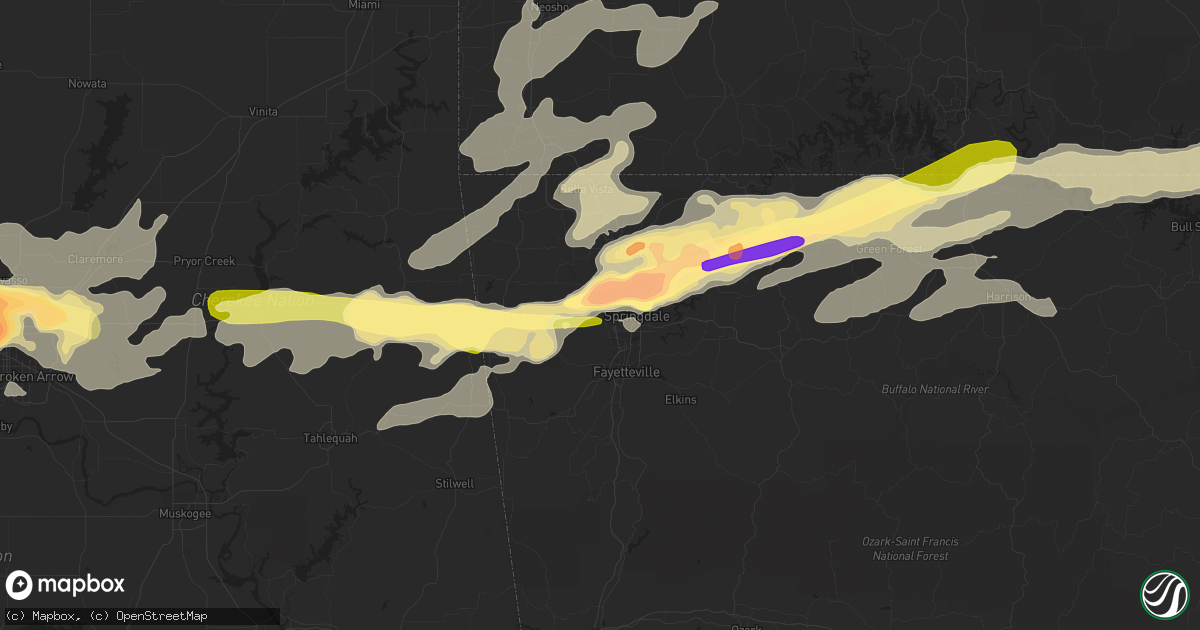
Hail Map in Springdale, AR on March 25, 2015
Get this storm
March 25 map
$229
one time, instant access
Download today. No call, no setup
Keep the $229
Bought the map and want the full workflow? Apply the entire $229 to a subscription within 7 days. None of it is wasted.
Every map, not just this one
This buys you this map. Subscription and you get every map we run, in the markets you choose from a few cities to whole states to nationwide. Plus real-time alerts the moment a storm fires.
Contact data
Name, contact info, occupancy, even credit band for addresses in the footprint. You go from where it hit to who to call.
Become the source they trust
Unlimited branding weather history reports on demand. You already have the documented answer ready for the property owner, and you are the one who showed up with it.
Property data and RoofTrace estimates
Pull up any address you have got, its value and the exact code rules for that jurisdiction, straight from One Click Code. Then RoofTrace estimates the squares, pitch, and roof value, priced the way you price.
Storm reports in Springdale, AR
Springdale, AR
| Date | Description |
|---|---|
| 03/25/20156:21 PM CDT | Golf ball to baseball hail. |
| 03/25/20154:58 PM CDT | Reports of trees uprooted in bethel heights. |
| 03/25/20154:50 PM CDT | Trees snapped and uprooted at bethel heights. |
| 03/25/20154:50 PM CDT | 1.5 inch hail in bethel heights. |
| 03/25/20154:41 PM CDT | A local report indicates 1.00 inch wind near 1 E ELM SPRINGS |
| 03/25/20154:35 PM CDT | A local report indicates 1.50 inch wind near ELM SPRINGS |
| 03/24/20158:25 PM CDT | A local report indicates 1.00 inch wind near TONTITOWN |
All States Impacted by Hail Map on March 25, 2015
All Cities Impacted by Hail Map on March 25, 2015
- Caulfield, MO
- West Plains, MO
- Moody, MO
- Neosho, MO
- Union City, OK
- Yukon, OK
- Calumet, OK
- Oklahoma City, OK
- El Reno, OK
- Bethany, OK
- Mustang, OK
- Bristow, OK
- Stroud, OK
- Depew, OK
- Claremore, OK
- Broken Arrow, OK
- Blossom, TX
- Paris, TX
- Lowell, AR
- Springdale, AR
- Rogers, AR
- Cave Springs, AR
- Gordon, TX
- Thebes, IL
- Jonesboro, IL
- Tamms, IL
- Golconda, IL
- Grand Chain, IL
- Stonefort, IL
- Buncombe, IL
- Belknap, IL
- Vienna, IL
- Whitewater, MO
- Simpson, IL
- Scott City, MO
- Karnak, IL
- Anna, IL
- Dongola, IL
- Burfordville, MO
- Alto Pass, IL
- Wolf Lake, IL
- Cape Girardeau, MO
- McClure, IL
- Cypress, IL
- Marble Hill, MO
- Chaffee, MO
- Eddyville, IL
- Jackson, MO
- Grantsburg, IL
- Leopold, MO
- Ullin, IL
- Cobden, IL
- Konawa, OK
- Bokchito, OK
- Bennington, OK
- Durant, OK
- Kingston, OK
- Caddo, OK
- Mead, OK
- Calera, OK
- Madill, OK
- Rochelle, TX
- Mannford, OK
- Sand Springs, OK
- Tulsa, OK
- Catoosa, OK
- Sperry, OK
- Owasso, OK
- Elkins, AR
- Anadarko, OK
- Lookeba, OK
- Gracemont, OK
- Binger, OK
- Wanette, OK
- Calvin, OK
- Lexington, OK
- Byars, OK
- Wewoka, OK
- Asher, OK
- Holdenville, OK
- Ada, OK
- Sasakwa, OK
- Atwood, OK
- Cushing, OK
- Pawnee, OK
- Terlton, OK
- Prue, OK
- Sapulpa, OK
- Yale, OK
- Hominy, OK
- Stillwater, OK
- Fairfax, OK
- Glencoe, OK
- Skiatook, OK
- Osage, OK
- Drumright, OK
- Jennings, OK
- Cleveland, OK
- Maramec, OK
- Ripley, OK
- Kellyville, OK
- Walters, OK
- Niangua, MO
- Purcell, OK
- Washington, OK
- Berryville, AR
- Green Forest, AR
- Snow, OK
- Wichita, KS
- Kechi, KS
- Palo Pinto, TX
- Strawn, TX
- Santo, TX
- Lipan, TX
- Cheney, KS
- Bentonville, AR
- Gentry, AR
- Garfield, AR
- Eureka Springs, AR
- Guthrie, OK
- Edmond, OK
- Marmaduke, AR
- Harrison, AR
- Sulphur, OK
- Davis, OK
- Elk City, KS
- Sedan, KS
- Elk Falls, KS
- Longton, KS
- Fredonia, KS
- Neodesha, KS
- Inola, OK
- Atoka, OK
- Wapanucka, OK
- Lawton, OK
- Geronimo, OK
- Republic, MO
- Bois D Arc, MO
- Springfield, MO
- Montague, TX
- Forestburg, TX
- Muenster, TX
- Saint Jo, TX
- Sunset, TX
- Bowie, TX
- Oak Grove, AR
- Oldfield, MO
- Seymour, MO
- Chadwick, MO
- Mansfield, MO
- Ava, MO
- Duncan, OK
- Marlow, OK
- Foster, OK
- Carnegie, OK
- Lindsay, OK
- Gainesville, TX
- Elmore City, OK
- Elgin, OK
- Minco, OK
- Hinton, OK
- Seminole, OK
- Sparta, MO
- Fair Grove, MO
- Benton, KS
- Granby, MO
- Carthage, MO
- Sarcoxie, MO
- Diamond, MO
- Alex, OK
- Blanchard, OK
- Chickasha, OK
- Amber, OK
- Verden, OK
- Pocasset, OK
- Luther, OK
- Wellston, OK
- Arcadia, OK
- Carney, OK
- Chandler, OK
- Meridian, OK
- Dolph, AR
- Calico Rock, AR
- Norfork, AR
- Tahlequah, OK
- Rose, OK
- Kansas, OK
- Colcord, OK
- Twin Oaks, OK
- Oaks, OK
- Pineville, MO
- Seligman, MO
- Walnut Grove, MO
- Ash Grove, MO
- Everton, MO
- Mcloud, OK
- Shawnee, OK
- Gainesville, MO
- Mountain Home, AR
- Peel, AR
- Protem, MO
- Cedarcreek, MO
- Lead Hill, AR
- Oakland, AR
- Isabella, MO
- Pontiac, MO
- Theodosia, MO
- Yellville, AR
- Kirbyville, MO
- Clarkridge, AR
- Dierks, AR
- Nashville, AR
- Mena, AR
- Dustin, OK
- Wetumka, OK
- Honobia, OK
- Ozark, MO
- Tryon, OK
- Perkins, OK
- Fort Cobb, OK
- Big Cabin, OK
- Adair, OK
- Chelsea, OK
- Eminence, MO
- Ozone, AR
- Clarksville, AR
- Glenallen, MO
- Uniontown, KY
- Morganfield, KY
- Goodman, MO
- Prairie Grove, AR
- Fayetteville, AR
- Farmington, AR
- Lincoln, AR
- Willow Springs, MO
- Cabool, MO
- Elk Creek, MO
- Coalgate, OK
- Hydro, OK
- Colony, OK
- Cordell, OK
- Siloam Springs, AR
- Fort Smith, AR
- Pocola, OK
- Spiro, OK
- Arkoma, OK
- Gans, OK
- Sallisaw, OK
- Keota, OK
- Muldrow, OK
- Waverly, KY
- Corydon, KY
- Henderson, KY
- Maysville, OK
- Wayne, OK
- Ellsinore, MO
- Comanche, OK
- Galesburg, KS
- Thayer, KS
- Chanute, KS
- Watts, OK
- Summersville, MO
- Yukon, MO
- Birch Tree, MO
- Sheldon, MO
- Marshfield, MO
- Willard, MO
- Clarksville, TX
- Westville, OK
- Collinsville, OK
- Tishomingo, OK
- Stonewall, OK
- Centrahoma, OK
- Mill Creek, OK
- Tupelo, OK
- Roff, OK
- Wynnewood, OK
- Stringtown, OK
- Norwood, MO
- Drury, MO
- Virgil, KS
- Eureka, KS
- Hamilton, KS
- Piedmont, KS
- Leon, KS
- Silva, MO
- Mountain View, MO
- Wasola, MO
- Noble, MO
- Washburn, MO
- Noel, MO
- Anderson, MO
- Grove, OK
- Lanagan, MO
- Sulphur Springs, AR
- Rocky Comfort, MO
- Bella Vista, AR
- Gravette, AR
- Maysville, AR
- Jay, OK
- South West City, MO
- Centerton, AR
- Pea Ridge, AR
- Powell, MO
- Stark City, MO
- Locust Grove, OK
- Rush Springs, OK
- Pauls Valley, OK
- Fort Sill, OK
- Van Buren, MO
- Gepp, AR
- Viola, AR
- Detroit, TX
- Thayer, MO
- Koshkonong, MO
- Chouteau, OK
- Marquand, MO
- Clubb, MO
- Greenville, MO
- Pulaski, IL
- Lodi, MO
- Patterson, MO
- Lowndes, MO
- Fredericktown, MO
- Advance, MO
- Olmsted, IL
- Gipsy, MO
- Zalma, MO
- Strafford, MO
- Henderson, AR
- Elizabeth, AR
- Andale, KS
- Maize, KS
- Colwich, KS
- Goddard, KS
- Valley Center, KS
- Clever, MO
- Nixa, MO
- Fall River, KS
- Reeds, MO
- Smithville, OK
- Girard, KS
- Stratford, OK
- Thornfield, MO
- Oologah, OK
- Flippin, AR
- Council Hill, OK
- Norman, OK
- Joplin, MO
- Carterville, MO
- Webb City, MO
- Kingman, KS
- Camp, AR
- Salem, AR
- Tecumseh, MO
- Sturkie, AR
- Mammoth Spring, AR
- Pottersville, MO
- Bakersfield, MO
- Glenpool, OK
- Mounds, OK
- Bixby, OK
- Kiefer, OK
- Jenks, OK
- Mcalester, OK
- Stuart, OK
- Ozark, AR
- Oark, AR
- Brookesmith, TX
- El Dorado Springs, MO
- Milo, MO
- Winslow, AR
- Combs, AR
- Witter, AR
- Huntsville, AR
- Conway, MO
- Noble, OK
- Choctaw, OK
- Wheatland, OK
- Corn, OK
- Newalla, OK
- Tuttle, OK
- Geary, OK
- Harrah, OK
- Spencer, OK
- Coleman, OK
- Richland Springs, TX
- Wynona, OK
- Chautauqua, KS
- Niotaze, KS
- Pryor, OK
- Agra, OK
- Havana, KS
- Peru, KS
- Coweta, OK
- Pawhuska, OK
- Davenport, OK
- Mount Vernon, MO
- Billings, MO
- Marionville, MO
- Erie, KS
- Pierce City, MO
- Wentworth, MO
- Aurora, MO
- Cache, OK
- Indiahoma, OK
- Nashoba, OK
- Eagletown, OK
- Broken Bow, OK
- Van Buren, AR
- Peggs, OK
- Idabel, OK
- Zephyr, TX
- Early, TX
- Brownwood, TX
- Pettigrew, AR
- Mulberry, AR
- Deer, AR
- Sawyer, OK
- Fort Towson, OK
- Hindsville, AR
- Purdy, MO
- Verona, MO
- Monett, MO
- Parthenon, AR
- Jasper, AR
- Omaha, AR
- Alpena, AR
- Ridgedale, MO
- Hollister, MO
- Crescent, OK
- Gillham, AR
- Lockesburg, AR
- De Queen, AR
- Boley, OK
- Castle, OK
- Okemah, OK
- Bethel, OK
- Rudy, AR
- Bagwell, TX
- Rosalia, KS
- Salina, OK
- Elkland, MO
- Allen, OK
- Eufaula, OK
- Hanna, OK
- Squires, MO
- San Saba, TX
- Goldthwaite, TX
- Fort Worth, TX
- Crowley, TX
- Meeker, OK
- Proctor, OK
- McCune, KS
- Mountain Grove, MO
- Vanzant, MO
- Shawneetown, IL
- Newcastle, OK
- West Fork, AR
- Prague, OK
- Paden, OK
- Des Arc, MO
- Stigler, OK
- Porum, OK
- Roland, OK
- Winona, MO
- Salem, MO
- Eunice, MO
- Gamaliel, AR
- Fairview, MO
- Ellington, MO
- Arma, KS
- Avilla, MO
- Grovespring, MO
- Wheaton, MO
- Uniontown, KS
- Fort Scott, KS
- Hepler, KS
- Ramona, OK
- Talala, OK
- Vera, OK
- Pleasant Hope, MO
- Spavinaw, OK
- Eucha, OK
- Brandsville, MO
- Glencoe, AR
- Tussy, OK
- Hennepin, OK
- Beggs, OK
- Summers, AR
- Hulbert, OK
- Dora, MO
- Udall, MO
- Couch, MO
- Liberal, MO
- Mindenmines, MO
- Chester, AR
- Gassville, AR
- Stotts City, MO
- Garden Plain, KS
- Sturgis, KY
- Mullin, TX
- Elizabethtown, IL
- Junction, IL
- Equality, IL
- Herod, IL
- Copan, OK
- Wann, OK
- Checotah, OK
- Hagarville, AR
- Chattanooga, OK
- Loveland, OK
- Valliant, OK
- Stilwell, OK
- Brighton, MO
- Welda, KS
- Colony, KS
- Pyatt, AR
- Hennessey, OK
- Lamar, OK
- Pittsburg, OK
- Daisy, OK
- Fitzhugh, OK
- Parsons, KS
- Harriet, AR
- Big Flat, AR
- Hodgen, OK
- Haworth, OK
- Winthrop, AR
- Stella, MO
- Miller, MO
- La Russell, MO
- Murdock, KS
- Ponca, AR
- Kingston, AR
- Murfreesboro, AR
- Jerico Springs, MO
- Neosho Falls, KS
- Le Roy, KS
- Cedar Vale, KS
- Wesley, AR
- Exeter, MO
- Hiwasse, AR
- Seneca, MO
- Ninnekah, OK
- Sparks, OK
- Piedmont, MO
- Vinita, OK
- Mill Spring, MO
- Faxon, OK
- Blue Eye, MO
- Everton, AR
- Houston, MO
- South Greenfield, MO
- Paoli, OK
- Bradley, OK
- Antlers, OK
- Clayton, OK
- Makanda, IL
- Atlanta, KS
- Latham, KS
- Whitesboro, OK
- Rattan, OK
- Muse, OK
- Heavener, OK


