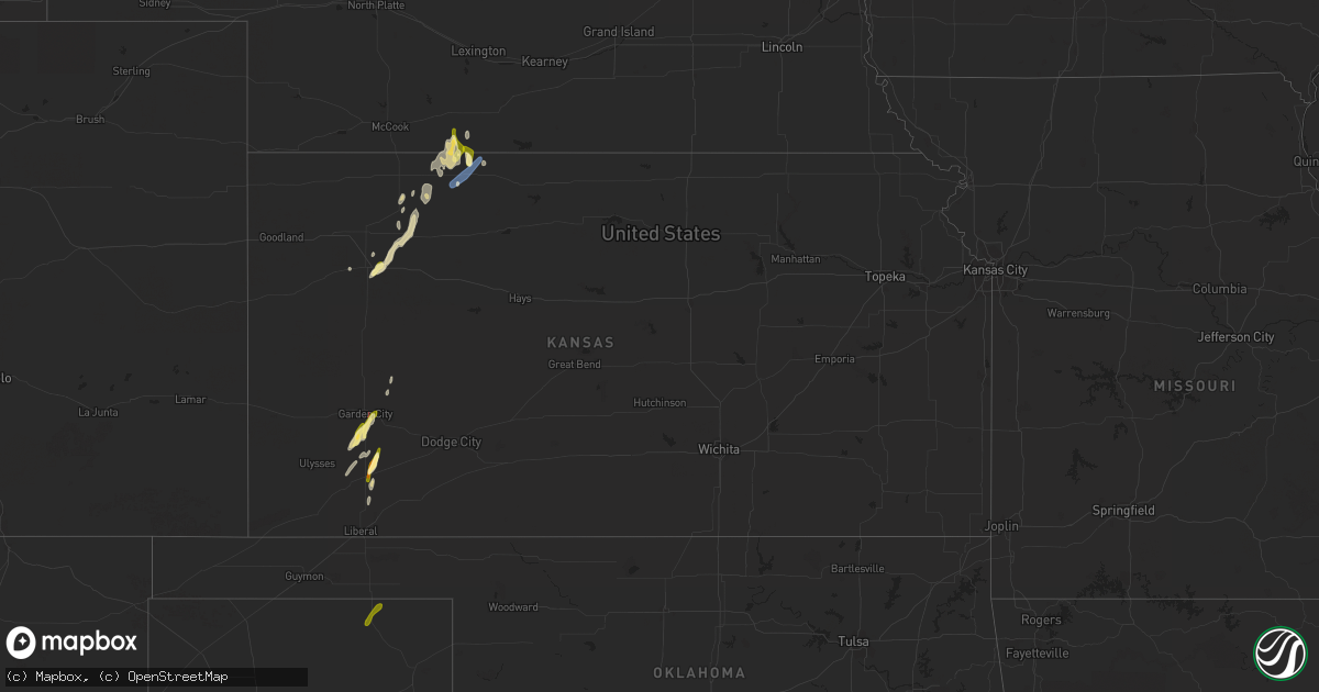
Hail Map in Kansas on March 24, 2024
Get this storm
March 24 map
$229
one time, instant access
Download today. No call, no setup
Keep the $229
Bought the map and want the full workflow? Apply the entire $229 to a subscription within 7 days. None of it is wasted.
Every map, not just this one
This buys you this map. Subscription and you get every map we run, in the markets you choose from a few cities to whole states to nationwide. Plus real-time alerts the moment a storm fires.
Contact data
Name, contact info, occupancy, even credit band for addresses in the footprint. You go from where it hit to who to call.
Become the source they trust
Unlimited branding weather history reports on demand. You already have the documented answer ready for the property owner, and you are the one who showed up with it.
Property data and RoofTrace estimates
Pull up any address you have got, its value and the exact code rules for that jurisdiction, straight from One Click Code. Then RoofTrace estimates the squares, pitch, and roof value, priced the way you price.
Storm reports in Kansas
Kansas
| Date | Description |
|---|---|
| 03/24/20245:55 PM CDT | Awos station knrn norton. |
| 03/24/20245:27 PM CDT | Based on webcams the hail is starting to accumulate on i-70. |
| 03/24/20245:20 PM CDT | The hail was a inch deep. Average size was dime with largest being quarter size. |
| 03/24/20245:15 PM CDT | Public report via social media with photo of estimated ping pong ball size hail. Time estimated from radar. |
| 03/24/20245:12 PM CDT | Saw second tornado develop to west of first one... Possibly near county road bb east of oakley. |
| 03/24/20245:05 PM CDT | Reported about a mile south of mp 77 on i-70. |
| 03/24/20243:57 PM CDT | A local report indicates 1.00 inch wind near 6 SW Plymell |
| 03/24/20243:50 PM CDT | Damage to roofs... Powerlines. And fences. Possibly tornado damage... In the wilson addition area. Time estimated. |
| 03/24/20243:48 PM CDT | [landspout] |
| 03/24/20243:30 PM CDT | Damage survey revealed a tornado occurred on the east side of garden city... Causing low-end ef-1 damage to homes and businesses. |
| 03/24/20243:20 PM CDT | A local report indicates 1.00 inch wind near 7 NNW Tice |
| 03/24/20243:08 PM CDT | A local report indicates 1.50 inch wind near Sublette |
| 03/24/20243:00 PM CDT | A local report indicates 1.50 inch wind near Sublette |
| 03/23/20247:18 PM CDT | Kansas highway patrol shared a picture of accumulating nickel to quarter size hail. |
Cities Impacted by Hail Map on March 24, 2024
- Shamrock, TX
- Sublette, KS
- Perryton, TX
- Garden City, KS
- Ulysses, KS
- Paducah, TX
- Seymour, TX
- Crowell, TX
- Vernon, TX
- Electra, TX
- Satanta, KS
- Selden, KS
- Norcatur, KS
- Kismet, KS
- Grinnell, KS
- Iowa Park, TX
- Norton, KS
- Hendley, NE
- Beaver City, NE
- Wilsonville, NE
- Almena, KS
- Wichita Falls, TX
- Sheppard Afb, TX
- Petrolia, TX
- Henrietta, TX
- Byers, TX
- Ryan, OK
- Holliday, TX
- Archer City, TX
- Windthorst, TX
- Scotland, TX
- Ringling, OK
- Healdton, OK
- Wilson, OK
- Hoxie, KS
- Oakley, KS
- Jennings, KS
- Oberlin, KS
- Dresden, KS
- Christoval, TX
- Monument, KS
- Madill, OK
- Ozona, TX
- Ranger, TX
- Tishomingo, OK
- Coleman, OK
- Milburn, OK
- Flower Mound, TX
- Lewisville, TX
- Lone Grove, OK
- Ardmore, OK
- Santo, TX
- Palo Pinto, TX
- Southlake, TX
- The Colony, TX
- Grapevine, TX
- Coppell, TX
- Carrollton, TX
- Gordon, TX
- Millsap, TX
- Mineral Wells, TX
- Lake Dallas, TX
- Argyle, TX
- Strawn, TX
- Kenefic, OK
- Wills Point, TX
- Kemp, TX
- Scurry, TX


