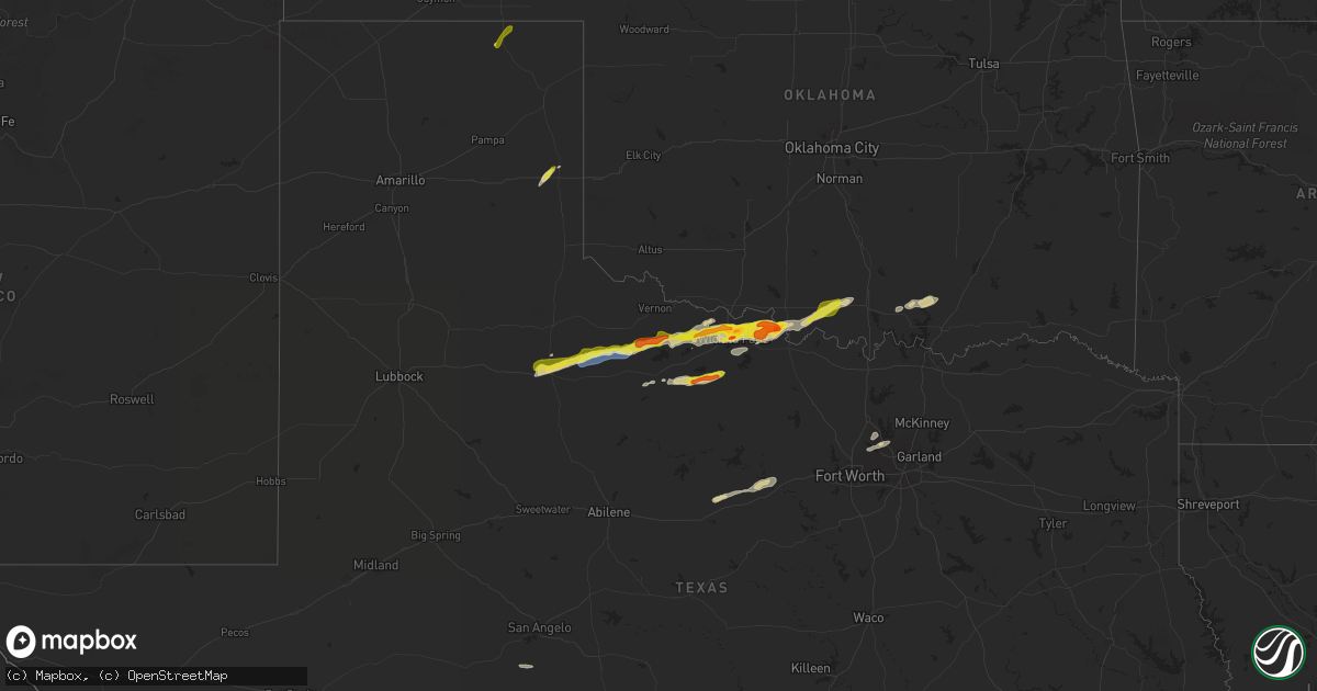
Hail Map on March 24, 2024
Get this storm
March 24 map
$229
one time, instant access
Download today. No call, no setup
Keep the $229
Bought the map and want the full workflow? Apply the entire $229 to a subscription within 7 days. None of it is wasted.
Every map, not just this one
This buys you this map. Subscription and you get every map we run, in the markets you choose from a few cities to whole states to nationwide. Plus real-time alerts the moment a storm fires.
Contact data
Name, contact info, occupancy, even credit band for addresses in the footprint. You go from where it hit to who to call.
Become the source they trust
Unlimited branding weather history reports on demand. You already have the documented answer ready for the property owner, and you are the one who showed up with it.
Property data and RoofTrace estimates
Pull up any address you have got, its value and the exact code rules for that jurisdiction, straight from One Click Code. Then RoofTrace estimates the squares, pitch, and roof value, priced the way you price.
Storm reports
Oklahoma
| Date | Description |
|---|---|
| 03/23/20248:40 PM CDT | A local report indicates 1.00 inch wind near 3 W Cornish |
| 03/23/20248:23 PM CDT | (o |
| 03/23/20248:23 PM CDT | A local report indicates 1.00 inch wind near 5 NNW Grady |
Texas
| Date | Description |
|---|---|
| 03/24/20246:57 PM CDT | A local report indicates 1.00 inch wind near Dean |
| 03/24/20246:43 PM CDT | A local report indicates 1.75 inch wind near Wichita Falls |
| 03/24/20246:33 PM CDT | A local report indicates 1.00 inch wind near 3 W Sheppard Afb |
| 03/24/20245:27 PM CDT | Trained spotters reported a confirmed tornado located to the ssw of grayback... Tx. Additional reports were also received from social media. |
| 03/24/20243:47 PM CDT | Reported came from over the phone. |
| 03/24/20243:41 PM CDT | A local report indicates 61 MPH wind near 1 E Mclean |
| 03/24/20243:17 PM CDT | This quick... Brief tornado touched down to the north of i-40. Spotters had reported a funnel cloud had crossed i-40... But no damage was noted. The tornado caused dama |
| 03/24/20243:05 PM CDT | Report of quarter size hail near the southwest loop road and spur 192. |
| 03/24/20243:05 PM CDT | This brief tornado touched down shortly after the first tornado as the mesocyclone occluded. Damage to a barn included loss of a door and some lifted roof panels near c |
| 03/24/20243:04 PM CDT | Corrects previous hail report from 1 s perryton. Reported came from over the phone. |
| 03/24/20243:03 PM CDT | Videos/pictures confirm a tornado touched down south of perryton. There is damage to a barn... A center pivot was knocked over... And the roof on the hospital on the so |
| 03/24/20242:58 PM CDT | The tornado developed in a field to the south of county road m. It then crossed county road m... Where it snapped three power poles and overturned a portion of an irrig |
| 03/24/20242:43 PM CDT | This tornado was photographed and filmed by multiple sources. It remained in a field and resulted in no known damage. |
| 03/24/20242:40 PM CDT | Mesonet station 121 lake mcclellan 2nw. |
| 03/24/20242:32 PM CDT | Mesonet station 35 clarendon 2w. |
| 03/23/20249:34 PM CDT | Estimated 50-60mph winds. |
| 03/23/20248:21 PM CDT | A local report indicates 1.00 inch wind near Archer City |
| 03/23/20247:36 PM CDT | A local report indicates 1.75 inch wind near 11 SE Byers |
Nebraska
| Date | Description |
|---|---|
| 03/24/20245:47 PM CDT | 3 miles n of state line on highway 283. Accompanied by 50 mph wind gusts. |
Kansas
| Date | Description |
|---|---|
| 03/24/20245:55 PM CDT | Awos station knrn norton. |
| 03/24/20245:27 PM CDT | Based on webcams the hail is starting to accumulate on i-70. |
| 03/24/20245:20 PM CDT | The hail was a inch deep. Average size was dime with largest being quarter size. |
| 03/24/20245:15 PM CDT | Public report via social media with photo of estimated ping pong ball size hail. Time estimated from radar. |
| 03/24/20245:12 PM CDT | Saw second tornado develop to west of first one... Possibly near county road bb east of oakley. |
| 03/24/20245:05 PM CDT | Reported about a mile south of mp 77 on i-70. |
| 03/24/20243:57 PM CDT | A local report indicates 1.00 inch wind near 6 SW Plymell |
| 03/24/20243:50 PM CDT | Damage to roofs... Powerlines. And fences. Possibly tornado damage... In the wilson addition area. Time estimated. |
| 03/24/20243:48 PM CDT | [landspout] |
| 03/24/20243:30 PM CDT | Damage survey revealed a tornado occurred on the east side of garden city... Causing low-end ef-1 damage to homes and businesses. |
| 03/24/20243:20 PM CDT | A local report indicates 1.00 inch wind near 7 NNW Tice |
| 03/24/20243:08 PM CDT | A local report indicates 1.50 inch wind near Sublette |
| 03/24/20243:00 PM CDT | A local report indicates 1.50 inch wind near Sublette |
| 03/23/20247:18 PM CDT | Kansas highway patrol shared a picture of accumulating nickel to quarter size hail. |
California
| Date | Description |
|---|---|
| 03/24/20245:15 PM CDT | A local report indicates 1.00 inch wind near 0.5 SE Azusa |
Maine
| Date | Description |
|---|---|
| 03/24/20249:43 AM CDT | Report from mping: 1-inch tree limbs broken; shingles blown off. |
Cities Impacted by Hail Map on March 24, 2024
- Shamrock, TX
- Sublette, KS
- Perryton, TX
- Garden City, KS
- Ulysses, KS
- Paducah, TX
- Seymour, TX
- Crowell, TX
- Vernon, TX
- Electra, TX
- Satanta, KS
- Selden, KS
- Norcatur, KS
- Kismet, KS
- Grinnell, KS
- Iowa Park, TX
- Norton, KS
- Hendley, NE
- Beaver City, NE
- Wilsonville, NE
- Almena, KS
- Wichita Falls, TX
- Sheppard Afb, TX
- Petrolia, TX
- Henrietta, TX
- Byers, TX
- Ryan, OK
- Holliday, TX
- Archer City, TX
- Windthorst, TX
- Scotland, TX
- Ringling, OK
- Healdton, OK
- Wilson, OK
- Hoxie, KS
- Oakley, KS
- Jennings, KS
- Oberlin, KS
- Dresden, KS
- Christoval, TX
- Monument, KS
- Madill, OK
- Ozona, TX
- Ranger, TX
- Tishomingo, OK
- Coleman, OK
- Milburn, OK
- Flower Mound, TX
- Lewisville, TX
- Lone Grove, OK
- Ardmore, OK
- Santo, TX
- Palo Pinto, TX
- Southlake, TX
- The Colony, TX
- Grapevine, TX
- Coppell, TX
- Carrollton, TX
- Gordon, TX
- Millsap, TX
- Mineral Wells, TX
- Lake Dallas, TX
- Argyle, TX
- Strawn, TX
- Kenefic, OK
- Wills Point, TX
- Kemp, TX
- Scurry, TX