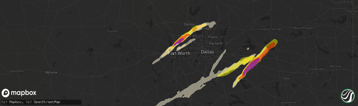
Hail Map in Fort Worth, TX on March 24, 2021
The weather event in Fort Worth, TX on March 24, 2021 includes Hail, Wind, and Tornado maps. 7 states and 273 cities were impacted and suffered possible damage. The total estimated number of properties impacted is 5,300.
Hail
Wind
Tornado
5,300
Estimated number of impacted properties by a 1.00" hail or larger4,796
Estimated number of impacted properties by a 1.75" hail or larger4,557
Estimated number of impacted properties by a 2.50" hail or largerStorm reports in Fort Worth, TX
Fort Worth, TX
| Date | Description |
|---|---|
| 03/23/20219:02 PM CDT | A local report indicates 1.75 inch wind near 2 E HASLET |
| 03/23/20219:02 PM CDT | Social media image of 2 inch hail. Time estimated via radar. |
| 03/23/20218:57 PM CDT | Report from mping: half dollar |
| 03/23/20218:55 PM CDT | Picture sent from near wagley robertson rd and w bonds ranch road. |
| 03/23/20218:52 PM CDT | Delayed report...2 inch hail stones measured a few miles north of saginaw. |
All States Impacted by Hail Map on March 24, 2021
All Cities Impacted by Hail Map on March 24, 2021
- Bonnerdale, AR
- Royal, AR
- Zephyr, TX
- Brownwood, TX
- Comanche, TX
- Early, TX
- Blanket, TX
- Mason, TX
- Barksdale, TX
- Graham, TX
- Jacksboro, TX
- Bryson, TX
- Rocksprings, TX
- Richland Springs, TX
- Rochelle, TX
- Austin, TX
- Fort Worth, TX
- Driftwood, TX
- Dripping Springs, TX
- Manor, TX
- Pflugerville, TX
- Coupland, TX
- Taylor, TX
- Elgin, TX
- Mount Vernon, TX
- Del Rio, TX
- Jefferson, AR
- Pine Bluff, AR
- White Hall, AR
- Sherrill, AR
- Tucker, AR
- England, AR
- Weatherford, TX
- Cisco, TX
- Sonora, TX
- Junction, TX
- London, TX
- Menard, TX
- Roosevelt, TX
- Edgewood, TX
- Wills Point, TX
- Canton, TX
- Mount Ida, AR
- Jessieville, AR
- Norman, AR
- Caddo Gap, AR
- Leakey, TX
- Camp Wood, TX
- Rio Frio, TX
- Lockesburg, AR
- Dierks, AR
- Waxahachie, TX
- Citronelle, AL
- Mabank, TX
- Fruitvale, TX
- Dublin, TX
- Talco, TX
- Mount Pleasant, TX
- Utopia, TX
- Uvalde, TX
- Itasca, TX
- Covington, TX
- Italy, TX
- Forreston, TX
- Milford, TX
- Blum, TX
- Maypearl, TX
- Grandview, TX
- Hillsboro, TX
- Frisco City, AL
- Alba, TX
- Emory, TX
- Brackettville, TX
- Hamilton, TX
- Hico, TX
- Brady, TX
- Bowie, TX
- Alvord, TX
- Saint Jo, TX
- Sunset, TX
- Chico, TX
- Forestburg, TX
- Iredell, TX
- Centreville, MS
- Norwood, LA
- Jackson, LA
- Wilson, LA
- Ethel, LA
- Saint Francisville, LA
- Kaufman, TX
- Llano, TX
- Castell, TX
- Fredericksburg, TX
- Roanoke, TX
- Flower Mound, TX
- Argyle, TX
- Keller, TX
- Haslet, TX
- Aubrey, TX
- Hext, TX
- Pontotoc, TX
- Mountain Home, TX
- Valley Spring, TX
- Art, TX
- Foreman, AR
- Winthrop, AR
- Cherokee, TX
- San Saba, TX
- Terrell, TX
- Evant, TX
- Goldthwaite, TX
- Baird, TX
- Kemp, TX
- Vanderpool, TX
- Medina, TX
- Palmer, TX
- Monroeville, AL
- Doole, TX
- Melvin, TX
- Eden, TX
- Lohn, TX
- Meridian, TX
- Morgan, TX
- Clifton, TX
- Cranfills Gap, TX
- Little River, AL
- Uriah, AL
- McIntosh, AL
- Jackson, AL
- Aledo, TX
- Little Elm, TX
- Lewisville, TX
- Southlake, TX
- Frisco, TX
- Mckinney, TX
- Denton, TX
- Lake Dallas, TX
- Prosper, TX
- Concan, TX
- Carlisle, AR
- Scurry, TX
- Seagoville, TX
- Glenwood, AR
- Mountain Pine, AR
- Winnsboro, TX
- Arkadelphia, AR
- Yantis, TX
- Whatley, AL
- Vredenburgh, AL
- Franklin, AL
- Eldorado, TX
- Christoval, TX
- De Queen, AR
- Newhope, AR
- Sparkman, AR
- Malvern, AR
- Rhome, TX
- Sherman, TX
- Pottsboro, TX
- De Kalb, TX
- Haworth, OK
- Hazen, AR
- Stuttgart, AR
- Eustace, TX
- Forney, TX
- Crandall, TX
- Scroggins, TX
- Dike, TX
- Sulphur Springs, TX
- Leola, AR
- Donaldson, AR
- Brookesmith, TX
- Horatio, AR
- Mesquite, TX
- Balch Springs, TX
- Ennis, TX
- Rosser, TX
- Wilmer, TX
- Ferris, TX
- Lancaster, TX
- Powell, TX
- Comfort, TX
- Laughlin Afb, TX
- Bismarck, AR
- Chatfield, TX
- Rice, TX
- Traskwood, AR
- Avery, TX
- Annona, TX
- Colleyville, TX
- Grapevine, TX
- Mena, AR
- Boles, AR
- Parks, AR
- Whitney, TX
- Red Oak, TX
- Dallas, TX
- Grand Saline, TX
- Kopperl, TX
- Kerens, TX
- North Richland Hills, TX
- Humnoke, AR
- Justin, TX
- Decatur, TX
- Azle, TX
- Princeton, TX
- Nashville, AR
- Bandera, TX
- Como, TX
- Rockdale, TX
- Rogers City, MI
- Walnut Springs, TX
- Comstock, TX
- Lometa, TX
- Umpire, AR
- Van, TX
- Langley, AR
- Kirby, AR
- Ben Wheeler, TX
- De Valls Bluff, AR
- Quitman, TX
- D Hanis, TX
- Voca, TX
- Fredonia, TX
- Mullin, TX
- Tishomingo, OK
- Centrahoma, OK
- Tupelo, OK
- Milburn, OK
- Coalgate, OK
- Bogata, TX
- Thorndale, TX
- Atmore, AL
- New Roads, LA
- Ventress, LA
- Jarreau, LA
- Mineola, TX
- Copperas Cove, TX
- Hurst, TX
- Coppell, TX
- Haltom City, TX
- Liberty, MS
- Farmersville, TX
- Blue Ridge, TX
- Cove, AR
- Vandervoort, AR
- Wickes, AR
- The Colony, TX
- Lillie, LA
- Gatesville, TX
- Deport, TX
- Spearsville, LA
- Bernice, LA
- Pickton, TX
- Melissa, TX
- Ashdown, AR
- Plano, TX
- Muenster, TX
- Breckenridge, TX
- Wapanucka, OK
- Stonewall, OK
- Erwinville, LA
- Zachary, LA
- Amity, AR
- Point, TX
- Lake Creek, TX
- Sulphur Bluff, TX
- Cooper, TX
- Okolona, AR
- Tarpley, TX
- South Bend, TX
- Cross Plains, TX
- Jonesboro, TX


