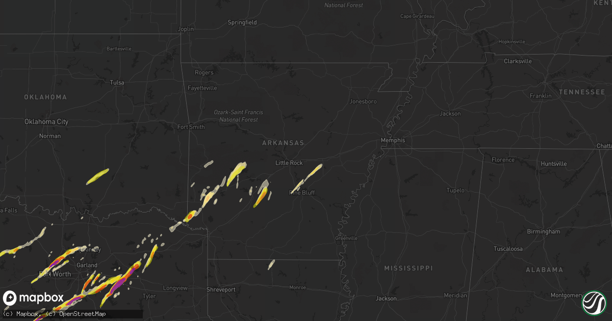
Hail Map in Arkansas on March 24, 2021
Get this storm
March 24 map
$229
one time, instant access
Download today. No call, no setup
Keep the $229
Bought the map and want the full workflow? Apply the entire $229 to a subscription within 7 days. None of it is wasted.
Every map, not just this one
This buys you this map. Subscription and you get every map we run, in the markets you choose from a few cities to whole states to nationwide. Plus real-time alerts the moment a storm fires.
Contact data
Name, contact info, occupancy, even credit band for addresses in the footprint. You go from where it hit to who to call.
Become the source they trust
Unlimited branding weather history reports on demand. You already have the documented answer ready for the property owner, and you are the one who showed up with it.
Property data and RoofTrace estimates
Pull up any address you have got, its value and the exact code rules for that jurisdiction, straight from One Click Code. Then RoofTrace estimates the squares, pitch, and roof value, priced the way you price.
Storm reports in Arkansas
Arkansas
| Date | Description |
|---|---|
| 03/24/20216:26 AM CDT | At 1126 PM CDT, a severe thunderstorm was located near Norman, or 7 miles southeast of Mount Ida, moving northeast at 35 mph. HAZARD...Half dollar size hail. SOURCE...Radar indicated. IMPACT...Damage to vehicles is expected. Locations impacted include... Mount Ida... Glenwood... Norman... Avant... Crystal Springs Landing... Mt Tabor... Fannie... Lena Landing Rec Area... Silver... Hurricane Grove... Story... Caddo Gap... Washita... |
| 03/24/20215:52 AM CDT | At 1051 PM CDT, a severe thunderstorm was located near Daisy, or 11 miles east of Umpire, moving northeast at 35 mph. HAZARD...60 mph wind gusts and half dollar size hail. SOURCE...Radar indicated. IMPACT...Hail damage to vehicles is expected. Expect wind damage to roofs, siding, and trees. Locations impacted include... Glenwood... Norman... Albert Pike Recreation Area... Black Springs... Fancyhill... Salem in Pike County... Hopper... Lodi... Caddo Gap... |
| 03/24/20215:31 AM CDT | At 1030 PM CDT, a severe thunderstorm was located over Dierks, moving northeast at 35 mph. HAZARD...Ping pong ball size hail and 60 mph wind gusts. SOURCE...Radar indicated. IMPACT...People and animals outdoors will be injured. Expect hail damage to roofs, siding, windows, and vehicles. Expect wind damage to roofs, siding, and trees. Locations impacted include... Daisy... New Hope in Pike County... Langley... |
| 03/24/20215:26 AM CDT | At 1026 PM CDT, a severe thunderstorm was located just southwest of Dierks, moving northeast at 40 mph. HAZARD...Ping pong ball size hail. SOURCE...Radar indicated. IMPACT...People and animals outdoors will be injured. Expect damage to roofs, siding, windows, and vehicles. Locations impacted include... Dierks, Muddy Fork, Lebanon and Provo. |
| 03/24/202112:20 AM CDT | Half dollar size hail was noted between donaldson and lono. |
| 03/24/202112:20 AM CDT | Half dollar size hail was noted between donaldson and lono. |
| 03/23/202110:30 PM CDT | Golfball size hail fell in dierks. Report relayed by wfo little rock. |
| 03/23/202110:00 PM CDT | A local report indicates 1.75 inch wind near 1 ENE WINTHROP |
| 03/23/20219:59 PM CDT | A local report indicates 1.75 inch wind near 3 SW WINTHROP |
| 03/23/20219:42 PM CDT | A picture was posted to social media of quarter of half dollar size hail that fell in foreman. |
All States Impacted by Hail Map on March 24, 2021
Cities Impacted by Hail Map on March 24, 2021
- Bonnerdale, AR
- Royal, AR
- Zephyr, TX
- Brownwood, TX
- Comanche, TX
- Early, TX
- Blanket, TX
- Mason, TX
- Barksdale, TX
- Graham, TX
- Jacksboro, TX
- Bryson, TX
- Rocksprings, TX
- Richland Springs, TX
- Rochelle, TX
- Austin, TX
- Fort Worth, TX
- Driftwood, TX
- Dripping Springs, TX
- Manor, TX
- Pflugerville, TX
- Coupland, TX
- Taylor, TX
- Elgin, TX
- Mount Vernon, TX
- Del Rio, TX
- Jefferson, AR
- Pine Bluff, AR
- White Hall, AR
- Sherrill, AR
- Tucker, AR
- England, AR
- Weatherford, TX
- Cisco, TX
- Sonora, TX
- Junction, TX
- London, TX
- Menard, TX
- Roosevelt, TX
- Edgewood, TX
- Wills Point, TX
- Canton, TX
- Mount Ida, AR
- Jessieville, AR
- Norman, AR
- Caddo Gap, AR
- Leakey, TX
- Camp Wood, TX
- Rio Frio, TX
- Lockesburg, AR
- Dierks, AR
- Waxahachie, TX
- Citronelle, AL
- Mabank, TX
- Fruitvale, TX
- Dublin, TX
- Talco, TX
- Mount Pleasant, TX
- Utopia, TX
- Uvalde, TX
- Itasca, TX
- Covington, TX
- Italy, TX
- Forreston, TX
- Milford, TX
- Blum, TX
- Maypearl, TX
- Grandview, TX
- Hillsboro, TX
- Frisco City, AL
- Alba, TX
- Emory, TX
- Brackettville, TX
- Hamilton, TX
- Hico, TX
- Brady, TX
- Bowie, TX
- Alvord, TX
- Saint Jo, TX
- Sunset, TX
- Chico, TX
- Forestburg, TX
- Iredell, TX
- Centreville, MS
- Norwood, LA
- Jackson, LA
- Wilson, LA
- Ethel, LA
- Saint Francisville, LA
- Kaufman, TX
- Llano, TX
- Castell, TX
- Fredericksburg, TX
- Roanoke, TX
- Flower Mound, TX
- Argyle, TX
- Keller, TX
- Haslet, TX
- Aubrey, TX
- Hext, TX
- Pontotoc, TX
- Mountain Home, TX
- Valley Spring, TX
- Art, TX
- Foreman, AR
- Winthrop, AR
- Cherokee, TX
- San Saba, TX
- Terrell, TX
- Evant, TX
- Goldthwaite, TX
- Baird, TX
- Kemp, TX
- Vanderpool, TX
- Medina, TX
- Palmer, TX
- Monroeville, AL
- Doole, TX
- Melvin, TX
- Eden, TX
- Lohn, TX
- Meridian, TX
- Morgan, TX
- Clifton, TX
- Cranfills Gap, TX
- Little River, AL
- Uriah, AL
- McIntosh, AL
- Jackson, AL
- Aledo, TX
- Little Elm, TX
- Lewisville, TX
- Southlake, TX
- Frisco, TX
- Mckinney, TX
- Denton, TX
- Lake Dallas, TX
- Prosper, TX
- Concan, TX
- Carlisle, AR
- Scurry, TX
- Seagoville, TX
- Glenwood, AR
- Mountain Pine, AR
- Winnsboro, TX
- Arkadelphia, AR
- Yantis, TX
- Whatley, AL
- Vredenburgh, AL
- Franklin, AL
- Eldorado, TX
- Christoval, TX
- De Queen, AR
- Newhope, AR
- Sparkman, AR
- Malvern, AR
- Rhome, TX
- Sherman, TX
- Pottsboro, TX
- De Kalb, TX
- Haworth, OK
- Hazen, AR
- Stuttgart, AR
- Eustace, TX
- Forney, TX
- Crandall, TX
- Scroggins, TX
- Dike, TX
- Sulphur Springs, TX
- Leola, AR
- Donaldson, AR
- Brookesmith, TX
- Horatio, AR
- Mesquite, TX
- Balch Springs, TX
- Ennis, TX
- Rosser, TX
- Wilmer, TX
- Ferris, TX
- Lancaster, TX
- Powell, TX
- Comfort, TX
- Laughlin Afb, TX
- Bismarck, AR
- Chatfield, TX
- Rice, TX
- Traskwood, AR
- Avery, TX
- Annona, TX
- Colleyville, TX
- Grapevine, TX
- Mena, AR
- Boles, AR
- Parks, AR
- Whitney, TX
- Red Oak, TX
- Dallas, TX
- Grand Saline, TX
- Kopperl, TX
- Kerens, TX
- North Richland Hills, TX
- Humnoke, AR
- Justin, TX
- Decatur, TX
- Azle, TX
- Princeton, TX
- Nashville, AR
- Bandera, TX
- Como, TX
- Rockdale, TX
- Rogers City, MI
- Walnut Springs, TX
- Comstock, TX
- Lometa, TX
- Umpire, AR
- Van, TX
- Langley, AR
- Kirby, AR
- Ben Wheeler, TX
- De Valls Bluff, AR
- Quitman, TX
- D Hanis, TX
- Voca, TX
- Fredonia, TX
- Mullin, TX
- Tishomingo, OK
- Centrahoma, OK
- Tupelo, OK
- Milburn, OK
- Coalgate, OK
- Bogata, TX
- Thorndale, TX
- Atmore, AL
- New Roads, LA
- Ventress, LA
- Jarreau, LA
- Mineola, TX
- Copperas Cove, TX
- Hurst, TX
- Coppell, TX
- Haltom City, TX
- Liberty, MS
- Farmersville, TX
- Blue Ridge, TX
- Cove, AR
- Vandervoort, AR
- Wickes, AR
- The Colony, TX
- Lillie, LA
- Gatesville, TX
- Deport, TX
- Spearsville, LA
- Bernice, LA
- Pickton, TX
- Melissa, TX
- Ashdown, AR
- Plano, TX
- Muenster, TX
- Breckenridge, TX
- Wapanucka, OK
- Stonewall, OK
- Erwinville, LA
- Zachary, LA
- Amity, AR
- Point, TX
- Lake Creek, TX
- Sulphur Bluff, TX
- Cooper, TX
- Okolona, AR
- Tarpley, TX
- South Bend, TX
- Cross Plains, TX
- Jonesboro, TX


