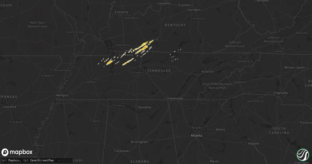
Hail Map in Tennessee on March 24, 2013
Get this storm
March 24 map
$229
one time, instant access
Download today. No call, no setup
Keep the $229
Bought the map and want the full workflow? Apply the entire $229 to a subscription within 7 days. None of it is wasted.
Every map, not just this one
This buys you this map. Subscription and you get every map we run, in the markets you choose from a few cities to whole states to nationwide. Plus real-time alerts the moment a storm fires.
Contact data
Name, contact info, occupancy, even credit band for addresses in the footprint. You go from where it hit to who to call.
Become the source they trust
Unlimited branding weather history reports on demand. You already have the documented answer ready for the property owner, and you are the one who showed up with it.
Property data and RoofTrace estimates
Pull up any address you have got, its value and the exact code rules for that jurisdiction, straight from One Click Code. Then RoofTrace estimates the squares, pitch, and roof value, priced the way you price.
Storm reports in Tennessee
Tennessee
| Date | Description |
|---|---|
| 03/24/20133:50 PM CDT | Trees and power lines down a few miles west of livingston. |
| 03/24/20131:26 PM CDT | Quarter sized hail was reported in northern parts of orlinda. |
| 03/24/20131:12 PM CDT | Reports of nickel to quarter sized hail fell in downtown springfield. |
| 03/24/201312:33 PM CDT | 1.25 inch hail reported 4 miles northwest of charlotte. |
| 03/24/201312:11 PM CDT | Quarter size hail reported near cheatham dam |
| 03/24/201311:48 AM CDT | Houston county emergency management reported quarter sized hail around the community of mckinnon and houston county airport. |
| 03/24/201311:45 AM CDT | 1.5 inch hail reported by cocorahs observer. |
Cities Impacted by Hail Map on March 24, 2013
- Livingston, TN
- Allensville, KY
- Clarksville, TN
- Guthrie, KY
- Adams, TN
- Trenton, KY
- Woodburn, KY
- Bowling Green, KY
- Franklin, KY
- Auburn, KY
- Russellville, KY
- Rockfield, KY
- Adairville, KY
- Olmstead, KY
- Springfield, TN
- Webster, FL
- Groveland, FL
- Mascotte, FL
- Center Hill, FL
- Big Sandy, TN
- Vanleer, TN
- Charlotte, TN
- Cumberland Furnace, TN
- Dickson, TN
- Portland, TN
- Orlinda, TN
- Orlando, FL
- Titusville, FL
- Christmas, FL
- Ashland City, TN
- Mims, FL
- Springville, TN
- Stewart, TN
- Cross Plains, TN
- Alvaton, KY
- Albany, KY
- Lyons, GA
- Land O'Lakes, FL
- Dade City, FL
- Spring Hill, FL
- Cedar Hill, TN
- Paris, TN
- Buchanan, TN
- Winter Garden, FL
- Gotha, FL
- Windermere, FL
- Ocoee, FL
- Chapmansboro, TN
- Pleasant View, TN
- Clermont, FL
- Oakland, FL
- Mansfield, TN
- Dover, TN
- Hudson, FL
- Scottsville, KY
- Hoboken, GA
- Waycross, GA
- Metter, GA
- Cobbtown, GA
- Gleason, TN
- McKenzie, TN
- Henry, TN
- Oakland, KY
- Smiths Grove, KY
- Cookeville, TN
- Brooksville, FL
- Boston, GA
- Joelton, TN
- Celina, TN
- Woodlawn, TN
- Indian Mound, TN
- Burkesville, KY
- Perry, FL
- Cumberland City, TN
- Thomasville, GA
- Polk City, FL
- Waverly, TN
- Claxton, GA
- Collins, GA
- Geneva, FL
- Oviedo, FL
- White House, TN
- Cottontown, TN
- Allons, TN
- Greenbrier, TN
- Hilham, TN
- Erin, TN
- Okahumpka, FL
- Leesburg, FL
- Okeechobee, FL
- Montverde, FL
- Winter Park, FL
- Nahunta, GA
- Puryear, TN
- Park City, KY
- Mayo, FL
- Waynesville, GA
- Bruceton, TN
- Hollow Rock, TN
- Vidalia, GA
- Alpine, TN


