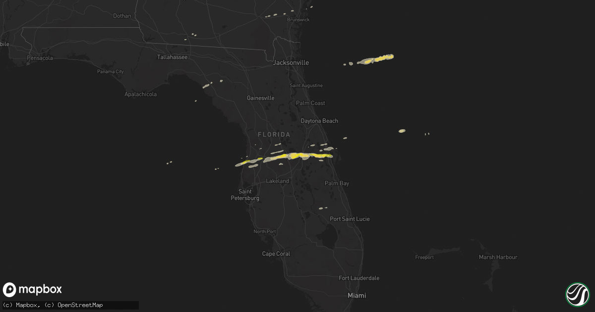
Hail Map on March 24, 2013
Get this storm
March 24 map
$229
one time, instant access
Download today. No call, no setup
Keep the $229
Bought the map and want the full workflow? Apply the entire $229 to a subscription within 7 days. None of it is wasted.
Every map, not just this one
This buys you this map. Subscription and you get every map we run, in the markets you choose from a few cities to whole states to nationwide. Plus real-time alerts the moment a storm fires.
Contact data
Name, contact info, occupancy, even credit band for addresses in the footprint. You go from where it hit to who to call.
Become the source they trust
Unlimited branding weather history reports on demand. You already have the documented answer ready for the property owner, and you are the one who showed up with it.
Property data and RoofTrace estimates
Pull up any address you have got, its value and the exact code rules for that jurisdiction, straight from One Click Code. Then RoofTrace estimates the squares, pitch, and roof value, priced the way you price.
Storm reports
Tennessee
| Date | Description |
|---|---|
| 03/24/20133:50 PM CDT | Trees and power lines down a few miles west of livingston. |
| 03/24/20131:26 PM CDT | Quarter sized hail was reported in northern parts of orlinda. |
| 03/24/20131:12 PM CDT | Reports of nickel to quarter sized hail fell in downtown springfield. |
| 03/24/201312:33 PM CDT | 1.25 inch hail reported 4 miles northwest of charlotte. |
| 03/24/201312:11 PM CDT | Quarter size hail reported near cheatham dam |
| 03/24/201311:48 AM CDT | Houston county emergency management reported quarter sized hail around the community of mckinnon and houston county airport. |
| 03/24/201311:45 AM CDT | 1.5 inch hail reported by cocorahs observer. |
Kentucky
| Date | Description |
|---|---|
| 03/24/20135:45 PM CDT | Damage occurred on fairfield avenue in corbin. The roof was torn from a doublewide trailer. Several trees were downed. An uprooted tree fell across a house and car. Sev |
| 03/24/20134:38 PM CDT | 60 foot by 100 foot metal building leveled and roof blown off under building. |
| 03/24/20134:16 PM CDT | Two roofs taken off storage buildings. Pulled post out of ground in cement. |
| 03/24/20131:25 PM CDT | Near highway 622 and the natcher parkway. |
| 03/24/20131:22 PM CDT | Up to quarter size hail at the state police post. |
| 03/24/20131:13 PM CDT | A local report indicates 1.75 inch wind near FRANKLIN |
| 03/24/20131:04 PM CDT | A local report indicates 1.00 inch wind near FRANKLIN |
| 03/24/201312:21 PM CDT | Quarter size hail reported by emergency management in clarksville near hwy 41a and 101st in the ringgold area. |
Florida
| Date | Description |
|---|---|
| 03/24/20135:30 PM CDT | Large tree limbs down. |
| 03/24/20135:25 PM CDT | Large tree limbs down. |
| 03/24/20133:00 PM CDT | Some asphalt roll roofing was blown off barn roof near intersection of aurora and wickham roads. |
| 03/24/20132:24 PM CDT | Trident pier trdf1 measured a wind gust of 58 kt/67 mph from the nw. |
| 03/24/20132:24 PM CDT | Cape canaveral air force station skid strip measured wind gust of 50 kt/58 mph from 290 degrees. |
| 03/24/20132:22 PM CDT | Strong straight line wind gust estimated to 63 mph. |
| 03/24/20132:21 PM CDT | Mesonet site ar909 measured wind gust of 50 kt/ 58 mph. |
| 03/24/20132:20 PM CDT | Roof damage to apartment building on adams ave. |
| 03/24/20132:15 PM CDT | Florida today and nws storm survey crew reported roof damage at wmel radio station on pluckelbaum rd. Large tree limbs down. |
| 03/24/20132:12 PM CDT | Roof damage to mobile home on poplar place. |
| 03/24/20132:07 PM CDT | Brevard emergency manager reported one plane flipped over at ktix - titusville airport. |
| 03/24/20132:05 PM CDT | Space coast regional airport ktix recorded a wind gust of 55 kt/63 mph |
| 03/24/20131:41 PM CDT | Korl asos measured a wind gust of 54kt/62 mph from 290 degrees. |
| 03/24/20131:40 PM CDT | Kmco asos measured a wind gust of 75 kt/86 mph from 300 drgrees. |
| 03/24/20131:39 PM CDT | Public reported quarter-sized hail south of county line road in pasco county. Time estimated based off radar. |
| 03/24/20131:32 PM CDT | Estimated wind gust 50 to 60 mph reported by skywarn spotter. |
| 03/24/20131:29 PM CDT | Measured wind gust of 86 mph from the west northwest in the doctor phillips area. |
| 03/24/20131:26 PM CDT | Quarter size hail. |
| 03/24/20131:25 PM CDT | Weatherflow site xrdy measured wind gust of 52kt/ 60 mph from 305 degrees. |
| 03/24/20131:15 PM CDT | Multiple broadcast media outlets are reporting wind damage in the dade city area including downed wires and transformer fires. |
| 03/24/20131:10 PM CDT | Quarter size hail fell for 10 minutes. Estimated sustained wind 45 mph. |
| 03/24/20131:05 PM CDT | Wtvt-tv relayed a viewer report of quarter-sized hail in fivay junction. |
| 03/24/201312:59 PM CDT | Hernando county sheriffs office has received numerous reports of trees down throughout hernando county. |
| 03/24/201312:52 PM CDT | Pasco county emergency management relayed reports of widespread wind damage in northeast pasco county. |
| 03/24/201312:17 PM CDT | Trained spotter reported quarter-sized hail in hudson. |
| 03/24/20139:40 AM CDT | *** 1 inj *** alachua county emergency management relayed a public report of a tree downed in gainesville by strong wind gusts. The tree damaged a house and resulted in |
| 03/24/20139:35 AM CDT | Alachua county emergency management relayed a public report of trees down on southeast county road 234. This road was closed due to downed trees blocking the road...but |
| 03/24/20139:15 AM CDT | Several trees were blown down aross driveways along ford road near u.s. Highway 301 near bryceville. The time of damage was based on radar imagery. |
| 03/24/20138:47 AM CDT | A spotter reported strcutral damage to his home due to thunderstorm winds. Trees and power lines were blown down. Wind gusts were estimated between 55 and 60 mph. |
| 03/24/20137:53 AM CDT | Winds downed a tree south of jennings along highway 41. |
Georgia
| Date | Description |
|---|---|
| 03/24/20138:33 AM CDT | A spotter reported trees and power lines were blown down in travisville...located between homerville and argyle. The time of damage was based on radar. |
| 03/24/20138:22 AM CDT | The public reported nickel to quarter sized hail. Time estimated based on radar. |
Cities Impacted by Hail Map on March 24, 2013
- Livingston, TN
- Allensville, KY
- Clarksville, TN
- Guthrie, KY
- Adams, TN
- Trenton, KY
- Woodburn, KY
- Bowling Green, KY
- Franklin, KY
- Auburn, KY
- Russellville, KY
- Rockfield, KY
- Adairville, KY
- Olmstead, KY
- Springfield, TN
- Webster, FL
- Groveland, FL
- Mascotte, FL
- Center Hill, FL
- Big Sandy, TN
- Vanleer, TN
- Charlotte, TN
- Cumberland Furnace, TN
- Dickson, TN
- Portland, TN
- Orlinda, TN
- Orlando, FL
- Titusville, FL
- Christmas, FL
- Ashland City, TN
- Mims, FL
- Springville, TN
- Stewart, TN
- Cross Plains, TN
- Alvaton, KY
- Albany, KY
- Lyons, GA
- Land O'Lakes, FL
- Dade City, FL
- Spring Hill, FL
- Cedar Hill, TN
- Paris, TN
- Buchanan, TN
- Winter Garden, FL
- Gotha, FL
- Windermere, FL
- Ocoee, FL
- Chapmansboro, TN
- Pleasant View, TN
- Clermont, FL
- Oakland, FL
- Mansfield, TN
- Dover, TN
- Hudson, FL
- Scottsville, KY
- Hoboken, GA
- Waycross, GA
- Metter, GA
- Cobbtown, GA
- Gleason, TN
- McKenzie, TN
- Henry, TN
- Oakland, KY
- Smiths Grove, KY
- Cookeville, TN
- Brooksville, FL
- Boston, GA
- Joelton, TN
- Celina, TN
- Woodlawn, TN
- Indian Mound, TN
- Burkesville, KY
- Perry, FL
- Cumberland City, TN
- Thomasville, GA
- Polk City, FL
- Waverly, TN
- Claxton, GA
- Collins, GA
- Geneva, FL
- Oviedo, FL
- White House, TN
- Cottontown, TN
- Allons, TN
- Greenbrier, TN
- Hilham, TN
- Erin, TN
- Okahumpka, FL
- Leesburg, FL
- Okeechobee, FL
- Montverde, FL
- Winter Park, FL
- Nahunta, GA
- Puryear, TN
- Park City, KY
- Mayo, FL
- Waynesville, GA
- Bruceton, TN
- Hollow Rock, TN
- Vidalia, GA
- Alpine, TN