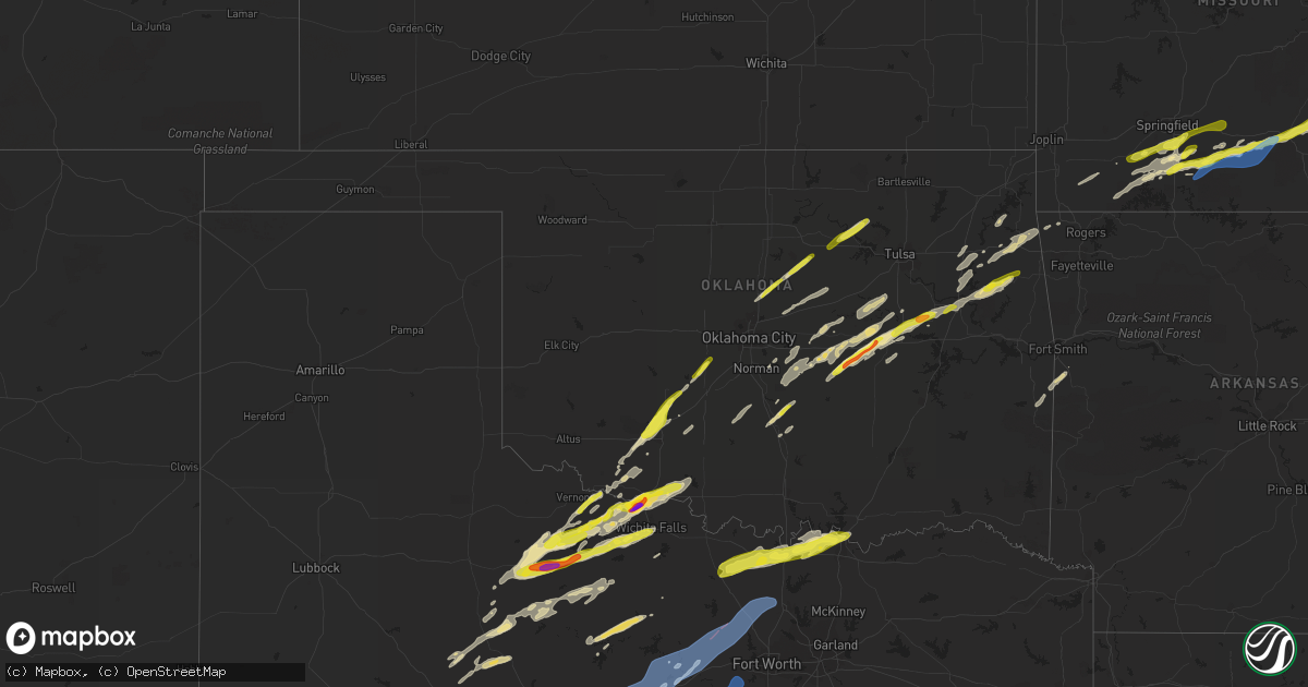
Hail Map in Oklahoma on March 23, 2023
Get this storm
March 23 map
$229
one time, instant access
Download today. No call, no setup
Keep the $229
Bought the map and want the full workflow? Apply the entire $229 to a subscription within 7 days. None of it is wasted.
Every map, not just this one
This buys you this map. Subscription and you get every map we run, in the markets you choose from a few cities to whole states to nationwide. Plus real-time alerts the moment a storm fires.
Contact data
Name, contact info, occupancy, even credit band for addresses in the footprint. You go from where it hit to who to call.
Become the source they trust
Unlimited branding weather history reports on demand. You already have the documented answer ready for the property owner, and you are the one who showed up with it.
Property data and RoofTrace estimates
Pull up any address you have got, its value and the exact code rules for that jurisdiction, straight from One Click Code. Then RoofTrace estimates the squares, pitch, and roof value, priced the way you price.
Storm reports in Oklahoma
Oklahoma
| Date | Description |
|---|---|
| 03/23/20236:00 PM CDT | A local report indicates 1.00 inch wind near ONETA |
| 03/23/20233:50 PM CDT | A local report indicates 1.50 inch wind near 3 NNW CLEARVIEW |
| 03/23/20233:45 PM CDT | Report from mping: ping pong ball |
| 03/23/20233:41 PM CDT | Report from mping: quarter |
| 03/23/20233:37 PM CDT | Dime to quarter size hail covering the ground. |
| 03/23/20233:37 PM CDT | Time and location estimated by radar. |
| 03/23/20233:30 PM CDT | A local report indicates 1.50 inch wind near 1 E BEARDEN |
| 03/23/20233:30 PM CDT | A local report indicates 1.00 inch wind near 5 S CROMWELL |
| 03/23/20233:25 PM CDT | A local report indicates 1.75 inch wind near 5 NNW WEWOKA |
| 03/22/20239:33 PM CDT | A local report indicates 1.00 inch wind near 3 N POCASSET |
| 03/22/20238:18 PM CDT | Reported at loves travel center. |
| 03/22/20238:08 PM CDT | A local report indicates 1.75 inch wind near 2 NNE BURKBURNETT |
All States Impacted by Hail Map on March 23, 2023
Cities Impacted by Hail Map on March 23, 2023
- Flora, IL
- Clay City, IL
- Xenia, IL
- Louisville, IL
- Iuka, IL
- Kinmundy, IL
- Cisne, IL
- Johnsonville, IL
- Olney, IL
- Noble, IL
- Rinard, IL
- Pauls Valley, OK
- Byars, OK
- Wewoka, OK
- Seminole, OK
- Wetumka, OK
- Okemah, OK
- Vernon, TX
- Harrold, TX
- Weleetka, OK
- Oklaunion, TX
- Perkins, OK
- Stillwater, OK
- Ripley, OK
- Henryetta, OK
- Okmulgee, OK
- Morris, OK
- Glencoe, OK
- Boynton, OK
- Maramec, OK
- Pawnee, OK
- Guthrie, OK
- Cleveland, OK
- Jennings, OK
- Coyle, OK
- Meridian, OK
- Oktaha, OK
- Hominy, OK
- Osage, OK
- Muskogee, OK
- Fort Gibson, OK
- Hulbert, OK
- Tahlequah, OK
- Proctor, OK
- Walnut Shade, MO
- Spokane, MO
- Reeds Spring, MO
- Chestnutridge, MO
- Forsyth, MO
- Ozark, MO
- Chadwick, MO
- Garrison, MO
- Ava, MO
- Oldfield, MO
- Cassville, MO
- Maysville, OK
- Lindsay, OK
- Bristow, OK
- Beggs, OK
- Castle, OK
- Prague, OK
- Sparks, OK
- Meeker, OK
- Welling, OK
- Chouteau, OK
- Wagoner, OK
- Locust Grove, OK
- Paden, OK
- Barnsdall, OK
- Colcord, OK
- Galena, MO
- Electra, TX
- Noble, OK
- Norman, OK
- Youngstown, OH
- Bradley, OK
- Jay, OK
- Peggs, OK
- Oaks, OK
- Kansas, OK
- Twin Oaks, OK
- Rose, OK
- Purcell, OK
- Lowellville, OH
- Paoli, OK
- Lexington, OK
- Wayne, OK
- Newalla, OK
- Boley, OK
- Porter, OK
- Salem, IL
- Cape Fair, MO
- Aurora, MO
- Washington, OK
- Blanchard, OK
- Yale, OK
- Bowlegs, OK
- Maud, OK
- Haskell, OK
- Edmond, OK
- Seymour, MO
- Coweta, OK
- Norwood, MO
- Drury, MO
- Sparta, MO
- Crowell, TX
- Seymour, TX
- Rogersville, MO
- Bruner, MO
- Mountain Grove, MO
- Vanzant, MO
- Cabool, MO
- Elk Creek, MO
- Willow Springs, MO
- Houston, MO
- Yukon, MO
- Eunice, MO
- Summersville, MO
- Hartshorn, MO
- Eminence, MO
- Salem, MO
- Iowa Park, TX
- Burkburnett, TX
- Devol, OK
- Munday, TX
- Knox City, TX
- Randlett, OK
- Temple, OK
- Goree, TX
- Ellington, MO
- Redford, MO
- Centerville, MO
- Lesterville, MO
- Bunker, MO
- Annapolis, MO
- Ironton, MO
- Arcadia, MO
- Fredericktown, MO
- Farmington, MO
- Lawton, OK
- Elgin, OK
- Medicine Park, OK
- Apache, OK
- Anadarko, OK
- Holliday, TX
- Pocasset, OK
- Chickasha, OK
- Minco, OK
- Tuttle, OK
- Wichita Falls, TX
- Crane, MO
- Marionville, MO
- Billings, MO
- Clever, MO
- Nixa, MO
- Fordland, MO
- Vulcan, MO
- Alex, OK
- Grandfield, OK
- Rotan, TX
- Gravette, AR
- Decatur, AR
- Hollister, OK
- Loveland, OK
- Aspermont, TX
- Corning, CA
- Sterling City, TX
- Chico, CA
- Roby, TX
- Sylvester, TX
- Sweetwater, TX
- Benjamin, TX
- Inola, OK
- Fletcher, OK
- Rush Springs, OK
- Marlow, OK
- Tryon, OK
- Stroud, OK
- Cushing, OK
- Carney, OK
- Agra, OK
- Wellston, OK
- Chandler, OK
- Earlsboro, OK
- Cache, OK
- Indiahoma, OK
- Chattanooga, OK
- Frederick, OK
- McCaulley, TX
- Hamlin, TX
- Anson, TX
- Shawnee, OK
- Rule, TX
- Mounds, OK
- Faxon, OK
- Tecumseh, OK
- Highlandville, MO
- Ponce De Leon, MO
- Old Glory, TX
- Eucha, OK
- Spavinaw, OK
- Luther, OK
- Wheaton, MO
- Purdy, MO
- Rocky Comfort, MO
- Fairview, MO
- Macomb, OK
- Wanette, OK
- Mcloud, OK
- Waurika, OK
- Paducah, TX
- Comanche, OK
- Park Hill, OK
- Shell Knob, MO
- Walters, OK
- Davidson, OK
- Taneyville, MO
- Bradleyville, MO
- Squires, MO
- Midkiff, TX
- Big Lake, TX
- Wynnewood, OK
- Council Hill, OK
- Ozona, TX
- Verden, OK
- Bronte, TX
- Carlsbad, TX
- Robert Lee, TX
- Ballinger, TX
- San Angelo, TX
- Norton, TX
- Miles, TX
- Graham, TX
- Woodson, TX
- Breckenridge, TX
- Newcastle, TX
- Mertzon, TX
- Forestburg, TX
- Muenster, TX
- Montague, TX
- Sunset, TX
- Bowie, TX
- Saint Jo, TX
- Verona, MO
- Eldorado, TX
- Stratford, OK
- Winters, TX
- Throckmorton, TX
- Dustin, OK
- Haskell, TX
- Weinert, TX
- Rankin, TX
- McCamey, TX
- Iraan, TX
- Olney, TX
- Hedgesville, WV
- Martinsburg, WV
- Jacksboro, TX
- Mansfield, MO
- Ranger, TX
- De Leon, TX
- Desdemona, TX
- Mingus, TX
- Strawn, TX
- Dublin, TX
- Stephenville, TX
- Gordon, TX
- Palo Pinto, TX
- Santo, TX
- Graford, TX
- Mineral Wells, TX
- Bluff Dale, TX
- Millsap, TX
- Perrin, TX
- Weatherford, TX
- Poolville, TX
- Tolar, TX
- Granbury, TX
- Lipan, TX
- Springtown, TX
- Paradise, TX
- Boyd, TX
- Azle, TX
- Eastland, TX
- Talpa, TX
- Cresson, TX
- Newark, TX
- Decatur, TX
- Rhome, TX
- Ponder, TX
- Godley, TX
- Fort Worth, TX
- Coleman, TX
- Novice, TX
- Krum, TX
- Aledo, TX
- Gainesville, TX
- Lindsay, TX
- Whitesboro, TX
- Sadler, TX
- Sherman, TX
- Pottsboro, TX
- Denison, TX
- Cartwright, OK
- Colbert, OK
- Sonora, TX
- Cross Plains, TX
- Burkett, TX
- Hackett, AR
- Comanche, TX
- Menard, TX
- May, TX
- Greenwood, AR
- Brownwood, TX
- Santa Anna, TX
- Gorman, TX
- Rising Star, TX
- Sidney, TX
- Early, TX
- Blanket, TX
- Bangs, TX
- Geff, IL
- Howe, OK
- Heavener, OK
- Poteau, OK
- Huntington, AR
- Cameron, OK
- Gordonville, TX
- Thackerville, OK
- Wingate, TX
- Henrietta, TX
- Windthorst, TX
- Scotland, TX
- Albany, TX
- Goldsboro, TX
- Tuscola, TX
- Cisco, TX
- Carbon, TX
- Belleview, MO
- Hastings, OK
- Goldthwaite, TX
- Mullin, TX


