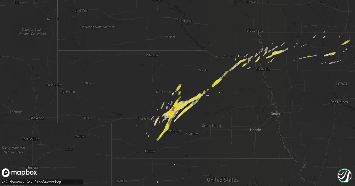
Hail Map in Nebraska on March 23, 2017
Get this storm
March 23 map
$229
one time, instant access
Download today. No call, no setup
Keep the $229
Bought the map and want the full workflow? Apply the entire $229 to a subscription within 7 days. None of it is wasted.
Every map, not just this one
This buys you this map. Subscription and you get every map we run, in the markets you choose from a few cities to whole states to nationwide. Plus real-time alerts the moment a storm fires.
Contact data
Name, contact info, occupancy, even credit band for addresses in the footprint. You go from where it hit to who to call.
Become the source they trust
Unlimited branding weather history reports on demand. You already have the documented answer ready for the property owner, and you are the one who showed up with it.
Property data and RoofTrace estimates
Pull up any address you have got, its value and the exact code rules for that jurisdiction, straight from One Click Code. Then RoofTrace estimates the squares, pitch, and roof value, priced the way you price.
Storm reports in Nebraska
Nebraska
| Date | Description |
|---|---|
| 03/23/20179:30 AM CDT | A local report indicates 1.25 inch wind near WYNOT |
| 03/22/201710:48 PM CDT | A local report indicates 60 MPH wind near GRAND ISLAND AIRPORT |
| 03/22/201710:42 PM CDT | A local report indicates 60 MPH wind near MARQUETTE |
| 03/22/201710:33 PM CDT | A local report indicates 70 MPH wind near GRAND ISLAND AIRPORT |
| 03/22/201710:31 PM CDT | A local report indicates 63 MPH wind near 4 SSE CHAPMAN |
| 03/22/201710:28 PM CDT | A local report indicates 67 MPH wind near 3 W PHILLIPS |
| 03/22/201710:16 PM CDT | A local report indicates 62 MPH wind near GRAND ISLAND AIRPORT |
| 03/22/201710:02 PM CDT | A local report indicates 74 MPH wind near 2 SE JOHNSON LAKE |
| 03/22/201710:00 PM CDT | A local report indicates 58 MPH wind near 3 ESE OVERTON |
| 03/22/20179:55 PM CDT | A local report indicates 67 MPH wind near KEARNEY AIRPORT |
| 03/22/20179:55 PM CDT | A pole barn was damaged along 115th road north of kearney. A portion of the road remains blocked. Used kearney awos peak gust time. |
| 03/22/20179:30 PM CDT | A local report indicates 60 MPH wind near 1 ENE ODESSA |
| 03/22/20179:30 PM CDT | A local report indicates 58 MPH wind near 6 W GIBBON |
| 03/22/20179:22 PM CDT | A local report indicates 64 MPH wind near 8 S ODESSA |
| 03/22/20179:21 PM CDT | A local report indicates 69 MPH wind near 6 NNE LOOMIS |
| 03/22/20179:20 PM CDT | Multiple power poles snapped as well as a hay barn receiving significant damage. . |
| 03/22/20179:15 PM CDT | A local report indicates 62 MPH wind near HOLDREGE |
| 03/22/20179:08 PM CDT | Wind gusts estimated to be near 60 mph. |
| 03/22/20179:04 PM CDT | A local report indicates 72 MPH wind near 6 ESE OXFORD |
| 03/22/20179:00 PM CDT | Some power outages and building damage in other areas of furnas county reported. . |
| 03/22/20178:52 PM CDT | A local report indicates 63 MPH wind near 4 SE OXFORD |
| 03/22/20178:52 PM CDT | A local report indicates 63 MPH wind near 4 SE OXFORD |
| 03/22/20178:34 PM CDT | Hail reported on callaway road. |
| 03/22/20178:05 PM CDT | A local report indicates 1.00 inch wind near 4 W ARCADIA |
| 03/22/20178:05 PM CDT | Quarter to half dollar sized hail |
| 03/22/20177:30 PM CDT | A local report indicates 1.00 inch wind near 4 W BROKEN BOW |
| 03/22/20177:25 PM CDT | Report via social media of tennis ball size hail. |
| 03/22/20177:20 PM CDT | A local report indicates 1.25 inch wind near 13 E CALLAWAY |
All States Impacted by Hail Map on March 23, 2017
Cities Impacted by Hail Map on March 23, 2017
- Grainfield, KS
- Spring Valley, MN
- Ostrander, MN
- Maxwell, NE
- Middleton, WI
- Verona, WI
- Madison, WI
- Black Earth, WI
- Cross Plains, WI
- Mount Horeb, WI
- Marco Island, FL
- Dumas, TX
- Merna, NE
- Arnold, NE
- Anselmo, NE
- Callaway, NE
- Edgerton, WI
- Readlyn, IA
- Fort Atkinson, WI
- Whitewater, WI
- Palmyra, WI
- Adrian, TX
- Vega, TX
- Ord, NE
- Merrill, IA
- Aurora, IA
- Janesville, IA
- Oelwein, IA
- Lamont, IA
- Stanley, IA
- Fairbank, IA
- Strawberry Point, IA
- Arlington, IA
- Waverly, IA
- Denver, IA
- Oran, IA
- Albert City, IA
- Hartington, NE
- Clewiston, FL
- Farnam, NE
- Cozad, NE
- Farmersburg, IA
- Fennimore, WI
- Garnavillo, IA
- Livingston, WI
- Bloomington, WI
- Saint Olaf, IA
- Prairie Du Chien, WI
- Bagley, WI
- Cobb, WI
- Lancaster, WI
- Montfort, WI
- Highland, WI
- Dodgeville, WI
- Stitzer, WI
- Elkader, IA
- Glen Haven, WI
- Saint Helena, NE
- Fordyce, NE
- Stanton, TX
- Midland, TX
- Wausa, NE
- Keyes, OK
- McGregor, IA
- Ochopee, FL
- Chokoloskee, FL
- Sherrill, IA
- Holy Cross, IA
- North Buena Vista, IA
- Brewster, NE
- De Soto, WI
- Lubbock, TX
- Vero Beach, FL
- Wynot, NE
- Hull, IA
- Boyden, IA
- Naples, FL
- Goodland, FL
- Blue Mounds, WI
- Barneveld, WI
- Murdock, MN
- Gruver, TX
- Mineral Point, WI
- Rewey, WI
- Platteville, WI
- Taylor, NE
- Swaledale, IA
- Clear Lake, IA
- Ansley, NE
- Arcadia, NE
- Oconto, NE
- Brady, NE
- Shell Rock, IA
- Vermillion, SD
- Burbank, SD
- Newcastle, NE
- Maskell, NE
- Broken Bow, NE
- Eustis, NE
- Eagle, WI
- Elyria, NE
- Comstock, NE
- Elkhart, KS
- Morse, TX
- Wildorado, TX
- Stinnett, TX
- Sunray, TX
- Amarillo, TX
- Hereford, TX
- Masterson, TX
- Blanchardville, WI
- Argyle, WI
- Darlington, WI
- Fort Pierce, FL
- Stoughton, WI
- Mukwonago, WI
- Bokeelia, FL
- Durand, IL
- Monticello, WI
- Belleville, WI
- New Glarus, WI
- Channing, TX
- Ericson, NE
- Westerville, NE
- Burwell, NE
- Corwith, IA
- Livermore, IA
- Renwick, IA
- Hardy, IA
- Kanawha, IA
- Rockford, IL
- Rockton, IL
- Caledonia, MN
- Edgewood, IA
- Maynard, IA
- Fayette, IA
- Brunsville, IA
- Le Mars, IA
- Clearwater, NE
- Neligh, NE
- Marienthal, KS
- Captiva, FL
- Woodman, WI
- Coleridge, NE
- Orange City, IA
- Alton, IA
- Hospers, IA
- Sheldon, IA
- Ruthven, IA
- Goodwell, OK
- Garner, IA
- Manly, IA
- Mason City, IA
- Ventura, IA
- Healy, KS
- Scott City, KS
- Brunswick, NE
- Plainview, NE
- Elgin, NE
- Ewing, NE
- Ulysses, KS
- Johnson, KS
- Franksville, WI
- Caledonia, WI
- Racine, WI
- Remsen, IA
- Granville, IA
- Paullina, IA
- Oregon, WI
- Jefferson, WI
- East Troy, WI
- Postville, IA
- Rowan, IA
- Stratford, TX
- Dalhart, TX
- Hartley, TX
- Mullen, NE
- Valentine, NE
- Benson, MN
- Curtis, NE
- Spring Grove, MN
- Eitzen, MN
- Archer, IA
- Sanborn, IA
- Elgin, IA
- Stewartville, MN
- Clarion, IA
- Eagle Grove, IA
- Muscoda, WI
- Lone Rock, WI
- Blue River, WI
- Patch Grove, WI
- Mount Hope, WI
- Texhoma, OK
- Fountain, MN
- Wykoff, MN
- Dorchester, IA
- Odessa, TX
- Wallace, NE
- Hugoton, KS
- Hooker, OK
- Muskego, WI
- Maywood, NE
- Gothenburg, NE
- Volga, IA
- Wadena, IA
- Rolfe, IA
- Tribune, KS
- Ransom Canyon, TX
- Cape Coral, FL
- Abernathy, TX
- Chatfield, MN
- Lake Mills, IA
- Leland, IA
- Thor, IA
- Humboldt, IA
- Elk Point, SD
- Westfield, IA
- Akron, IA
- Bartlett, NE
- Hoxie, KS
- Steuben, WI
- Eastman, WI
- Greeley, IA
- Clarksville, IA
- Guttenberg, IA
- Colesburg, IA
- Garber, IA
- Laurens, IA
- Saint James City, FL
- Alcester, SD
- Hawarden, IA
- Waterford, WI
- Big Bend, WI
- Brooklyn, WI
- Ireton, IA
- Wolfforth, TX
- Primghar, IA
- Marcus, IA
- Hartley, IA
- Maurice, IA
- Sioux Center, IA
- Gove, KS
- Nora Springs, IA
- Ottosen, IA
- Browntown, WI
- South Wayne, WI
- Gratiot, WI
- Olton, TX
- Slaton, TX
- Hart, TX
- Adams, MN
- Taopi, MN
- Spalding, NE
- Alta, IA
- Eddyville, NE
- Dickens, IA
- Lakota, IA
- Bancroft, IA
- Swea City, IA
- Grinnell, KS
- Everly, IA
- Spencer, IA
- Thornton, IA
- Plainfield, IA
- Creighton, NE
- Moorefield, NE
- Stockville, NE
- Sargent, NE
- Scotia, NE
- De Smet, SD
- Canyon, TX
- Johnson Creek, WI
- Helenville, WI
- Idalou, TX
- Sun Prairie, WI
- Tahoka, TX
- Wilson, TX
- Crofton, NE
- Laurel, NE
- Dixon, NE
- Deerfield, WI
- Marshall, WI
- North Platte, NE
- Marietta, MN
- Revillo, SD
- Armstrong, IA
- Aplington, IA
- Ackley, IA
- Dumont, IA
- Kesley, IA
- Allison, IA
- Lyle, MN
- Havelock, IA
- Almena, KS
- Petersburg, NE
- Danvers, MN
- Boscobel, WI
- Waunakee, WI
- Elmore, MN
- Ledyard, IA
- Randalia, IA
- Groom, TX
- Rolla, KS
- Richfield, KS
- Spearman, TX
- Guymon, OK
- Hardesty, OK
- Hanlontown, IA
- Garden City, KS
- Lexington, NE
- Cambridge, WI


